Bobolink Trailhead Photos


You might also consider
More like Bobolink Trailhead
Recommended Reviews - Bobolink Trailhead
Start your review...

Reviews With Photos


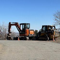
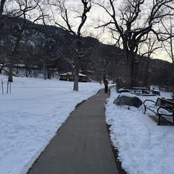
This trailhead is easy to get to from many parts of Boulder and has a dirt parking lot for about 20 cars if you aren't close enough to bike or walk here, and I am not. There is also overflow parking on a nearby neighborhood street, but read the parking regulation signs carefully. Because some of the trail from here is closed for wet, muddy conditions right now, parking is relatively easy. But in good weather it can be quite busy. There are a lot of runners, cyclists and dog walkers starting out from this point. I bike and depending on whether I will be accessing a paved part of the path around the nearby East Rec Center or north to the junction with the Boulder Creek Path or the dirt trail heading south to Marshall Rd, I can use either my road bike or mountain bike. I see mostly others on road or hybrid bikes on the trails. I would say runners and dog walkers predominate at the trailhead.

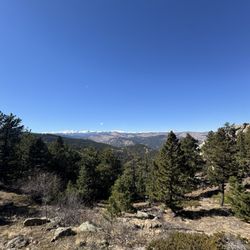
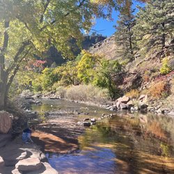
Gorgeous and Flat. This wonderful trail follows South Boulder Creek Trail for 1.5 miles between Baseline & South Boulder Rd and another 2 miles between South Boulder Rd & Marshall Rd. Tons of birds (Bobolinks, duh!) No dogs. Horses are allowed. The historic Dorn Barn (c. 1900) on the Van Vleet property is pretty cool (photo from Fall - City of Boulder web site), as is the Abernathy Barn at south end of trail across from creek. It's currently grazed and ranched, and all the little calves earlier this Spring were pretty damn cute. The Moms didn't seem to mind.

A scenic trail with both a paved concrete & dirt/mulch like path. Walked for about 30 minutes in but was unsure of where the trail led or when it would stop. Initially the parking lot was empty but as we got back the parking lot was packed. Be aware if trying to get there in the late afternoon, parking may be tight.

Always a great place to walk or bike! You can connect to dozens of miles of paved and gravel trails in Boulder. Parking is limited, but you can always park at the East Boulder rec center too! Lots of plant life and you get the creek. Nice picnic areas and dirt dog trail. Off leash ok with tags. Great place for relaxing! read more


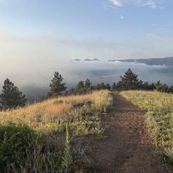
This is part of the S. Boulder Creek Trail, but this section is more scenic. A multi-use path and a pleasant stroll on the completely flat crushed gravel path. Very popular with joggers for this very reason. Wildflowers and songbirds at the time of this posting. 2.5 miles in and out. Park at Baseline of Cherryvale Trailhead. A few offroad spots on Boulder Ave. read more


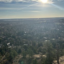
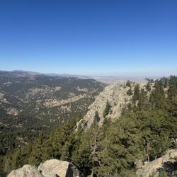
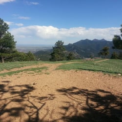
Great trail to take your dog on! This trail has a sidewalk for bikes and a trail by the water for dogs, so there is some nice separation from the bikes. This trail Is never really too crowded and has a lot of places to stop and sit by the creek. You can also walk part of the trail and then it connects over to the East Boulder dog park and rec center. So it's nice if you go to the dog park and also want to go on a walk. The trail is pretty long and has some of the better views in Boulder. read more

 the creek. - Hiking Near Me - Boulder, Colorado")
This walk is flat and it runs right by the creek. The mosquitos were active in the tree shaded areas. Dog pooh in several places and some considerate dog owners bagged the pooh but left the full bags on the trail. This trail is ok for a casual stroll, it is busy and bikes are allowed. read more


This trailhead is easy to get to from many parts of Boulder and has a dirt parking lot for about 20 cars if you aren't close enough to bike or walk here, and I am not. There is also overflow parking on a nearby neighborhood street, but read the parking regulation signs carefully. Because some of the trail from here is closed for wet, muddy conditions right now, parking is relatively easy. But in good weather it can be quite busy. There are a lot of runners, cyclists and dog walkers starting out from this point. I bike and depending on whether I will be accessing a paved part of the path around the nearby East Rec Center or north to the junction with the Boulder Creek Path or the dirt trail heading south to Marshall Rd, I can use either my road bike or mountain bike. I see mostly others on road or hybrid bikes on the trails. I would say runners and dog walkers predominate at the trailhead. read more

15 years ago
Gorgeous and Flat. This wonderful trail follows South Boulder Creek Trail for 1.5 miles between Baseline & South Boulder Rd and another 2 miles between South Boulder Rd & Marshall Rd. Tons of birds (Bobolinks, duh!) No dogs. Horses are allowed. The historic Dorn Barn (c. 1900) on the Van Vleet property is pretty cool (photo from Fall - City of Boulder web site), as is the Abernathy Barn at south end of trail across from creek. It's currently grazed and ranched, and all the little calves earlier this Spring were pretty damn cute. The Moms didn't seem to mind. read more

7 years ago
A scenic trail with both a paved concrete & dirt/mulch like path. Walked for about 30 minutes in but was unsure of where the trail led or when it would stop. Initially the parking lot was empty but as we got back the parking lot was packed. Be aware if trying to get there in the late afternoon, parking may be tight. read more


Bobolink Trailhead is a flat and easy trail that connects to many trails including the popular Boulder Creek Trail. It's a very popular Trailhead so most mornings parking can be a bit challenging. It's a multi use trail with cyclist, runners, dog walkers and trekkers. It's a great starting point to connect to others trails throughout Boulder. read more


15 years ago
12 years ago
7 years ago
More info about Bobolink Trailhead
Baseline Rd
Boulder, CO 80302
Directions
Hours
Outdoor Amenities
Ask the Community - Bobolink Trailhead
Review Highlights - Bobolink Trailhead


Why does Yelp recommend reviews?
1 review that is not currently recommended
The reviews below are not factored into the business's overall star rating.
8 years ago
Bobolink Trailhead - hiking - Updated June 2026
Best of Boulder
People found Bobolink Trailhead by searching for…
Off Leash Dog Hikes in Boulder, CO
Hiking Trails With Waterfalls in Boulder, CO
Natural Hot Springs in Boulder, CO
Empty Parking Lot in Boulder, CO
Mountain Bike Trails in Boulder, CO
Scenic Places to Walk in Boulder, CO
Dog Friendly Hiking Trails in Boulder, CO
Stroller Friendly Hikes in Boulder, CO
Beautiful Views in Boulder, CO
Places to Take Pictures in Boulder, CO
Trending Searches in Boulder, CO
Amusement Parks near Bobolink Trailhead
Beaches near Bobolink Trailhead
Black Owned Nail Salons near Bobolink Trailhead
Boat Rental near Bobolink Trailhead
Cliff Jumping near Bobolink Trailhead
Creeks near Bobolink Trailhead
Dog Friendly Trails near Bobolink Trailhead
Fishing Spots near Bobolink Trailhead
Free Kids Activities near Bobolink Trailhead
Jet Ski Rental near Bobolink Trailhead
Outdoor Activities near Bobolink Trailhead
Pick Your Own Farms near Bobolink Trailhead
Public Shower near Bobolink Trailhead
Rock Quarry near Bobolink Trailhead
Running Trails near Bobolink Trailhead
Scenic Drive near Bobolink Trailhead
Secluded Spots near Bobolink Trailhead
Soccer Store near Bobolink Trailhead
Splash Pad near Bobolink Trailhead
Strawberry Picking near Bobolink Trailhead
Sunrise View near Bobolink Trailhead
Swimming Holes near Bobolink Trailhead
Swimming Lakes near Bobolink Trailhead
Swimming Pools near Bobolink Trailhead
Watch Sunset near Bobolink Trailhead
Browse Articles
Browse Nearby
BEST of Boulder, Colorado Coffee near Bobolink Trailhead
BEST of Boulder, Colorado Restaurants near Bobolink Trailhead
BEST of Boulder, Colorado Things to Do near Bobolink Trailhead
BEST of Boulder, Colorado Breakfast near Bobolink Trailhead
BEST of Boulder, Colorado Walking Trails near Bobolink Trailhead
BEST of Boulder, Colorado Parks near Bobolink Trailhead
BEST of Boulder, Colorado Hot Springs near Bobolink Trailhead
BEST of Boulder, Colorado Caves near Bobolink Trailhead
BEST of Boulder, Colorado Campgrounds near Bobolink Trailhead
Browse Brands
Related Searches in Boulder, CO
Affordable Kayak Rental Services in Boulder, Colorado
Best Fishing Locations and Guides in Boulder, Colorado
Best Nature Trails for Hiking in Boulder, Colorado
Best Places for Horseback Riding in Boulder, Colorado
Check Out Off Road Trails in Boulder, Colorado
Discover Dog Friendly Trails to Explore in Boulder, Colorado
Discover Kid Friendly Hiking Trails in Boulder, Colorado
Discover Scenic Bike Paths in Boulder, Colorado
Discover Scenic Mountain Bike Trails Near Boulder, Colorado
Discover Scenic Waterfall Spots in Boulder, Colorado
Discover the Best Night Hike Trails in Boulder, Colorado
Dog-Friendly Hikes With Dogs in Boulder, Colorado
Enjoy Camping Adventures Around Boulder, Colorado
Enjoy Exciting Mountain Biking Adventures in Boulder, Colorado
Enjoy Kayaking Adventures in Boulder, Colorado
Enjoy River Tubing Adventures in Boulder, Colorado
Enjoy Tent Camping Spots Around Boulder, Colorado
Enjoy Water Activities and Fun in Boulder, Colorado
Enjoy a Beautiful Waterfall Hike in Boulder, Colorado
Enjoy the Best Picnic Spots and Ideas in Boulder, Colorado
Enjoy the Best Walking Path in Boulder, Colorado
Enjoy the Best Walking Trails in Boulder, Colorado
Exciting Cliff Jumping Spots in Boulder, Colorado
Experience Thrilling White Water Rafting in Boulder, Colorado
Explore Beautiful Parks and Green Spaces in Boulder, Colorado
Explore Easy Hikes Perfect for All in Boulder, Colorado
Explore Fun Activities to Do in Boulder, Colorado
Explore Popular Campgrounds Near Boulder, Colorado
Explore the Best Beach Spots in Boulder, Colorado
Explore the Best Boating Spots in Boulder, Colorado
Explore the Best Swimming Holes Around Boulder, Colorado
Explore the Best Trail Options in Boulder, Colorado
Family Friendly Hiking With Kids in Boulder, Colorado
Find Beautiful Views in Boulder, Colorado
Find Popular Ziplining Spots Around Boulder, Colorado
Find the Best Scenic View Locations in Boulder, Colorado
Great Places to Walk in Boulder, Colorado
Hiking Trails With Waterfalls in Boulder, Colorado
Off Leash Dog Hiking Trails in Boulder, Colorado
Plan a Scenic Drive Route Near Boulder, Colorado
Popular Outdoor Activities to Try in Boulder, Colorado
Popular Picnic Spots to Visit in Boulder, Colorado
Safe River Swimming Areas in Boulder, Colorado
Safe and Fun Parks for Kids in Boulder, Colorado
Top Climbing Spots and Gyms in Boulder, Colorado
Top Running Trails to Explore in Boulder, Colorado
Top Swimming Lakes to Enjoy in Boulder, Colorado
Top Swimming Spots and Pools in Boulder, Colorado
People who viewed Bobolink Trailhead also viewed
Gregory Canyon
6 reviews
Davidson Mesa Scenic Overlook
12 reviews
Royal Arch
34 reviews
Bald Mountain Scenic Area
3 reviews
Boulder Creek Path
23 reviews
St. Vrain State Park
28 reviews
Coalton Trail Head
3 reviews
Settlers Park
3 reviews
Golden Ponds Park & Nature Area
10 reviews
Farmers High Line Canal Trail
1 review