Big Stump Grove Trail Photos


 carved \"I LOVE GLE\" and then came to their senses. - Hiking Near Me - Cedar Grove, California")
You might also consider
More like Big Stump Grove Trail
Recommended Reviews - Big Stump Grove Trail
Start your review...

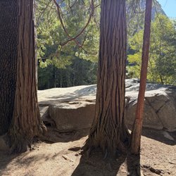
Near the bathrooms bordering a large parking lot, a trail will lead you to some cool sights. The trail has 200 feet of elevation gain and about 1.5 miles round trip. It is not well-marked, which sucks because it can be a bit of a maze, so if you don't want to miss anything, you could drive 2 miles up the road to the Kings Canyon visitor center for a map. Bring bug spray and be sure to get your ears because that is where the weird rectangle flying things will hover and buzz near you like police helicopters over Long Beach at night. Sights: Just past a meadow is OLD ADAM, a forty-foot hollow but imposing piece of fire and lightning-scarred, centuries old wood that is not a tree, but merely a piece of one of the largest trees likely to ever exist. A ranger climbed inside to shine a light and found the carved names of history's passersby, including "Sparrow 1758" but they recommend a selfie instead. It is one of the oldest written histories of a European in California. If you pass a sign designating a mill that was once there (which is silly, they could say, hey, look at this big hole, it used to have a giant carved blood-soaked eagle used in Native American sacrifices, but yeah, it's a hole), you will find MARK TWAIN STUMP. Once one of the largest sequoias, the tree was cut down in 1891 so that a cross-section could be displayed in natural history museums in New York and London. The rest became grape stakes and fence posts. They added stairs so that you can climb it. On the way to the Stump I followed a sign to Feather Bed. I didn't see anything of interest. Maybe it's called FEATHER BED because you will fall asleep it is so boring. However, at the end of the trail I found SAWED TREE. Sawed Tree is a giant sequoia stump, spiked like Bart Simpson's hair, bearing the scars of a crosscut saw. I don't know if you are allowed to climb it, but it's climbable. I guess anything is climbable, really. Except my sister. Big Stump Grove is one of many sites on the north half of the park including General Grant Tree and Panoramic Point (3.7 mi), Junction View (15 mi up), Hume Lake (16mi), the Scenic Byway and Boyden Cavern (24mi), Grizzly Falls (29mi), Roaring River Falls (36 mi), and Mist Falls near Road End (40mi). read more


More info about Big Stump Grove Trail
Kings Canyon National Park
Cedar Grove, CA 93633
Directions
Hours
Outdoor Amenities


Big Stump Grove Trail - hiking - Updated May 2026
Best of Cedar Grove
People found Big Stump Grove Trail by searching for…
Scenic Drive in Cedar Grove, CA
Hiking Trails With Waterfalls in Cedar Grove, CA
Scenic Night View in Cedar Grove, CA
Visitor Centers in Cedar Grove, CA
Redwood Trees in Cedar Grove, CA
Stair Climbing in Cedar Grove, CA
Canyoneering in Cedar Grove, CA
Off Road Trails in Cedar Grove, CA
Running Trails in Cedar Grove, CA
Things to Do in Cedar Grove, CA
Swimming Lakes in Cedar Grove, CA
View Points in Cedar Grove, CA
Lakes & Ponds in Cedar Grove, CA
Walking Trails in Cedar Grove, CA
Beach Hiking Trails in Cedar Grove, CA
Browse Nearby
BEST of Cedar Grove, California Parks near Big Stump Grove Trail
BEST of Cedar Grove, California Campgrounds near Big Stump Grove Trail
BEST of Cedar Grove, California Pizza near Big Stump Grove Trail
BEST of Cedar Grove, California Restaurants near Big Stump Grove Trail
BEST of Cedar Grove, California Hotels near Big Stump Grove Trail