Cancel

    Open app

    Search

    Alta Peak

    5.0 (2 reviews)

    Alta Peak Photos

    You might also consider

    Recommended Reviews - Alta Peak

    Your trust is our priority, so businesses can't pay to alter or remove their reviews. Learn more about reviews.
    Yelp app icon
    Browse more easily on the app
    Review Feed Illustration
    Photo of Kaori M.
    269
    1738
    1482

    13 years ago

    Helpful 0
    Thanks 0
    Love this 0
    Oh no 0
    Photo of Peter C.
    35
    28
    20

    10 years ago

    Helpful 0
    Thanks 0
    Love this 0
    Oh no 0

    Verify this business for free

    Get access to customer & competitor insights.

    Verify this business

    General Sherman Tree

    General Sherman Tree

    4.6(138 reviews)
    19.7 km

    Visited the General Sherman Tree at Sequoia National Park and overall it was a good experience, but…read morethere are definitely a few things to be aware of. The tree itself is truly impressive and worth seeing at least once--it's amazing to stand in front of something that massive and historic. That said, expect large crowds and long lines, especially during peak times. It can take a while just to get close enough for photos. Parking was also a challenge during our visit. Spots fill up quickly, so you may need to circle around or wait. We started from the top parking lot, and while going down is manageable, the hike back up is pretty exhausting, so be prepared for that. One downside was the restroom condition--they were quite dirty and looked like they hadn't been maintained well that day. Also, just a heads-up: not everyone we encountered was friendly, so patience helps in crowded areas. Despite these issues, it was still a memorable visit. Just plan ahead, bring water, and be ready for a bit of a workout.

    If you haven't seen the largest tree(s) on earth, you are missing out, get your hiking boots on…read morecome witness some of the most beautiful trees and landscape to be found. Parking can be a beyotch, especially when the main lot is closed, but stay patient and people are coming and going constantly, but whatever you do... DO NOT PARK on the road itself. Don't do it. You can do small short hikes around the grove or during winter you can strap on some snow shoes, or crampons, based on conditions, and you can get further out into the grove or park itself. I just be prepared for whatever you're planning on doing that will guarantee you have a successful outing

    Photos
    General Sherman Tree
    General Sherman Tree
    General Sherman Tree

    See all

    Sequoia And Kings Canyon National Parks - Giant Tree Museum - also has restrooms and exhibits.

    Sequoia And Kings Canyon National Parks

    4.6(554 reviews)
    23.2 km

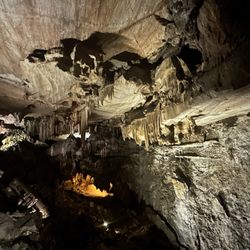
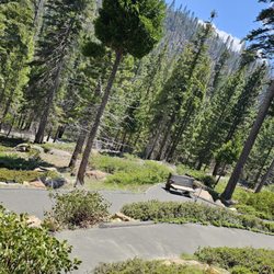
    Before I visited the place, I had heard of the Sequoia National Park several times throughout my…read morelife and all these mentions amounted to me believing one large fact: that the place was a sprawling, maybe never ending, sea of deep forest pageantry. And do not get me wrong, the place is in fact miles and miles and cubic centimeters of forest as commonly imagined. It had tall trees, meadows, dirt paths with twigs and shrubs all around and views so expansive the word majestic comes to mind. But after walking the same scenery for hours the beauty in green became a dull brown motif. Wood sprites might have heard my words or seen my unimpressed and tired face because Sequoia stopped being a forest of trees and green and it started to become a land of different weathers that not only gave me new challenges and vistas to experience but it also gave me beauty I had to endure. 
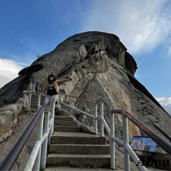
As I saw my friend Denise walk into a spherical cloud of fog, I realized that this place oscillated between being both proof of nature's magic and her jagged disposition. The fog seemed like a portal to Avalon where Pulk waited with prose, but it was also a reminder of all the sailors and drivers lost when the thickness of mist impairs good visual choices. The fog sphere was seen after Denise and I walked for hours, uphill, to see Morro Rock. As we walked up, we first passed mist that seem to have broken from a cloud. This was a sensational moment. She and. had both skydove but this is the first time where we felt like we walked through cloud veils, insetad of zooming past them with the hope of gravitiy abandon. I do not think I will ever re-feel the sensation of walking on cloud air, literally. 
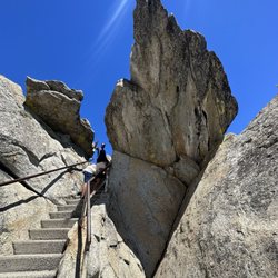
She and I got separated. I thought I could follow the signs. But the signs were tricksters. As I walked toward the museum I saw a sign that said this way to Crescent Meadow. I did not see a sign that said this way to Crescent Meadow (pointing to the left) and this way to the Museum (pointing ahead). I assumed that because I no longer saw signs assuring me that I was on the right path, I must have gotten into the wrong one. I share this as the biggest piece of advice that I wish to give: Stay the trail, despite not having signs of reassurance that you are still in the right direction. The signs, and my broken internal compass, are both valid reasons as to why I eventually left the designated path and got lost. Like legit lost in the wilderness of Sequoia. I was not in an episode of Naked and Afraid but I did feel scared, disoriented and like I would not see my life tomorrow. Before I got to this point of panic, I arrived at a bluff of a white mountain that saw me greet miles of green pines that streched as far as the eye could see. It was a Rocky-like-triumph moment, except that I had to drag myself, as I sat, down this white mountain, but that was my survival experience that I am proud to have endured. After sliding down, I searched for paths that seemed walked on before, and found several that I had to follow and eliminae. I climbed over trees by hugging their fallen bark, and almost lost my shoe. I continued and eventually found a path and others humans. I was save for now. I got lost again but this time my survival was quicker as I walked down to the road. Rangers told me that I was not able to ride in the truck after I explained I was scared and unable to find my way twice. One of them told me to follow the road and eventually I would hit the museum. I did just that and I found my friend Denise waiting in the museum. After hugs laced with relief, she and I continued our trek to Sherman. But we got hit by rain. I had a hoodie. She did not. Her face looked beautiful covered with the remains of heavy rain. We walked and the sleet followed. We were wet, damp, and we were scared. What could be next? We could not find our path to Sherman. We waved people down, hoping that someone would take us to our car near Sherman. Eventually, we met Chester and he let us both into his car. The snow now was falling hard. She and I did not expect snow. We did not expect white to fall from the sky not when we were promised green on top of green all around. We got to the car and she drove in Snow for the first time. It was both scary and and beuatiful. I imagined that I was in snow caped mountains seeing frozen giants walk around. The night was gray. The monsters were there. She worried about us not having snow tired but still we drove down the snow covered pines, in a pilgramage to safety. Before we left the park we saw mist contrasted in the dark of the knight. It was a spooky evening, yes, the one that frames scary stories. But for us the night mist was further proof that Sequoia offers weather that is cyclical within a day. With space from the experience, I am only happythat I visited the place and was ensconsed by its many seasons. And, grateful that I survived the beauty of it all.

    Sequoia national Park is quite the experience, but I want to warn you. There is a very long drive…read moreto get up to see the sequoia trees. I believe it was roughly 45 minutes to get up there to begin to see these trees and the road was very long and windy and at one point I was for sure we were going the wrong way even though there's only one way I was for sure. But after that 45 minute drive up, you begin to see these remarkably tall, beautiful sequoia trees as far as they I can see and each one of them more breathtaking than ever we went during winter so I definitely encourage you to check and make sure that you don't need to bring snow chains because to travel to a lot of the areas in winter and other seasons, you might just need snow chains to make it My family had a great time we spent just a few hours walking around and enjoying the beautiful view the fresh Mountain air and getting a chance to interact with other people traveling from all over the country who had come to visit as well. This is also something you must add to your bucket list because even though we only got to see 1/10 of this park, we already have it put back on our bucket list to go again because there's so much more to see here truly breathtaking views and just a relaxing experience all the way around.

    Photos
    Sequoia And Kings Canyon National Parks - To the top of Moro Rock

    To the top of Moro Rock

    Sequoia And Kings Canyon National Parks - Patty & Levi

    Patty & Levi

    Sequoia And Kings Canyon National Parks - Giant Forest

    See all

    Giant Forest

    Sequoia National Forest and Giant Sequoia National Monument

    Sequoia National Forest and Giant Sequoia National Monument

    4.7(39 reviews)
    66.8 km

    I don't know how to even describe this park, maybe, magical... The sequoias are majestic with sugar…read morepines sprinkled all around. I was here with the Sisters Corp. to do some volunteer work. I did not want to miss the opportunity to give my time for this beautiful place. This is my first time to visit this National Park and I know now it will not be my last. My first day at the volunteer camp group site as we gathered at the table to meet each other and go over the agenda for the weekend we had the opportunity to see a black bear casually roam through our campground near the tents (one of them was mine). We were all informed prior to arriving not to leave any scented items in the tents. No one wonder the bear kept moving along, but with the help of our camp host shooing it away from the campground. This is something we learned from the rangers, is to shoo them away so they don't get in the habit of coming around. The park offers many hiking trails, I had the chance to do one of many, which was the Long Meadow Trail. Very beautiful, plenty of foliage and evidence of a bear in the area. Another part of the park I got to visit was General Sherman. There is a park ranger that will tell you the history of the General Sherman tree. You can wait in a long line to take a pic in front of the tree with a General Sherman sign. Or you can take a pic around the fenced majestic tree. I choose not to wait in line. I had the chance to shuttle to General Sherman tree from the Museum. The Shuttle is free and seems to come every 10-15 min. From General Sherman I also shuttled to the Lodgepole marketplace and visitor center. In this area are bathrooms with showers (coin operated, quarters). The Marketplace has an area to order some food and also a section where you can purchase some ice cream by the scoop. The store offers assorted ice cream bars. The visitor center offers gift items as well as the marketplace. At the front of the visitor center they had a ranger available at a booth if you had any questions. This place is quite busy! Parking lot is a madhouse. Nearby is a campground you may want to check out or ask the ranger for some info. If you can, arrive early, find parking at the Museum and shuttle to everything if you can. Warning, when I was doing volunteer work in the parking lot across from the museum we witnessed a black bear enjoying some berries in the bushes. I'm not sure if they will venture into the parking lot with a lot human activity going on but be careful what you leave in your car, anything and everything with a scent. The park has so much to see. I look forward to returning to volunteer and to take advantage of what the park has to offer.

    Best national park I've ever been to and that's saying a lot…read more It's magical, and I highly recommend getting to the Sherman trailhead prior to 9:30am if you want a parking spot. Takes about an hour to get in there, up there and parked so plan accordingly. The congress trail was amazing and for a 3.5 mile hike it took about 2.5 hours with frequent stops for pictures. Highly recommend a stop at lodge pole for refreshments and merch. Incredible experience from start to finish.

    Photos
    Sequoia National Forest and Giant Sequoia National Monument - One of the restaurants in the National park

    One of the restaurants in the National park

    Sequoia National Forest and Giant Sequoia National Monument - Morro Rock.

    Morro Rock.

    Sequoia National Forest and Giant Sequoia National Monument - Fungi

    See all

    Fungi

    Eagle Lake

    Eagle Lake

    5.0(10 reviews)
    5.0 km

    Lengt:h 7.2 Total Miles…read more Elevation Gain: 2,100 feet Trail Type: Out-and-back Skill Level: DIFFICULT Duration: Backpack or day hike Season: Best July through September Trailhead Elevation: 7,900 feet Top Elevation: 10,000 feet In September, this sun-exposed trail was lined with a scattering of Indians Paintbrush, a sampling of the fuller wildflower bouquet, which blooms on these slopes in the spring. After 1 mile, turn right at the White Chief Trail junction. The Eagle Lake Trail shifts in style from a straight track to a series of switchbacks that chew into the elevation. At the junction with the Mosquito Lakes Trail, turn left and set your sites on Eagle Lake, 1.7 miles away. Alternatively, hikers could turn right here and hike the same distance to the lowest of four Mosquito Lakes located one ridge west of Eagle Lake. The ascent tapers as you follow Eagle Creek to its source, passing a pair of unique "sink holes" where the water disappear underground into strange craters. Pass through a wooded meadow and dissect an alpine bounder field. The trail mounts a rock slope beneath Eagle Lake and offers fine northeast views toward Sawtooth and Mineral Peaks. The route to this lake follows the same trail for the first 2 miles, ascending steadily up the west side of the Mineral King Valley. The trail ends at the north end of Eagle Lake, where a small dam, maintained by Southern California Edison, enhances the volume of the lake. A path continues through the trees along the eastern shoreline. Large rocks act as islands in the lake, which gets more picturesque the further you walk.

    We just went to Eagle Lake for an overnight camping trip. It's mid-August…read more We first stopped at the ranger station to get some information about the trail. That's where we rented bear can for our food. The rangers were really nice and knowledgeable. We pay $15 for camping permit and $5 for bear can rental fee. It was 4 of us and our 2 year old son. We started hike just OK, but it's ALL UPHILL till the lake. Our son did great, covered good mileage, but of course we ended up carrying him later. If you are going with little kids, it's best to have proper carriage because the terrain gets pretty rocky and steep. It's best if you have both hands free to climb up there. Hiking sticks strongly recommended. It is one of the hardest back-country camping trip, but it was rewarding! The meadows were so beautiful, saw wild life, and the sense of accomplishment was priceless!

    Photos
    Eagle Lake
    Eagle Lake - Hike to Eagle Lake

    Hike to Eagle Lake

    Eagle Lake - Hike to Eagle Lake

    See all

    Hike to Eagle Lake

    Alta Peak - hiking - Updated May 2026

    Loading...
    Loading...
    Loading...