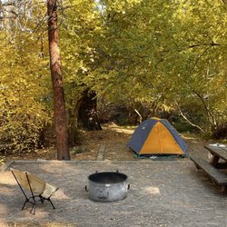
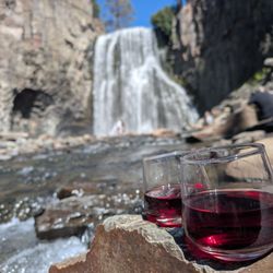
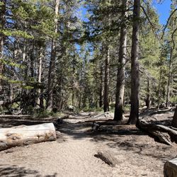
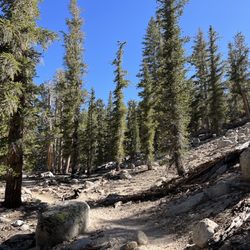
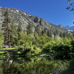
Big Pine Lakes Photos


You might also consider
More like Big Pine Lakes
Recommended Reviews - Big Pine Lakes
Start your review...

Reviews With Photos

WOW WOW WOW! Absolutely breathtaking! July 2021 Review: we camped at the campsite nearby so it was literally a 10 min walk to the parking lot. We started around 6:20am, got to the first lake around 10am & finished around 2:30pm. My Apple Watch recorded about 5 miles to the first lake & this hike kicked my ass. But totally worth it! TRAIL: this trail has every type of condition - flat land, through the forest-ish, switchbacks, over some rocks, incline, over a bit of water, everything, so be ready. There is also little to NO SHADE so I would recommend hiking in the early AM. When we hiked back down, the sun was burning us & there is no escaping it so reapply sunscreen! And when you hike through the forest-y area, a lot of bugs so spray yourself with bug spray as well! If you want to camp overnight on the trail, you will need a permit! Here is some advice for the hike: -bring sturdy hiking boots -hike in shorts because it gets HOT -bring plenty of sunscreen & bug spray (reapply a lot) -bring plenty of water (need about 2.5-3 liters) -wear a hat -small towel if you want to dip your feet in the lake -bring a packed lunch with fruit HIGHLY recommend! Definitely worth the struggle/challenge.

Come early, come prepared! A pretty difficult hike if you're not an average hiker but well worth it for the amazing out of this world views. Parking/location: fairly easy to find. There's a Chevron and Shell station just down the road prior to coming up. Parking is minimal but it's not too crowded. YOU WILL LOSE service once you're up in the area. There's a small bathroom right at the parking lot. Hike itself: it is not easy, I repeat not easy. There were few hikers that we came across, but a good amount were exhausted and came later in the day when it was hot and even raining later(weird weather right now) Come early, we started our hike around 7:45 and didn't arrive to lake 1 til about 11:45 with many frequent breaks throughout. It gets hot quick here, and so taking time to find shade, drink water is important. The hike to lake 1 is about 5 or so miles so total distance is 11 miles minimum. Lake 1-2 are right by each other so if you make it to lake 1, head to lake 2 for better views, and a nice picnic spot right by the water. What to bring: Hat Light long sleeve (for mosquitoes) Boots Walking sticks (great if you're camping) Water!! (At least 2L per person) Snacks or lunch (we had a great small picnic at the base of lake 2) Change of clothes (if you're swimming) Tripod (for great group photos) Overall, watch videos online and do your due diligence and don't underestimate this hike! Come early morning to beat the sun (no shade mile 2-3). An amazing amazing hike!!

This is THE most gorgeous hike I've had the pleasure of experiencing in CA! Maybe it's because I'm so used to the dry mountainous hikes/desert hikes, but all this rushing water and greenery had me swooning. We hiked to the unceremoniously named Lakes 1 and 2. Lake 2 is the prettier of the two, and apparently the best of all 7. It's not far from Lake 1, so don't despair if you're already dying. All together it was about 11 mi. I hike quite a bit, so I thought the trail was moderately difficult. The elevation gain is not extreme, and yeah there are a few switchbacks in the beginning, but nothing that'll completely wipe you out. My bf, however, is a novice hiker and was totally bushed by the end. Bring plenty of snacks and water! I was bracing myself for a ton of mosquitoes, but blessedly there were none for us. There are a ton of rushing rivers next to the trail to dunk your hats into for sweet relief. There are some exposed areas, but for the majority of the trail I wasn't trying to hunt down shade. DO bring swimwear to take a refreshing dip into the lake at the end! The brilliant aqua colored glacier runoff is even more pretty in person. Yes, it was a bit cold, but oh so welcome after a long hike. And yes, we did carry an avocado floatie up with us...

A beautiful hike in the Sierra Nevada Mountains with breathtaking views the whole way. I had lofty goals of hitting all 7 lakes on a day hike when I was planning this adventure. Once we started the hike and the trail alone was beautiful, I knew we would never make all 7 in one day. It turned out we made it to 3 lakes, enjoying some relaxation time at each taking in the scenery and fresh air. This was the perfect new plan for a first time visit. It is about a 10 minute drive up the mountain to the trail-head where there is a small parking lot for day hikers. Make sure to use the restroom there as you will not find any the rest of the day. The path is well marked with periodic signs along the trail when you can go a couple different ways. to reach the lakes, you want to follow the North Fork signs. There are plenty of people on the trail so you will know you are going the right direction. The first lake is approximately 4.5 miles in with lakes 2 and 3 shortly there after (about 5 min walk further to lake 2 and 10 min walk further to lake 3). There are ways to get down to the shore if desired, but I chose to enjoy the views from the rocks above. Total elevation gain is around 2500 feet. Lakes 4-7 are significantly further and if you want to see all the lakes in 1 day, you must start very early (sunrise) to make it back before dark. There is also the Black Lake which instead of following the trail to Lake 1, you can follow a different sign to that lake. Next time this is a must for sure. The highlight of this hike is the majestic blue lakes with the mountains behind them. A must see for any nature enthusiast. Although not the highlight, the trail provided some spectacular scenery which we had to take pictures of. From the beautiful fall colors to the waterfalls, and even the icicles still forming in October, it was a wonderful addition to our hike. October is kinda iffy when it comes to weather and if the path will be clear to hike. We lucked out with gorgeous weather! Started off at a crisp 38 degrees and warmed up to the high 60's with lots of sun. Hoping to go back here next year when I can make it a true full day hike and see all the lakes or get a camping permit and stay a night or to in the great outdoors. Note: Driving up from LA, it is about 5 hours. If you are not camping, I would recommend staying in Bishop which is 15 minutes past Big Pine.

We had a great time hiking to Big Pine Lakes 1 & 2. We had a late start driving up from Los Angeles and didn't start at the trail head until 1230P so we knew we'd be limited on time. We stayed out about 5.5 hours and did around 10.6 miles with 2,600ft elevation gain (starting at 7,836 ft reaching 10,187 ft). The weather was perfect, I actually had a few too many layers on and needed to remove some but was happy that I had brought gloves for the walk back to the car. My hands started getting cold later in the evening. We reached the first lake in about 2.5 hours and this was after taking several breaks along the way and we made it down a bit quicker which is to be expected. We left our hiking poles behind and were fine. There was only really one area that was flooded out that we needed to get around much closer to approaching Lake 1. Had we started close to sunrise I would have liked to go further out but we had a hard pressed turn back time since I didn't want to hike back after dark. The views of the lakes, glacier and temple crag were all really pretty. There were some nice views of fall foliage but really we had missed the prime for that and many trees had already dropped their dead leaves. I'd say this is a moderate hike and pretty achievable for just about anyone. We still aren't into overnight camping but are pretty avid day hikers staying out ALL DAY and trekking many miles so less than 6 hours and only 10 something miles seems more like a nice long walk to me. Enjoyable nonetheless with some really awesome views of the lakes. I can imagine this hike being even more gorgeous after first snow. Parking and restrooms with paper at trailhead.

I wondered to myself why when I yelped Big Pine Lakes I did not see many reviews of the hike but after completing the hike, I now understand why. For starters, it shouldn't be a strenuous hike...but it IS. The elevation gain will suck the life out of you if you're not use to it. They even sell oxygen cans in town! The first lake is easily accessible within 2.5 hours time if you don't take a lot of breaks. Therefore it's a 5 hour hike R/T if you stop after the first lake which isn't too shabby. My husband and I made our trek to the third lake and back and it took us about 9 hours R/T. We stopped and had lunch at the third lake before my husband made the trek back to the first lake and decided to take a dip in it. This was in July in the scorching heat but let me tell you, the water was FREEZING cold though. But it was a once in a lifetime experience and he had to do it regardless of how frigid the water was or not. Let me tell you...I can't even explain how amazing this hike is. The excitement we felt when we were hiking, hiking, hiking then all of a sudden you look to the left and you see the crystal clear blue water. It was truly remarkable. Out of this world...and to think it exist in California! My husband and I rank this hike among our top hikes! He's currently gone on deployment but I am considering doing this hike again in the winter to see how the lakes look frozen over...will definitely post an update on that if it happens!

Beautiful and worth the 13 mile hike (to Lake 1-3)! We got there around 8.30am on Aug 25th. Hiked for 6 hours but spent time there for about 9 hours in total. Please bring enough water and be prepared for a crazy weather. It was raining and hailing on the way down the mountain. The weather changed from hot to cold pretty quickly. Luckily, I had a jacket and cap.

Parking: 2 lots, one for day and overnight. Restrooms at trailhead. 7 lakes. Around 12-13miles round trip for lakes 1-3 Great California gem. Beautiful scenery all around. It's a strenuous hike but you will be rewarded with amazing glacier fed lakes that is a beautiful turquoise color on a sunny day. Lake 2 is a favorite with Temple a Crag in the background. If you plan on backpacking plan ahead to get your permit, day hikes not required. And check out the glacier trail which will lead you to the Palisades and views are even better! 8 miles RT from second Lake so backpacking is recommended unless you have unlimited energy to do it as a day hike. Summer months please wear bug repellent! Mosquitos are really bad here.

This area of California is simply breathtaking. Fresh air, trout fishing, alpine glacier-fed lakes, incredible views, and a rushing river are all here for your enjoyment in a non-crowded unspoilt area of California. Gems like this are sadly diminishing at an accelerated rate these days. I didn't see one piece of trash or evidence of civilization during the time I camped up here. It was so refreshing. There are 7 lakes you can hike to if you backpack / camp along the way. It is relatively "easy" to get to the first two lakes, apparently a 2-3 hour hike one way. I was advised by a local to begin the hike very early in the morning in order to avoid the hottest part of the day. I was also told the hike is very barren, and has no shade, until the point you get to the lake areas. I am saying "i was told" because I did camp up here but did not have time to do the hikes- will do next time. The drive up from L.A. is incredibly boring and looong (about 5 hours give or take), except for the Joshua trees in Victorville. In a couple of towns the 395 turns into a street so expect delays at streetlights and behind large trucks and campers. Take your time and be safe. We stayed at the Upper Sage Flats campground, the second one you come to as you drive up. I looked at them all and each one was beautiful.

Level 7 on difficulty because of the uphill terrain getting to the lakes. It's on the high end of the moderate scale. Surely depends on the time you begin your hike, and season. Roundtrip hike took us approx 6 hours of just walking. We left Los Angeles around 2am. Parked and began walking the trail at 7am. Early enough when it was still cold. At noon, it was rather warm but this trail offers tons of shade. I recommend getting trail directions prior due to no cell reception in this area. There are 7 lakes but once you see the first 2 or 3, they're all the same. Coming back to the parking lot, it's cruising. No permit needed and parking is free. I would only recommend this hike to someone in shape and with experience. Tons of scenery. Take a full battery for pics. Lots of water and snacks.

My new fave hike...beauty that's only 5 hours from San Diego! Contemplated doing this hike in May due to mixed weather reports. After much research I went with outdoor project's weather report, which was pretty much on point. Memorial day weekend 2018 had projected weather of partly cloudy/sunny 58° and it turned out perfect. We parked at big pine campground's overnight lot (on Glacier lodge road) & headed out at 915 am. This hike is about 11 miles with gradual inclines, long switchbacks & some rocky terrain. It took us about 3 hours to reach third lake. Could have been faster, but photo ops were a must & lunch was too! It's gorgeous out here! You'll walk alongside the river for some time, cross a few creeks, bridges, be wowed by cascades & in awe with lakes! There are crowds during weekend so go early! Definitely coming back for lakes 4-7, as an overnighter of course!

WITHOUT REGRETS! Except for one. The Crew and I backpacked to Third Lake, yes, there are so many lakes their names are numbered. It's a 7ish mile hike in with a gradual uphill grade. Unfortunately, my pack was too heavy and really not packed correctly. This is a two night backpack with the main objective being the further exploration of an area we've been to a number of times over the past 3 years.There is so much beautimous in the area that I just can't resist the urge to further explore it. We hiked through the Big Pine Lakes basin beneath the imposing peaks of the Palisade Crest and the largest glacier in the Sierra Nevada, the two hundred year old Palisade Glacier. This was a beautiful backpacking experience with spectacular views of the surrounding thirteen and fourteen thousand foot peaks and the beautiful creeks and lakes along the way. We took the Big Pine Lakes trail along the North Fork of Big Pine Creek to reach our goal of Third Lake. This hike is at a relatively high altitude. The trailhead is at ~7,700' and our destination is at ~10,200'. The pace will be slow. The Big Pine Lakes trail zigzags through a slope of sage, Manzanita and Jeffrey Pine before it reaches Second Falls and follows along the creek to its headwaters. Along our way we'll be passing by additional alpine lakes, First Lake and Second Lake..... at this point you probably have a good idea of what the name is for the lake further upstream from Third Lake..... In addition to passing the sequentially numbered lakes, we'll also pass by a stone cabin built by movie actor Lon Chaney while we walk through a forest of Lodgepole Pine. Permit, bug repellant, and bear canisters are a must. There are bear lockers at the trailhead. IN A PACK: This was the last backpacking trip The Crew did with our beloved leader who was one of the 7 who lost their lives in Keyhole Canyon, Zion, UT 9/14/15. My one regret, posting this as my 450th review by 12/31/15. I missed it by 30 seconds. Grrr!!! We had an amazing time in Big Pine, as we do when The Crew is together. Although we didn't see as many lakes on this trip as we did on our Virginia Lakes trip, the water in these lakes were absolutely amazing beautiful. Keep calm and hike on. DISCLAIMER: Hiking is not something that can be taken lightly. It can be life-threatening as you see and hear on the news, people die or get lost all time. Please, if you are going to hike, never go alone and prepare for the worst, hope for the best. Remember when going for a hike, no matter how short you think it may be, always be prepared. Carry at least two liters of water for every five miles (more if the weather is warm), protein bar, nuts, and electrolytes. Wear sturdy lug sole shoes and protective clothing. Some areas the weather can change quicker than a fireman can put on his gear. It is also very important, always always always let a family member or friend know where you are going and when you expect to be back. Lastly, have fun when you hike it up.

Went backpacking here with my boyfriend on the first week of August. We got to the parking lot at 3am and slept in the car til sunrise. We kinda overslept and didnt start our hike til 6:45am.. The North Fork Trail is really beautiful. You start the hike flat then once you pass the bridge, it will start ascending. I remember we got to a road where there weren't any signs -- make sure to turn right and follow the water! You will once again climb up until you see a big waterfall next to the John Muir Wilderness sign. We decided to take our breakfast there and just hangout for maybe 15 mins. It's a continuous ascend as you walk next to the waterfalls. Past the falls will be mostly shaded flat ground. There was a house (i think a ranger station?) somewhere in this forest and we were told by other hikers that the cabin is the halfway mark YAY! I remember seeing a small part of the blue greenish water and i started semi running to the destination ahaha. I was truly amazing when i saw the First Lake. IT WAS THE MOST BEAUTIFUL LAKE I'VE EVER SEEN IN MY LIFE!! And that is not an exaggeration! In my head, i don't need to travel to Banff or elsewhere cuz we already have this beauty in our backyard! We took some pics and checked out Second Lake right next to it. I think I enjoyed the First Lake view more than Second but Second is def more quiet. We decided to hangout right in between the two lakes and eat our lunch there. Took a quick nap and then we headed up to Black Lake.. On our way up, we realized that dark clouds are starting to build up and then we heard thunder! The stupidest thing we did -- please dont ever do this -- is that we kept climbing up thinking itll be faster to keep going up since we're almost near Black Lake. The rain started pouring and we were forced to build camp near the trees on our way up :( we waited an hour til the rain ended, packed up, and kept going. Tbh, Black Lake was very uneventful compared to the first two lakes we saw :( sure it looks pretty since it has that mirroring effect but as soon as we got there, my boyfriend and i decided we want to go back to First Lake and set up camp there. It rained much of the night but the following morning was incredibly beautiful. Few things to note: -You need a permit to stay here overnight -No fires -Lake water is freezing cold -Bring a bug spray just in case -You need a bear can for your snacks -You can fish at the lake -- Trout This is my new favorite trail and I cant wait to do the loop next time and check out all the remaining lakes. Will definitely come back!

Wow!! Just got back from a two night backpacking trip. I stood at lake one and lake two and it didn't disappoint. This is my third time here and first time as an overnight. I got to explore, fish, swim, relax, and wake up to an amazing view. This hike is hard especially with a 35-40lb backpack. Plenty of tent site if you got a permit. read more


Stayed couple days in mid-May at the Upper Sage campground and did the hike to the first two lakes. Due to snow, it's where most people turned around. It was the perfect distance for a nice day hike, at about 10 miles. Nice reward of picturesque lakes at the end, and you turn around head back. I went down to touch the water, but some people went swimming in the ice cold water! This was a very popular trail and seemed like everyone brought their dogs. Out of maybe 20 parties with dogs, 1 actually had it on a leash. I would recommend starting this hike early so you can grab a parking spot at the trailhead and avoid the heat. read more


I call this hiking trail the "Banff on a budget" trail because it seriously reminds me of Banff National Park up in Canada. I suggest getting to the camp ground super early because it is a popular hiking spot and parking can be quite a pain. My group and I arrived there around 7:30 am in the morning and we had to park quite far down from the start of the trail. Make sure to pack snacks, a lunch, and carry a large water bottle because you will need to refuel. Bring a bathing suit too so you can swim in the lake. Definitely wear a hat and good shoes. It's about a 10 mile hike round trip (to get to first lake at least) and it took us around 3.5 hours to get to the lake (we took like 4 10 min breaks) because it was a lot of walking lol. You will encounter some rocks which you will have to kind of be careful when you get up, it can be quite unstable so make sure to wear good shoes. I was literally running out of breath about 2 hours in but I just took my sweet time and kept going while my group went ahead of me. The view is absolutely stunning, you will see meadows, bushes, waterfalls, streams, and eventually the lakes. The lake is quite cold since it's melted from the glaciers. Definitely go for a swim to experience. read more


5 years ago
WOW WOW WOW! Absolutely breathtaking! July 2021 Review: we camped at the campsite nearby so it was literally a 10 min walk to the parking lot. We started around 6:20am, got to the first lake around 10am & finished around 2:30pm. My Apple Watch recorded about 5 miles to the first lake & this hike kicked my ass. But totally worth it! TRAIL: this trail has every type of condition - flat land, through the forest-ish, switchbacks, over some rocks, incline, over a bit of water, everything, so be ready. There is also little to NO SHADE so I would recommend hiking in the early AM. When we hiked back down, the sun was burning us & there is no escaping it so reapply sunscreen! And when you hike through the forest-y area, a lot of bugs so spray yourself with bug spray as well! If you want to camp overnight on the trail, you will need a permit! Here is some advice for the hike: -bring sturdy hiking boots -hike in shorts because it gets HOT -bring plenty of sunscreen & bug spray (reapply a lot) -bring plenty of water (need about 2.5-3 liters) -wear a hat -small towel if you want to dip your feet in the lake -bring a packed lunch with fruit HIGHLY recommend! Definitely worth the struggle/challenge. read more


6 years ago
Come early, come prepared! A pretty difficult hike if you're not an average hiker but well worth it for the amazing out of this world views. Parking/location: fairly easy to find. There's a Chevron and Shell station just down the road prior to coming up. Parking is minimal but it's not too crowded. YOU WILL LOSE service once you're up in the area. There's a small bathroom right at the parking lot. Hike itself: it is not easy, I repeat not easy. There were few hikers that we came across, but a good amount were exhausted and came later in the day when it was hot and even raining later(weird weather right now) Come early, we started our hike around 7:45 and didn't arrive to lake 1 til about 11:45 with many frequent breaks throughout. It gets hot quick here, and so taking time to find shade, drink water is important. The hike to lake 1 is about 5 or so miles so total distance is 11 miles minimum. Lake 1-2 are right by each other so if you make it to lake 1, head to lake 2 for better views, and a nice picnic spot right by the water. What to bring: Hat Light long sleeve (for mosquitoes) Boots Walking sticks (great if you're camping) Water!! (At least 2L per person) Snacks or lunch (we had a great small picnic at the base of lake 2) Change of clothes (if you're swimming) Tripod (for great group photos) Overall, watch videos online and do your due diligence and don't underestimate this hike! Come early morning to beat the sun (no shade mile 2-3). An amazing amazing hike!! read more


This is THE most gorgeous hike I've had the pleasure of experiencing in CA! Maybe it's because I'm so used to the dry mountainous hikes/desert hikes, but all this rushing water and greenery had me swooning. We hiked to the unceremoniously named Lakes 1 and 2. Lake 2 is the prettier of the two, and apparently the best of all 7. It's not far from Lake 1, so don't despair if you're already dying. All together it was about 11 mi. I hike quite a bit, so I thought the trail was moderately difficult. The elevation gain is not extreme, and yeah there are a few switchbacks in the beginning, but nothing that'll completely wipe you out. My bf, however, is a novice hiker and was totally bushed by the end. Bring plenty of snacks and water! I was bracing myself for a ton of mosquitoes, but blessedly there were none for us. There are a ton of rushing rivers next to the trail to dunk your hats into for sweet relief. There are some exposed areas, but for the majority of the trail I wasn't trying to hunt down shade. DO bring swimwear to take a refreshing dip into the lake at the end! The brilliant aqua colored glacier runoff is even more pretty in person. Yes, it was a bit cold, but oh so welcome after a long hike. And yes, we did carry an avocado floatie up with us... read more


A beautiful hike in the Sierra Nevada Mountains with breathtaking views the whole way. I had lofty goals of hitting all 7 lakes on a day hike when I was planning this adventure. Once we started the hike and the trail alone was beautiful, I knew we would never make all 7 in one day. It turned out we made it to 3 lakes, enjoying some relaxation time at each taking in the scenery and fresh air. This was the perfect new plan for a first time visit. It is about a 10 minute drive up the mountain to the trail-head where there is a small parking lot for day hikers. Make sure to use the restroom there as you will not find any the rest of the day. The path is well marked with periodic signs along the trail when you can go a couple different ways. to reach the lakes, you want to follow the North Fork signs. There are plenty of people on the trail so you will know you are going the right direction. The first lake is approximately 4.5 miles in with lakes 2 and 3 shortly there after (about 5 min walk further to lake 2 and 10 min walk further to lake 3). There are ways to get down to the shore if desired, but I chose to enjoy the views from the rocks above. Total elevation gain is around 2500 feet. Lakes 4-7 are significantly further and if you want to see all the lakes in 1 day, you must start very early (sunrise) to make it back before dark. There is also the Black Lake which instead of following the trail to Lake 1, you can follow a different sign to that lake. Next time this is a must for sure. The highlight of this hike is the majestic blue lakes with the mountains behind them. A must see for any nature enthusiast. Although not the highlight, the trail provided some spectacular scenery which we had to take pictures of. From the beautiful fall colors to the waterfalls, and even the icicles still forming in October, it was a wonderful addition to our hike. October is kinda iffy when it comes to weather and if the path will be clear to hike. We lucked out with gorgeous weather! Started off at a crisp 38 degrees and warmed up to the high 60's with lots of sun. Hoping to go back here next year when I can make it a true full day hike and see all the lakes or get a camping permit and stay a night or to in the great outdoors. Note: Driving up from LA, it is about 5 hours. If you are not camping, I would recommend staying in Bishop which is 15 minutes past Big Pine. read more


9 years ago
We had a great time hiking to Big Pine Lakes 1 & 2. We had a late start driving up from Los Angeles and didn't start at the trail head until 1230P so we knew we'd be limited on time. We stayed out about 5.5 hours and did around 10.6 miles with 2,600ft elevation gain (starting at 7,836 ft reaching 10,187 ft). The weather was perfect, I actually had a few too many layers on and needed to remove some but was happy that I had brought gloves for the walk back to the car. My hands started getting cold later in the evening. We reached the first lake in about 2.5 hours and this was after taking several breaks along the way and we made it down a bit quicker which is to be expected. We left our hiking poles behind and were fine. There was only really one area that was flooded out that we needed to get around much closer to approaching Lake 1. Had we started close to sunrise I would have liked to go further out but we had a hard pressed turn back time since I didn't want to hike back after dark. The views of the lakes, glacier and temple crag were all really pretty. There were some nice views of fall foliage but really we had missed the prime for that and many trees had already dropped their dead leaves. I'd say this is a moderate hike and pretty achievable for just about anyone. We still aren't into overnight camping but are pretty avid day hikers staying out ALL DAY and trekking many miles so less than 6 hours and only 10 something miles seems more like a nice long walk to me. Enjoyable nonetheless with some really awesome views of the lakes. I can imagine this hike being even more gorgeous after first snow. Parking and restrooms with paper at trailhead. read more


I wondered to myself why when I yelped Big Pine Lakes I did not see many reviews of the hike but after completing the hike, I now understand why. For starters, it shouldn't be a strenuous hike...but it IS. The elevation gain will suck the life out of you if you're not use to it. They even sell oxygen cans in town! The first lake is easily accessible within 2.5 hours time if you don't take a lot of breaks. Therefore it's a 5 hour hike R/T if you stop after the first lake which isn't too shabby. My husband and I made our trek to the third lake and back and it took us about 9 hours R/T. We stopped and had lunch at the third lake before my husband made the trek back to the first lake and decided to take a dip in it. This was in July in the scorching heat but let me tell you, the water was FREEZING cold though. But it was a once in a lifetime experience and he had to do it regardless of how frigid the water was or not. Let me tell you...I can't even explain how amazing this hike is. The excitement we felt when we were hiking, hiking, hiking then all of a sudden you look to the left and you see the crystal clear blue water. It was truly remarkable. Out of this world...and to think it exist in California! My husband and I rank this hike among our top hikes! He's currently gone on deployment but I am considering doing this hike again in the winter to see how the lakes look frozen over...will definitely post an update on that if it happens! read more

6 years ago
Beautiful and worth the 13 mile hike (to Lake 1-3)! We got there around 8.30am on Aug 25th. Hiked for 6 hours but spent time there for about 9 hours in total. Please bring enough water and be prepared for a crazy weather. It was raining and hailing on the way down the mountain. The weather changed from hot to cold pretty quickly. Luckily, I had a jacket and cap. read more


3 years ago
8 years ago
Parking: 2 lots, one for day and overnight. Restrooms at trailhead. 7 lakes. Around 12-13miles round trip for lakes 1-3 Great California gem. Beautiful scenery all around. It's a strenuous hike but you will be rewarded with amazing glacier fed lakes that is a beautiful turquoise color on a sunny day. Lake 2 is a favorite with Temple a Crag in the background. If you plan on backpacking plan ahead to get your permit, day hikes not required. And check out the glacier trail which will lead you to the Palisades and views are even better! 8 miles RT from second Lake so backpacking is recommended unless you have unlimited energy to do it as a day hike. Summer months please wear bug repellent! Mosquitos are really bad here. read more


12 years ago
This area of California is simply breathtaking. Fresh air, trout fishing, alpine glacier-fed lakes, incredible views, and a rushing river are all here for your enjoyment in a non-crowded unspoilt area of California. Gems like this are sadly diminishing at an accelerated rate these days. I didn't see one piece of trash or evidence of civilization during the time I camped up here. It was so refreshing. There are 7 lakes you can hike to if you backpack / camp along the way. It is relatively "easy" to get to the first two lakes, apparently a 2-3 hour hike one way. I was advised by a local to begin the hike very early in the morning in order to avoid the hottest part of the day. I was also told the hike is very barren, and has no shade, until the point you get to the lake areas. I am saying "i was told" because I did camp up here but did not have time to do the hikes- will do next time. The drive up from L.A. is incredibly boring and looong (about 5 hours give or take), except for the Joshua trees in Victorville. In a couple of towns the 395 turns into a street so expect delays at streetlights and behind large trucks and campers. Take your time and be safe. We stayed at the Upper Sage Flats campground, the second one you come to as you drive up. I looked at them all and each one was beautiful. read more


Level 7 on difficulty because of the uphill terrain getting to the lakes. It's on the high end of the moderate scale. Surely depends on the time you begin your hike, and season. Roundtrip hike took us approx 6 hours of just walking. We left Los Angeles around 2am. Parked and began walking the trail at 7am. Early enough when it was still cold. At noon, it was rather warm but this trail offers tons of shade. I recommend getting trail directions prior due to no cell reception in this area. There are 7 lakes but once you see the first 2 or 3, they're all the same. Coming back to the parking lot, it's cruising. No permit needed and parking is free. I would only recommend this hike to someone in shape and with experience. Tons of scenery. Take a full battery for pics. Lots of water and snacks. read more


8 years ago
My new fave hike...beauty that's only 5 hours from San Diego! Contemplated doing this hike in May due to mixed weather reports. After much research I went with outdoor project's weather report, which was pretty much on point. Memorial day weekend 2018 had projected weather of partly cloudy/sunny 58° and it turned out perfect. We parked at big pine campground's overnight lot (on Glacier lodge road) & headed out at 915 am. This hike is about 11 miles with gradual inclines, long switchbacks & some rocky terrain. It took us about 3 hours to reach third lake. Could have been faster, but photo ops were a must & lunch was too! It's gorgeous out here! You'll walk alongside the river for some time, cross a few creeks, bridges, be wowed by cascades & in awe with lakes! There are crowds during weekend so go early! Definitely coming back for lakes 4-7, as an overnighter of course! read more


7 years ago
10 years ago
WITHOUT REGRETS! Except for one. The Crew and I backpacked to Third Lake, yes, there are so many lakes their names are numbered. It's a 7ish mile hike in with a gradual uphill grade. Unfortunately, my pack was too heavy and really not packed correctly. This is a two night backpack with the main objective being the further exploration of an area we've been to a number of times over the past 3 years.There is so much beautimous in the area that I just can't resist the urge to further explore it. We hiked through the Big Pine Lakes basin beneath the imposing peaks of the Palisade Crest and the largest glacier in the Sierra Nevada, the two hundred year old Palisade Glacier. This was a beautiful backpacking experience with spectacular views of the surrounding thirteen and fourteen thousand foot peaks and the beautiful creeks and lakes along the way. We took the Big Pine Lakes trail along the North Fork of Big Pine Creek to reach our goal of Third Lake. This hike is at a relatively high altitude. The trailhead is at ~7,700' and our destination is at ~10,200'. The pace will be slow. The Big Pine Lakes trail zigzags through a slope of sage, Manzanita and Jeffrey Pine before it reaches Second Falls and follows along the creek to its headwaters. Along our way we'll be passing by additional alpine lakes, First Lake and Second Lake..... at this point you probably have a good idea of what the name is for the lake further upstream from Third Lake..... In addition to passing the sequentially numbered lakes, we'll also pass by a stone cabin built by movie actor Lon Chaney while we walk through a forest of Lodgepole Pine. Permit, bug repellant, and bear canisters are a must. There are bear lockers at the trailhead. IN A PACK: This was the last backpacking trip The Crew did with our beloved leader who was one of the 7 who lost their lives in Keyhole Canyon, Zion, UT 9/14/15. My one regret, posting this as my 450th review by 12/31/15. I missed it by 30 seconds. Grrr!!! We had an amazing time in Big Pine, as we do when The Crew is together. Although we didn't see as many lakes on this trip as we did on our Virginia Lakes trip, the water in these lakes were absolutely amazing beautiful. Keep calm and hike on. DISCLAIMER: Hiking is not something that can be taken lightly. It can be life-threatening as you see and hear on the news, people die or get lost all time. Please, if you are going to hike, never go alone and prepare for the worst, hope for the best. Remember when going for a hike, no matter how short you think it may be, always be prepared. Carry at least two liters of water for every five miles (more if the weather is warm), protein bar, nuts, and electrolytes. Wear sturdy lug sole shoes and protective clothing. Some areas the weather can change quicker than a fireman can put on his gear. It is also very important, always always always let a family member or friend know where you are going and when you expect to be back. Lastly, have fun when you hike it up. read more


11 years ago
Went backpacking here with my boyfriend on the first week of August. We got to the parking lot at 3am and slept in the car til sunrise. We kinda overslept and didnt start our hike til 6:45am.. The North Fork Trail is really beautiful. You start the hike flat then once you pass the bridge, it will start ascending. I remember we got to a road where there weren't any signs -- make sure to turn right and follow the water! You will once again climb up until you see a big waterfall next to the John Muir Wilderness sign. We decided to take our breakfast there and just hangout for maybe 15 mins. It's a continuous ascend as you walk next to the waterfalls. Past the falls will be mostly shaded flat ground. There was a house (i think a ranger station?) somewhere in this forest and we were told by other hikers that the cabin is the halfway mark YAY! I remember seeing a small part of the blue greenish water and i started semi running to the destination ahaha. I was truly amazing when i saw the First Lake. IT WAS THE MOST BEAUTIFUL LAKE I'VE EVER SEEN IN MY LIFE!! And that is not an exaggeration! In my head, i don't need to travel to Banff or elsewhere cuz we already have this beauty in our backyard! We took some pics and checked out Second Lake right next to it. I think I enjoyed the First Lake view more than Second but Second is def more quiet. We decided to hangout right in between the two lakes and eat our lunch there. Took a quick nap and then we headed up to Black Lake.. On our way up, we realized that dark clouds are starting to build up and then we heard thunder! The stupidest thing we did -- please dont ever do this -- is that we kept climbing up thinking itll be faster to keep going up since we're almost near Black Lake. The rain started pouring and we were forced to build camp near the trees on our way up :( we waited an hour til the rain ended, packed up, and kept going. Tbh, Black Lake was very uneventful compared to the first two lakes we saw :( sure it looks pretty since it has that mirroring effect but as soon as we got there, my boyfriend and i decided we want to go back to First Lake and set up camp there. It rained much of the night but the following morning was incredibly beautiful. Few things to note: -You need a permit to stay here overnight -No fires -Lake water is freezing cold -Bring a bug spray just in case -You need a bear can for your snacks -You can fish at the lake -- Trout This is my new favorite trail and I cant wait to do the loop next time and check out all the remaining lakes. Will definitely come back! read more


I can't wait to come back here and backpack. I dragged one of my best friends up here for her first camping trip as her birthday present. Memories and experiences make the best gifts. We made base camp at Big Pine Campground where there was running water, showers, pit toilets and nice groomed tent sites. She was traumatized at having to use pit toilets all weekend but they were well maintained and cleaned daily and with the comfy supply of personal toilet paper she brought the toilet going experience became less traumatic as the weekend progressed. We hiked to 5 of the 7 lakes on a strenuous but beautiful day hike. You will pass through some of the most beautiful scenery you will ever see in your life on this trail. The alpine lakes are pristine. There is a river and several waterfalls along the trail and I enjoyed the wildflowers that dotted the landscape. Temple Crag was an amazing site as well. One day I will be back to climb it. There are a lot of mosquitos on the trail and they will find whatever scrap of you that isn't covered and have a feast on your flesh. Reapply repellant often. read more


7 years ago
This such a peaceful place to hike with friends , while you're enjoying the sound of the river , the view and more read more


We came here in March to hike to the lakes. We were so excited to hike and camp at this lakes. The weather was pretty chilly in town and we heard that it would be snowing in the mountain. The ranger said that we would be fine hiking and camping there for 2 nights. We got permits and hiked up the mountain on Big Pine NF Trail starting at around 9am. We had no problems getting 2 miles up the trail, but as we got higher and higher the weather kept getting worse. Meaning we were hitting a huge snow storm! We hiked about 4 miles up and trails were disappearing in the snow. We were almost to 1st lake, but couldn't make it around this avalanche area. I got so cold that we had to pitch our tent for me to warm up! I thought I was going to freeze to death. I had tactical pants on with a under layer. Waterproof jacket and a rain coat. We literally just couldn't make it because of how bad the snow got. If we didn't turn back we would have lost the trail. We were disappointed that we were so close to getting to the lakes, but had to turn around because we didn't have snow shoes to get through the deep snow. So we hiked up 4 miles and had to hike back down that same day! We were DEAD when we got to our car. Besides the weather and snow issues, the hike was not bad at all. The elevation change to a minute to get used to, but it was manageable. Our packs were a bit heavy so next time we will travel lighter! The trails are heavily trafficked. There was just one stop where we almost made the wrong turn. When you hit the trail that goes left or right, make sure you go right and then you'll see a sign. Just make sure to follow the stream and you are going the right direction. read more


I usually review and rate based on quality of food and service, so how can I write this experience. As our first evening stay in one of the Big Pine Creek campground, the two campsites were large, a rushing stream can be heard, plenty of trees for shade, friendly neighbors and perfect weather. The clean sites made stay and eating our dinner (Uncle Bud's pizza, see review later), enjoyable. The next morning, as we started our hike up to the lakes, I was treated with rushing streams and beautiful views of mountain tops and valleys. After about two miles up the trail, there is the Rangers cabin next to the stream, surrounded by trees, foliage. As one continues their ascend up, you are treated with more of what nature has to offer, green mountain sides, waterfalls, patches of snow on the mountain tops, birds crying out, and clear skies. Once we had reached the first of five lakes at near 10,000 feet, which the first three are Glacier feed, are a beautiful milky green, as we continued on, chugging away, we finally reached the Second lake, now at around 10,100 feet; I knew our final destination was close by. We finally made it to the Third Lake, our destination. The view was amazing, it took your breath away with the Grand Mountain tops dotted with snow polyps, and the sounds of water rushing through the outlet. After about four and a half hours on the trail, taking the fifty pound pack off my back and taking those boots off my feet was amazing relief on ones body. Popping Advil's, munching on Clif Bars and downing Electrolyte drinks was in order. Filtered glacier lake water tasted the same as any other lake water. Our Happy hour, self brought drinks and appetizers start around 4pm. Music provided by iPods and portable speakers. Meals cooked in the outdoors tastes so much better. The Prime Ribeye Steaks, frozen veggies, Spam and eggs, Turkey sandwiches, Shin Ramen, Red beans and rice. The after dinner social continued til around 10:30pm both nights with the evening wilderness, bright stars, streaking satellites and the unknown darkness with the possibility of bears heightens the excitement. There were plenty of trails and destinations for those that want more, like Glaciers, Lakes, and Peak passes. As our final day arrived, it was sad to leave this vast splendor of nature. Breaking down camp was so hard to do and most of all, walk away. As we all hiked out, all I could think of was how I was blessed to be able to enjoy what Mother Nature has to offer, friends to share the experience, another year. It was sad to think at any time, this could be the last. The decent off the Big Pine Creek canyon gives another view of this amazing place. You are not occupied with the hardship and struggles of the climb. When the trail is smooth and straight, you can enjoy a quiet and peaceful hike through the tree cover sections, the vast view of the valleys below, the rushing water of the falls, birds in flight and even the lizards that scurry across the trail to get out of your way. Once back at the trailhead parking lot, it was such a relief to be off the dusty trail and to once again remove the heavy pack and boots. Also, to acknowledge those that you had met in the back country, as well as, on the hike down. Will we return? Time will tell, but for now, goodbye. read more
 - Hiking Near Me")


10 years ago
Really Beautiful Hiking and Nature! This is a nice hike to some awesome places. Trees, mountains and lakes, oh my! We did the hike in a blizzard so it was much tougher than normal and eventually hid in our tent during a white out. Cool spot, renting the cabin would be cool too as it is not far from the first lake, but there is something about tenting and being right in the middle of your hand chosen spots.... Great place! read more

8 years ago
Beautiful hike and lakes. Definitely plenty of water and food. Don't forget the sunscreen. read more

8 years ago
Camped at Camp Sage Flat, the campsite manager David was very welcoming and even gave us a goodie bag if we answered his trivia questions correctly! We loved the area and liked how big the individual campground spots were. The camp bathrooms were the cleanest ones I've seen. Hiked around Big Pine Creek Trail, will definitely be back to this campsite. read more


9 years ago
8 years ago
We just came back from our 12 miles hike, we didn't proceed to Palisade Glacier due to ice in the trail, we saw 1st, 2nd and 3rd lake, its so beautiful, we did the one day hike, I wish to go back there again and do the backpacking, this is a good practice for me for my Mt Whitney climb by September, the trail is rocky, strenuous hike, start early so you can have a view by yourself, its really beautiful up there, i would recommend this hike to anyone. read more


15 years ago
So much to say so many spaces! Me and my husband decided to do a long 4th of July weekend somewhere in the Sierra Nevadas. Our compromise: if we don't get a permit to backpack Mt. Whitney, we'll backpack through the Big Pine Lakes via the North Fork. Actually, we were hoping that we'd have more luck getting a permit for Big Pine since we'd already done Whitney and felt that we're not really in the best shape this time around. Got to the visitor station and no permit was available for Big Pine...darn, we had to do Whitney. Waited 3 hours (yes, 3) and a cancellation for Big Pine was made...yay! So off we went. Advice: 1) Probably best not to gamble on getting a campsite here during a heavy holiday, yeah I know, we gambled and guess what, we had the most horrible campsite before our actual backpacking trip: no trees, no shade, plenty of sun. 2) I wouldn't underestimate the trail routh via the North Fork. It's moderately strenuous. If you're not a big hiker or if it's your first time backpacking through this route. Allow yourself plenty of time to get to the trailhead because you will move slowly. More so if you are lugging 20-25 lbs of weight on your back. We're trying to become ultra-light backpackers, we promise! Backpacking through this place during the summer is a bad idea. But if you must, like I said, start very early. The sun will be on your side for a VERY good portion of the day. This advice is good across the board whether backpacking or doing the day hike. Consider the elevation gain over span of "x" amount of miles: you do the math,. It's no joke. 3) Bring plenty of deet or insect repellant. Got home today and my husband was bitten everywhere. I'm having a delayed reaction. Those mosquitoes are hanging out in the shade and they will follow you everywhere. The second we got out of our tent to eat dinner/lunch/breakfast, etc they were on us and they are relentless. This is a WARNING and please take heed. There are plenty of mosquitoes...female...brave...bitting...all...the...time. 4) If you're filtering water, I suggest do it around the 4th lake area or higher. Make sure it's running and not stagnant. Taste just like Crystal Geyser. Seriously, this water was awesome! The Lakes: 1st lake: beautiful, almost torquoise colored, plenty of trees, beautiful sweeping landscape views. 2nd lake: beautiful, almost torquoise colored, plenty of trees, beautiful sweeping landscape views. 3rd lake: beautiful, almost torqu...you get it. It is gorgeous up here! If you get tired from seeing lakes from the 4th lake on (i guarantee you wouldn't) you can take a side trip to the Glacier trail and check out Palisades glacier for a change o scenery. It's the biggest glacier in any southern most state and you can view it for FREE. P.S. I love you Sierra Nevada and I salute you John Muir for hiking/backpacking in semi-business or business casual attire across a trail that has been named after you. See you in September Mt. Whitney. read more


11 years ago
Went here for a day hike during Labor Day Weekend. We got to the parking lot around 7:30 and started hiking around 8:30.You can not miss the parking lot since it's at the very end of the Glacier Cabin Road after you pass Sage Flats Campground, and Big Pine Creek Campground. There are food locker storage boxes in both, the day parking and the overnight parking lot as well as bathrooms ( no fees for parking). The weather was perfect since it never got over 60 degrees. It took us about 2.5 hours to get to the first lake, but we stopped quite often to take pictures so its possible to get there way quicker. (Once you see a fire road and three little concrete stumps on the ground and the trail ends TURN RIGHT, we went left and others went straight. Shortly after that look for the Trail sign pointing to the NF trail ( which goes left). Along the way around 2.5 miles in there is a ranger station/ cabin which is really cool to look at. Shortly after, the trail splits into the loop if you turn right you can go to the black lake and if you go straight you will hit lake 1-7 first. We went straight towards the first seven lakes. Around 4.5 miles, the blue water of the first lake was in sight I was thrilled to get closer. It was absolutely beautiful and amazing and I could not believe that this water was real and not colored in. From the first lake( 9,957 feet), it took around 10-15 min to get to the second lake and another 10-15 min to get to the third. From there on it's somewhat of a long walk to the intersection of the Glacier Trail, Fourth Lake, Fifth Lake and Black Lake. We went towards the black lake and saw the fourth lake from above, took a picture and went on. 15 min later, the black lake was in sight and we stayed there for more than one hour and had coffee. Not a single soul passed us and it was quite creepy. After that, it took around 1.5 - 2 hours to get back down the mountain. We stayed in our car for that night since we did not want to drive back to LA after a long hike ( we moved our car from day parking to the overnight spot which is 1/2 miles below the day hike parking lot) It took us around 9 hours to complete this trail but we took our time, stopped for Lunch, coffee, and multiple spots to just sit and enjoy the wilderness, the sights and to clear our heads from work. It is possible to finish the trail in around 5-6 hours depending on your speed and breaks. What to bing: Water, I took a 3-liter water bladder with me and it was the perfect amount Sunscreen Lunch! I was starving once we got to the First Lake. Enjoy every moment of it! read more


9 years ago
Beautiful Hike Through The Sound Of The River, The Smell Of The Pines, The Wild Life, The Color Of The Lakes, Breathtaking And Beautiful Place, One Of Our Favorite Hikes, We Love It So Much This Was Our Second Time Here At Big Pine Lakes, Big Pine, California, It's a 4 And Half Hours Of Driving, But Is Worth It, We Really Fall In Love With This Mesmerizing And Beautiful Big Pine Lakes, We Wish We Live Closer To Go Hiking Every Day read more


DO. THIS. HIKE. My three friends and I came here during late May and there was still some snow (which added to the beautiful scenery). We did this as a day hike and were able to get to Lakes 1 & 2. Keep in mind that all of us are beginner hikers... although it was quite strenuous for my friends, I would say that if you hike often, this trail would be moderate in terms of difficulty. Also remember that you do NOT need a permit for a day hike, but you definitely need it if you are planning on staying overnight. We left our Airbnb in Lone Pine at around 6 AM and arrived to the trailhead at 7 AM. Because we got a bit lost in the beginning and took an accidental detour, it took us about 4 hours to get to the first lake. Lake 1 is a great place to get a little rest and have your lunch! As soon as you get to Lake 1, Lake 2 is only about another 5 minutes away! Lake 2 is absolutely beautiful with Temple Crag as the backdrop. Lake 3 is close by as well but we decided to skip out on it since we were exhausted. Getting back was very easy as it is mostly downhill, which took us about 2 hours. Would definitely recommend this hike to anyone! read more


10 years ago
8 years ago
9 years ago
9 years ago
Great elevation gain hike and one of the most picturesque and beautiful lakes I have been on! One sees the first three lakes when going up the north fork trail (Lh vs rh is south fork trail). The north fork trail splits to the Lh to continue onto the lakes or to the rh to black lake. After passing the 3rd lake, the trail splits again to continue on as glacier trail to the Lh. To the right, you can continue into 4th-7th lakes (though I heard they are not as big/ smaller versions of lakes 1-3). The glacier trail leads to the palisade glacier. The trail continues 3.5 miles or so after reaching sam Mack meadows. The last part of the glacier trail before reaching the glacier (at 12000-13400) had some snow still 8/4/17 and definitely some bouldering involved. Not too bad though. No clearly defined trail near the end. My second time doing the lakes but first time all the way to the glacier. Would definitely do it again! read more


14 years ago
12 years ago
Page 1 of 2
More info about Big Pine Lakes
Big Pine, CA 93513
Directions
Hours
Outdoor Amenities
Ask the Community - Big Pine Lakes
Does anyone know if the lakes are safe to swim in?? I'm sure they're totally frigid, haha...but I'm that insane person who at least wants to just jump in..any thougts?
Ive only been there once, but I've seen people jump in the lake from lower & even higher rocks. You probably won't be able to swim in it for a long time because of the freezing temp. I've also seen people kayak and just chill on big, round floaties… Read more
Review Highlights - Big Pine Lakes


Why does Yelp recommend reviews?
1 review that is not currently recommended
The reviews below are not factored into the business's overall star rating.
9 years ago
Big Pine Lakes - hiking - Updated June 2026
Best of Big Pine
People found Big Pine Lakes by searching for…
Campgrounds in Big Pine, California
Things to Do in Big Pine, California
Fishing Spots in Big Pine, California
Fishing in Big Pine, California
Hiking Trails With Waterfalls in Big Pine, California
Swimming Lakes in Big Pine, California
Off Road Trails in Big Pine, California
River Swimming in Big Pine, California
Camping Sites in Big Pine, California
Attractions in Big Pine, California
Waterfalls and Swimming Holes in Big Pine, California
Picnic Areas in Big Pine, California
Fishing Lake in Big Pine, California
Beautiful Views in Big Pine, California
Dog Friendly Hiking Trails in Big Pine, California
Snow Play in Big Pine, California
Flower Fields in Big Pine, California
Sunrise View in Big Pine, California
Parks for Kids in Big Pine, California
Tent Camping in Big Pine, California
Scenic View in Big Pine, California
Trending Searches in Big Pine, CA
Bait And Tackle Shop near Big Pine Lakes
Boat Rental near Big Pine Lakes
Cliff Jumping near Big Pine Lakes
Dog Friendly Trails near Big Pine Lakes
Dog Swimming near Big Pine Lakes
Fishing Spots near Big Pine Lakes
Kayak Rental near Big Pine Lakes
Lakes & Ponds near Big Pine Lakes
Off Road Trails near Big Pine Lakes
Pick Your Own Farms near Big Pine Lakes
Public Shower near Big Pine Lakes
River Swimming near Big Pine Lakes
River Tubing near Big Pine Lakes
Scenic Drive near Big Pine Lakes
Swimming Holes near Big Pine Lakes
Swimming Lakes near Big Pine Lakes
Browse Articles
Browse Brands
Related Searches in Big Pine, CA
Best Fishing Locations and Guides in Big Pine, California
Best Fun Things to Do in Big Pine, California
Best Places for Horseback Riding in Big Pine, California
Best Spots for Star Gazing in Big Pine, California
Check Out Off Road Trails in Big Pine, California
Discover Dog Friendly Trails to Explore in Big Pine, California
Discover Popular Bike Trails in Big Pine, California
Discover Scenic Waterfall Spots in Big Pine, California
Discover a Hiking Trail in Big Pine, California
Discover the Best Night Hike Trails in Big Pine, California
Dog-Friendly Hikes With Dogs in Big Pine, California
Enjoy Camping Adventures Around Big Pine, California
Enjoy Exciting Mountain Biking Adventures in Big Pine, California
Enjoy Kayaking Adventures in Big Pine, California
Enjoy the Best Walking Trails in Big Pine, California
Exciting Cliff Jumping Spots in Big Pine, California
Experience Stunning Sunset Views in Big Pine, California
Explore Beautiful Parks and Green Spaces in Big Pine, California
Explore Bike Rentals Throughout Big Pine, California
Explore Easy Hikes Perfect for All in Big Pine, California
Explore Fun Activities to Do in Big Pine, California
Explore Popular Campgrounds Near Big Pine, California
Explore Popular RV Parks Around Big Pine, California
Explore Scenic Lakes to Visit in Big Pine, California
Explore Top Dog Parks in Big Pine, California Near You
Explore the Best Boating Spots in Big Pine, California
Explore the Best Swimming Holes Around Big Pine, California
Family Friendly Hiking With Kids in Big Pine, California
Find Cozy Camping Cabins in Big Pine, California
Find Top Dog Swimming Spots in Big Pine, California
Find Top Skate Parks in Big Pine, California for All Skill Levels
Find the Best Playgrounds to Visit in Big Pine, California
Hiking Trails With Waterfalls in Big Pine, California
Off Leash Dog Hiking Trails in Big Pine, California
Perfect Spots to Watch Sunset in Big Pine, California
Plan a Scenic Drive Route Near Big Pine, California
Popular Fishing Spots to Explore in Big Pine, California
Popular Picnic Spots to Visit in Big Pine, California
Popular Things to Do in Big Pine, California
Popular Things to See in Big Pine, California
Relax at Natural Hot Springs Near Big Pine, California
Safe River Swimming Areas in Big Pine, California
Top Climbing Spots and Gyms in Big Pine, California
Top Playgrounds for Kids to Enjoy in Big Pine, California
Top Running Trails to Explore in Big Pine, California
Top Swimming Lakes to Enjoy in Big Pine, California
Top Swimming Spots and Pools in Big Pine, California
Top Things to Do With Kids in Big Pine, California
People who viewed Big Pine Lakes also viewed
Big Pine Creek Campground
13 reviews
Sabrina Basin Trail
7 reviews
Mosquito Flat Trailhead
27 reviews
Ancient Bristlecone Pine Forest
87 reviews
Ediza Lake
2 reviews
Glacier Lodge
51 reviews
Lake Sabrina
11 reviews
Sierra Mountain Center
40 reviews
Millpond Recreation Area
9 reviews
Lake Sabrina Boat Landing
18 reviews