Lone Pine Peak Photos


More like Lone Pine Peak
Recommended Reviews - Lone Pine Peak
Start your review...

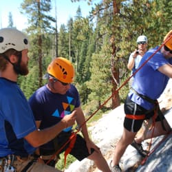
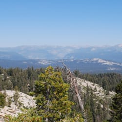
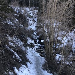
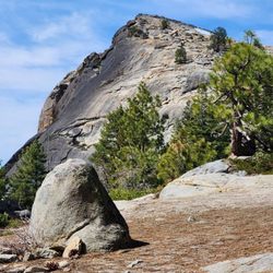
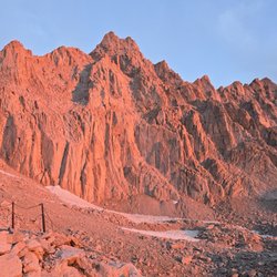
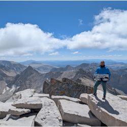
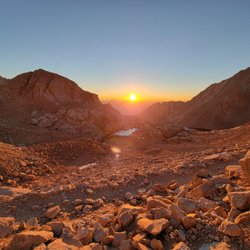
This peak is just outside the town of Lone Pine. It's just shy of 13,000 ft but it's often mistaken for the tallest mountain in the lower 48: Mt Whitney, which lies behind and to the viewer's right of it. If you use an Apple computer, you've probably seen this mountain before. It's the default wallpaper for macOS Sierra. It's also a pretty fun mountain to climb. It's got numerous long 5th class (rock climbing) routes. And it's also got a handful of "walk-up" (hiking) routes (the most popular of which is by the Lake Meysan Trail). I've been up the Lake Meysan route in a day (about 8 hrs RT) and up the North Ridge (about 19 hrs RT) both were incredible days in the hills. The summit area is flat and MASSIVE. It would be easy to camp up here if one were properly prepared. The hiking route is a great option if you can't get a permit for Whitney, permits are much easier for Lone Pine! read more


More info about Lone Pine Peak


Lone Pine Peak - hiking - Updated June 2026
Best of Lone Pine
People found Lone Pine Peak by searching for…
Lakes in Lone Pine, California
Swimming Holes in Lone Pine, California
Hiking Trails in Lone Pine, California
Things to Do in Lone Pine, California
Fishing Spots in Lone Pine, California
Swimming Lakes in Lone Pine, California
Star Gazing in Lone Pine, California
Secret Spots in Lone Pine, California
Stair Climbing in Lone Pine, California
Climbing Gym in Lone Pine, California
White Water Rafting in Lone Pine, California
Playgrounds in Lone Pine, California
Sunset View in Lone Pine, California
Off Road Trails in Lone Pine, California
Bungee Jumping in Lone Pine, California
Gold Panning in Lone Pine, California
Redwood Trees in Lone Pine, California
Lakes & Ponds in Lone Pine, California
Sunrise View in Lone Pine, California
Bouldering Gym in Lone Pine, California
Scenic Overlook in Lone Pine, California
Indoor Rock Climbing Gym in Lone Pine, California
Trending Searches in Lone Pine, CA
Boat Rental near Lone Pine Peak
Fishing Spots near Lone Pine Peak
Off Road Trails near Lone Pine Peak
Public Shower near Lone Pine Peak
River Swimming near Lone Pine Peak
Running Trails near Lone Pine Peak
Strawberry Picking near Lone Pine Peak
Swimming Holes near Lone Pine Peak
Browse Articles
Browse Nearby
Browse Brands
Related Searches in Lone Pine, CA
Best Communal Shower Facilities in Lone Pine, California
Best Fishing Locations and Guides in Lone Pine, California
Best Iyengar Yoga Classes and Studios in Lone Pine, California
Best Nature Trails for Hiking in Lone Pine, California
Best Places for Horseback Riding in Lone Pine, California
Best Sledding Spots and Fun in Lone Pine, California
Best Spots for Star Gazing in Lone Pine, California
Best Waterfalls and Swimming Holes in Lone Pine, California
Browse Yoga Classes and Schedules in Lone Pine, California
Check Out Off Road Trails in Lone Pine, California
Discover Dog Friendly Trails to Explore in Lone Pine, California
Discover Fun Kid Activities to Enjoy in Lone Pine, California
Discover Fun Recreation Activities in Lone Pine, California
Discover Gyms With Steam Room Options in Lone Pine, California
Discover Kids Play Area Spots in Lone Pine, California
Discover Popular Bike Trails in Lone Pine, California
Discover Powerlifting Gym Near Lone Pine, California
Discover Top Nature Parks to Visit in Lone Pine, California
Discover Top Yoga Options and Studios in Lone Pine, California
Discover a Hiking Trail in Lone Pine, California
Discover the Best Night Hike Trails in Lone Pine, California
Dog-Friendly Hikes With Dogs in Lone Pine, California
Enjoy Camping Adventures Around Lone Pine, California
Enjoy Hiking Adventures in Lone Pine, California
Enjoy Kayaking Adventures in Lone Pine, California
Enjoy the Best Bouldering Experiences in Lone Pine, California
Enjoy the Best Walking Trails in Lone Pine, California
Exciting Cliff Jumping Spots in Lone Pine, California
Explore Beautiful Parks and Green Spaces in Lone Pine, California
Explore Easy Hikes Perfect for All in Lone Pine, California
Explore Fun Activities to Do in Lone Pine, California
Explore Popular Campgrounds Near Lone Pine, California
Explore Popular RV Parks Around Lone Pine, California
Explore Popular Scenic Overlook Points in Lone Pine, California
Explore Popular Scenic Views Near Lone Pine, California
Explore Popular Sports Clubs in Lone Pine, California
Explore Popular View Points Around Lone Pine, California
Explore Scenic Lakes to Visit in Lone Pine, California
Explore Top Dog Parks in Lone Pine, California Near You
Explore Top Gyms in Lone Pine, California Now
Explore the Best Boating Spots in Lone Pine, California
Explore the Best Rock Climbing Areas in Lone Pine, California
Explore the Best Swimming Holes Around Lone Pine, California
Explore the Best Trail Options in Lone Pine, California
Family Friendly Hiking With Kids in Lone Pine, California
Find Beautiful Views in Lone Pine, California
Find Beginner Yoga Sessions in Lone Pine, California
Find Fun Kids Activities Outdoor in Lone Pine, California
Find Parks and Recreation Activities in Lone Pine, California