Mobius Arch Loop Trail Photos


More like Mobius Arch Loop Trail
Recommended Reviews - Mobius Arch Loop Trail
Start your review...

Reviews With Photos


Super easy stroll to see some fun views. I did it 7 months pregnant with no issue. Just over a half mile. It was hot so bring water, it's always better to be safe than sorry! Trail was clean. Mount Whitney is as impressive as always. Great to see some tall peaks, Alabama hills, some arches and cacti. You got the best of a lot of worlds. Dog friendly trail - just make sure you clean up!


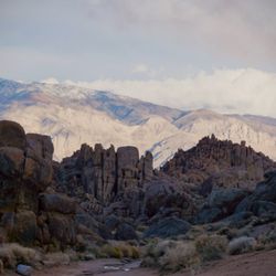
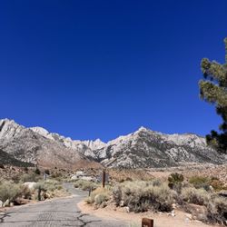
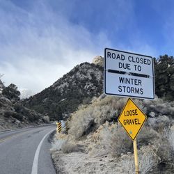
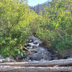
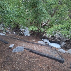
A super short but beautiful hiking trail out to Mobius Arch! This trail also offers views of some unique rock formations and the stunning Mount Whitney! There are several scenic drives that you can take in the Alabama Hills, but the Mobius Arch loop is a great way to get out of the car and explore more of this park on foot. The Mobius Arch trail is a short and easy .6 mile loop. It starts off on a sandy path that takes you through a desert that's filled with the most unique rock formations. Not much incline here but the views are what you're coming from. You'll be able to spot Mobius Arch right away, and it's an arch that you can actually climb on. It's a really beautiful natural arch. You can even see another popular arch from here (the heart arch). Perhaps one of the most beautiful views from this trail is of Mount Whitney. During the winter, the mountain is covered in snow and it's so gorgeous to witness. This is a pretty popular trail and the parking lot is small, so be prepared to come a little early to snag a parking spot. There's a portable restroom near the parking lot here, but there are no other facilities. Make sure to bring your own water because there isn't any. It's that desert life! Also to note: You have to drive down Movie road to access this trail. A 4x4 is highly recommended, but you can still take a regular vehicle if you drive nice and slooooow. The dirt roads are extremely bumpy and rocky. It's about a 1.5 mile drive down Movie road from Whitney Portal Road. Maps of this trail and Alabama Hills Recreation can be accessed at the Eastern Sierra Visitor Center located a few miles before you enter the Alabama Hills. If you're planning on visiting the Alabama Hills, this is an excellent place to stop along your scenic drives.

Wow. I've never heard of Alabama Hills and this trail until a few days ago. We're on our way to Mammoth and decided to stop by here to stretch our legs. What wonderful views and so many boulders to hop and climb on. Definitely worth the stop. Pretty easy and quick walk around the trail (less than 30m). Not too crowded and great shots of the scenery.

Extremely well-maintained trail with beautiful rock formations and the Sierra in the background. Definitlely bring your camera/phone and water. The trail itself is not long (about .6 miles) but can be a bit steep and slippery. Hiking boots recommended. Free parking in the small lot. It's stunning...no wonder so many movies were filmed here!


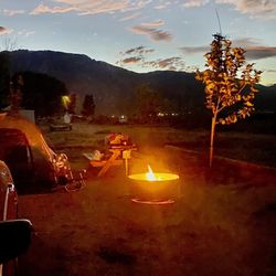
Great place to get away and check out the Mountain View, and camping. Great for kids that like to climb rocks, and check out nature. You do have to drive thru a dirt road but it's not that bad. A couple curves but once you pass MOBIUS Arch. There's a portable restroom but no water so bring sanitizer.

The whole Alabama Hills area seems like an out of place landscape, such interesting formations that seem to have been dropped into an area that it doesn't fit.... and that is what is so amazing about the experience. Within the hills is a great little trail through some of those interesting formations, arches, even a heart in the hills! We loved the topography and all of the interesting rocks. We hiked early on a June morning and took our dog, but he still got very hot, we wouldn't take him again if we went. Be sure to check it out if you are in the area!

The most famous trail here, easy to reach, you can drive up to it. Easy to hike, but use shoes, not sandals or flip-flops, there are a lot of rock climbing opportunities. It's a loop so if you go left you will get to the #MobiusArch quick, but I would start going right and you'll see a lot of nice small trails and funny looking rocks with nice views and flowers before you get to the main attraction.


20 days ago
This is such an absolutely hidden gem. I did. Whitney many years ago and only stayed overnight in lone pine so I didn't get to explore. I went back to explore the Whitney portal area and hike the areas that are accessible. However, this is in February and it was still closed so on my way out I came across Alabama Hills. Oh my gosh so much fun dog friendly and so many amazing sites like the Mobius Arch loop Trail and I got to see this Moon rise the sunset And the next day the sunrise and the moon set and if this was during a full moon so amazing. It was incredible. If you find yourself in the lone pine area or visiting Mount Whitney, you might want to check out this place. Definitely worth exploring. read more


+ Short, beginner-friendly hike. About 1.25 mile, 30 minutes. + Fantastic photo ops with vantages of arches circumscribing Mt Whitney. + Free access and parking. . One or two porta-potties. . Moderately crowded. . Minimal shade. - No water. read more


8 months ago
5 months ago
It was a nice easy family hike that you could take everybody on. We had a lot of fun seeing the natural rock structures. It's such a beauty just being out there. There's free parking and restrooms. First come first serve. read more


Super easy stroll to see some fun views. I did it 7 months pregnant with no issue. Just over a half mile. It was hot so bring water, it's always better to be safe than sorry! Trail was clean. Mount Whitney is as impressive as always. Great to see some tall peaks, Alabama hills, some arches and cacti. You got the best of a lot of worlds. Dog friendly trail - just make sure you clean up! read more


A super short but beautiful hiking trail out to Mobius Arch! This trail also offers views of some unique rock formations and the stunning Mount Whitney! There are several scenic drives that you can take in the Alabama Hills, but the Mobius Arch loop is a great way to get out of the car and explore more of this park on foot. The Mobius Arch trail is a short and easy .6 mile loop. It starts off on a sandy path that takes you through a desert that's filled with the most unique rock formations. Not much incline here but the views are what you're coming from. You'll be able to spot Mobius Arch right away, and it's an arch that you can actually climb on. It's a really beautiful natural arch. You can even see another popular arch from here (the heart arch). Perhaps one of the most beautiful views from this trail is of Mount Whitney. During the winter, the mountain is covered in snow and it's so gorgeous to witness. This is a pretty popular trail and the parking lot is small, so be prepared to come a little early to snag a parking spot. There's a portable restroom near the parking lot here, but there are no other facilities. Make sure to bring your own water because there isn't any. It's that desert life! Also to note: You have to drive down Movie road to access this trail. A 4x4 is highly recommended, but you can still take a regular vehicle if you drive nice and slooooow. The dirt roads are extremely bumpy and rocky. It's about a 1.5 mile drive down Movie road from Whitney Portal Road. Maps of this trail and Alabama Hills Recreation can be accessed at the Eastern Sierra Visitor Center located a few miles before you enter the Alabama Hills. If you're planning on visiting the Alabama Hills, this is an excellent place to stop along your scenic drives. read more


5 years ago
Wow. I've never heard of Alabama Hills and this trail until a few days ago. We're on our way to Mammoth and decided to stop by here to stretch our legs. What wonderful views and so many boulders to hop and climb on. Definitely worth the stop. Pretty easy and quick walk around the trail (less than 30m). Not too crowded and great shots of the scenery. read more


Extremely well-maintained trail with beautiful rock formations and the Sierra in the background. Definitlely bring your camera/phone and water. The trail itself is not long (about .6 miles) but can be a bit steep and slippery. Hiking boots recommended. Free parking in the small lot. It's stunning...no wonder so many movies were filmed here! read more


4 years ago
2 years ago


5 years ago
Great place to get away and check out the Mountain View, and camping. Great for kids that like to climb rocks, and check out nature. You do have to drive thru a dirt road but it's not that bad. A couple curves but once you pass MOBIUS Arch. There's a portable restroom but no water so bring sanitizer. read more


The whole Alabama Hills area seems like an out of place landscape, such interesting formations that seem to have been dropped into an area that it doesn't fit.... and that is what is so amazing about the experience. Within the hills is a great little trail through some of those interesting formations, arches, even a heart in the hills! We loved the topography and all of the interesting rocks. We hiked early on a June morning and took our dog, but he still got very hot, we wouldn't take him again if we went. Be sure to check it out if you are in the area! read more


The most famous trail here, easy to reach, you can drive up to it. Easy to hike, but use shoes, not sandals or flip-flops, there are a lot of rock climbing opportunities. It's a loop so if you go left you will get to the #MobiusArch quick, but I would start going right and you'll see a lot of nice small trails and funny looking rocks with nice views and flowers before you get to the main attraction. read more

5 years ago
Good small hike. Easy to get off trail and wander and explore. Loved it and would do it again when we go back. The whole area in alabama hills is amazing and will be going back in the spring and summer. read more

Mobius Arch Loop is located within the Alabama Hills Recreation area. The rock formation is nothing short of impressive where many movies were filmed such as Iron Man. The Mobius Arch loop has its own little parking lot. If you're in the town of Lone Pine, take Whitney Portal Rd which is paved and turn right (north) on Movie Road. Movie Rd is all dirt and sand and for approx 2 miles the road turns around a huge rock and you can't miss the lot. Once there, there are two trails to get to Mobius Arch. Longer or shorter. The longer is more scenic with rocks and the shorter is less scenic. After you park, the trail to the right of the parking lot is the longer trail and the trail to the left is the shorter one. Follow the dirt path & markings and you'll be there in about 5-10 minutes tops. Great for photos with Mount Whitney clearly in the background as a great photo op. Play around with filters, you'll definitely get great shots. read more


7 years ago
More info about Mobius Arch Loop Trail
Lone Pine, CA 93545
Directions
Hours
Outdoor Amenities
Other Amenities
Ask the Community - Mobius Arch Loop Trail
Review Highlights - Mobius Arch Loop Trail


Mobius Arch Loop Trail - hiking - Updated June 2026
Best of Lone Pine
People found Mobius Arch Loop Trail by searching for…
Things to Do in Lone Pine, California
Hiking Trails in Lone Pine, California
Parks in Lone Pine, California
Public Shower in Lone Pine, California
Off Road Trails in Lone Pine, California
Watch Sunset in Lone Pine, California
Visitor Centers in Lone Pine, California
Attractions in Lone Pine, California
Climbing in Lone Pine, California
Scenic View in Lone Pine, California
Hikes With Dogs in Lone Pine, California
Free Snow Play in Lone Pine, California
Sunset View in Lone Pine, California
Scenic Drive in Lone Pine, California
Camping Sites in Lone Pine, California
Free Parking in Lone Pine, California
Running Trails in Lone Pine, California
Long Term Rv Parking in Lone Pine, California
Free Campgrounds in Lone Pine, California
Photo Spots in Lone Pine, California
Rest Area in Lone Pine, California
Rv Dump Station in Lone Pine, California
Trending Searches in Lone Pine, CA
Boat Rental near Mobius Arch Loop Trail
Fishing Spots near Mobius Arch Loop Trail
Lakes near Mobius Arch Loop Trail
Off Road Trails near Mobius Arch Loop Trail
Public Shower near Mobius Arch Loop Trail
River Swimming near Mobius Arch Loop Trail
Running Trails near Mobius Arch Loop Trail
Rv Campgrounds near Mobius Arch Loop Trail
Strawberry Picking near Mobius Arch Loop Trail
Swimming Holes near Mobius Arch Loop Trail
Browse Articles
Browse Nearby
Browse Brands
Related Cost Guides
Related Searches in Lone Pine, CA
Affordable Long Term RV Parking in Lone Pine, California
Affordable RV Rental Options in Lone Pine, California
Best Communal Shower Facilities in Lone Pine, California
Best Fishing Locations and Guides in Lone Pine, California
Best Iyengar Yoga Classes and Studios in Lone Pine, California
Best Nature Trails for Hiking in Lone Pine, California
Best Places for Horseback Riding in Lone Pine, California
Best RV Dump Stations Available in Lone Pine, California
Best Sledding Spots and Fun in Lone Pine, California
Best Spots for Star Gazing in Lone Pine, California
Browse Charming Cabins in Lone Pine, California
Browse Top Hotels in Lone Pine, California for Your Stay
Browse Yoga Classes and Schedules in Lone Pine, California
Check Out Off Road Trails in Lone Pine, California
Discover Dog Friendly Trails to Explore in Lone Pine, California
Discover Free Campgrounds in Lone Pine, California Area
Discover Gyms With Steam Room Options in Lone Pine, California
Discover Popular Bike Trails in Lone Pine, California
Discover Powerlifting Gym Near Lone Pine, California
Discover Scenic Beach Camping Sites in Lone Pine, California
Discover Top Yoga Options and Studios in Lone Pine, California
Discover a Hiking Trail in Lone Pine, California
Discover the Best Night Hike Trails in Lone Pine, California
Dog-Friendly Hikes With Dogs in Lone Pine, California
Enjoy Camping Adventures Around Lone Pine, California
Enjoy Hiking Adventures in Lone Pine, California
Enjoy Kayaking Adventures in Lone Pine, California
Enjoy RV Camping Adventures in Lone Pine, California
Enjoy a Relaxing Bed & Breakfast Experience in Lone Pine, California
Enjoy the Best Bouldering Experiences in Lone Pine, California
Enjoy the Best Walking Trails in Lone Pine, California
Exciting Cliff Jumping Spots in Lone Pine, California
Explore Beautiful Parks and Green Spaces in Lone Pine, California
Explore Easy Hikes Perfect for All in Lone Pine, California
Explore Fun Activities to Do in Lone Pine, California
Explore Hotels & Travel Options in Lone Pine, California
Explore Mobile Home Parks in Lone Pine, California Now
Explore Popular Campgrounds Near Lone Pine, California
Explore Popular Picnic Areas Around Lone Pine, California
Explore Popular RV Parks Around Lone Pine, California
Explore Scenic Lakes to Visit in Lone Pine, California
Explore Top Dog Parks in Lone Pine, California Near You
Explore the Best Boating Spots in Lone Pine, California
Explore the Best Swimming Holes Around Lone Pine, California
Explore the Best Trail Options in Lone Pine, California
Family Friendly Hiking With Kids in Lone Pine, California
Find Beautiful Views in Lone Pine, California
Find Beginner Yoga Sessions in Lone Pine, California