Lamarck Lakes Photos


More like Lamarck Lakes
Recommended Reviews - Lamarck Lakes
Start your review...

7 years ago
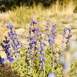
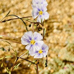
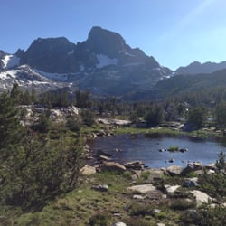
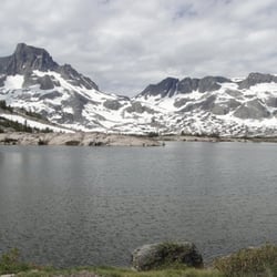
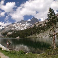
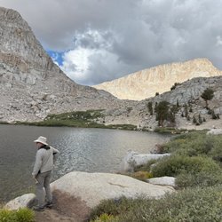
A 6.8-mile roundtrip hike to another fantastic chain of Sierra mountain lakes. The street to the trailhead is located between Aspendell and Lake Sabrina. The steep access road is a 2-miles long, mostly unpaved, and one-lane wide. Like with hiking, vehicles coming down the hillside must yield to cars coming up (which rudely did not occur). The road passes the boring North Lake. The trailhead technically is at the North Lake campground, but hikers are not allowed to park there. From the trailhead, Lamarck Lakes are southwest but a second trail goes westward to Piute Pass past Loch Leven and Piute Lake. A sign directs to either location. Starting at the North Lake day use parking lot at 9200' above sea level, the easy-to-follow trail goes to 1.8-miles one-way and up 650' to Grass Lake - so called due to its marshy green appearance (see pic) which is atypical of Sierra lakes. Grass Lake is on a short and fairly flat side spur from the main trail that is clearly marked. At 2.4 miles and 1400' up the trail from the parking lot is Lower Lamarck Lake at 10,600'. Resting below Mt. George Davis this is the best lake of the four and the best part of the hike (see pic) and bound to leave a lasting Lamarck on la mind. At 3.2 miles and 1600' from the parking lot is Upper Lamarck Lake which has little vegetation and mainly surrounded by rock piles. It's still worth trekking to the final lake because the alpine stream connecting Lower and Upper was the second best sight of the hike. read more


More info about Lamarck Lakes


Lamarck Lakes - hiking - Updated June 2026
Best of Bishop
People found Lamarck Lakes by searching for…
Things to Do in Bishop, California
Hiking Trails in Bishop, California
Swimming Holes in Bishop, California
Easy Hikes in Bishop, California
Off Road Trails in Bishop, California
Public Pools in Bishop, California
Public Shower in Bishop, California
Star Gazing in Bishop, California
Golf Course in Bishop, California
Fitness & Instruction in Bishop, California
National Parks in Bishop, California
Ghost Towns in Bishop, California
Park & Forests in Bishop, California
View Points in Bishop, California
Must See in Bishop, California
Swimming Lakes in Bishop, California
Scenic View in Bishop, California
Lakes & Ponds in Bishop, California
Trending Searches in Bishop, CA
Boat Rental near Lamarck Lakes
Cliff Jumping near Lamarck Lakes
Dog Friendly Trails near Lamarck Lakes
Fishing Spots near Lamarck Lakes
Kayak Rental near Lamarck Lakes
Lakes & Ponds near Lamarck Lakes
Off Road Trails near Lamarck Lakes
Public Pools near Lamarck Lakes
Public Shower near Lamarck Lakes
River Swimming near Lamarck Lakes
River Tubing near Lamarck Lakes
Swimming Holes near Lamarck Lakes
Swimming Lakes near Lamarck Lakes
Browse Articles
Browse Brands
Related Searches in Bishop, CA
Affordable Kayak Rental Services in Bishop, California
Best Fishing Locations and Guides in Bishop, California
Best Fun Things to Do in Bishop, California
Best Places for Horseback Riding in Bishop, California
Best Sledding Spots and Fun in Bishop, California
Best Spots for Star Gazing in Bishop, California
Check Out Off Road Trails in Bishop, California
Discover Dog Friendly Trails to Explore in Bishop, California
Discover a Hiking Trail in Bishop, California
Discover the Best Night Hike Trails in Bishop, California
Dog-Friendly Hikes With Dogs in Bishop, California
Enjoy Camping Adventures Around Bishop, California
Enjoy Exciting Mountain Biking Adventures in Bishop, California
Enjoy Kayaking Adventures in Bishop, California
Enjoy Tent Camping Spots Around Bishop, California
Enjoy the Best Tubing Experiences in Bishop, California
Enjoy the Best Walking Trails in Bishop, California
Exciting Cliff Jumping Spots in Bishop, California
Experience Stunning Sunset Views in Bishop, California
Explore Beautiful Parks and Green Spaces in Bishop, California
Explore Bike Rentals Throughout Bishop, California
Explore Fun Activities to Do in Bishop, California
Explore Popular Campgrounds Near Bishop, California
Explore Popular RV Parks Around Bishop, California
Explore Scenic Lakes to Visit in Bishop, California
Explore Top Dog Parks in Bishop, California Near You
Explore the Best Boating Spots in Bishop, California
Explore the Best Swimming Holes Around Bishop, California
Family Friendly Hiking With Kids in Bishop, California
Find Cozy Camping Cabins in Bishop, California
Find Top Dog Swimming Spots in Bishop, California
Find the Best Playgrounds to Visit in Bishop, California
Find the Best Scenic View Locations in Bishop, California
Hiking Trails With Waterfalls in Bishop, California
Off Leash Dog Hiking Trails in Bishop, California
Plan a Scenic Drive Route Near Bishop, California
Popular Fishing Spots to Explore in Bishop, California
Popular Picnic Spots to Visit in Bishop, California
Popular Things to Do in Bishop, California
Popular Things to See in Bishop, California
Safe River Swimming Areas in Bishop, California
Safe and Fun Parks for Kids in Bishop, California
Top Climbing Spots and Gyms in Bishop, California
Top Paddleboarding Activities in Bishop, California
Top Playgrounds for Kids to Enjoy in Bishop, California
Top Running Trails to Explore in Bishop, California
Top Swimming Lakes to Enjoy in Bishop, California
Top Swimming Spots and Pools in Bishop, California