Cancel

    Open app

    Search

    Andrews Recreation Park

    5.0 (2 reviews)

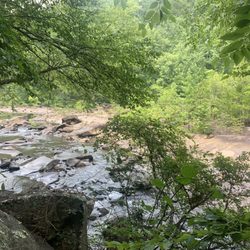
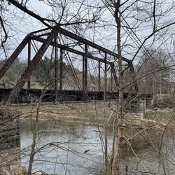
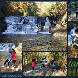
    Andrews Recreation Park Photos

    More like Andrews Recreation Park

    Recommended Reviews - Andrews Recreation Park

    Your trust is our priority, so businesses can't pay to alter or remove their reviews. Learn more about reviews.
    Yelp app icon
    Browse more easily on the app
    Review Feed Illustration

    8 years ago

    This is a beautiful and very clean rest stop. No overnight parking, but a great place to stretch your legs.

    Helpful 0
    Thanks 0
    Love this 0
    Oh no 0

    5 years ago

    Very nice park with a pool, ball fields etc. Well maintained and a nice spot to visit

    Helpful 0
    Thanks 0
    Love this 0
    Oh no 0

    Verify this business for free

    People searched for Parks 115 times last month within 15 miles of this business.

    Verify this business

    Riley Moore Falls

    Riley Moore Falls

    5.0(4 reviews)
    48.8 mi

    This is the best waterfall we got to visit in SC this far. After we left Reedy Branch Falls we…read moredrove here. Well, as close as we could get. I didn't realize that we couldn't drive all the way to the trailhead so we had a long hike in store due to me having to carry my toddler most of the time. I should have re-read the previous reviews before coming. My friend did help me carry her as well and for that I was very thankful. So definitely don't recommend this hike with a little one unless strapped in a carrier. Also, I don't recommend it for the elderly either. It's definitely a wilderness hike deal with roots and elevation change. In fact, it's mostly downhill on the way to the falls, but on the way back it's pretty much all uphill, which was not fun with aforementioned young child. It's about a half mile to the actual trailhead and then another 0.7 mile to the falls. That's about 2.4 miles round trip. The reason of course that my boys absolutely became enamored with this place is the large swimming hole. It is wonderful and has plenty of space. The waterfall itself is beautiful and although it's not as tall as others, its width is quite impressive. I was trying to get as close as I could and even noticed a hidden part of the falls inside of the rock structure. That was so cool!! The sand at the base and shore give it a beachy vibe. We definitely packed it in and out making sure not to leave anything behind as to preserve the area as best as possible. Needless to say we were wiped by the time we made it back to our vehicles, but we're still glad we decided to venture here. Coming back with my hubby and boys in the very near future. Happy yelping!

    I just wanted to update my 3/15/20 review below to add I've now done this hike several times, but…read moreTHIS time I had the chance to hike it with a friend who is directly related to the namesake of the waterfall... Riley Moore. Sandie is a church friend of mine and Riley Moore was her Great Great Uncle (I believe that's right). He once upon a time operated a grist mill here at the top of the falls. She's been trying to get here to see the waterfall, but couldn't find it and wanted to join us (along with her family) since I knew the way. Upon further research I discovered there are actually still remnants of the mill including visible drill holes, spikes and bolts. Thought that was pretty cool info to share! [ [ [ PREVIOUS REVIEW ] ] ] Riley Moore Falls is small in height but HUGE in personality. It's located off State Road S37-748, which is a nicely maintained gravel road where cars and trucks alike can comfortably traverse. ~~~ DIRECTIONS From Westminster, SC - DO NOT turn onto Cobb Bridge Road from Long Creek Hwy (Hwy 76) where you will see the brown & white sign pointing you in the direction of Riley Moore Falls. Our GPS had us go this way, then left onto State Road S37-748, but the road was CLOSED during our visit! INSTEAD, turn onto PU-32 also known as Rocky Fork Road. Turn left onto a gravel road near Rocky Fork Baptist Church and follow that until it dead ends @ State Road S37-748 (also known as Spy Rock Road). Turn right and drive approx. 1.4 miles (4 minutes) to 748c (aka Riley Moore Shoals Road). Park at the intersection of State Road S37-748 and 748c. DO NOT ATTEMPT TO DRIVE 748c in a car or minivan. Low clearance vehicles will find the terrain on this road to be VERY difficult to navigate without bottoming out or getting stuck. I'd also recommend 4x4 capability on wet days! There can be several deep-pocketed muddy areas after heavy rains. ~~~ THE TRAIL Once you reach the intersection of Spy Rock Rd (S37-748) and 748c, park roadside on Spy Rock, secure your vehicle and begin your hike approx. 1/2 mile down the "primitive road." IF you have a high ground clearance SUV or truck, you can drive the primitive road another half mile or so to a second parking area near the trailhead. The primitive road is VERY BUMPY  and can be muddy in spots after heavy rains, so a 4x4 is best. After reaching the second parking area, follow the marked trail on the left!!! The trail is a little over a 1/2 mile to the falls from here. The trail is fairly straightforward and easy to follow. ~~~ THE FALLS Once you reach the Chauga River, you will notice a large sandy area with plenty of room for an entire horde of hikers!!! Riley Moore Falls is not very tall (only about 12 feet), but it is very wide and has a deep base pool. PRO TIP - Bring swimwear, towels and a picnic, but be sure to pack it in and pack it out. ~~~ THINGS TO KNOW Hiking Distance: 2 miles (round trip to falls from S37-748) Difficulty of hiking 748c: All downhill to trailhead (moderate return) Difficulty of hiking trail to falls: EASY Creek Crossings: NO Elevation Gain: 357 feet Waterfall Height: Approx 12 feet Access to top of falls: NO - not without getting wet Access to base of falls: YES Pool of water @ base of Falls: YES Sitting areas @ base: YES + sandy beach RESTROOMS: NO PARKING: YES (along road) + secondary parking area closer to trailhead for trucks and high ground clearance vehicles with room for about 6 cars. ~~~ [ FINAL THOUGHTS ] A lovely waterfall in any season, but also a great spot for a summer swim. While we had the waterfall practically to ourselves during our Mid-March expedition, be advised other trail website reviews say it gets trashy & crowded in summer months. What a shame if that is true because it truly is a treasure. ENJOY! 2022 / 74 #UPDATE 178

    Photos
    Riley Moore Falls
    Riley Moore Falls - CREATED FROM GOOGLE MAPS

    CREATED FROM GOOGLE MAPS

    Riley Moore Falls

    See all

    The Sinks - The Sinks in its glory.

    The Sinks

    4.9(37 reviews)
    33.7 mi

    I never met a waterfall that I didn't like. We did a driving tour along Little River in Great Smoky…read moreMountains National Park to see if we could spot some wildlife. The Sinks is a lovely waterfall along the river. There is a small parking lot with about a dozen spaces where we found parking. An observation area is a short walk from parking. A sign describes the area and that the falls were manmade. During the late 1800's the river was used to transport logs/timber to the nearby town of Elkmont. After a storm, flood waters caused a jam in the river. Dynamite was used to restore water flow. The blast resulted in a twist in the river and creation of the waterfall. A set of stone steps leads up a hill, offering lovey views of the falls. There are dozens of waterfalls in the Park. Sinks is one of the few that is drivable, which is great for people that cannot hike. I picked up a Waterfalls map at the visitor center that I found interesting and informative. Parking passes are required to park in the lot. There are no amenities at the falls. Plan 15-30 minutes for a stop and photos.

    The Sinks is such a fun outdoor experience! Our boys, ages 11 & 13, loved it! The parking is not…read moregreat though, with only about 15 spots in the parking lot and nowhere else to go. It's super busy in the summer, so just be prepared for that. We had to wait about 15 minutes for someone to leave so we could park. That wouldn't keep us from going back, though.

    Photos
    The Sinks
    The Sinks - Observation patio

    Observation patio

    The Sinks - View from path to the platform.

    See all

    View from path to the platform.

    Murphy River Walk - Sign that warns about wild life in the area

    Murphy River Walk

    4.2(17 reviews)
    13.7 mi

    The attraction of this downtown is a network of trails and boardwalks which offer views of the…read moreriver. It's a quiet mountainous area, and while the aesthetics aren't what you'd get at some of the really primo tourist attractions, it is a pleasant and relaxing piece of nature. The upkeep of the infrastructure varied dramatically; some boardwalks looked quite new, while another platform was falling apart. I was on parts of the trails for the better part of an hour but I'm sure there was plenty more that I didn't get to. It is an area that has something to offer regardless of the season, and while I'd rather hit one of the big parks nearby, it was a nice place to spend a little time when I did.

    For all you people driving purposefully through the NC mountains, as you drop into Murphy, don't…read moremiss the Murphy River Walk. Easy parking near downtown (I guess it's downtown at least it's town), take a sea-level stroll beside the river while breathing in the surroundings. An extra star for those black walnut trees dropping their wares on the path because we all need more walnuts in our lives. Add in some nice level paths for strolling and it's a fun trip. Allow 30 mins at least, take much longer if you want to enjoy the many twists and turns under the trees. Venture across the walking bridge to the other side of you date challenge the seasoned pros to a pickle match. We didn't dare on this trip since we'd already braved the Sasquatch. I hope to return for another stroll when in the big city again.

    Photos
    Murphy River Walk
    Murphy River Walk
    Murphy River Walk

    See all

    Great Smoky Mountains National Park - Mushroom

    Great Smoky Mountains National Park

    4.7(430 reviews)
    37.5 mi

    Stunning. The Great…read moreSmoky Mountains National Park officially ties with Yosemite as my two favorite national parks in the US. I love everything about this beautiful area of our country. We were there in early spring and enjoyed stunning weather, blooming wild flowers, and bear sightings a-plenty. We also were there when the dogwoods were blooming and there are dogwood trees throughout the park--it was stunning. We enjoyed driving around the park, hiking, and stopping at various points of interest. We were also able to take an accessible hike up a paved trail to the highest point in the park, which was amazing. My eyes seriously just could not get enough of all the gorgeous nature to be enjoyed here. Top notch. Get to it!

    Great Smoky Mountain National Park has been on my bucket list for many years. I was hoping that…read morespring break would be down season at the Park, but the Park was busy!!! We had a fabulous visit to this vast natural wonder. We learned that Park is the largest natural habitat in the continental U.S. The signature "smoky" appearance of the mountains is caused by an evaporation of organic rich moisture released by the vegetation within the Park. We started our visit by stopping at the visitors center to pick up a parking permit ($5/day) and maps ($1). I was glad we picked up maps because there is very little internet connectivity in the park, so we lost our navigation tools. The leaves were not on the trees yet (April) so we had magnificent uninterrupted views of the mountains and skylines. Spring wild flowers were in bloom. And we actually saw a mother bear with two cubs crossing the road. Each day during our visit we explored a different part of the park. We hiked to waterfalls and enjoyed scenic overlooks. We enjoyed exploring historic cabins and cemeteries. Popular sites were crowded and sometimes we had to wait for parking. Plan to arrive early. The park is filled with parking areas to pull off and enjoy the views or hike. Rest areas are available at many of the major sites. Leased dogs are only allowed in camping and parking areas and on two of the many trails. Bring good walking shoes, a hiking stick is helpful, water and sun glasses. You probably need to bring snacks, but keep those secure from wildlife.

    Photos
    Great Smoky Mountains National Park - Babbling brooks

    Babbling brooks

    Great Smoky Mountains National Park
    Great Smoky Mountains National Park - Sugarlands Visitor Center

    See all

    Sugarlands Visitor Center

    Tallulah Gorge State Park

    Tallulah Gorge State Park

    4.5(209 reviews)
    40.2 mi

    Tallulah Gorge State Park is a 2,689-acre Georgia state park adjacent to Tallulah Falls, Georgia,…read morealong the county line between Rabun and Habersham Counties. The park surrounds Tallulah Gorge, a 1,000-foot deep gorge formed by the action of the Tallulah River, which runs along the floor of the gorge. Service options here are picnic tables available, has barbecue grill and it's dogs friendly. One of the most spectacular canyons in the eastern U.S., Tallulah Gorge is two miles long and nearly 1,000 feet deep. Visitors can hike rim trails to several overlooks, or they can obtain a permit to hike to the gorge floor (100 per day, not available during water releases). A suspension bridge sways 80 feet above the rocky bottom, providing spectacular views of the river and waterfalls. $5 parking fee or an Annual ParkPass is required for each vehicle. The park offers a range of trails, from easy rim walks to the more challenging trek down into the gorge floor. Permits are required for gorge floor access, but the effort is well worth it as you can get up close to the waterfalls, including the famous Hurricane Falls. Approximately 2 miles, round-trip Mulched with metal stairs, Rated difficult. This trail has a total of 1,099 stairs (including staircase to gorge floor). Please do not attempt this trail if you have any known health condition. The North and South Rim Trails consist of 3 miles round- trip which will take approximately 2 hours to hike. It is a mulched trail with exposed roots that is a leisurely walk. From the Interpretive Center there is a recycled rubber tire trail that accesses Overlooks 2 and 3. Overall had a great experience.

    The visitor center is phenomenal! Movie was down for some reason. The gift shop has loads to choose…read morefrom and the rest rooms were clean and there were many stalls available. There is almost a museum quality to the taxidermy animal scene they have in the middle of the room and along the walls. Truly a special visit! The hike to see the inspirational point and the swinging bridge wasn't too strenuous for my 4 or 5 year old for people's reference when considering it. We are an active family who hikes etc. There were a lot of warnings but we found it wasn't as bad as it seemed.

    Photos
    Tallulah Gorge State Park
    Tallulah Gorge State Park - 10.22 towards the S Rim 568 stairs up

    10.22 towards the S Rim 568 stairs up

    Tallulah Gorge State Park

    See all

    Andrews Recreation Park - parks - Updated May 2026

    Loading...
    Loading...
    Loading...