Alsea Falls Recreation Site Photos


More like Alsea Falls Recreation Site
Recommended Reviews - Alsea Falls Recreation Site
Start your review...

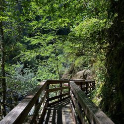
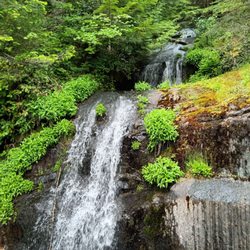
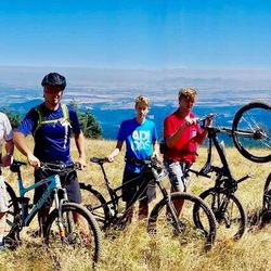
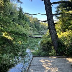
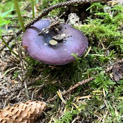
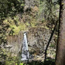
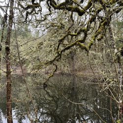
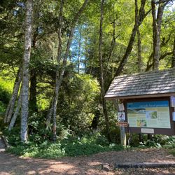
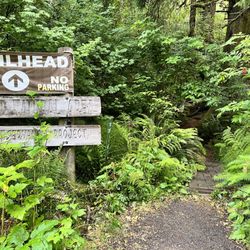
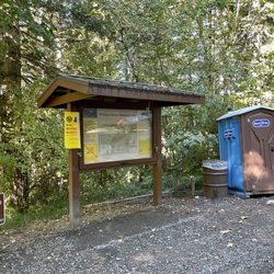
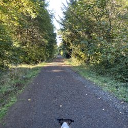
I'll be up front. I love Oregon. I love how beautiful it is here. I love the slower pace of life. I love the food. I love that people here have manners. Actual manners! Sh*t, I haven't experienced anything like this since living in New England (shoutout to NH, VT, and ME). But I digress. Dealing with folks takes a toll on me so I knew I wanted to grab a couple close friends and find a serene spot in a forest somewhere to recharge my batteries. Oregon delivered as usual. Alsea Falls Recreation Site (AFRS) is a picturesque area located 30 minutes southwest of Corvallis and boasts gorgeous forests of red cedars, maples, and Douglas firs as well as two waterfalls. I thought hiking trails here were pleasant. They offer plenty of shade and aren't very strenuous. Alsea Falls is located rather close to the day use parking lot, but there is a 1.4 mile trail leading to Green Peak Falls if you walk across the wooden bridge. The trail is poorly marked so you may lose it when you end up at McBee Park campground. Stick to the right and you will find two trails. Take the right official trail with the trail post. The left trail is shorter but there are stinging nettles along the way. Green Peak is the larger of the two falls and it is possible to climb to the top via the adjacent trail (right side), but it is steep so be careful. O T H E R I N F O -Day use parking is $3. Fill out an envelope. Drop off the envelope with payment in the receptacle across from the outhouse. Keep the stub in your vehicle. -Amenities within the campground include drinking water and vault toilets. Several campsites can accommodate large RVs or trailers; up to 32 feet long. -Dogs are allowed on a leash so bring the family pup along! -Salmon and steelhead fishing during the winter months. -The park is clean. Keep it that way and pack your trash until you find a rubbish bin. -Pack a camera. Take plenty of photos. Collect memories instead of things. read more


More info about Alsea Falls Recreation Site
Alsea, OR 97324
Directions
(503) 375-5646
Call Now
Visit Website
http://www.recreation.gov/camping/campgrounds/255205
Hours
Indoor Amenities
Outdoor Amenities
Other Amenities


Alsea Falls Recreation Site - hiking - Updated June 2026
Best of Alsea
People found Alsea Falls Recreation Site by searching for…
Hiking Trails With Waterfalls in Alsea, Oregon
Dog Friendly Hiking Trails in Alsea, Oregon
River Swimming in Alsea, Oregon
Camping Sites in Alsea, Oregon
Swimming Lakes in Alsea, Oregon
Scenic Overlook in Alsea, Oregon
Dog Friendly Parks in Alsea, Oregon
Public Shower in Alsea, Oregon
Browse Articles
Browse Brands
Related Cost Guides
Related Searches in Alsea, OR
Browse Top Hotels in Alsea, Oregon for Your Stay
Browse Vacation Rentals to Book in Alsea, Oregon
Discover the Best Running Track in Alsea, Oregon
Enjoy a Relaxing Bed & Breakfast Experience in Alsea, Oregon
Explore Beautiful Parks and Green Spaces in Alsea, Oregon
Explore Hotels & Travel Options in Alsea, Oregon
Explore Popular Boat Charters Near Alsea, Oregon
Find Cozy Camping Cabins in Alsea, Oregon
Trending Searches in Alsea, OR
Boat Rental near Alsea Falls Recreation Site
Cliff Jumping near Alsea Falls Recreation Site
Crabbing Location near Alsea Falls Recreation Site
Fireworks near Alsea Falls Recreation Site
Fishing Spots near Alsea Falls Recreation Site
Indoor Bounce House near Alsea Falls Recreation Site
Kayak Rental near Alsea Falls Recreation Site
Kids Activities Indoor near Alsea Falls Recreation Site
Lakes near Alsea Falls Recreation Site
Long Term Rv Parking near Alsea Falls Recreation Site
Nature Parks near Alsea Falls Recreation Site
Peach Picking near Alsea Falls Recreation Site
Playgrounds near Alsea Falls Recreation Site
Public Pools near Alsea Falls Recreation Site
Public Shower near Alsea Falls Recreation Site
River Swimming near Alsea Falls Recreation Site
Rock Quarry near Alsea Falls Recreation Site
Scenic Night View near Alsea Falls Recreation Site
Scenic Overlook near Alsea Falls Recreation Site
Soccer Fields near Alsea Falls Recreation Site
Soccer Store near Alsea Falls Recreation Site
Splash Pad near Alsea Falls Recreation Site
Strawberry Picking near Alsea Falls Recreation Site
Sunrise View near Alsea Falls Recreation Site
Swimming Holes near Alsea Falls Recreation Site
Swimming Lakes near Alsea Falls Recreation Site
Tennis Courts near Alsea Falls Recreation Site