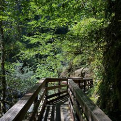
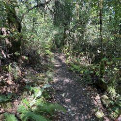
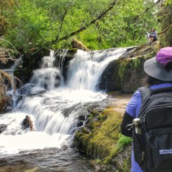
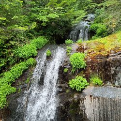
Futton Green Nature trail Photos


More like Futton Green Nature trail
Recommended Reviews - Futton Green Nature trail
Start your review...

2 years ago
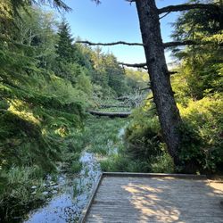
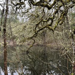
One of our favorite places to visit. Fantastic views and not far from outside of Corvallis. read more


Great hidden hiking gem of Corvallis. Nice views, dogs allowed on leash, not crowded, and bathrooms available. Limited parking, extra parking located at the trail entrance if the parking lot is full. Trail does have a moderate incline/decline. read more


I loved this hike. The views are spectacular. It's dog friendly and the tail is easy. Lots of old oak trees that are great for climbing. It's also 1000 feet in elevation so a little cooler.not much parking so come early. read more


More info about Futton Green Nature trail
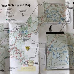
33723 Marys River Estates Rd
Philomath, OR 97370
Directions
Hours
Indoor Amenities
Outdoor Amenities


Futton Green Nature trail - hiking - Updated July 2026
Best of Philomath
People found Futton Green Nature trail by searching for…
Secret Spots in Philomath, Oregon
Hiking Trails in Philomath, Oregon
Dog Friendly Hiking Trails in Philomath, Oregon
Fun Things to Do in Philomath, Oregon
Easy Hikes in Philomath, Oregon
Beautiful Views in Philomath, Oregon
Walking Trails in Philomath, Oregon
Hikes With Dogs in Philomath, Oregon
Free Things to Do in Philomath, Oregon
Off Leash Dog Hiking Trails in Philomath, Oregon
Secluded Spots in Philomath, Oregon
Running Trails in Philomath, Oregon
View Points in Philomath, Oregon
Off Road Trails in Philomath, Oregon
Dog Friendly in Philomath, Oregon
River Swimming in Philomath, Oregon
Things to Do at Night in Philomath, Oregon
Fun Things to Do on a Friday Night in Philomath, Oregon
Swimming Holes in Philomath, Oregon
Scenic Views in Philomath, Oregon
Night Hike in Philomath, Oregon
Swimming Lakes in Philomath, Oregon
Trending Searches in Philomath, OR
4th Of July Fireworks near Futton Green Nature trail
Boat Rental near Futton Green Nature trail
Cliff Jumping near Futton Green Nature trail
Fireworks near Futton Green Nature trail
Kayak Rental near Futton Green Nature trail
Parks For Picnics near Futton Green Nature trail
Places To Swim near Futton Green Nature trail
Public Pools near Futton Green Nature trail
Public Shower near Futton Green Nature trail
River Swimming near Futton Green Nature trail
Rock Quarry near Futton Green Nature trail
Scenic Night View near Futton Green Nature trail
Scenic Overlook near Futton Green Nature trail
Soccer Store near Futton Green Nature trail
Splash Pad near Futton Green Nature trail
Strawberry Picking near Futton Green Nature trail
Sunrise View near Futton Green Nature trail
Swimming Holes near Futton Green Nature trail
Swimming Lakes near Futton Green Nature trail
U Pick Farms near Futton Green Nature trail
Watch Sunset near Futton Green Nature trail
Browse Articles
Browse Nearby
Browse Brands
Related Searches in Philomath, OR
Affordable Kayak Rental Services in Philomath, Oregon
Best Fishing Locations and Guides in Philomath, Oregon
Best Places for Horseback Riding in Philomath, Oregon
Check Out Off Road Trails in Philomath, Oregon
Discover Dog Friendly Trails to Explore in Philomath, Oregon
Discover Top Nature Parks to Visit in Philomath, Oregon
Discover a Hiking Trail in Philomath, Oregon
Discover the Best Night Hike Trails in Philomath, Oregon
Dog-Friendly Hikes With Dogs in Philomath, Oregon
Enjoy Camping Adventures Around Philomath, Oregon
Enjoy Exciting Mountain Biking Adventures in Philomath, Oregon
Enjoy Tent Camping Spots Around Philomath, Oregon
Enjoy a Beautiful Waterfall Hike in Philomath, Oregon
Enjoy the Best Walking Trails in Philomath, Oregon
Exciting Cliff Jumping Spots in Philomath, Oregon
Explore Beautiful Parks and Green Spaces in Philomath, Oregon
Explore Bike Rentals Throughout Philomath, Oregon
Explore Fun Activities to Do in Philomath, Oregon
Explore Nature Spots Around Philomath, Oregon
Explore Popular Campgrounds Near Philomath, Oregon
Explore Popular RV Parks Around Philomath, Oregon
Explore Popular Scenic Overlook Points in Philomath, Oregon
Explore Popular View Points Around Philomath, Oregon
Explore Scenic Lakes to Visit in Philomath, Oregon
Explore Top Dog Parks in Philomath, Oregon Near You
Explore Top Water Parks in Philomath, Oregon Today
Explore Whale Watching Tours in Philomath, Oregon
Explore the Best Boating Spots in Philomath, Oregon
Explore the Best Swimming Holes Around Philomath, Oregon
Family Friendly Hiking With Kids in Philomath, Oregon
Find Popular Ziplining Spots Around Philomath, Oregon
Find the Best Parks for Picnics in Philomath, Oregon
Find the Best Playgrounds to Visit in Philomath, Oregon
Find the Best Scenic View Locations in Philomath, Oregon
Hiking Trails With Waterfalls in Philomath, Oregon
Off Leash Dog Hiking Trails in Philomath, Oregon
Plan a Scenic Drive Route Near Philomath, Oregon
Popular Kids Activities in Philomath, Oregon
Popular Outdoor Activities to Try in Philomath, Oregon
Popular Picnic Spots to Visit in Philomath, Oregon
Popular Things to Do in Philomath, Oregon
Safe River Swimming Areas in Philomath, Oregon
Safe and Fun Parks for Kids in Philomath, Oregon
Top Paddleboarding Activities in Philomath, Oregon
Top Playgrounds for Kids to Enjoy in Philomath, Oregon
Top Running Trails to Explore in Philomath, Oregon
Top Swimming Lakes to Enjoy in Philomath, Oregon
Top Swimming Spots and Pools in Philomath, Oregon