Abiqua Falls Trailhead Photos


You might also consider
More like Abiqua Falls Trailhead
Recommended Reviews - Abiqua Falls Trailhead
Start your review...

Reviews With Photos

This is a pretty great hike, but it can be hard to find. Google maps leads you to the wrong place. I have a Honda Civic that couldn't handle the insane gravel steep road, so I parked about a mile up from the trailhead. I encountered many other hikers who were lost. Once you get to the trail, it is VERY steep, but it is only half a mile to the falls. Bring water shoes if you want to swim since it's very rocky and painful!

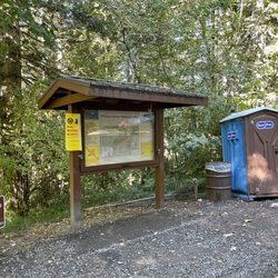
Abiqua is probably one of my favorite landscapes in Oregon. The trail itself isn't as beautiful as other trails in the PNW, but the destination and waterfall at the end is probably one of the best views. I've done this hike 4-5 times now, and fall in a trance in the beauty of the waterfall with the surrounding basalt columns. Be careful using Google maps to get to the trail. I've tried going this route but as I get closer to the destination point, I use my best judgement on where to park. I parked in this dirt area with mounts of dirt and rock piled around. My car is lower, but some cars drive down a little more to park closer to the trailhead in inlets along the pathway (do this at your own risk!). From where I parked, a hike down the slope that curls and curves around for about 30-40 minutes gets me to the trailhead (see picture with sign posted). From there, you're probably about 20 minutes away from the destination. Lots more lush green fauna in this area. Now, the are two sections that can feel quite steep, but there's rope tied down to grasp for balance. The second section is much more steep, but my parents who are not hikers were able to do it fine. After trekking down the second section of steep/rope, you follow the creek (turn left at bottom of the rope) for about 5 minutes and you'll turn a slight curve to see the glorious and magnificent waterfall. Enjoy!

It's a fun and petty hike. The google maps mark you very far away from the trail head. You will have to drive down much further then you think on a little dirt road. Four wheel drive is suggested. Once on the trail it is a little steep at a few points but there are ropes to help keep your balance. The ropes help with the climb out as well. I recommend the hike and it was a lot of fun.

Ok, it's not that hard to find this trailhead, just know where you're going. And drive a truck or suv or high profile cross over, as long as you're slow and careful you can drive to the end of the trail and easily turn around to get out. Every time I've gone, I've drove all the way, in 2 wheel drive truck, believe me, the hike is short but steep enough to kick your butt, you wouldn't want to then walk up a road even further to your vehicle. The hike is pretty but short. Very steep & can be slippery in the spring. Summer the fall doesn't flow as full, you can walk through the creek up and back, it's comfortable and shallow enough in the summer. Very much worth the treck, it's a canyon with a tall waterfall. And you can swim. And fish down stream. It's great.

The trailhead was honestly not hard to find! Me and my girls went there in a tiny Mazda 2W drive and was able to make it down a mile away from the trailhead. The hike is only .8 miles from the trailhead. Well marked and def worth it. It is a bit steep coming back up but not death. The water was cold but bearable and refreshing in the heat. We hitched a ride in the back of a guy's truck so we didn't have to walk another mile to our car

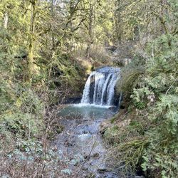
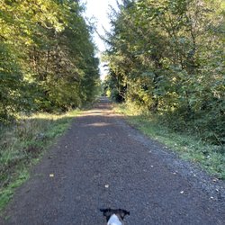
Abiqua Falls! I just visited this beautiful 92-foot waterfall sort of in the middle of nowhere in Oregon but located about 50 miles south of Portland. I have a lot to relay about the experience. This review could take the maximum 5000 words, lol, but I'll try my best to keep things as concise as possible... There are many questions about what to expect from Abiqua Falls. Even myself, I had concerns and doubts. But...I survived and it's an easy adventure to a very secluded waterfall. I'll try and answer the following questions... - Can you drive to the trailhead? From my POV, it's a VERY ROUGH ROAD down to the bottom. There's one specific section (and you'll recognize it immediately) where the road is practically cracked in half with divots and potholes. I actually witnessed a Ford Explorer trying to drive over it on the way back up and it was a big struggle for them! They eventually got past it, but I thought they were stuck. You absolutely need a high clearance 4x4 vehicle to make it down to the base to access the trailhead to Abiqua Falls. For me...I have a Suburu and I parked 2 miles away at the Abiqua Falls "Parking Lot" (according to Google) and then walked 2 miles down to the bottom and 2 miles back up. There was no way I was risking a flat tire, especially with not knowing how to change a tire and there barely being cell phone reception in the area. Btw...just to arrive at the Abiqua Falls parking lot, you must first drive 1.5 miles on a dirt road. For me, dirt and gravel roads are like nails on a chalkboard. I cringe driving over them. - Where is the trailhead located? This is a good question because there's no specific sign for Abiqua Falls, but it's easy to discover. Here's how...the road down to the bottom only goes so far. Eventually, you'll confront a white fence where you can leave your car (if you drove). But...there's a clear opening to the forest on the left-hand side of the road as you're going down. People say it's hard to find, but truly...you can't miss it. If you're any sort of outdoors enthusiast, it's simple. The hike is 7/10ths of a mile out and back. That's it! Again...there's barely any hiking involved, especially if you drive down to the base. - What is the ropes section like on the trail? I must be transparent. I read other people's AllTrails and Google reviews, and this can be deceiving. Let me explain... There were many reviews saying how the ropes section is intense and you're practically repelling down the cliff side. WRONG! WRONG! WRONG! It's an easy pathway. The ropes are no big deal. I have a serious fear of heights, and I casually made my down to the creek. Using the ropes was necessary for the most part, but it wasn't scary. It didn't strain my hands. IT IS NOT STRESSFUL! I'd rate the trail as easy - moderate. Do not fear the incline/decline slope. There's nothing of that sort. It is 100% safe to get up and down the trail. Once down at the bottom of the creek, hang on the left hand side. You'll notice the trail continuing around the bend that leads straight to Abiqua Falls. It's easy. I had no problems at any point in time. I've been on much, much rougher trails during my explorations. I visited on a random Thursday morning at the end of August and pretty much had the falls to myself. There were a few people that came along towards the middle of the day. I believe if you're coming to Abiqua Falls, you must bring a bathing suit and towel. I think it's a right of passage. The waterfall is scenic and the setting is charming, but other than admiring the views and maybe having a picnic, you must take the plunge in the pool of water that Abiqua Falls splashes down into. - Was the water cold? Absolutely! Lol, I was dreading the cold water but made the premeditated decision that I was swimming to have a fun memory. It wasn't even hot outside as well, but I forced myself in and I'm glad I just did it. Obviously, your body adjusts to the cold and it's not too extreme. Overall, the ambiance at Abiqua Falls was liberating. The canyon walls sort of engulf you from high above. You're standing at this dramatic waterfall and when the sun reaches above the tree line, you can notice some slight coloring in the waters which can make for a magical moment. In all, maybe you need a few hours to hang out at the falls before returning to the ropes section and heading back up to the trailhead and road. Again, the hike back up to the top is barely strenuous. It's a slight workout. Most folks can handle it. Lastly, if you're someone who left their car all the way at the top of the road (like I did), it is possible that you may get offered a lift from those hikers who took a chance driving their cars down to the base. If so, hop in, lol. It'll save time not having to trek back uphill. In the end, I enjoyed getting to witness Abiqua Falls. The journey to arrive here was not as daunting as I initially anticipated. And again, from my POV, be kind to your car tires. Don't risk the drive. read more


1 year ago
Probably the best falls I've seen... definitely the best I got to swim at. About an hour away from Salem and off the beaten path you might be lucky enough to find this mystical place. Absolutely need to plan for one helluva hike or have 4 wheel drive to get down as close as possible. Fortunately for us, our lifted 4WD Tundra easily got us down as far as possible, making the hike much more enjoyable for this crew. The road down feels like you've gone the wrong way more than a few times but the occasional vehicles parked along the way helps ease the anxiety of being lost in the middle of nowhere... that scene from Deliverance ran through my mind more than once today. There are many spots along the one way, washed out, dirt road that can pose a challenge when two vehicles meet heading opposite directions. The trailhead is marked by signs posted by the local abbey who owns the land, allowing public to use at their own risk. As you hike down, stay to the left. There's also a few spots throughout the hike where you'll find ropes to aid in ascending and descending. No matter what route you take, be it parking way higher up or not, this hike is a reminder that the journey is as important as is the destination. #thegoodlife read more


This is a pretty great hike, but it can be hard to find. Google maps leads you to the wrong place. I have a Honda Civic that couldn't handle the insane gravel steep road, so I parked about a mile up from the trailhead. I encountered many other hikers who were lost. Once you get to the trail, it is VERY steep, but it is only half a mile to the falls. Bring water shoes if you want to swim since it's very rocky and painful! read more

Abiqua is probably one of my favorite landscapes in Oregon. The trail itself isn't as beautiful as other trails in the PNW, but the destination and waterfall at the end is probably one of the best views. I've done this hike 4-5 times now, and fall in a trance in the beauty of the waterfall with the surrounding basalt columns. Be careful using Google maps to get to the trail. I've tried going this route but as I get closer to the destination point, I use my best judgement on where to park. I parked in this dirt area with mounts of dirt and rock piled around. My car is lower, but some cars drive down a little more to park closer to the trailhead in inlets along the pathway (do this at your own risk!). From where I parked, a hike down the slope that curls and curves around for about 30-40 minutes gets me to the trailhead (see picture with sign posted). From there, you're probably about 20 minutes away from the destination. Lots more lush green fauna in this area. Now, the are two sections that can feel quite steep, but there's rope tied down to grasp for balance. The second section is much more steep, but my parents who are not hikers were able to do it fine. After trekking down the second section of steep/rope, you follow the creek (turn left at bottom of the rope) for about 5 minutes and you'll turn a slight curve to see the glorious and magnificent waterfall. Enjoy! read more


It's a fun and petty hike. The google maps mark you very far away from the trail head. You will have to drive down much further then you think on a little dirt road. Four wheel drive is suggested. Once on the trail it is a little steep at a few points but there are ropes to help keep your balance. The ropes help with the climb out as well. I recommend the hike and it was a lot of fun. read more


8 years ago
Ok, it's not that hard to find this trailhead, just know where you're going. And drive a truck or suv or high profile cross over, as long as you're slow and careful you can drive to the end of the trail and easily turn around to get out. Every time I've gone, I've drove all the way, in 2 wheel drive truck, believe me, the hike is short but steep enough to kick your butt, you wouldn't want to then walk up a road even further to your vehicle. The hike is pretty but short. Very steep & can be slippery in the spring. Summer the fall doesn't flow as full, you can walk through the creek up and back, it's comfortable and shallow enough in the summer. Very much worth the treck, it's a canyon with a tall waterfall. And you can swim. And fish down stream. It's great. read more


The trailhead was honestly not hard to find! Me and my girls went there in a tiny Mazda 2W drive and was able to make it down a mile away from the trailhead. The hike is only .8 miles from the trailhead. Well marked and def worth it. It is a bit steep coming back up but not death. The water was cold but bearable and refreshing in the heat. We hitched a ride in the back of a guy's truck so we didn't have to walk another mile to our car read more


8 years ago
6 years ago
First of all, really beautiful waterfall and surrounding grotto. Not well marked at all. Goggle maps took me to the correct road. I was in a rental car with little ground clearance. As I started down the hill I realized this wasn't looking good. I parked at a gravel pit at the top of the hill and walked it. The road gets sketchy as you descend the hill. If you have good ground clearance and all terrain tires you should be OK. You can actually drive all the way to the white gate at the top of the trail. If your vehicle isn't all terrain, hoof it. The trail from the road is not long but is technical. You will be descending and ascending a steep cliff using ropes. I would not recommend children younger than ten or anyone not fit and limber enough to climb, balance, duck, and jump. The ropes in place were also sketchy. If I was bringing family I'd bring two 100' ropes and harnesses. A shame no one has put the effort into making this a more user friendly trail. It is putting a lot of wear and tear on the hillside. Still quite a worthwhile trek! read more


More info about Abiqua Falls Trailhead
Scotts Mills, OR 97375
Directions
(503) 845-3030
Call Now
Hours
Outdoor Amenities
Ask the Community - Abiqua Falls Trailhead
Review Highlights - Abiqua Falls Trailhead


Abiqua Falls Trailhead - hiking - Updated May 2026
Best of Scotts Mills
People found Abiqua Falls Trailhead by searching for…
Swimming Holes in Scotts Mills, OR
Secret Spots in Scotts Mills, OR
Cliff Jumping in Scotts Mills, OR
Things to Do in Scotts Mills, OR
Scenic Drive in Scotts Mills, OR
Walking Trails in Scotts Mills, OR
Swimming Lakes in Scotts Mills, OR
View Points in Scotts Mills, OR
Secluded Spots in Scotts Mills, OR
Scenic Overlook in Scotts Mills, OR
Waterfalls in Scotts Mills, OR
Easy Hikes in Scotts Mills, OR
Off Road Trails in Scotts Mills, OR
Scenic Views in Scotts Mills, OR
Running Trails in Scotts Mills, OR
Picnic Areas in Scotts Mills, OR
Beautiful Views in Scotts Mills, OR
Lookout Points in Scotts Mills, OR
Picnic Spots in Scotts Mills, OR
Hiking Trails With Waterfalls in Scotts Mills, OR
Trending Searches in Scotts Mills, OR
Browse Articles
Browse Nearby
Browse Brands
Related Searches in Scotts Mills, OR
Best Fishing Locations and Guides in Scotts Mills, Oregon
Best Lookout Points to Visit in Scotts Mills, Oregon
Best Spots for Star Gazing in Scotts Mills, Oregon
Best Waterfalls and Swimming Holes in Scotts Mills, Oregon
Check Out Off Road Trails in Scotts Mills, Oregon
Discover Dog Friendly Trails to Explore in Scotts Mills, Oregon
Discover Popular Bike Trails in Scotts Mills, Oregon
Discover Popular Photo Spots in Scotts Mills, Oregon
Discover Scenic Mountain Bike Trails Near Scotts Mills, Oregon
Discover Stunning Skyline View Spots in Scotts Mills, Oregon
Discover a Hiking Trail in Scotts Mills, Oregon
Discover the Best Night Hike Trails in Scotts Mills, Oregon
Discover the Best Running Track in Scotts Mills, Oregon
Dog-Friendly Hikes With Dogs in Scotts Mills, Oregon
Effective Stairs Workout Spots in Scotts Mills, Oregon
Enjoy Scenic Night View Experiences in Scotts Mills, Oregon
Enjoy the Best Night View Spots in Scotts Mills, Oregon
Enjoy the Best Walking Trails in Scotts Mills, Oregon
Exciting Cliff Jumping Spots in Scotts Mills, Oregon
Experience Stunning Sunset Views in Scotts Mills, Oregon
Explore Easy Hikes Perfect for All in Scotts Mills, Oregon
Explore Free Picnic Areas Around Scotts Mills, Oregon
Explore Parks With Pull Up Bars in Scotts Mills, Oregon
Explore Popular Campgrounds Near Scotts Mills, Oregon
Explore Popular Scenic Overlook Points in Scotts Mills, Oregon
Explore Popular View Points Around Scotts Mills, Oregon
Explore Scenic Lakes to Visit in Scotts Mills, Oregon
Explore the Best Swimming Holes Around Scotts Mills, Oregon
Find Beautiful Views in Scotts Mills, Oregon
Find Parks and Recreation Activities in Scotts Mills, Oregon
Find the Best Swimming Pools in Scotts Mills, Oregon Today
Hiking Trails With Waterfalls in Scotts Mills, Oregon
Popular Things to Do in Scotts Mills, Oregon
Safe River Swimming Areas in Scotts Mills, Oregon
Top Running Trails to Explore in Scotts Mills, Oregon
People who viewed Abiqua Falls Trailhead also viewed
Silver Falls State Park
362 reviews
Opal Creek Ancient Forest Center
10 reviews
Boca Cave
2 reviews
Willamette Mission State Park
9 reviews
Bagby Hot Springs
76 reviews
Shady Cove Campground
2 reviews
Silverton Reservoir Marine Park
7 reviews
Silverton
7 reviews
Salem Kayak Rentals
4 reviews
Tree Climbing at Silver Falls
22 reviews