Cancel

    Open app

    Search

    Opal Creek Ancient Forest Center

    4.8 (10 reviews)

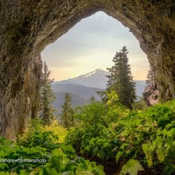
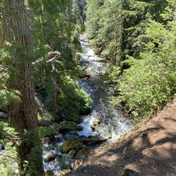
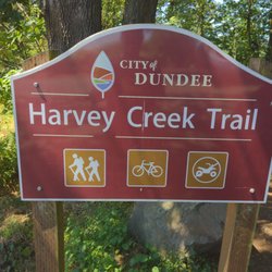
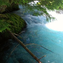
    Opal Creek Ancient Forest Center Photos

    You might also consider

    Recommended Reviews - Opal Creek Ancient Forest Center

    Your trust is our priority, so businesses can't pay to alter or remove their reviews. Learn more about reviews.
    Yelp app icon
    Browse more easily on the app
    Review Feed Illustration

    Reviews With Photos

    Michelle P.

    Great place to hike and swim! Make sure you pack accordingly if you're going on one of the longer hikes but honestly it's a good place to come early so you can savor every moment.

    See all

    6 years ago

    Helpful 4
    Thanks 0
    Love this 2
    Oh no 0

    9 years ago

    Helpful 6
    Thanks 0
    Love this 2
    Oh no 0

    8 years ago

    Helpful 4
    Thanks 0
    Love this 0
    Oh no 0

    8 years ago

    Helpful 1
    Thanks 0
    Love this 1
    Oh no 0

    13 years ago

    Helpful 11
    Thanks 0
    Love this 5
    Oh no 0

    10 years ago

    Helpful 6
    Thanks 0
    Love this 1
    Oh no 1
    Photo of Michael P.
    30
    119
    32

    7 years ago

    Helpful 3
    Thanks 0
    Love this 0
    Oh no 0
    Photo of Quisha F.
    252
    198
    406

    10 years ago

    Helpful 5
    Thanks 0
    Love this 3
    Oh no 0

    9 years ago

    Helpful 0
    Thanks 0
    Love this 0
    Oh no 0

    9 years ago

    Helpful 2
    Thanks 0
    Love this 3
    Oh no 0

    Ask the Community - Opal Creek Ancient Forest Center

    How long is the hike in time?

    The full hike to Jawbone Flats and Opal Pool is 6.6 miles, but there are shorter options. The hike begins at the Opal Creek Gate Trailhead, and actually follows a road -- though it's no ordinary road. Gigantic trees 700 years old rise overhead and… Read more

    Is this dog friendly?

    Yes it is

    View All 4 Questions

    Review Highlights - Opal Creek Ancient Forest Center

    The trail follows the creek and is actually the service road for Jawbone Flats.

    Mentioned in 3 reviews

    Read more highlights

    Verify this business for free

    Get access to customer & competitor insights.

    Verify this business

    Tamolitch Falls - The Blue Pool - Bathrooms

    Tamolitch Falls - The Blue Pool

    4.9(27 reviews)
    38.0 mi

    Last stop on our trip to Oregon before heading back to San Diego. It was May 1st and we arrived…read morearound 9am so it was not that busy. Drive: Basic mountain roads. Most roads feel brand new with well marked lines and signs. Parking/trailhead: Signs clearly marked parking area for Blue Pool. Long road leading up to trailhead is unpaved and parking is only allowed on one side. Luckily we were early so got a spot not too far down. Two restrooms, pretty stinky but what can you expect? Trail: Pretty easy hike. Mostly even paths I think overall theres about 300 feet gain on it. Some parts were very muddy, a big portion is rocky with lots of lava rock. Some parts have tree roots sticking up. CAUTION: Parts of trail have a really high cliff that drops off into the river with no markings so be careful especially with dogs or kids. Pool: Of course amazing views once you get to the pool. The side you arrive on is on a cliff with the view of the pool below. You can hike down to the pool by hiking around the edge but some parts are really close to the edge. Descending and ascending is difficult and is not for the weak. Over all we had an amazing time. The hike was a little longer than I thought but nothing too crazy even for a novice hiker. I would suggest bringing water and snacks, we didn't and regretted it. If you get down to the water at least dip your feet in. We did and it felt amazing and we actually felt reguvenated for our hike back.

    Great trail leading up to the pool. Not a difficult hike at all. Wouldn't suggest doing it when…read moreit's dark though as there are small rocks and rocky areas that can seem to pop out of nowhere and destroy your ankles. The pool is Absolutely beautiful and this is my favorite color. Once you see the one sign that says no bikes allowed, turn towards the water and look over the cliff.

    Photos
    Tamolitch Falls - The Blue Pool
    Tamolitch Falls - The Blue Pool - Caught a rainbow

    Caught a rainbow

    Tamolitch Falls - The Blue Pool

    See all

    Abiqua Falls Trailhead - The ropes section of the hike wasn't as daunting as initially feared.

    Abiqua Falls Trailhead

    4.4(10 reviews)
    18.3 mi

    Abiqua Falls! I just visited this beautiful 92-foot waterfall sort of in the middle of nowhere in…read moreOregon but located about 50 miles south of Portland. I have a lot to relay about the experience. This review could take the maximum 5000 words, lol, but I'll try my best to keep things as concise as possible... There are many questions about what to expect from Abiqua Falls. Even myself, I had concerns and doubts. But...I survived and it's an easy adventure to a very secluded waterfall. I'll try and answer the following questions... - Can you drive to the trailhead? From my POV, it's a VERY ROUGH ROAD down to the bottom. There's one specific section (and you'll recognize it immediately) where the road is practically cracked in half with divots and potholes. I actually witnessed a Ford Explorer trying to drive over it on the way back up and it was a big struggle for them! They eventually got past it, but I thought they were stuck. You absolutely need a high clearance 4x4 vehicle to make it down to the base to access the trailhead to Abiqua Falls. For me...I have a Suburu and I parked 2 miles away at the Abiqua Falls "Parking Lot" (according to Google) and then walked 2 miles down to the bottom and 2 miles back up. There was no way I was risking a flat tire, especially with not knowing how to change a tire and there barely being cell phone reception in the area. Btw...just to arrive at the Abiqua Falls parking lot, you must first drive 1.5 miles on a dirt road. For me, dirt and gravel roads are like nails on a chalkboard. I cringe driving over them. - Where is the trailhead located? This is a good question because there's no specific sign for Abiqua Falls, but it's easy to discover. Here's how...the road down to the bottom only goes so far. Eventually, you'll confront a white fence where you can leave your car (if you drove). But...there's a clear opening to the forest on the left-hand side of the road as you're going down. People say it's hard to find, but truly...you can't miss it. If you're any sort of outdoors enthusiast, it's simple. The hike is 7/10ths of a mile out and back. That's it! Again...there's barely any hiking involved, especially if you drive down to the base. - What is the ropes section like on the trail? I must be transparent. I read other people's AllTrails and Google reviews, and this can be deceiving. Let me explain... There were many reviews saying how the ropes section is intense and you're practically repelling down the cliff side. WRONG! WRONG! WRONG! It's an easy pathway. The ropes are no big deal. I have a serious fear of heights, and I casually made my down to the creek. Using the ropes was necessary for the most part, but it wasn't scary. It didn't strain my hands. IT IS NOT STRESSFUL! I'd rate the trail as easy - moderate. Do not fear the incline/decline slope. There's nothing of that sort. It is 100% safe to get up and down the trail. Once down at the bottom of the creek, hang on the left hand side. You'll notice the trail continuing around the bend that leads straight to Abiqua Falls. It's easy. I had no problems at any point in time. I've been on much, much rougher trails during my explorations. I visited on a random Thursday morning at the end of August and pretty much had the falls to myself. There were a few people that came along towards the middle of the day. I believe if you're coming to Abiqua Falls, you must bring a bathing suit and towel. I think it's a right of passage. The waterfall is scenic and the setting is charming, but other than admiring the views and maybe having a picnic, you must take the plunge in the pool of water that Abiqua Falls splashes down into. - Was the water cold? Absolutely! Lol, I was dreading the cold water but made the premeditated decision that I was swimming to have a fun memory. It wasn't even hot outside as well, but I forced myself in and I'm glad I just did it. Obviously, your body adjusts to the cold and it's not too extreme. Overall, the ambiance at Abiqua Falls was liberating. The canyon walls sort of engulf you from high above. You're standing at this dramatic waterfall and when the sun reaches above the tree line, you can notice some slight coloring in the waters which can make for a magical moment. In all, maybe you need a few hours to hang out at the falls before returning to the ropes section and heading back up to the trailhead and road. Again, the hike back up to the top is barely strenuous. It's a slight workout. Most folks can handle it. Lastly, if you're someone who left their car all the way at the top of the road (like I did), it is possible that you may get offered a lift from those hikers who took a chance driving their cars down to the base. If so, hop in, lol. It'll save time not having to trek back uphill. In the end, I enjoyed getting to witness Abiqua Falls. The journey to arrive here was not as daunting as I initially anticipated. And again, from my POV, be kind to your car tires. Don't risk the drive.

    Extremely steep. Rope system down to the bottom. I ended up fracturing my spine in 2 places due to…read morea fall. But if you're able to make it then go. Physical fitness is a MUST But a stunning falls to see

    Photos
    Abiqua Falls Trailhead - The trailhead to Abiqua Falls. It's located on the left hand side of the road.

    The trailhead to Abiqua Falls. It's located on the left hand side of the road.

    Abiqua Falls Trailhead - This is Abiqua Falls, a fantastic under the radar  Oregon waterfall.

    This is Abiqua Falls, a fantastic under the radar Oregon waterfall.

    Abiqua Falls Trailhead - Had Abiqua Falls Trail pathway saved on my phone, just in case I got lost.

    See all

    Had Abiqua Falls Trail pathway saved on my phone, just in case I got lost.

    Silver Falls State Park - Information desk

    Silver Falls State Park

    4.7(361 reviews)
    21.9 mi

    If you're gonna do the Trail of 10 Falls (or 8 as it was recently due to northside trail closure),…read moreI recommend a counter-clockwise route starting at South Falls to avoid crowds and work your way up the magnificence scale. Also helps to get there early as you can. Trails were wet from recent showers but well-maintained and not slick. If it's really been raining and the falls are pumping, be prepared for standing water behind a couple of the falls. (Luckily someone had put out small stones to balance on, but from the looks of their wet shoes many people were unlucky in their attempts to cross.) Walking sticks can be helpful in the steeper grades. It now costs $10 to park unless you've got an annual pass

    Daily parking permits are $10 per day, per vehicle for Oregon residents, and $12 per day otherwise…read more There are machines that sell the permits at the parking lots, so it's a pretty straightforward process. I went when there was a lot of rainfall, and so there was actually an emergency trail closure that spanned the majority of the park. Fortunately, the Canyon trail between the South Falls and the Lower South Falls was still open, and so I hiked that trail. It was absolutely amazing!! The falls were roaring and the creek was almost overflowing. The hike began with dark clouds and rain. As the trail led down and behind South Falls, the spray from the falls was heavier than the rain, soaking you from head to toe. The path then hugs the creek, which threatened to take over the trail at some points. There's a flight of stairs right before the Lower Falls, and at this point you can hear the thundering crash of the falls. As you go behind the falls, a shroud of darkness envelops you and you realize that suddenly you're fording through ankle deep water. With the loss of sight comes with the deafening noise of the tumbling water, and the spray attacks you every which way. Stumbling through, you emerge and find that the rain has stopped. As you crest up the path, the sun breaks, filtering through the trees with only the silence of the forest, punctuated with the occasional plop-plops of the trees shedding the water drops of the earlier rain. The silence is almost deafening. Good thing that the trail takes you right to the Lodge, which has a roaring fire inside to dry yourself with! There are also cool nature exhibits inside, as well as a small cafe to get drinks to warm yourself from the inside too. I would come here again, rain or shine!

    Photos
    Silver Falls State Park - South Falls, Silver Falls State Park, Oregon.

    South Falls, Silver Falls State Park, Oregon.

    Silver Falls State Park - Bridges

    Bridges

    Silver Falls State Park - Love a stone paved bridge

    See all

    Love a stone paved bridge

    Starker Forests - Starker Forest Tour

    Starker Forests

    5.0(1 review)
    59.2 mi

    We came upon Starker Forestry Tour trail online when checking along the 20 for short trails we…read moremight want to check out as passing through. It's super easy to find from the 20, just a few minutes down a paved and gravel road with good signage. There's a small parking area at an intersection of roads where the tour begins. As a tree hugger I generally cringe, plug my ears, or turn away from anything involving the removal of even one tall beauty. But I will admit, after taking the informative trail I respected the education and information provided by the tour. The trail starts at a large covered pavilion with long benches and utilizes signposts along the short loop to help both kids and adults learn about the industry, as well as the natural inner workings of the forest. Special focus is given to beauty #15 and it's individual purpose, as well as how the environment around it has changed through the years. The path is well-maintained, fairly flat and easy, with an even gravel surface. Seemingly in the middle of nowhere, the Starker Forestry Tour has a beautiful setting and offers a simplistic way to learn a bit more about the gorgeous Oregon forests.

    From the owner: At Starker Forests, we grow and harvest trees while working to protect the environment. We allow…read morepublic access for hiking, hunting and mountain biking. All visitors to Starker Forests must obtain a free recreation permit.

    Photos
    Starker Forests - Starker Forest Tour

    Starker Forest Tour

    Starker Forests
    Starker Forests - Starker Forest Tour

    See all

    Starker Forest Tour

    Opal Creek Ancient Forest Center - hiking - Updated May 2026

    Loading...
    Loading...
    Loading...