Starker Forests Photos


More like Starker Forests
Recommended Reviews - Starker Forests
Start your review...

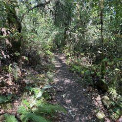
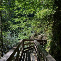
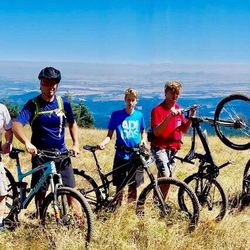
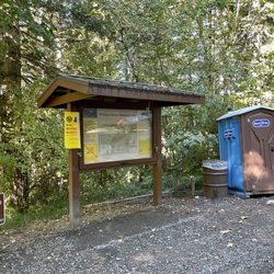
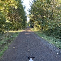
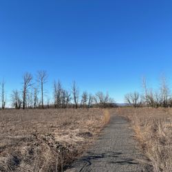
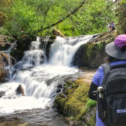
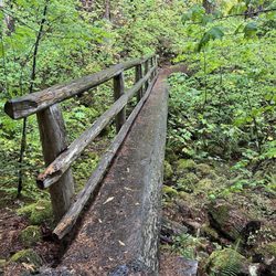
We came upon Starker Forestry Tour trail online when checking along the 20 for short trails we might want to check out as passing through. It's super easy to find from the 20, just a few minutes down a paved and gravel road with good signage. There's a small parking area at an intersection of roads where the tour begins. As a tree hugger I generally cringe, plug my ears, or turn away from anything involving the removal of even one tall beauty. But I will admit, after taking the informative trail I respected the education and information provided by the tour. The trail starts at a large covered pavilion with long benches and utilizes signposts along the short loop to help both kids and adults learn about the industry, as well as the natural inner workings of the forest. Special focus is given to beauty #15 and it's individual purpose, as well as how the environment around it has changed through the years. The path is well-maintained, fairly flat and easy, with an even gravel surface. Seemingly in the middle of nowhere, the Starker Forestry Tour has a beautiful setting and offers a simplistic way to learn a bit more about the gorgeous Oregon forests. read more


More info about Starker Forests
7240 SW Philomath Blvd
Corvallis, OR 97333
Directions
(541) 929-2477
Call Now
Visit Website
http://www.starkerforests.com
Hours
Outdoor Amenities
From the Business
Ask the Community - Starker Forests


Starker Forests - hiking - Updated June 2026
Best of Corvallis
People found Starker Forests by searching for…
Things to Do in Corvallis, Oregon
Hiking Trails With Waterfalls in Corvallis, Oregon
Horseback Riding on Beach in Corvallis, Oregon
Swimming Lakes in Corvallis, Oregon
Fun Things to Do at Night in Corvallis, Oregon
Playgrounds in Corvallis, Oregon
Mountain Bike Trails in Corvallis, Oregon
Picnic Areas in Corvallis, Oregon
Horse Summer Camp in Corvallis, Oregon
Easy Hikes in Corvallis, Oregon
Walking Trails in Corvallis, Oregon
Fun Things to Do for a Birthday in Corvallis, Oregon
Beautiful Views in Corvallis, Oregon
Horse Boarding in Corvallis, Oregon
Off Road Trails in Corvallis, Oregon
Tent Camping in Corvallis, Oregon
Secluded Spots in Corvallis, Oregon
Horse Stables in Corvallis, Oregon
Running Trails in Corvallis, Oregon
Hiking Club in Corvallis, Oregon
Trending Searches in Corvallis, OR
4th Of July Fireworks near Starker Forests
Boat Rental near Starker Forests
Cliff Jumping near Starker Forests
Day Trips near Starker Forests
Dog Friendly Trails near Starker Forests
Fireworks near Starker Forests
Fishing Spots near Starker Forests
Kayak Rental near Starker Forests
Lakes & Ponds near Starker Forests
Mountain Biking near Starker Forests
Outdoor Activities near Starker Forests
Picnic Areas near Starker Forests
Public Pools near Starker Forests
Public Shower near Starker Forests
River Swimming near Starker Forests
Rock Quarry near Starker Forests
Scenic Night View near Starker Forests
Scenic Overlook near Starker Forests
Secluded Spots near Starker Forests
Soccer Store near Starker Forests
Splash Pad near Starker Forests
Star Gazing near Starker Forests
Strawberry Picking near Starker Forests
Sunrise View near Starker Forests
Swimming Holes near Starker Forests
Swimming Lakes near Starker Forests
Watch Sunset near Starker Forests
Water Parks near Starker Forests
Browse Articles
Browse Nearby
Browse Brands
Related Searches in Corvallis, OR
Affordable Bike Repair Services in Corvallis, Oregon
Affordable Bike Tune Up Services in Corvallis, Oregon
Affordable Horse Boarding Services in Corvallis, Oregon
Affordable Jet Ski Rental Options in Corvallis, Oregon
Affordable Kayak Rental Services in Corvallis, Oregon
Affordable Tandem Bike Rental in Corvallis, Oregon
Best Electric Bike Rental Services in Corvallis, Oregon
Best Fishing Locations and Guides in Corvallis, Oregon
Best Fun Things to Do in Corvallis, Oregon
Best Gymnastics for Kids Activities in Corvallis, Oregon
Best Places for Horseback Riding in Corvallis, Oregon
Challenging Escape Room Adventures in Corvallis, Oregon
Check Out Off Road Trails in Corvallis, Oregon
Discover Fun Activities to Do in Corvallis, Oregon
Discover Horseback Riding Tours in Corvallis, Oregon
Discover Popular Bike Tours in Corvallis, Oregon
Discover Romantic Activities to Enjoy in Corvallis, Oregon
Discover Scenic Mountain Bike Trails Near Corvallis, Oregon
Discover Scenic Waterfall Spots in Corvallis, Oregon
Discover a Hiking Trail in Corvallis, Oregon
Discover the Best Night Hike Trails in Corvallis, Oregon
Dog-Friendly Hikes With Dogs in Corvallis, Oregon
Enjoy Camping Adventures Around Corvallis, Oregon
Enjoy Exciting Mountain Biking Adventures in Corvallis, Oregon
Enjoy Hiking Adventures in Corvallis, Oregon
Enjoy Kayaking Adventures in Corvallis, Oregon
Enjoy Scenic Night View Experiences in Corvallis, Oregon
Enjoy Tent Camping Spots Around Corvallis, Oregon
Enjoy a Beautiful Waterfall Hike in Corvallis, Oregon
Enjoy a Relaxing Bed & Breakfast Experience in Corvallis, Oregon
Enjoy the Best Mini Golf Courses in Corvallis, Oregon
Enjoy the Best Tubing Experiences in Corvallis, Oregon
Enjoy the Best Walking Trails in Corvallis, Oregon
Exciting Cliff Jumping Spots in Corvallis, Oregon
Experience Exciting Horse Racing in Corvallis, Oregon
Explore BMX Bike Shops Near Corvallis, Oregon
Explore Beautiful Parks and Green Spaces in Corvallis, Oregon
Explore Bike Rentals Throughout Corvallis, Oregon
Explore Easy Hikes Perfect for All in Corvallis, Oregon
Explore Electric Bikes Available in Corvallis, Oregon
Explore Fun Activities to Do in Corvallis, Oregon
Explore Horse Stables and Boarding in Corvallis, Oregon
Explore Nature Spots Around Corvallis, Oregon
Explore Popular Campgrounds Near Corvallis, Oregon
Explore Popular Scenic Overlook Points in Corvallis, Oregon
Explore Popular View Points Around Corvallis, Oregon
Explore Pumpkin Patches Around Corvallis, Oregon
Explore Scenic Lakes to Visit in Corvallis, Oregon