Tamolitch Falls - The Blue Pool Photos


More like Tamolitch Falls - The Blue Pool
Recommended Reviews - Tamolitch Falls - The Blue Pool
Start your review...

Reviews With Photos

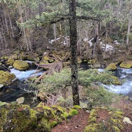
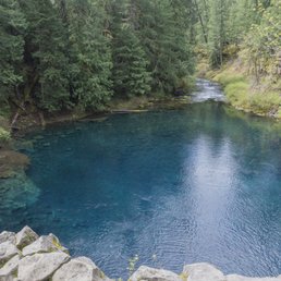
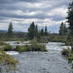
Fabulous and fun trail! The falls part of Tamolitch only occurs occasionally, but the stunning blue pool is there for your enjoyment year round. We knew enough to arrive in the morning (8:30 on a Sunday) to avoid the crowds. Even in March the parking area was full by the time we returned at about 11:30. We had the trail and the pool to ourselves, but encountered hikers regularly most of the way back. Lots of dogs as well, leashed and not. The trail itself is very fun, but definitely not for everyone. It's pretty short at about 4 miles total out and back. The path is varied right now as far as conditions: dry, muddy, standing water, snow. The footing is varied as well, with loads of roots and rocks...you have to watch the ground and traverse carefully most of the way. Soaking up that gorgeous, crystal clear aqua pool at the end should make the trek worth it for most anyone. It's definitely something you need to see for yourself, no picture can do it justice. During our visit we had a great mirror, but we could also easily see the bottom. If you're a nature and forest lover a visit to the Blue Pool is a must. Stunning forest, trekking through the lava rock, a spectacular pool seeming to appear from nowhere and feeding a beautiful river...equal goooood times!

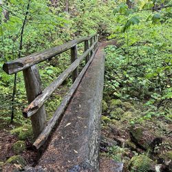
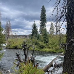
100% worth it. I've got some tech notes further in this review, but for the executive summary let me just say, you will regret it if you have the opportunity to visit this pool and don't take advantage of it. Life is short and hard, take a day to immerse yourself in this beautiful place. I drove south from Portland on I-5, then east on OR-20 from Salem. The roads are maintained and well marked. Once you're on OR-126 you'll go about 9 more miles and see a green Tamolitch Blue Pool sign on the right. Keep going. That's not the entrance you want. Another couple minutes down the hill you make a right at Reservoir Bridge. Head in, bear right, gravel, trailhead, basta! Don't forget to hang your forest service pass from the mirror before you set out. There are bathrooms, and signs with trail info. The bike trail heads straight up (looks hard as get out), and the pool trail is to the right. All Trails has it as moderate but I found it pretty easy. Very little gain and only a couple of scrambles. A lovely walk along a clear path, river on one side, crazy fern covered deep forest on the other. As with most places there is a leash requirement for dogs, and nobody has their dog on a leash. Rules: leash you dog. Oregonians: chillax bruh, he's good. It's only 2.25 miles to the pool, take your time, but also take some water, a snack, an additional layer, and maybe a hat. I saw folks out there in tennis shoes. That's just not respecting what a whack nature can give you if you don't prepare properly. The pool is even better in person. It's a shade of blue you usually only find in super filtered IG photos. Breathtaking. It's crystal clear; you can count the rocks in the deepest parts. I sat there quietly and watched birds come and go, listened to the river, felt the wind. I stayed still long after the cold from the rock started to seep into my bones, unwilling to walk away from such transcendent beauty. When I finally pulled myself away and started back, I honestly felt fresher, lighter, unburdened. What a gift nature is. I hope you enjoy this hike!

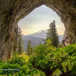
Beautiful trail slightly tucked away from the main road that is about 4 miles in and out and leads to a beautiful blue reflective pool at the end of the trail. The trail is so peaceful and things look beautiful from beginning to end. Certainly try to come during hour to see the beauty of the sun rays through the trees. Free parking near the trailhead and there's a separate path for bikers
Really pretty trail! I came here right after it rained, so the trail was muddy, wet, and a bit humid - but still beautiful. I really enjoyed myself, saw a lot of people though which wasn't great. Parking was also way down the street although because I came a bit later, I managed to snag a spot pretty close to the trailhead. Trail is covered by trees and it goes along the river for a bit. Super pretty blue pool at the end!


This place is absolutely breathtaking ! Not going to lie, I'm not sure if it was because I was on a time crunch or because i stopped EVERY two minutes to take a picture because it was so pretty !!!, but the hike did seem a little longer than I thought it would be on the way to the blue pool. But it was so so so worth it. Just a heads up, there is a lot of jumping and skipping around some main paths due to muddy trails. Definitely possible by anyone but it might be a barrier to those with knee problems. Did I already say how mesmerizing this gem was ? I will definitely be back when in Oregon :)

I'm honestly surprised that this little trail isn't more popular! My boyfriend and I stumbled across this hidden gem on Instagram and decided to stop by on our way to Portland. Let me just say that the photos do not do this beautiful place justice! If you're in the area, do yourself a favor and stop by. Not knowing the area we had a bit of trouble finding the exact location so here's a few tips based off my own personal experience. Once you drive in to the parking area, you'll see signs to parallel park on your right hand side. DO NOT park on your left. The parking doesn't look like a parking area, to us it just looked like a road. But just look for the small signs and you should easily find where to park. DO NOT drive up the little hill past the restrooms, if you pass the restrooms you drove too far. This leads me to my next tip. Yes, there are restrooms, no they aren't clean. Use at your own risk! Once you park, walk up toward the hill and the trail is on your right hand side just a bit past the map. We were the first ones to arrive on a Saturday morning. On our way back it was about 8am and there were plenty of people starting off their hike, so plan accordingly. Some locals told us that this place gets packed! The hike to the Blue Pool is about 2.08 miles one way according to my Apple Watch. I would call it a relatively easy hike but recommend hiking boots due to the lava rock. We had hiking shoes and our feet were still sore afterwards. COVID 19 PANDEMIC ADVICE: Hardly anyone we saw was wearing a mask. I recommend you arrive early to avoid large crowd interactions.

I took a trip to Oregon recently and oh my lord, I am having some serious withdrawals! Walking in to work Monday morning was rough lol. Anyway, I wanted to spend quality time in the great outdoors AND OREGON DELIVERED! Here are a few things to know about the trail. -Part of the McKenzie River National Recreational Trail, Tamolitch is best known for breathtaking views of a clear and gorgeously blue pool. So peaceful and serene. -When driving, in, do not park on the left side of the road closer to the trail. Several cars received tickets when during my trip. If you have trouble finding parking close by, drive back to the overflow lot. -Sometimes, there is a man and a woman selling drinks/snacks in the parking lot. They are really nice and chill. No fixed prices so pay what you want. -I HIGHLY recommend having a picnic once you get to the blue pool. -There are no rubbish bins at the falls so please take your trash back with you. Don't be THAT person... -During my hike, I was passed a few times by people who were in a rush to see the falls/pool. I implore you to take your time on the trail and appreciate the views of the forrest. -Unfortunately, this is apparently a rather popular destination so do try to arrive early to avoid the crowd. -Tamolitch is also not the best choice if you are in search of a challenge. I started at the reservoir and the hike was only about 2 miles to the falls. -Still, wear closed-toe shoes with grip and mind your footing. There are a few challenging spots along the trail as well as loose lava rock. A few of my friends fell and I nearly fell a number of times. -This trail is heavily shaded. I loved that as the trails in my area are mostly open and the sun just beats down during the summer. -Don't forget to pack bug spray. -This is not a swimming hole as the water is cold (37 degrees on average)! Muscles start to cramp up and it becomes difficult to move. Take a short dip if you like but don't expect to play in there as if it were your local swimming pool. -On that note, do not go cliff diving! One guy attempted it while we were there and we watched him struggle to swim back to shore. One bada** woman swam out to save him. -Pack a camera. Take plenty of photos. Collect memories instead of things. Enjoy! :]


I still cannot get over how beautifully blue this pool is! We accessed it by parking at the Koosah Falls trailhead, then hiking the Waterfalls Trail down to the bridge at Carmen Reservoir, then picking up the McKenzie River Trail from there (there is a sign to the right of the restroom at the end of that road marking the spot where the trail begins). It was definitely a longer hike, but I am so glad we did it. I am sure it can probably be accessed more closely from the road, but we wanted to see the waterfalls also, so we figured we'd just hike the trail all the way down. Such a beautiful area, and there's nothing quite like being in the presence of trees all day :) Little tip: There's a bunch of chipmunks that hang out above the Blue Pool, and they REALLY like nuts! So fun to watch them scurrying around with their cheeks shoved full of snacks from their new friends :)

Oh man, I just realized you can Yelp anything, including the outdoors, sweet! Blue Pool is really something special. Surrounded by-god only knows how old-trees, towering high above, shining their wisdom down upon you.... I hiked it alone on a rainy Sunday and had a lovely solitary experience the majority of the time and only saw a few couples and some single runners along the way. From far away, blue pool is really nothing to get excited over, but just wait...up close it is majestic!

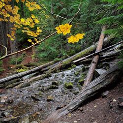
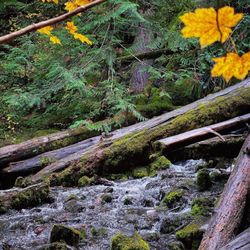
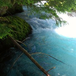
Tamolitch Falls, aka "The Blue Pool", is a hidden gem located within the McKenzie River National Recreation Trail, approximately 3 hours south of Portland. To get to the Blue Pool, we started at the Sahalie Falls and Koosah Falls trail. Just google the Sahalie Falls and Google Map should take you to the trailhead. The trail to the Blue Pool is roughly 8 miles roundtrip. Sahalie Falls can be seen right by the parking lot. As you follow the steps/trail further down the river, you'll find Koosah Falls in about 0.4 miles. Both of the waterfalls are not tall but are extremely powerful. It was super neat to see the gallons of water flowing right down the waterfall and into the McKenzie River. It was like water coming out of a fire hydrant. As you continue along the blue-colored McKenzie River, you'll stumble upon the Carmen Reservoir. Just FYI, there is a restroom here. From the Carmen Reservoir, turn right and continue on the McKenzie River Trail (you'll see a small sign). You won't see the river here as it has gone underground. It is about a 3 mile through the Douglas fir forest until you get to the Blue Pool. Once you've made it, you'll realize it was all worth it. Tamolitch Falls used to be a waterfall until the McKenzie River changed its course and went underground, leaving just a pool of standing water, hence the name "Blue Pool". The water is so neon blue and clear that it looks more shallow than it really is. On a hot summer day, people like to jump into the pool. You can find a trail to get down at the top of the "waterfall". Just be careful as I heard the water can be quite cold. My friend and I started the trail around 3pm and didn't get back until 8pm. I swear I thought we were going to have to hike in the dark since the sun was setting but we eventually made it out. Thank goodness! It was also drizzling when we hiked this trail but despite the rain, I still enjoyed myself. The scenery was beautiful and there's always something to look at along the trail.

20 days ago
Last stop on our trip to Oregon before heading back to San Diego. It was May 1st and we arrived around 9am so it was not that busy. Drive: Basic mountain roads. Most roads feel brand new with well marked lines and signs. Parking/trailhead: Signs clearly marked parking area for Blue Pool. Long road leading up to trailhead is unpaved and parking is only allowed on one side. Luckily we were early so got a spot not too far down. Two restrooms, pretty stinky but what can you expect? Trail: Pretty easy hike. Mostly even paths I think overall theres about 300 feet gain on it. Some parts were very muddy, a big portion is rocky with lots of lava rock. Some parts have tree roots sticking up. CAUTION: Parts of trail have a really high cliff that drops off into the river with no markings so be careful especially with dogs or kids. Pool: Of course amazing views once you get to the pool. The side you arrive on is on a cliff with the view of the pool below. You can hike down to the pool by hiking around the edge but some parts are really close to the edge. Descending and ascending is difficult and is not for the weak. Over all we had an amazing time. The hike was a little longer than I thought but nothing too crazy even for a novice hiker. I would suggest bringing water and snacks, we didn't and regretted it. If you get down to the water at least dip your feet in. We did and it felt amazing and we actually felt reguvenated for our hike back. read more


Great trail leading up to the pool. Not a difficult hike at all. Wouldn't suggest doing it when it's dark though as there are small rocks and rocky areas that can seem to pop out of nowhere and destroy your ankles. The pool is Absolutely beautiful and this is my favorite color. Once you see the one sign that says no bikes allowed, turn towards the water and look over the cliff. read more

My boyfriend and I hiked to The Blue Pool while camping nearby, and it was such a memorable experience! A local recommended it to us, and I'm so glad they did. The hike itself is about 2 hours and starts out moderate but gets more challenging as you get closer to the pool. Definitely wear good shoes and bring water. I'd recommend going earlier in the day to avoid the afternoon crowds--it gets busy quickly. One tip: maps can take you to the wrong entrance. Thankfully, there's a sign posted with directions on where to park, so keep an eye out for that. It's also dog-friendly, which was a huge plus for us. Along the trail, there are several beautiful photo spots worth stopping for. When you finally reach The Blue Pool, you'll need to climb down to access it. The water stays around 38°F year-round, which makes it a popular "polar plunge" spot for brave swimmers. Some people even cliff jump, but please be careful! Overall, this is an absolute must-see if you're in the area. Stunning views, a fun challenge, and an unforgettable spot to experience nature. read more


Insanely fabulous view! This was well worth the 2 1/2 mile hike. Bathrooms (portable) at entrance. Rocky terrain path - hiking shoes recommended and possible trekking poles. Shaded areas to keep you cool. Beautiful scenic views along the path. read more


Fabulous and fun trail! The falls part of Tamolitch only occurs occasionally, but the stunning blue pool is there for your enjoyment year round. We knew enough to arrive in the morning (8:30 on a Sunday) to avoid the crowds. Even in March the parking area was full by the time we returned at about 11:30. We had the trail and the pool to ourselves, but encountered hikers regularly most of the way back. Lots of dogs as well, leashed and not. The trail itself is very fun, but definitely not for everyone. It's pretty short at about 4 miles total out and back. The path is varied right now as far as conditions: dry, muddy, standing water, snow. The footing is varied as well, with loads of roots and rocks...you have to watch the ground and traverse carefully most of the way. Soaking up that gorgeous, crystal clear aqua pool at the end should make the trek worth it for most anyone. It's definitely something you need to see for yourself, no picture can do it justice. During our visit we had a great mirror, but we could also easily see the bottom. If you're a nature and forest lover a visit to the Blue Pool is a must. Stunning forest, trekking through the lava rock, a spectacular pool seeming to appear from nowhere and feeding a beautiful river...equal goooood times! read more


100% worth it. I've got some tech notes further in this review, but for the executive summary let me just say, you will regret it if you have the opportunity to visit this pool and don't take advantage of it. Life is short and hard, take a day to immerse yourself in this beautiful place. I drove south from Portland on I-5, then east on OR-20 from Salem. The roads are maintained and well marked. Once you're on OR-126 you'll go about 9 more miles and see a green Tamolitch Blue Pool sign on the right. Keep going. That's not the entrance you want. Another couple minutes down the hill you make a right at Reservoir Bridge. Head in, bear right, gravel, trailhead, basta! Don't forget to hang your forest service pass from the mirror before you set out. There are bathrooms, and signs with trail info. The bike trail heads straight up (looks hard as get out), and the pool trail is to the right. All Trails has it as moderate but I found it pretty easy. Very little gain and only a couple of scrambles. A lovely walk along a clear path, river on one side, crazy fern covered deep forest on the other. As with most places there is a leash requirement for dogs, and nobody has their dog on a leash. Rules: leash you dog. Oregonians: chillax bruh, he's good. It's only 2.25 miles to the pool, take your time, but also take some water, a snack, an additional layer, and maybe a hat. I saw folks out there in tennis shoes. That's just not respecting what a whack nature can give you if you don't prepare properly. The pool is even better in person. It's a shade of blue you usually only find in super filtered IG photos. Breathtaking. It's crystal clear; you can count the rocks in the deepest parts. I sat there quietly and watched birds come and go, listened to the river, felt the wind. I stayed still long after the cold from the rock started to seep into my bones, unwilling to walk away from such transcendent beauty. When I finally pulled myself away and started back, I honestly felt fresher, lighter, unburdened. What a gift nature is. I hope you enjoy this hike! read more


Beautiful trail slightly tucked away from the main road that is about 4 miles in and out and leads to a beautiful blue reflective pool at the end of the trail. The trail is so peaceful and things look beautiful from beginning to end. Certainly try to come during hour to see the beauty of the sun rays through the trees. Free parking near the trailhead and there's a separate path for bikers read more

Really pretty trail! I came here right after it rained, so the trail was muddy, wet, and a bit humid - but still beautiful. I really enjoyed myself, saw a lot of people though which wasn't great. Parking was also way down the street although because I came a bit later, I managed to snag a spot pretty close to the trailhead. Trail is covered by trees and it goes along the river for a bit. Super pretty blue pool at the end! read more


This place is absolutely breathtaking ! Not going to lie, I'm not sure if it was because I was on a time crunch or because i stopped EVERY two minutes to take a picture because it was so pretty !!!, but the hike did seem a little longer than I thought it would be on the way to the blue pool. But it was so so so worth it. Just a heads up, there is a lot of jumping and skipping around some main paths due to muddy trails. Definitely possible by anyone but it might be a barrier to those with knee problems. Did I already say how mesmerizing this gem was ? I will definitely be back when in Oregon :) read more


. - Hiking Near Me")

 to the blue pool. - Hiking Near Me")
I'm honestly surprised that this little trail isn't more popular! My boyfriend and I stumbled across this hidden gem on Instagram and decided to stop by on our way to Portland. Let me just say that the photos do not do this beautiful place justice! If you're in the area, do yourself a favor and stop by. Not knowing the area we had a bit of trouble finding the exact location so here's a few tips based off my own personal experience. Once you drive in to the parking area, you'll see signs to parallel park on your right hand side. DO NOT park on your left. The parking doesn't look like a parking area, to us it just looked like a road. But just look for the small signs and you should easily find where to park. DO NOT drive up the little hill past the restrooms, if you pass the restrooms you drove too far. This leads me to my next tip. Yes, there are restrooms, no they aren't clean. Use at your own risk! Once you park, walk up toward the hill and the trail is on your right hand side just a bit past the map. We were the first ones to arrive on a Saturday morning. On our way back it was about 8am and there were plenty of people starting off their hike, so plan accordingly. Some locals told us that this place gets packed! The hike to the Blue Pool is about 2.08 miles one way according to my Apple Watch. I would call it a relatively easy hike but recommend hiking boots due to the lava rock. We had hiking shoes and our feet were still sore afterwards. COVID 19 PANDEMIC ADVICE: Hardly anyone we saw was wearing a mask. I recommend you arrive early to avoid large crowd interactions. read more


I took a trip to Oregon recently and oh my lord, I am having some serious withdrawals! Walking in to work Monday morning was rough lol. Anyway, I wanted to spend quality time in the great outdoors AND OREGON DELIVERED! Here are a few things to know about the trail. -Part of the McKenzie River National Recreational Trail, Tamolitch is best known for breathtaking views of a clear and gorgeously blue pool. So peaceful and serene. -When driving, in, do not park on the left side of the road closer to the trail. Several cars received tickets when during my trip. If you have trouble finding parking close by, drive back to the overflow lot. -Sometimes, there is a man and a woman selling drinks/snacks in the parking lot. They are really nice and chill. No fixed prices so pay what you want. -I HIGHLY recommend having a picnic once you get to the blue pool. -There are no rubbish bins at the falls so please take your trash back with you. Don't be THAT person... -During my hike, I was passed a few times by people who were in a rush to see the falls/pool. I implore you to take your time on the trail and appreciate the views of the forrest. -Unfortunately, this is apparently a rather popular destination so do try to arrive early to avoid the crowd. -Tamolitch is also not the best choice if you are in search of a challenge. I started at the reservoir and the hike was only about 2 miles to the falls. -Still, wear closed-toe shoes with grip and mind your footing. There are a few challenging spots along the trail as well as loose lava rock. A few of my friends fell and I nearly fell a number of times. -This trail is heavily shaded. I loved that as the trails in my area are mostly open and the sun just beats down during the summer. -Don't forget to pack bug spray. -This is not a swimming hole as the water is cold (37 degrees on average)! Muscles start to cramp up and it becomes difficult to move. Take a short dip if you like but don't expect to play in there as if it were your local swimming pool. -On that note, do not go cliff diving! One guy attempted it while we were there and we watched him struggle to swim back to shore. One bada** woman swam out to save him. -Pack a camera. Take plenty of photos. Collect memories instead of things. Enjoy! :] read more


6 years ago
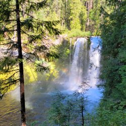
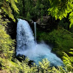
This place was magic. We did the short hike from the trailhead, probably 4 miles round trip to the pool. We didn't see a water fall, but it is mid August. Honestly the pool was magical enough without the waterfall. read more

7 years ago
I still cannot get over how beautifully blue this pool is! We accessed it by parking at the Koosah Falls trailhead, then hiking the Waterfalls Trail down to the bridge at Carmen Reservoir, then picking up the McKenzie River Trail from there (there is a sign to the right of the restroom at the end of that road marking the spot where the trail begins). It was definitely a longer hike, but I am so glad we did it. I am sure it can probably be accessed more closely from the road, but we wanted to see the waterfalls also, so we figured we'd just hike the trail all the way down. Such a beautiful area, and there's nothing quite like being in the presence of trees all day :) Little tip: There's a bunch of chipmunks that hang out above the Blue Pool, and they REALLY like nuts! So fun to watch them scurrying around with their cheeks shoved full of snacks from their new friends :) read more


Oh man, I just realized you can Yelp anything, including the outdoors, sweet! Blue Pool is really something special. Surrounded by-god only knows how old-trees, towering high above, shining their wisdom down upon you.... I hiked it alone on a rainy Sunday and had a lovely solitary experience the majority of the time and only saw a few couples and some single runners along the way. From far away, blue pool is really nothing to get excited over, but just wait...up close it is majestic! read more


Tamolitch Falls, aka "The Blue Pool", is a hidden gem located within the McKenzie River National Recreation Trail, approximately 3 hours south of Portland. To get to the Blue Pool, we started at the Sahalie Falls and Koosah Falls trail. Just google the Sahalie Falls and Google Map should take you to the trailhead. The trail to the Blue Pool is roughly 8 miles roundtrip. Sahalie Falls can be seen right by the parking lot. As you follow the steps/trail further down the river, you'll find Koosah Falls in about 0.4 miles. Both of the waterfalls are not tall but are extremely powerful. It was super neat to see the gallons of water flowing right down the waterfall and into the McKenzie River. It was like water coming out of a fire hydrant. As you continue along the blue-colored McKenzie River, you'll stumble upon the Carmen Reservoir. Just FYI, there is a restroom here. From the Carmen Reservoir, turn right and continue on the McKenzie River Trail (you'll see a small sign). You won't see the river here as it has gone underground. It is about a 3 mile through the Douglas fir forest until you get to the Blue Pool. Once you've made it, you'll realize it was all worth it. Tamolitch Falls used to be a waterfall until the McKenzie River changed its course and went underground, leaving just a pool of standing water, hence the name "Blue Pool". The water is so neon blue and clear that it looks more shallow than it really is. On a hot summer day, people like to jump into the pool. You can find a trail to get down at the top of the "waterfall". Just be careful as I heard the water can be quite cold. My friend and I started the trail around 3pm and didn't get back until 8pm. I swear I thought we were going to have to hike in the dark since the sun was setting but we eventually made it out. Thank goodness! It was also drizzling when we hiked this trail but despite the rain, I still enjoyed myself. The scenery was beautiful and there's always something to look at along the trail. read more


It's worth the hike. Get there early, if you go in a weekend or you might have to walk 1/2 mike just to get to the trailhead. Easy hike, no elevation increases. Watch out for mountain bikers. The water is very cold . I saw a few brave souls strip down to their skivvies and jump in, only to screech and hurry out. There is about a 60 foot climb down to the pool but it wasn't too challenging. read more


8 years ago
Popular hiking spot. The walk out to the Pool is not as nice as the shorter and less populated trail a few miles up the road between Sahalie and Koosah Falls. But the Pool itself is gorgeous. Can be a little buggy around the Pool... read more

9 years ago
I have run the majority of this trail...not all at once mind you! Over the years I have traveled to the McKenzie river area time and time again. I am brought back by the Blue Pool, the falls and the Belknap Hot Spring Lodge. Ever time I see new and amazing things, each season the falls and blue pool have something different to offer! My first time on this trail started while fly fishing just under the Trailbridge bridge. I decided it was time for a little training run and started down the Tamolitch Falls/Blue Pool trail. Ill let the views speak for themselves. Check out my fitness blog and learn where all of the McKenzie River gems are hidden! https://www.draekk.com/blog/2017/5/31/wet-wild-wednesday-tamolitch-falls-blue-pool read more

9 years ago
I made it out here last Saturday. I have been out here about 6 or 7 times by now and this is the first time I have ever witnessed the waterfall running. This might be the earliest that I have been out here, but I do believe the gnarly winter may play a role in this. If you have ever wanted to check out this pool, now is the time. Though it is important to stay on the trail and bring water shoes because the little creek on the north trail has flooded the trail. Watch out for snakes, I saw about 5 just in the three hours we were out there. read more


9 years ago
So BEAUTIFUL! I saw pictures and still was not prepared for the spectacular blue water! The hike was easy and the reward of the turquoise blue, super clear water is heavenly! The water is very cold but a must to jump in during the summer. Can't wait to return read more


9 years ago
I absolutely loved this hike! The Blue Pool is definitely one of the coolest things I've ever seen! I made a video of the hike if anyone is interested! https://youtu.be/RoKVto7HPM8 We went on a hot Saturday in May. Got there in the afternoon and it was still pretty busy. I recommend wearing good hiking/tennis shoes as it was pretty muddy. You should also bring lots of water. The Blue Pool was too cold for me to swim in, but I did dip my feet in the freezing water! I definitely recommend checking it out, and I would go again in a heartbeat! read more

9 years ago
Fairly long hike, but worth the trip... too cold to swim in, but the pool itself is amazing!!!! read more


8 years ago
9 years ago
More info about Tamolitch Falls - The Blue Pool
Blue River, OR 97759
Directions
(541) 844-5990
Call Now
Hours
Outdoor Amenities
Ask the Community - Tamolitch Falls - The Blue Pool
Review Highlights - Tamolitch Falls - The Blue Pool


Tamolitch Falls - The Blue Pool - hiking - Updated May 2026
Best of Blue River
People found Tamolitch Falls - The Blue Pool by searching for…
Swimming Holes in Blue River, Oregon
Hiking Trails With Waterfalls in Blue River, Oregon
Swimming Lakes in Blue River, Oregon
Hot Spring in Blue River, Oregon
Things to Do in Blue River, Oregon
Cliff Jumping in Blue River, Oregon
Secret Spots in Blue River, Oregon
Scenic Drive in Blue River, Oregon
Sunset View in Blue River, Oregon
River Swimming in Blue River, Oregon
Fishing Lake in Blue River, Oregon
Fishing Spots in Blue River, Oregon
Scenic Overlook in Blue River, Oregon
Waterfalls in Blue River, Oregon
Dog Swimming in Blue River, Oregon
Scenic Views in Blue River, Oregon
Off Leash Dog Hiking Trails in Blue River, Oregon
Photo Spots in Blue River, Oregon
View Points in Blue River, Oregon
Easy Hikes in Blue River, Oregon