Sahalie Falls Photos


More like Sahalie Falls
Recommended Reviews - Sahalie Falls
Start your review...

Reviews With Photos

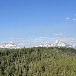
This is Sahalie Falls, and not just Sahalie Falls, but also walking along Waterfalls Trail is Koosah Falls. You get 2 for the price of 1 admission! That's a pretty good deal. And I'm not done, lol...4 miles north on Highway 126 is fantastic Tamolitch Falls or otherwise known as Oregon's Blue Pool! So if you're a fan of waterfalls, forests and the great outdoors, this area along the McKenzie River is full of fantastic natural wonders. Before diving into the details about Sahalie Falls, I'll just mention I spent 1 full day hiking to the Blue Pool in the morning and then venturing over here around 3:30pm for some waterfalls' sightseeing. It made for a glorious day surrounded by nature at its finest. For late afternoon at the end of July, I was barely able to grab a parking spot in the small lot, and I'm convinced that had I arrived after 9am in the morning, I would have been out of luck and forced to park somewhere along the shoulder of Highway 126 (which isn't so bad I guess). Looking at the trailhead sign, it showed that you can hit Sahalie Falls first and then continue along the charming Waterfalls Trail for less than 1 mile more to catch Koosah Falls as well. How easy and convenient is that!? And to be specific, Sahalie Falls is located right behind the trailhead sign. Before even getting started, the action comes to you. The viewpoint on the paved path offers a clear perspective of Sahalie Falls. But wait, it gets better... You can also (which I did) easily walk off the pathway and venture down below to the base of Sahalie Falls. It's not dangerous or forbidden. I noticed someone doing it and had to climb over the short railing and copy their idea. At the bottom of Sahalie Falls, there's plenty of walking space surrounded by lush, green grass. Then, climbing up the small mound and Sahalie Falls smacks you square in the face. It's like a one-on-one moment with a tour de force, lol. You can feel the powerful rush of the waterfall, especially sprayed by mist. It's about as close as you can get to a waterfall without standing underneath it. I suggest climbing over the railing. It makes the experience more rewarding. I won't get into much detail about Koosah Falls since I noticed there's a separate section for writing about it. I'll just say that it's mandatory for visiting both waterfalls. And Koosah Falls is impressive. Some last notes off the top of my head about Sahalie Falls... - It's free to visit. - The Waterfalls Trail path isn't elevated and overall is pleasant to walk. You're among the forest trees and for summertime, the setting was quiet. - There are random points along Waterfalls Trail to stop and admire the gushing McKenzie River. - It wasn't crowded for late afternoon on July, 31. - I had no cell phone reception. - This McKenzie Highway 126 is full of roadside stops offering hiking, camping, picnicking and day use recreations. You feel far from reality when in essence there's a major town located in any direction. I'm glad I got a chance to write about Sahalie Falls, it's yet another unheralded Oregon waterfall that shouldn't be missed. I tell ya, Oregon is my new favorite state, lol. It's a waterfall enthusiasts' dream come true.


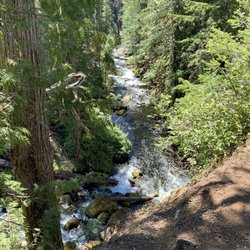
Sahalie and Koosah Falls have been on my waterfall list for a while. We finally made it by last week while visiting the area. We stopped at Sahalie first, and the lot was packed on a Saturday afternoon. Luckily there's some decent parking for bigger rigs right along the highway. If you're there to see one you'll definitely want to see the other too, as there's a path hugging the river between the two...a very heavily trafficked, and at this time of year, muddy path. Sahalie has a great overlook for a straight on view, as well as a short path that takes you to the top of the falls. The water was running fast and hard while we were there, a beautiful and heavy spray should you choose to take a closer look. The trek down to Koosah is short and fairly easy, minus the mud. There's also a wider path just a few steps away from the river one. With all the mud and other viewers we opted to take the alternate path on our return to Sahalie. Not the most impressive falls that OR has to offer. And with the access to both falls and ease from the highway, it sounds like it's a pretty busy path most of the time. But, Sahalie and Koosah are lovely and a must see when in the area.

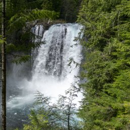
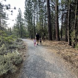
Really pretty hike through trees with awesome waterfall views! Lots of people in the beginning but saw way fewer people doing the loop which was great. Waterfalls were pretty, had some good views of them, would recommend! Parking is a bit tight so be prepared for that, especially if you're coming on a weekend.

There is really not much more you can say, except fantastic, special, amazing, refreshing, beautiful, gorgeous, and so on ..... when it comes to this place. It's a short walk off the road and the small parking, it's far enough from major locations that there is hardly ever big crowds here and the loop hiking trail allows you to explore and see both historic falls, the calm waters at the revisor at the bottom, and various beautiful and magnificent large trees in their natural environment. The entire hike down and up including short excursions and photo opportunities took well under 2 hours. We were so lucky with the weather and the abundance of water coming through from the melting snow and natural underground springs. I want us to go back again sometime soon and see this place again.

See my review for Koosah Falls as it is literally 5 min down the road from this amazing Waterfall. To truly experience this waterfall and Koosah Falls you should hike up along the top and down along the bottom of the falls. Trails are clearly marked. Don't forget to bring a camera cuz there are lots of great sights to capture. Please be courteous and help us keep Oregon beautiful. Please take all garbage (includes uneaten food) back to the parking area where there are garbage bins and bathrooms. Dogs allowed on leash.

Approximately a 2.5 hour beautiful / scenic drive from Portland. As you drive down McKenzie Hwy 126, you'll see clearly marked signs on the side of the road (Sahalie Falls) directing you to the paved parking lot. The parking lot is relatively small and does fill up toward the afternoon. There is a bathroom and map in the parking lot. The bathroom wasn't the cleanest and there's is no light. Minimal parking and space for RV's / trailers. As walk in the parking lot, you can hear the roar of the falls. Take the marked dirt / railed trail 100 yards from the parking lot to the falls viewpoint . Awesome for taking photos , however I found the afternoon to be hard on photos from the viewpoint because of the shadow. Walk a little down pass the viewpoint you'll find roots sticking out the ground from the tress. There's a makeshift path leading down to the falls. That's where you get the BEST view and feel the mist and power of the falls ! Be careful going down. Can be slippery /muddy (see attached photos ). If you go back to the marked trail and continue down you'll hike a nice , easy , flat trail along the river to Koosha Falls (approx. 10-15 mins)! Beautiful scenery for photos along the way (see attached photos). Safe for kids and dogs. Any questions , feel free to message me !


How has it taken me so long to go to Sahalie Falls!? This natural wonder is right off highway 126 and is so easy to get to. The viewpoint is literally steps away from the parking lot on a paved path. The waterfall is gorgeous and so powerful! The trail down to it was closed when we went but some people broke the rules and adventured down to it. We took a trail along the river under the trees. We had our dogs on a leash but it's a pretty narrow trail when it gets crowded. After a little while we decided to make our way back because we weren't sure how far the path went. It was a bit icy when we went last weekend but it was a pretty safe dirt trail with some stairs. Next time when it's less muddy I want to go down to the actual waterfall. There are bathrooms by the parking lot and plenty of parking. I will definitely be going back and would love to go spend the day here exploring!


1 year ago
Sahalie Falls was a quick stop on our way back to Bend from Clear Lake. We were able to find a small parking stall right at the waterfall without having to run across the road with the kids. The walk to the lookout viewing area from the parking lot was very short. We walked a few yards down the trail past it to take pictures of the river. We then took a side trail down to the waterfall to get some pictures. This was a fun quick stop to see a beautiful waterfall. read more


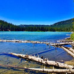
Parking at Sahalie Falls is overcrowded and some folks had to park across the highway. There is a dig out restroom available in the parking lot. The trails are very well maintained and the overlooks offer excellent views of the falls. The path between the falls offers views of the BLUE McKenzie River. Across the river you will see the McKenzie River Trail with runners and hikers. There are several unmaintained paths going from the trail to the river- wander down at your own risk! Definitely a low effort high reward hike! Do not miss this one! read more

This is Sahalie Falls, and not just Sahalie Falls, but also walking along Waterfalls Trail is Koosah Falls. You get 2 for the price of 1 admission! That's a pretty good deal. And I'm not done, lol...4 miles north on Highway 126 is fantastic Tamolitch Falls or otherwise known as Oregon's Blue Pool! So if you're a fan of waterfalls, forests and the great outdoors, this area along the McKenzie River is full of fantastic natural wonders. Before diving into the details about Sahalie Falls, I'll just mention I spent 1 full day hiking to the Blue Pool in the morning and then venturing over here around 3:30pm for some waterfalls' sightseeing. It made for a glorious day surrounded by nature at its finest. For late afternoon at the end of July, I was barely able to grab a parking spot in the small lot, and I'm convinced that had I arrived after 9am in the morning, I would have been out of luck and forced to park somewhere along the shoulder of Highway 126 (which isn't so bad I guess). Looking at the trailhead sign, it showed that you can hit Sahalie Falls first and then continue along the charming Waterfalls Trail for less than 1 mile more to catch Koosah Falls as well. How easy and convenient is that!? And to be specific, Sahalie Falls is located right behind the trailhead sign. Before even getting started, the action comes to you. The viewpoint on the paved path offers a clear perspective of Sahalie Falls. But wait, it gets better... You can also (which I did) easily walk off the pathway and venture down below to the base of Sahalie Falls. It's not dangerous or forbidden. I noticed someone doing it and had to climb over the short railing and copy their idea. At the bottom of Sahalie Falls, there's plenty of walking space surrounded by lush, green grass. Then, climbing up the small mound and Sahalie Falls smacks you square in the face. It's like a one-on-one moment with a tour de force, lol. You can feel the powerful rush of the waterfall, especially sprayed by mist. It's about as close as you can get to a waterfall without standing underneath it. I suggest climbing over the railing. It makes the experience more rewarding. I won't get into much detail about Koosah Falls since I noticed there's a separate section for writing about it. I'll just say that it's mandatory for visiting both waterfalls. And Koosah Falls is impressive. Some last notes off the top of my head about Sahalie Falls... - It's free to visit. - The Waterfalls Trail path isn't elevated and overall is pleasant to walk. You're among the forest trees and for summertime, the setting was quiet. - There are random points along Waterfalls Trail to stop and admire the gushing McKenzie River. - It wasn't crowded for late afternoon on July, 31. - I had no cell phone reception. - This McKenzie Highway 126 is full of roadside stops offering hiking, camping, picnicking and day use recreations. You feel far from reality when in essence there's a major town located in any direction. I'm glad I got a chance to write about Sahalie Falls, it's yet another unheralded Oregon waterfall that shouldn't be missed. I tell ya, Oregon is my new favorite state, lol. It's a waterfall enthusiasts' dream come true. read more


This review is for Koosah And Sahalie Falls Trail which was a ~2.4 miles round trip that took ~1.5 hours to complete. Stunning views of the river, waterfall and trees! Limited parking spots! Short video of the hike for those interested! https://youtu.be/rCbdalggxEA read more


Sahalie and Koosah Falls have been on my waterfall list for a while. We finally made it by last week while visiting the area. We stopped at Sahalie first, and the lot was packed on a Saturday afternoon. Luckily there's some decent parking for bigger rigs right along the highway. If you're there to see one you'll definitely want to see the other too, as there's a path hugging the river between the two...a very heavily trafficked, and at this time of year, muddy path. Sahalie has a great overlook for a straight on view, as well as a short path that takes you to the top of the falls. The water was running fast and hard while we were there, a beautiful and heavy spray should you choose to take a closer look. The trek down to Koosah is short and fairly easy, minus the mud. There's also a wider path just a few steps away from the river one. With all the mud and other viewers we opted to take the alternate path on our return to Sahalie. Not the most impressive falls that OR has to offer. And with the access to both falls and ease from the highway, it sounds like it's a pretty busy path most of the time. But, Sahalie and Koosah are lovely and a must see when in the area. read more


Such a beautiful stop off the McKenzie Hwy. Free parking and a trail that is easy to navigate for people of all ages and abilities. Wear a good pair of walking shoes as part of the trail are slightly uneven. Overall great trip that can be enjoyed for a few hours of fun. read more


Really pretty hike through trees with awesome waterfall views! Lots of people in the beginning but saw way fewer people doing the loop which was great. Waterfalls were pretty, had some good views of them, would recommend! Parking is a bit tight so be prepared for that, especially if you're coming on a weekend. read more

There is really not much more you can say, except fantastic, special, amazing, refreshing, beautiful, gorgeous, and so on ..... when it comes to this place. It's a short walk off the road and the small parking, it's far enough from major locations that there is hardly ever big crowds here and the loop hiking trail allows you to explore and see both historic falls, the calm waters at the revisor at the bottom, and various beautiful and magnificent large trees in their natural environment. The entire hike down and up including short excursions and photo opportunities took well under 2 hours. We were so lucky with the weather and the abundance of water coming through from the melting snow and natural underground springs. I want us to go back again sometime soon and see this place again. read more

See my review for Koosah Falls as it is literally 5 min down the road from this amazing Waterfall. To truly experience this waterfall and Koosah Falls you should hike up along the top and down along the bottom of the falls. Trails are clearly marked. Don't forget to bring a camera cuz there are lots of great sights to capture. Please be courteous and help us keep Oregon beautiful. Please take all garbage (includes uneaten food) back to the parking area where there are garbage bins and bathrooms. Dogs allowed on leash. read more


Approximately a 2.5 hour beautiful / scenic drive from Portland. As you drive down McKenzie Hwy 126, you'll see clearly marked signs on the side of the road (Sahalie Falls) directing you to the paved parking lot. The parking lot is relatively small and does fill up toward the afternoon. There is a bathroom and map in the parking lot. The bathroom wasn't the cleanest and there's is no light. Minimal parking and space for RV's / trailers. As walk in the parking lot, you can hear the roar of the falls. Take the marked dirt / railed trail 100 yards from the parking lot to the falls viewpoint . Awesome for taking photos , however I found the afternoon to be hard on photos from the viewpoint because of the shadow. Walk a little down pass the viewpoint you'll find roots sticking out the ground from the tress. There's a makeshift path leading down to the falls. That's where you get the BEST view and feel the mist and power of the falls ! Be careful going down. Can be slippery /muddy (see attached photos ). If you go back to the marked trail and continue down you'll hike a nice , easy , flat trail along the river to Koosha Falls (approx. 10-15 mins)! Beautiful scenery for photos along the way (see attached photos). Safe for kids and dogs. Any questions , feel free to message me ! read more


How has it taken me so long to go to Sahalie Falls!? This natural wonder is right off highway 126 and is so easy to get to. The viewpoint is literally steps away from the parking lot on a paved path. The waterfall is gorgeous and so powerful! The trail down to it was closed when we went but some people broke the rules and adventured down to it. We took a trail along the river under the trees. We had our dogs on a leash but it's a pretty narrow trail when it gets crowded. After a little while we decided to make our way back because we weren't sure how far the path went. It was a bit icy when we went last weekend but it was a pretty safe dirt trail with some stairs. Next time when it's less muddy I want to go down to the actual waterfall. There are bathrooms by the parking lot and plenty of parking. I will definitely be going back and would love to go spend the day here exploring! read more


5 years ago
8 years ago
Even the rain couldn't stop me and my family from coming here. This place is so beautiful. Definitely worth coming here! Site is just gorgeous! read more

5 years ago
8 years ago
Beautiful and deserted early in the morning. You can and should walk the trail to the nearby Koosah Falls, too... Lush surroundings. read more

9 years ago
Sahalie Falls is right off highway 126, it's quick, it's easy, and it gets busy! If you are limited on time and in the area you should add this fall to your to-do list. I like to hike the trail from Sahalie to Koosah Falls when I am taking a friend to Tamolitch Pool as it is along the way or when I am taking the family on a tour of central Oregon and want to save some time. The fall itself is quite majestic but for this area pretty standard, green, wet, and beautiful. If you visit Sahalie first you will be in awe, but if you start somewhere else you might feel less impressed as there is allot of competition on this trail for awe inspiring sights and this one is typically packed with people. One of my favorite things about this fall is the impact the noise from the fall makes when it hits your chest. It really has some CFS to it. Another favorite is the mist it creates on a hot summer day, it really cools you off. Overall this fall is great for time and beauty, but if you are wanting something a little less populated you may want to consider some of the other falls along this trial, just start hiking, you will find them! read more


More info about Sahalie Falls
Hwy 126
Sisters, OR 97128
Directions
Visit Website
http://www.oregon.com/recreation/hike-sahalie-falls
Hours
Indoor Amenities
Outdoor Amenities
Ask the Community - Sahalie Falls
Is there a fee to visit this park? Are there any loose dogs there? I won't take my dog where there are loose and dangerous dogs.
You will need a Northwest Forest Pass to visit the falls. Dogs are required to be on leash, whether…
Review Highlights - Sahalie Falls


Sahalie Falls - hiking - Updated August 2026
Best of Sisters
People found Sahalie Falls by searching for…
Hiking Trails With Waterfalls in Sisters, OR
Dog Friendly Parks in Sisters, OR
Dog Friendly Hiking Trails in Sisters, OR
Scenic Overlook in Sisters, OR
Off Leash Dog Hiking Trails in Sisters, OR
Fun Things to Do With Kids in Sisters, OR
Dog Friendly Things to Do in Sisters, OR
Hiking With Kids in Sisters, OR
Hikes With Dogs in Sisters, OR
Off Road Trails in Sisters, OR
Trending Searches in Sisters, OR
Cliff Jumping near Sahalie Falls
Dog Swimming near Sahalie Falls
Flower Fields near Sahalie Falls
Kayak Rental near Sahalie Falls
Kids Activities Indoor near Sahalie Falls
Outdoor Activities near Sahalie Falls
Picnic Areas near Sahalie Falls
River Swimming near Sahalie Falls
River Tubing near Sahalie Falls
Rock Quarry near Sahalie Falls
Scenic Overlook near Sahalie Falls
Shopping Malls near Sahalie Falls
Soccer Fields near Sahalie Falls
Sunrise View near Sahalie Falls
Swimming Holes near Sahalie Falls
Teen Clothing Stores near Sahalie Falls
Browse Articles
Browse Nearby
Browse Brands
Related Searches in Sisters, OR
Affordable Kayak Rental Services in Sisters, Oregon
Best Dog Hiking Trails Around Sisters, Oregon
Best Fishing Locations and Guides in Sisters, Oregon
Best Fun Things to Do in Sisters, Oregon
Best Places for Horseback Riding in Sisters, Oregon
Best Sightseeing Experiences Available in Sisters, Oregon
Best Waterfalls and Swimming Holes in Sisters, Oregon
Discover Dog Friendly Trails to Explore in Sisters, Oregon
Discover the Best Night Hike Trails in Sisters, Oregon
Dog-Friendly Hikes With Dogs in Sisters, Oregon
Enjoy Camping Adventures Around Sisters, Oregon
Enjoy Kayaking Adventures in Sisters, Oregon
Enjoy Off Leash Dog Hikes in Sisters, Oregon
Enjoy Tent Camping Spots Around Sisters, Oregon
Enjoy Water Activities and Fun in Sisters, Oregon
Enjoy the Best Walking Path in Sisters, Oregon
Enjoy the Best Walking Trails in Sisters, Oregon
Experience Thrilling White Water Rafting in Sisters, Oregon
Explore Beautiful Parks and Green Spaces in Sisters, Oregon
Explore Easy Hikes Perfect for All in Sisters, Oregon
Explore Fun Activities to Do in Sisters, Oregon
Explore Popular Campgrounds Near Sisters, Oregon
Explore Scenic Lakes to Visit in Sisters, Oregon
Explore Top Dog Parks in Sisters, Oregon Near You
Explore Top Water Parks in Sisters, Oregon Today
Explore the Best Beach Spots in Sisters, Oregon
Explore the Best Swimming Holes Around Sisters, Oregon
Family Friendly Hiking With Kids in Sisters, Oregon
Find Parks and Recreation Activities in Sisters, Oregon
Find Top-Rated Waterfalls in Sisters, Oregon Now
Find the Best Playgrounds to Visit in Sisters, Oregon
Find the Best Scenic View Locations in Sisters, Oregon
Hiking Trails With Waterfalls in Sisters, Oregon
Off Leash Dog Hiking Trails in Sisters, Oregon
Perfect Spots to Watch Sunset in Sisters, Oregon
Popular Outdoor Activities to Try in Sisters, Oregon
Popular Picnic Spots to Visit in Sisters, Oregon
Safe River Swimming Areas in Sisters, Oregon
Safe and Fun Parks for Kids in Sisters, Oregon
Top Hiking Trails to Explore in Sisters, Oregon
Top Playgrounds for Kids to Enjoy in Sisters, Oregon
Top Running Trails to Explore in Sisters, Oregon
Top Swimming Lakes to Enjoy in Sisters, Oregon
Top Swimming Spots and Pools in Sisters, Oregon
Top Things to Do With Kids in Sisters, Oregon
Top-Rated Camping Sites in Sisters, Oregon


