Metolius Preserve Photos


More like Metolius Preserve
Recommended Reviews - Metolius Preserve
Start your review...

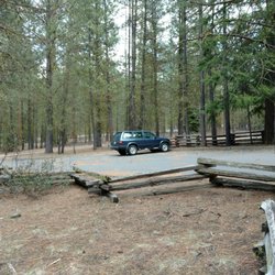
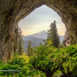
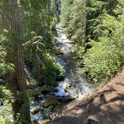
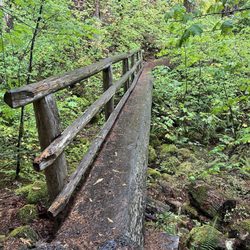
I found the preserve on articles when researching where I could check out larches as they turn yellow. We'd been hiking around Camp Sherman before, but didn't even know the Metolius Preserve existed. There are 2 trailheads, North and South, each with parking. We chose to park at the North Trailhead, as we'd chosen to take the Larch Trail this day. There's a good amount of parking, and nice gravel roads throughout. Trails and trail intersections are signed well. The 10 miles of trails here are for hikers and bikes, although we only met a couple of each while there. The Preserve grounds are very pretty and serene. Gorgeous trees and fall colors (including turning larches) abound, as well as birds and the occasional critter in the brush. Everything we encountered while there was well-maintained and clean. Can't wait to check out the other trails. read more


More info about Metolius Preserve
Camp Sherman, OR 97730
Directions
Hours
Outdoor Amenities


Metolius Preserve - hiking - Updated May 2026
Best of Camp Sherman
People found Metolius Preserve by searching for…
Things to Do in Camp Sherman, Oregon
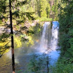
Hiking Trails With Waterfalls in Camp Sherman, Oregon
Easy Hikes in Camp Sherman, Oregon
View Points in Camp Sherman, Oregon
Sunset View in Camp Sherman, Oregon
Scenic Overlook in Camp Sherman, Oregon
Walking Trails in Camp Sherman, Oregon
Dog Friendly Trails in Camp Sherman, Oregon
Scenic Views in Camp Sherman, Oregon
Waterfalls in Camp Sherman, Oregon
Lakes & Ponds in Camp Sherman, Oregon
Off Leash Dog Hikes in Camp Sherman, Oregon
Sunrise View in Camp Sherman, Oregon
Stargazing in Camp Sherman, Oregon
Swimming Lakes in Camp Sherman, Oregon
Free Campgrounds in Camp Sherman, Oregon
Lookout Points in Camp Sherman, Oregon
Sunrise Hike in Camp Sherman, Oregon
Secluded Spots in Camp Sherman, Oregon
Fall Colors in Camp Sherman, Oregon
Trending Searches in Camp Sherman, OR
Boat Rental near Metolius Preserve
Bounce House Rentals near Metolius Preserve
Campgrounds near Metolius Preserve
Cheap Plants near Metolius Preserve
Cliff Jumping near Metolius Preserve
Dog Friendly Trails near Metolius Preserve
Flower Fields near Metolius Preserve
Flower Shop near Metolius Preserve
Garden Center near Metolius Preserve
Lakes & Ponds near Metolius Preserve
Nurseries & Gardening near Metolius Preserve
Outdoor Furniture Stores near Metolius Preserve
Party Equipment Rentals near Metolius Preserve
Pedicure near Metolius Preserve
Photo Spots near Metolius Preserve
Places To Take Pictures near Metolius Preserve
Rv Rental near Metolius Preserve
Swimming Holes near Metolius Preserve
Table And Chair Rentals near Metolius Preserve
Browse Articles
Browse Nearby
BEST of Camp Sherman, Oregon Things to Do near Metolius Preserve
BEST of Camp Sherman, Oregon Coffee near Metolius Preserve
BEST of Camp Sherman, Oregon Waterfalls near Metolius Preserve
BEST of Camp Sherman, Oregon Restaurants near Metolius Preserve
BEST of Camp Sherman, Oregon Swimming Holes near Metolius Preserve
BEST of Camp Sherman, Oregon Hotels near Metolius Preserve
BEST of Camp Sherman, Oregon Campgrounds near Metolius Preserve
BEST of Camp Sherman, Oregon Breakfast near Metolius Preserve
BEST of Camp Sherman, Oregon Sledding near Metolius Preserve
Browse Brands
Related Searches in Camp Sherman, OR
Best Fishing Locations and Guides in Camp Sherman, Oregon
Best Nature Trails for Hiking in Camp Sherman, Oregon
Best Off Leash Dog Parks in Camp Sherman, Oregon
Best Places for Horseback Riding in Camp Sherman, Oregon
Best Sledding Spots and Fun in Camp Sherman, Oregon
Check Out Off Road Trails in Camp Sherman, Oregon
Discover Lakes & Ponds to Explore in Camp Sherman, Oregon
Discover Popular Bike Trails in Camp Sherman, Oregon
Discover Top Nature Parks to Visit in Camp Sherman, Oregon
Discover a Hiking Trail in Camp Sherman, Oregon
Discover the Best Running Track in Camp Sherman, Oregon
Enjoy Camping Adventures Around Camp Sherman, Oregon
Enjoy Scenic Night View Experiences in Camp Sherman, Oregon
Enjoy Tent Camping Spots Around Camp Sherman, Oregon
Enjoy the Best Night View Spots in Camp Sherman, Oregon
Enjoy the Best Picnic Spots and Ideas in Camp Sherman, Oregon
Enjoy the Best Walking Trails in Camp Sherman, Oregon
Exciting Cliff Jumping Spots in Camp Sherman, Oregon
Experience Stunning Sunset Views in Camp Sherman, Oregon
Explore Beautiful Parks and Green Spaces in Camp Sherman, Oregon
Explore Bike Rentals Throughout Camp Sherman, Oregon
Explore Easy Hikes Perfect for All in Camp Sherman, Oregon
Explore Popular Scenic Overlook Points in Camp Sherman, Oregon
Explore Popular View Points Around Camp Sherman, Oregon
Explore Scenic Lakes to Visit in Camp Sherman, Oregon
Explore Secret Spots Worth Visiting in Camp Sherman, Oregon
Explore Top Dog Parks in Camp Sherman, Oregon Near You
Explore the Best Swimming Holes Around Camp Sherman, Oregon
Explore the Best Trail Options in Camp Sherman, Oregon
Family Friendly Hiking With Kids in Camp Sherman, Oregon
Find Beautiful Views in Camp Sherman, Oregon
Find Cozy Camping Cabins in Camp Sherman, Oregon
Find Fun Kids Activities Outdoor in Camp Sherman, Oregon
Find the Best Parks for Picnics in Camp Sherman, Oregon
Find the Best Scenic View Locations in Camp Sherman, Oregon
Find the Best Swimming Pools in Camp Sherman, Oregon Today
Hiking Trails With Waterfalls in Camp Sherman, Oregon
Perfect Spots to Watch Sunset in Camp Sherman, Oregon
Picnic Areas With BBQ Pits Available in Camp Sherman, Oregon
Plan Nature Center Visits in Camp Sherman, Oregon
Plan a Scenic Drive Route Near Camp Sherman, Oregon
Popular Fishing Spots to Explore in Camp Sherman, Oregon
Popular Kids Activities in Camp Sherman, Oregon
Popular Places to Take Pictures in Camp Sherman, Oregon
Popular Things to Do in Camp Sherman, Oregon
Safe River Swimming Areas in Camp Sherman, Oregon
Top Paddleboarding Activities in Camp Sherman, Oregon
Top Running Trails to Explore in Camp Sherman, Oregon