Virgin River Trail Photos


More like Virgin River Trail
Recommended Reviews - Virgin River Trail
Start your review...

Reviews With Photos

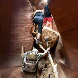
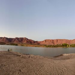
Previous reviews mention the larger trail, in which many bike on, with no real beginning or end-just enjoying & following the expansive river side. For our experience, we parked near a trailhead, descending down a hillside path, towards the water edge. As we walked, there were gorgeous sunset views of the mountains and river below. There were large patches of volcanic rocks, which can be nice for just viewing, but we enjoyed climbing up them to obtain higher views. There was a portion of the trail covered in what appeared to be prior historical flood landslide garbage & broken glass, so be weary when walking-especially with pets- but it was only a short portion. We didn't make it all the way down to the river, as we went later in the evening, we merely enjoyed finding a high point to watch the sunset. The decline, then return uphill, wasn't too steep making this an easy enjoyable walk.

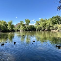
The Virgin River Trail is easy, fun and if you have a bike a must. I pass through St George if not every week, every other week and made a promise to myself that I need to bring my bike with me more often because there are some neat biking trails in Utah. This trail certainly can be traveled by foot, which hubby and I did this first time. The trail is paved well and markers and signs are posted along the way. There were many people walking the trail and riding their bikes and every person waved, said hello or stopped to chit chat about the area. One passerby said the trail was flooded in 2010, causing portions of the trail to be closed however construction is finished and the trail is fully open again. We had some trouble at first locating a trailhead where we could start out. I got out my phone and was able to pull up these directions from the internet to the Man O' War trailhead: From I-15 take Exit 4 onto W. Brigham and go to the traffic circle; exit on Pioneer Road and head 0.6 mile to right turn on Man O' War Road. Continue another 0.7 mile to entrance, (first right after crossing Virgin River), Man O' War Road trailhead. Along the trail I noticed water fountains (winterized at the time), trash cans, benches and areas with bars just in case you want to stop and do pull-ups along your journey. As far as wildlife goes, I only saw numerous birds. The only real complaint I have is the sewage smell during some parts of the walk. It was reeky! This visit we made it as far as the pedestrian bridge and had to turn around because it was getting dark and we had no flashlights (about 1.5 hours round-trip). There is nothing strenuous about this hike and it is a great starter trail for young kids. Pack a lunch and plan to stop and have a bite to eat at one of the benches/tables along the way!

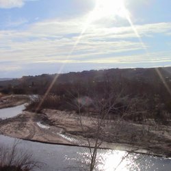
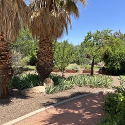
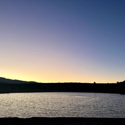
Sometimes we aren't in the mood for a true "hike" where you have to navigate trails, climb an incline or commit to a strenuous activity. There are times when we prefer a leisurely stroll, likely at the end of a dog leash, and the Virgin River Trail is just perfect for that! There's ample parking and restrooms at the park, then you can hop on the trail in a variety of directions. The path is paved and very clearly marked, so you know where to go. There are even signs along the way directing to different trails as well as information about the length. I especially like the bridges over the Virgin River-they make for a nice photo. Not a lot of shade, so if you're walking in the summer months, prepare for that. read more


1 year ago
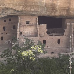
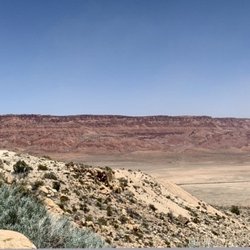
I had an idyllic escape to St. George, UT during my spring break staycation back in March. After arriving in St. George, I beelined to Confluence Park to bike the Virgin River Trail, which parallels the Virgin River for nearly 12 miles. The trail is well-maintained, extremely scenic, passes through diverse Southwestern landscapes, and is relatively flat (with the exception of the detour I took through picturesque Cottonwood Canyon on the Hell Hole Trail). Biking the Virgin River North Trail out and back from Confluence Park is roughly 18.2 miles. I did an extra seven miles on the Hell Hole & Virgin River South Trails to get me closer to 25 miles total. During my bike ride, I encountered photographers, runners, hikers, other bicyclists, and families/groups of people out on leisurely strolls. I would rate the Virgin River Trail as easy and suitable for all fitness levels. I found Cottonwood Canyon and the steep Hell Hole Trail hard/difficult as a novice biker, but well worth the effort! After my bike ride and lunch in St. George, the adventure continued with a scenic drive back home through the Virgin River Gorge (AZ), Moapa Valley (NV), and Lake Mead National Recreation Area (NV). read more


3 years ago
What a nice trail. Went off the path down to the river. My dog had a blast running around like a madman. The trail has dog poop bags even spots to fill up your bike with air in the tires. read more

3 years ago
Previous reviews mention the larger trail, in which many bike on, with no real beginning or end-just enjoying & following the expansive river side. For our experience, we parked near a trailhead, descending down a hillside path, towards the water edge. As we walked, there were gorgeous sunset views of the mountains and river below. There were large patches of volcanic rocks, which can be nice for just viewing, but we enjoyed climbing up them to obtain higher views. There was a portion of the trail covered in what appeared to be prior historical flood landslide garbage & broken glass, so be weary when walking-especially with pets- but it was only a short portion. We didn't make it all the way down to the river, as we went later in the evening, we merely enjoyed finding a high point to watch the sunset. The decline, then return uphill, wasn't too steep making this an easy enjoyable walk. read more


5 years ago
2 years ago
13 years ago
The Virgin River Trail is easy, fun and if you have a bike a must. I pass through St George if not every week, every other week and made a promise to myself that I need to bring my bike with me more often because there are some neat biking trails in Utah. This trail certainly can be traveled by foot, which hubby and I did this first time. The trail is paved well and markers and signs are posted along the way. There were many people walking the trail and riding their bikes and every person waved, said hello or stopped to chit chat about the area. One passerby said the trail was flooded in 2010, causing portions of the trail to be closed however construction is finished and the trail is fully open again. We had some trouble at first locating a trailhead where we could start out. I got out my phone and was able to pull up these directions from the internet to the Man O' War trailhead: From I-15 take Exit 4 onto W. Brigham and go to the traffic circle; exit on Pioneer Road and head 0.6 mile to right turn on Man O' War Road. Continue another 0.7 mile to entrance, (first right after crossing Virgin River), Man O' War Road trailhead. Along the trail I noticed water fountains (winterized at the time), trash cans, benches and areas with bars just in case you want to stop and do pull-ups along your journey. As far as wildlife goes, I only saw numerous birds. The only real complaint I have is the sewage smell during some parts of the walk. It was reeky! This visit we made it as far as the pedestrian bridge and had to turn around because it was getting dark and we had no flashlights (about 1.5 hours round-trip). There is nothing strenuous about this hike and it is a great starter trail for young kids. Pack a lunch and plan to stop and have a bite to eat at one of the benches/tables along the way! read more


4 years ago
13 years ago
This is a cool trail. It is simple to walk or ride a bike on. A lot of it is paved. All ages can enjoy this trail. While walking I saw a old water pump that was interesting. Then there was part of a golf course (the old water pump used to supply the water to it) and even some residential houses. Of course the Virgin River was visible along the way. At the pedestrian bridge I got hungry seeing a billboard for In N Out Burger near the highway. Torture! At the Man O War trailhead there is a well paved parking lot and a board showing the trail and known animals/fish in the area. Dogs are allowed on leash. read more


8 years ago
13 years ago
More info about Virgin River Trail
Convention Center Dr
St. George, UT 84790
Directions
(435) 627-4000
Call Now
Visit Website
http://www.sgcity.org
Hours
Indoor Amenities
Outdoor Amenities
Ask the Community - Virgin River Trail
Review Highlights - Virgin River Trail


Virgin River Trail - hiking - Updated June 2026
Best of St. George
People found Virgin River Trail by searching for…
Things to Do in St. George, Utah
Scenic Drive in St. George, Utah
Watch Sunset in St. George, Utah
Hiking Trails in St. George, Utah
Scenic View in St. George, Utah
Walking Trails in St. George, Utah
Fishing Spots in St. George, Utah
Fun Things to Do at Night in St. George, Utah
Off Road Trails in St. George, Utah
Dog Friendly Things to Do in St. George, Utah
Off Leash Dog Hiking Trails in St. George, Utah
View Points in St. George, Utah
River Walk in St. George, Utah
Bike Paths in St. George, Utah
Trending Searches in St. George, UT
Boat Rental near Virgin River Trail
Cliff Jumping near Virgin River Trail
Day Trips near Virgin River Trail
Dog Friendly Trails near Virgin River Trail
Fireworks near Virgin River Trail
Fishing Spots near Virgin River Trail
Jet Ski Rental near Virgin River Trail
Kayak Rental near Virgin River Trail
Outdoor Activities near Virgin River Trail
Pool Day Pass near Virgin River Trail
Public Pools near Virgin River Trail
Public Shower near Virgin River Trail
River Swimming near Virgin River Trail
River Tubing near Virgin River Trail
Scenic Night View near Virgin River Trail
Scenic Overlook near Virgin River Trail
Splash Pad near Virgin River Trail
Sunrise View near Virgin River Trail
Swimming Holes near Virgin River Trail
Swimming Lakes near Virgin River Trail
Watch Sunset near Virgin River Trail
Browse Articles
Browse Nearby
BEST of St. George, Utah Coffee near Virgin River Trail
BEST of St. George, Utah Restaurants near Virgin River Trail
BEST of St. George, Utah Things to Do near Virgin River Trail
BEST of St. George, Utah Hot Springs near Virgin River Trail
BEST of St. George, Utah Breakfast near Virgin River Trail
BEST of St. George, Utah Walking Trails near Virgin River Trail
BEST of St. George, Utah Parks near Virgin River Trail
BEST of St. George, Utah Campgrounds near Virgin River Trail
BEST of St. George, Utah Visitor Centers near Virgin River Trail
Browse Brands
Related Searches in St. George, UT
Affordable Kayak Rental Services in St. George, Utah
Best Fishing Locations and Guides in St. George, Utah
Best Places for Horseback Riding in St. George, Utah
Check Out Off Road Trails in St. George, Utah
Discover Dog Friendly Trails to Explore in St. George, Utah
Discover Kid Friendly Hiking Trails in St. George, Utah
Discover a Hiking Trail in St. George, Utah
Discover the Best Night Hike Trails in St. George, Utah
Enjoy Camping Adventures Around St. George, Utah
Enjoy Exciting Mountain Biking Adventures in St. George, Utah
Enjoy Kayaking Adventures in St. George, Utah
Enjoy Tent Camping Spots Around St. George, Utah
Enjoy the Best Family Activities in St. George, Utah
Enjoy the Best Picnic Spots and Ideas in St. George, Utah
Enjoy the Best Walking Trails in St. George, Utah
Explore Beautiful Parks and Green Spaces in St. George, Utah
Explore Bike Rentals Throughout St. George, Utah
Explore Easy Hikes Perfect for All in St. George, Utah
Explore Fun Activities to Do in St. George, Utah
Explore Popular Campgrounds Near St. George, Utah
Explore Popular RV Parks Around St. George, Utah
Explore Scenic Lakes to Visit in St. George, Utah
Explore Top Dog Parks in St. George, Utah Near You
Explore Top Water Parks in St. George, Utah Today
Explore the Best Boating Spots in St. George, Utah
Explore the Best Swimming Holes Around St. George, Utah
Family Friendly Hiking With Kids in St. George, Utah
Find Beautiful Views in St. George, Utah
Find Popular Ziplining Spots Around St. George, Utah
Find the Best Playgrounds to Visit in St. George, Utah
Find the Best Scenic View Locations in St. George, Utah
Hiking Trails With Waterfalls in St. George, Utah
Off Leash Dog Hiking Trails in St. George, Utah
Perfect Spots to Watch Sunset in St. George, Utah
Plan a Scenic Drive Route Near St. George, Utah
Popular Fishing Spots to Explore in St. George, Utah
Popular Outdoor Activities to Try in St. George, Utah
Popular Picnic Spots to Visit in St. George, Utah
Popular Things to Do in St. George, Utah
Popular Things to See in St. George, Utah
Safe River Swimming Areas in St. George, Utah
Safe and Fun Parks for Kids in St. George, Utah
Top Climbing Spots and Gyms in St. George, Utah
Top Paddleboarding Activities in St. George, Utah
Top Playgrounds for Kids to Enjoy in St. George, Utah
Top Running Trails to Explore in St. George, Utah
Top Swimming Lakes to Enjoy in St. George, Utah
Top Swimming Spots and Pools in St. George, Utah