1. Vermilion Cliffs National Monument

0

St. George, UT

Cancel

Open app

Search

Vermilion Cliffs National Monument

5.0 (1 review)
Open • 7:45 am - 5:00 pm

Vermilion Cliffs National Monument Photos

You might also consider

More like Vermilion Cliffs National Monument

Recommended Reviews - Vermilion Cliffs National Monument

Your trust is our priority, so businesses can't pay to alter or remove their reviews. Learn more about reviews.
Yelp app icon
Browse more easily on the app
Review Feed Illustration

4 years ago

Helpful 7
Thanks 0
Love this 8
Oh no 0

Verify this business for free

People searched for Hiking 386 times last month within 15 miles of this business.

Verify this business

Paria Canyon-Vermilion Cliffs Wilderness - Buckskin Gulch

Paria Canyon-Vermilion Cliffs Wilderness

5.0(2 reviews)
0.0 mi

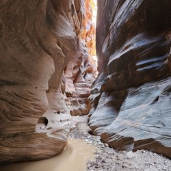
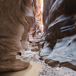
Like the other reviewer, I went to the Wire Pass trail. As you hike the wash, you pass by the…read moreCoyote Buttes North trailhead, aka The Wave, but don't be tempted to go if you don't have a permit! The rangers will catch you! To get to here, you will need to drive on House Rock Valley Road which is an unpaved road. I did it in a 2WD sedan, but made sure that the weather was dry so there was no mud. There's a large parking lot with a few composting toilets. You do need to pay for a permit - the trailhead allows you to use your credit card to pay and prints out a copy of the permit. Anyway, this is an awesome slot canyon! Follow the stream bed until you enter the canyon. It's a short canyon that leads to a petroglyph panel. There's a ladder section, but also an alternative trail if you have a dog or can't navigate the ladder. At the petroglyph panel, you can then explore the Buckskin Gulch narrows (the full Gulch is an overnight hike). I had to turn around at some point since there were huge puddles of water - some over knee deep that I didn't want to risk accidentally falling into when balancing on rocks. I would definitely visit again!!!

Paria Canyon-Vermillion Cliffs is a designated wilderness area within the Vermillion Cliffs…read moreNational Monument, which straddles the border between Utah and Arizona and is approximately 40 miles East of Kanab, UT. This wilderness area wraps around the northern side of the monument and encompasses the Paria River canyon and other smaller, connected canyons. It is also the site of the famous landmark known as "The Wave," though that area (called 'Coyote Buttes North') is only accessible via permit; and such a permit can only obtained via a lottery system. But if, like us, you don't win that lottery, this beautiful area still has plenty to offer, namely: stunning slot canyon hiking. PCVC wilderness area is accessible via three trail-heads on two different roads off Hwy 89. We chose the Wire Pass trail-head off House Rock Road, which involved just over 20 miles of driving on a winding, sandy (and sometimes rutted) dirt road off the highway. (Note: this road is not passable after heavy rain). Our destination was the Paria River canyon itself, which can be reached from the the trail-head by passing through Wire Pass. Long story short, our hike was beautiful. Wire Pass itself narrowed from a wide 'wash' to a narrow slot canyon about 50 ft high, and we could feel the temperature drop about 10 degrees as we entered the latter. There was at least one semi-treacherous spot where a steep, blind climb-down over a large rock was required (I was glad to have long legs). The canyon opened up a bit at the confluence with Paria River canyon, before transforming again into a wider but much deeper slot canyon downstream. But due to the dangers of flooding in this narrow space, we ended up turning back before our planned turnaround point, since we sighted (and heard) some big thunderheads about 20 miles or so upstream. (We agreed not to die of stupidity). But we still had a great day. Other things you should know before visiting Paria Canyon-Vermillion Cliff Wilderness: -- A permit is needed for backpacking overnight in Paria Canyon -- Don't think you can just sneak over to 'The Wave' without a permit. It is patrolled daily; and fines range from $1k to $10k. They've even been known to impound vehicles -- If hiking a long distance in Paria canyon, you will get wet; wading through some deep pools may be required (so bring water shoes and hiking poles) -- All poop must be packed out (You heard me) -- Local monsoon season is June - Sept; best avoided for flash flooding

Photos
Paria Canyon-Vermilion Cliffs Wilderness - Buckskin Gulch

Buckskin Gulch

Paria Canyon-Vermilion Cliffs Wilderness - Trailhead bathrooms - none on the trail itself (duh)

Trailhead bathrooms - none on the trail itself (duh)

Paria Canyon-Vermilion Cliffs Wilderness - Trailhead bathrooms - none on the trail itself (duh)

See all

Trailhead bathrooms - none on the trail itself (duh)

Vermillion Cliffs National Monument

Vermillion Cliffs National Monument

4.7(6 reviews)
0.0 mi

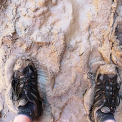
VIRGIN ON TRAIL, in other words, my first BACKPACKING TRIP!!!!…read more The Stats: Distance: About 10 miles Elevation Gain: less than 500 feet Rating: 2/10 (w/o pack) difficulty increases as the pack weight increases Trail: Open Canyon Duration: 4-6 hours Water Warning: Ankle deep water, quicksand sloppy mud Camping Fees: $4.00-$10.00 Essentials: As little as possible (no more than 30% of your total weight) Must be able to be self-sustaining for number of days Recommended items Clothing Dehydrated food Water (there are springs where water can be filtered, you just have to find them) Water filter Tent Sleeping pad & bag Camping towel Hiking Poles For a more complete list check out http://www.blm.gov/az/st/en/arolrsmain/paria/checklist.html Waste information: http://www.blm.gov/az/st/en/arolrsmain/paria/pack_in_out.html Background Paria means "muddy water" in the Paiute Indian language. Hikers must wade through the muddy waters of the wild and twisting canyon. One hiker counted approximately 300 river crossings. Boulders and other obstacles increase the challenge. The 112,000 acre Paria Canyon-Vermillion Cliffs Wilderness was established by the Arizona Wilderness Act of 1984. Located along the Arizona-Utah border, it contains public lands in Kane and Coconino counties. Paria Canyon is managed by two federal agencies, the Bureau of Land Management--Vermillion and Kanab Resource Areas, and the National Park Service--Glen Canyon National Recreation Area. The BLM is required to preserve the area's natural conditions, outstanding opportunities, for solitude and primitive recreation, and the area's educational, scenic, and historical values. This is accomplished through required management of a variety of uses such as hiking, backpacking, hunting, and livestock grazing. More restrictive visitor use limits may at times be needed to protect wilderness resources, which is the top priority when a choice must be made between preservation and visitation. Our Route After a night's sleep in St. George, UT, me and The Crew caravanned our weekend adventure, camping for two nights in Paria Canyon with a day night through Buckskin Gulch. Before heading off to a land of no cell service, electricity, or any other form of service and comforts of home, we stop by the Visitors Center at the Coyote Buttes Permit Area in Arizona to pick up our permit. Permits are restricted to 10 people, quarters are close so choose wisely. Our day on trail begins in a dirt parking lot where we make any last minute adjustments to our oversized packs, which should not be more than 30% of our overall weight. Fortunately one hiker brought a luggage scale and we were able to weigh in our packs. My was 34 lbs., which is a bit under the 30% Woo Hoo!! Not bad for a virgin to backpacking. 9:30ish a.m. we headed off to our weekend "hotel". Through dirt, sand, and water, we trecked along while stopping to take it all in, the views, the clean air, the creations that have formed over the years. Pictures just don't do this place justice. So majestic, so much beauty, makes me wish we didn't have to ruin it with buildings and cars, etc... The woman at the Visitor's Center said it was seven miles, Ha!!! It was closer to 10 miles to the campsite. But that's ok, a body in motion, stays in motion. We dropped our packs at our campsite six hours later. After looking around for a spring for water, pupping our tents, and settling in, dinner was made and consumed. Once the sun went down, we all went to bed. It was an exhausting day and the following day will require lots of energy and enthusiasm. Disclaimer: Hiking is not something that can be taken lightly. It can be life-threatening as you see and hear on the news, people die or get lost all time. Please if you are going to hike, never go alone and prepare for the worst, hope for the best. Remember when going for a hike, no matter how short you think it may be, always be prepare. Carry at least two liters of water for every five miles (more if the weather is warm), protein bar, nuts, and electrolytes. Wear sturdy lug sole shoes and protective clothing. Some areas the weather can change quicker than a fireman can put on his gear. It is also very important, always always always let a family member or friend know where you are going and when you expect to be back. Lastly, have fun when you hike it up.

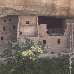
This place is so beautiful and peaceful. It's hard to imagine how hard it must have been to live…read moreback then. Take the hikes if you can. Get tickets at the main office to hike down to the dwellings. They will only let so many people down a day.
Photos
Vermillion Cliffs National Monument
Vermillion Cliffs National Monument - Paria Canyon-a bit muddy and sloppy

See all

Paria Canyon-a bit muddy and sloppy

Virgin River Trail - Virgin River North Trail

Virgin River Trail

4.6(12 reviews)
0.4 mi

I had an idyllic escape to St. George, UT during my spring break staycation back in March. After…read morearriving in St. George, I beelined to Confluence Park to bike the Virgin River Trail, which parallels the Virgin River for nearly 12 miles. The trail is well-maintained, extremely scenic, passes through diverse Southwestern landscapes, and is relatively flat (with the exception of the detour I took through picturesque Cottonwood Canyon on the Hell Hole Trail). Biking the Virgin River North Trail out and back from Confluence Park is roughly 18.2 miles. I did an extra seven miles on the Hell Hole & Virgin River South Trails to get me closer to 25 miles total. During my bike ride, I encountered photographers, runners, hikers, other bicyclists, and families/groups of people out on leisurely strolls. I would rate the Virgin River Trail as easy and suitable for all fitness levels. I found Cottonwood Canyon and the steep Hell Hole Trail hard/difficult as a novice biker, but well worth the effort! After my bike ride and lunch in St. George, the adventure continued with a scenic drive back home through the Virgin River Gorge (AZ), Moapa Valley (NV), and Lake Mead National Recreation Area (NV).

Sometimes we aren't in the mood for a true "hike" where you have to navigate trails, climb an…read moreincline or commit to a strenuous activity. There are times when we prefer a leisurely stroll, likely at the end of a dog leash, and the Virgin River Trail is just perfect for that! There's ample parking and restrooms at the park, then you can hop on the trail in a variety of directions. The path is paved and very clearly marked, so you know where to go. There are even signs along the way directing to different trails as well as information about the length. I especially like the bridges over the Virgin River-they make for a nice photo. Not a lot of shade, so if you're walking in the summer months, prepare for that.

Photos
Virgin River Trail - Cottonwood Canyon/Hell Hole Trail

Cottonwood Canyon/Hell Hole Trail

Virgin River Trail - Cottonwood Canyon/Hell Hole Trail

Cottonwood Canyon/Hell Hole Trail

Virgin River Trail - Virgin River North Trail

See all

Virgin River North Trail

Vermilion Cliffs National Monument - hiking - Updated October 2026

Loading...
Loading...
Loading...