Red Cliffs Desert Reserve Photos


More like Red Cliffs Desert Reserve
Recommended Reviews - Red Cliffs Desert Reserve
Start your review...

Reviews With Photos

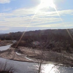
About twenty years ago, I went with a group of friends from high school hiking through this reserve. For years, I had fond memories of it and how beautiful it was. Then, this year, I had the opportunity to return and see it again with my family. Not much had changed, of course, except that the water that I'd remembered was dried up. But it looks like it may have seen water earlier in the year. Go in the spring if you want to see the pools fill up. There are a few trails-mostly marked, although there are some areas where it can be easy to wander off the marked trail. There are cool rock formations that invite you to climb on them. Be careful-some of that sandstone can get slick. Be sure to bring some water with you-the sun can beat down pretty hard, especially in the afternoon. Also, if you're visiting on a weekend or holiday, come early. The parking area fills up quickly. And bring $5 in cash to pay the entrance fee via envelope. There's no attendant, so it's on your honor. I wouldn't chance it, if you're feeling like being a jerk. I saw some government trucks driving around.

I recommend downloading the All Trails app to get familiar with the trails, which is where I heard about Gecko Trail. We started on the Gecko trail, it is an in-and-out trail located behind a neighborhood so no parking fee and little to no crowds. Trail was easy for our kids and it was a perfect day to go outside. Temperature mid 50s at the end March. Popular area for mountain bikers too. Red Cliffs Desert Reserve is not to be missed during your visit!

I had a lot of fun. We came pretty early. Hit a few trails. I am coming from Washington and it's a completely different experience. The one thing that is the same is the crowds. Just pretty busy like all hikes. It was beautiful for sure. The dinosaur stuff was pretty cool. The sites were lovely. I would love to spend a few days camping here. Drink all night hike all day.
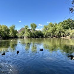
Yelp seems to not want to listen that the address to this location is the Visitor Center. It's 15-20 minutes away from the actual park and campground. I have sent them this detail 3 times, and they keep defaulting to addresses in the middle of the city. That being said, there is a hiking area and campground 15-20 minutes north off I-15. I posted a picture and URL of the map to the entry. There are newly paved single lane roads into the camp with overnight and day use parking. This is a fee use area and not free. I went hiking at this location based on the reviews and pictures with running water. This location is desolate and there was no running water, if there is ever running water its likely only spring or fall. There is very little maintenance of the trails, markers, or view areas. You are really on your own and good luck. I would not return to this location to go hiking and would prefer Mt Charleston or Red Rock which seem to be much better maintained in the least they are closer and more suitable for hiking on a day trip.

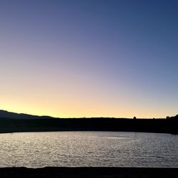
Love, love, LOVE this place!!!! We did a quick stop on the way from St. George to LA, and honestly, it's about as good of a nature getaway as you can get off of i15. Only $5 to enter, and there are pretty picnic areas and beautiful red rock you can take in at a fairly easy and quick pace, without having to take a huge dip into your drive time. Highly recommend -- we will be back to try other trails.

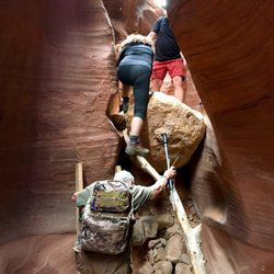
Came into the park just off Washington Parkway & I-15. Good sized parking lot that on weekends is always full to bursting. Trail starts out on a access road as you head north. We continued about 3/4 of a mile and spit off to the west towards a rocky ridge. We found a trail that ran to the south that was moving in and out of the small canyons. We saw a few other hikers and even encountered a horse back rider. Exposed with no shade so bring water for everyone. Along the trail we saw a few signs that told us of Dino tracks. As we kept going we weren't sure where they were. As we came to the bottom of a dry river wash we headed up to the side and that's were we found the tracks. They are great and easy to see. Sand obscures them, but a small broom/brush left by someone helped so we took some pics. To make it back to the car we walked down a service road from a water tower to main paved road. Then about 3/4 a mile to car parking. So many trails you could spend lots of romaine here exploring. Saw hawks, ravens and lots of lizards. Alas no desert tortoise!

Super fun and easy family hike! it was only $5 to park ($15 if you camp)! This whole area was just breathtakingly beautiful! I was worried it might be difficult to hike bc it's red cliffs but it was super easy and super fun for everyone! It rained a little while we were there but we were able to take cover under some of the rock. It was a pretty to see. I would definitely recommend hiking here!

This was a very pretty camp site. It was a smaller campground and seemed a little off the beaten path, which is kind of nice. It was close to the highway yet still quiet. I don't believe there were showers here, but the pretty red rocks make up for it. The camp site was very nice and included a covered patio and picnic table which was crucial due to the thunderstorm that passed through. Even in the pouring rain, we were able to cook and eat our dinner thanks to the covered area. Our camp site was $15, pay via envelope, and it was a quick drive to Zion the following morning.

Nice park full of red rocks. Lots of hiking trails to choose from that vary in difficulty. It's a dog friendly park also. But for a black cockapoo there isn't much shade while hiking and it was close to 90" on the day we were there. Didn't realize how large an area the park encompassed until I actually looked at a map of the area. Evidently a good place to look for desert tortoises too. Morris and I decided that on our next visit here we are going to look for Gila Monsters.

What a fun little area we found and got to explore. Stunning vistas of St. George too. There are a few parking lots, and they are free too. There is a place to eat with several picnic tables too. There are some informational signs explaining the history of the area. The landscape is red / orange and full of places to explore and hike around. There are some neat little caves, arches, and assorted nooks and crannies. Great place for everyone to enjoy. I saw families with little ones climbing and hiking, and adults of various ages traversing the rocks. There is a way to hike up to the top of the largest peak, but it is slippery getting up and down. There were some people practicing repelling down from the top. Enjoy the photos. read more


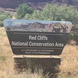
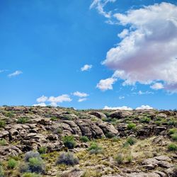
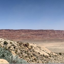
Well Red Gigantic ±45k-acre conservation area that was established in 1996 and features almost 130-miles of hiking trails. We only explored a very small portion of the area as we needed to mosey on over to our final destination of Zion but it def looks like something we'd be all-over if we're in the area again. The views are spectacular but be sure to bring water, hat and sunscreen as there's not much in the way of shade--at least in the St George portion we reconnoitered. Happy hikes, kids! read more


1 year ago
About twenty years ago, I went with a group of friends from high school hiking through this reserve. For years, I had fond memories of it and how beautiful it was. Then, this year, I had the opportunity to return and see it again with my family. Not much had changed, of course, except that the water that I'd remembered was dried up. But it looks like it may have seen water earlier in the year. Go in the spring if you want to see the pools fill up. There are a few trails-mostly marked, although there are some areas where it can be easy to wander off the marked trail. There are cool rock formations that invite you to climb on them. Be careful-some of that sandstone can get slick. Be sure to bring some water with you-the sun can beat down pretty hard, especially in the afternoon. Also, if you're visiting on a weekend or holiday, come early. The parking area fills up quickly. And bring $5 in cash to pay the entrance fee via envelope. There's no attendant, so it's on your honor. I wouldn't chance it, if you're feeling like being a jerk. I saw some government trucks driving around. read more


I recommend downloading the All Trails app to get familiar with the trails, which is where I heard about Gecko Trail. We started on the Gecko trail, it is an in-and-out trail located behind a neighborhood so no parking fee and little to no crowds. Trail was easy for our kids and it was a perfect day to go outside. Temperature mid 50s at the end March. Popular area for mountain bikers too. Red Cliffs Desert Reserve is not to be missed during your visit! read more

I had a lot of fun. We came pretty early. Hit a few trails. I am coming from Washington and it's a completely different experience. The one thing that is the same is the crowds. Just pretty busy like all hikes. It was beautiful for sure. The dinosaur stuff was pretty cool. The sites were lovely. I would love to spend a few days camping here. Drink all night hike all day. read more


7 years ago
Yelp seems to not want to listen that the address to this location is the Visitor Center. It's 15-20 minutes away from the actual park and campground. I have sent them this detail 3 times, and they keep defaulting to addresses in the middle of the city. That being said, there is a hiking area and campground 15-20 minutes north off I-15. I posted a picture and URL of the map to the entry. There are newly paved single lane roads into the camp with overnight and day use parking. This is a fee use area and not free. I went hiking at this location based on the reviews and pictures with running water. This location is desolate and there was no running water, if there is ever running water its likely only spring or fall. There is very little maintenance of the trails, markers, or view areas. You are really on your own and good luck. I would not return to this location to go hiking and would prefer Mt Charleston or Red Rock which seem to be much better maintained in the least they are closer and more suitable for hiking on a day trip. read more


Love, love, LOVE this place!!!! We did a quick stop on the way from St. George to LA, and honestly, it's about as good of a nature getaway as you can get off of i15. Only $5 to enter, and there are pretty picnic areas and beautiful red rock you can take in at a fairly easy and quick pace, without having to take a huge dip into your drive time. Highly recommend -- we will be back to try other trails. read more


Came into the park just off Washington Parkway & I-15. Good sized parking lot that on weekends is always full to bursting. Trail starts out on a access road as you head north. We continued about 3/4 of a mile and spit off to the west towards a rocky ridge. We found a trail that ran to the south that was moving in and out of the small canyons. We saw a few other hikers and even encountered a horse back rider. Exposed with no shade so bring water for everyone. Along the trail we saw a few signs that told us of Dino tracks. As we kept going we weren't sure where they were. As we came to the bottom of a dry river wash we headed up to the side and that's were we found the tracks. They are great and easy to see. Sand obscures them, but a small broom/brush left by someone helped so we took some pics. To make it back to the car we walked down a service road from a water tower to main paved road. Then about 3/4 a mile to car parking. So many trails you could spend lots of romaine here exploring. Saw hawks, ravens and lots of lizards. Alas no desert tortoise! read more


Super fun and easy family hike! it was only $5 to park ($15 if you camp)! This whole area was just breathtakingly beautiful! I was worried it might be difficult to hike bc it's red cliffs but it was super easy and super fun for everyone! It rained a little while we were there but we were able to take cover under some of the rock. It was a pretty to see. I would definitely recommend hiking here! read more


This was a very pretty camp site. It was a smaller campground and seemed a little off the beaten path, which is kind of nice. It was close to the highway yet still quiet. I don't believe there were showers here, but the pretty red rocks make up for it. The camp site was very nice and included a covered patio and picnic table which was crucial due to the thunderstorm that passed through. Even in the pouring rain, we were able to cook and eat our dinner thanks to the covered area. Our camp site was $15, pay via envelope, and it was a quick drive to Zion the following morning. read more

9 years ago
Nice park full of red rocks. Lots of hiking trails to choose from that vary in difficulty. It's a dog friendly park also. But for a black cockapoo there isn't much shade while hiking and it was close to 90" on the day we were there. Didn't realize how large an area the park encompassed until I actually looked at a map of the area. Evidently a good place to look for desert tortoises too. Morris and I decided that on our next visit here we are going to look for Gila Monsters. read more


6 years ago
7 years ago
8 years ago
11 years ago
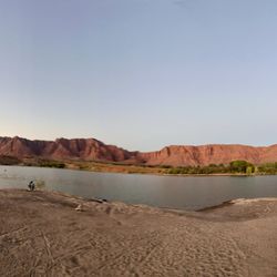
Great southwest scenery with red rocks galore!. Located mostly north of St. George UT. The reserve has numerous hiking areas, a recreation area and the Virgin River running through its eastern part. Dinosaur tracks and petrified dunes can also be found. Great place to spend the day. read more


10 years ago
More info about Red Cliffs Desert Reserve
180 N 200 E
Ste 111
St. George, UT 84770
Directions
Visit Website
http://www.redcliffsdesertreserve.com
Hours
Outdoor Amenities
Other Amenities
Red Cliffs Desert Reserve Reviews in Other Languages
Ask the Community - Red Cliffs Desert Reserve
Review Highlights - Red Cliffs Desert Reserve


Red Cliffs Desert Reserve - hiking - Updated June 2026
Best of St. George
People found Red Cliffs Desert Reserve by searching for…
Nice Places to Take Pictures in St. George, Utah
Hiking Trails With Waterfalls in St. George, Utah
Free Things to Do in St. George, Utah
Things to Do With Kids in St. George, Utah
Fun Things to Do at Night in St. George, Utah
Off Road Trails in St. George, Utah
Jeep Rental in St. George, Utah
Secret Spots in St. George, Utah
Scenic Drive in St. George, Utah
View Points in St. George, Utah
Dinosaur Park in St. George, Utah
River Swimming in St. George, Utah
Walking Trails in St. George, Utah
Natural Hot Springs in St. George, Utah
Night Hike in St. George, Utah
Free Campgrounds in St. George, Utah
Off Leash Dog Parks in St. George, Utah
River Tubing in St. George, Utah
Night Walk in St. George, Utah
Nature Center in St. George, Utah
Trending Searches in St. George, UT
Boat Rental near Red Cliffs Desert Reserve
Cabins near Red Cliffs Desert Reserve
Cliff Jumping near Red Cliffs Desert Reserve
Day Trips near Red Cliffs Desert Reserve
Dog Friendly Beaches near Red Cliffs Desert Reserve
Dog Friendly Trails near Red Cliffs Desert Reserve
Fireworks near Red Cliffs Desert Reserve
Fishing Spots near Red Cliffs Desert Reserve
Jet Ski Rental near Red Cliffs Desert Reserve
Kayak Rental near Red Cliffs Desert Reserve
Lakes near Red Cliffs Desert Reserve
Long Term Rv Parking near Red Cliffs Desert Reserve
Outdoor Activities near Red Cliffs Desert Reserve
Picnic Spots near Red Cliffs Desert Reserve
Pool Day Pass near Red Cliffs Desert Reserve
Public Pools near Red Cliffs Desert Reserve
Public Shower near Red Cliffs Desert Reserve
River Swimming near Red Cliffs Desert Reserve
River Tubing near Red Cliffs Desert Reserve
Rv Campgrounds near Red Cliffs Desert Reserve
Scenic Night View near Red Cliffs Desert Reserve
Scenic Overlook near Red Cliffs Desert Reserve
Splash Pad near Red Cliffs Desert Reserve
Sunrise View near Red Cliffs Desert Reserve
Swimming Holes near Red Cliffs Desert Reserve
Swimming Lakes near Red Cliffs Desert Reserve
Watch Sunset near Red Cliffs Desert Reserve
Browse Articles
Browse Nearby
BEST of St. George, Utah Things to Do near Red Cliffs Desert Reserve
BEST of St. George, Utah Restaurants near Red Cliffs Desert Reserve
BEST of St. George, Utah Coffee near Red Cliffs Desert Reserve
BEST of St. George, Utah Hot Springs near Red Cliffs Desert Reserve
BEST of St. George, Utah Walking Trails near Red Cliffs Desert Reserve
BEST of St. George, Utah Parks near Red Cliffs Desert Reserve
BEST of St. George, Utah Breakfast near Red Cliffs Desert Reserve
BEST of St. George, Utah Campgrounds near Red Cliffs Desert Reserve
BEST of St. George, Utah Sightseeing near Red Cliffs Desert Reserve
Browse Brands
Related Cost Guides
Related Searches in St. George, UT
Affordable Kayak Rental Services in St. George, Utah
Affordable Long Term RV Parking in St. George, Utah
Affordable RV Rental Options in St. George, Utah
Best Fishing Locations and Guides in St. George, Utah
Best Off Leash Dog Parks in St. George, Utah
Best Places for Horseback Riding in St. George, Utah
Best Water Parks for Kids in St. George, Utah
Browse Charming Cabins in St. George, Utah
Browse Top Hotels in St. George, Utah for Your Stay
Browse Vacation Rentals to Book in St. George, Utah
Check Out Great Playgrounds in St. George, Utah
Check Out Off Road Trails in St. George, Utah
Discover Beautiful Garden Spots in St. George, Utah
Discover Dog Friendly Trails to Explore in St. George, Utah
Discover Free Campgrounds in St. George, Utah Area
Discover Fun Activities to Do in St. George, Utah
Discover Kid Friendly Hiking Trails in St. George, Utah
Discover Popular Photo Spots in St. George, Utah
Discover Top Nature Parks to Visit in St. George, Utah
Discover a Hiking Trail in St. George, Utah
Discover the Best Beaches in St. George, Utah
Discover the Best Kids Park Spots in St. George, Utah
Discover the Best Night Hike Trails in St. George, Utah
Enjoy Camping Adventures Around St. George, Utah
Enjoy Exciting Mountain Biking Adventures in St. George, Utah
Enjoy Hiking Adventures in St. George, Utah
Enjoy Kayaking Adventures in St. George, Utah
Enjoy Tent Camping Spots Around St. George, Utah
Enjoy a Relaxing Bed & Breakfast Experience in St. George, Utah
Enjoy the Best Family Activities in St. George, Utah
Enjoy the Best Picnic Spots and Ideas in St. George, Utah
Enjoy the Best Walking Trails in St. George, Utah
Experience the Best Family Fun in St. George, Utah for All
Explore Beautiful Parks and Green Spaces in St. George, Utah
Explore Bike Rentals Throughout St. George, Utah
Explore Easy Hikes Perfect for All in St. George, Utah
Explore Free Picnic Areas Around St. George, Utah
Explore Fun Activities to Do in St. George, Utah
Explore Hotels & Travel Options in St. George, Utah
Explore Popular Campgrounds Near St. George, Utah
Explore Popular Picnic Areas Around St. George, Utah
Explore Popular RV Parks Around St. George, Utah
Explore Popular Recreation Centers Around St. George, Utah
Explore Scenic Lakes to Visit in St. George, Utah
Explore Secret Spots Worth Visiting in St. George, Utah
Explore Summer Camps for All Ages in St. George, Utah
Explore Top Dog Parks in St. George, Utah Near You
Explore Top Gyms in St. George, Utah Now
People who viewed Red Cliffs Desert Reserve also viewed
Gunlock Falls
11 reviews
Sand Hollow State Park
147 reviews
Quail Creek State Park
42 reviews
Virgin River Trail
12 reviews
Anasazi Valley Trail
10 reviews
Vermillion Cliffs National Monument
6 reviews
Crosby Confluence Park
2 reviews
Pine Valley Recreation Area
7 reviews
Bloomington Petroglyph Park
18 reviews
Fire Lake Park at Ivins Reservoir
7 reviews