Tramonto Trailhead Overlook Photos


You might also consider
More like Tramonto Trailhead Overlook
Recommended Reviews - Tramonto Trailhead Overlook
Start your review...

3 months ago
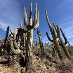
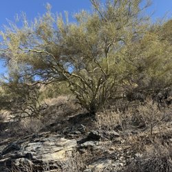
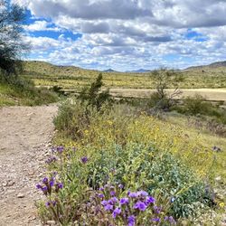
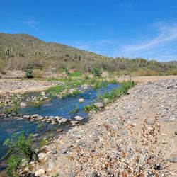
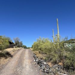
I believe there are a couple of trail options to get to the overlook. We took the trail right off of 17. There was a gravel area to park (only a few spots available) at the base. The trail is a bit steep with a good amount of loose rock. I recommend hiking shoes. It was a workout to get to the top but it doesn't take long, less than 30 minutes. There is a bit of road noise but the overlook is beautiful. read more


Location: Trail begins off the intersection of W Pioneer Road & N Gavilan Peak Parkway Parking: Free off of N Gavilan Peak Parkway Trail difficulty: Moderate consisting of rocks and dirt. I recommend hiking poles for stability :) Length: 0.9 of a mile Ambiance: Lightly trafficked with highway noise in the background. read more

More info about Tramonto Trailhead Overlook
W Pioneer Rd
New River, AZ 85086
Directions
Hours
Outdoor Amenities
You might also consider


Tramonto Trailhead Overlook - hiking - Updated May 2026
Best of New River
People found Tramonto Trailhead Overlook by searching for…
Things to Do in New River, Arizona
Scenic View in New River, Arizona
Off Road Trails in New River, Arizona
Hiking Trails in New River, Arizona
Lookout Points in New River, Arizona
Scenic Overlook in New River, Arizona
Running Trails in New River, Arizona
Places to Walk in New River, Arizona
Walking Trails in New River, Arizona
Sunrise Hike in New River, Arizona
Night Hiking in New River, Arizona
Free Parking in New River, Arizona
Photo Spots in New River, Arizona
What to Do in New River, Arizona
Off Leash Dog Hikes in New River, Arizona
Waterfalls and Swimming Holes in New River, Arizona
Stuff to Do in New River, Arizona
Beautiful Views in New River, Arizona
Jogging Trails in New River, Arizona
Waterfalls in New River, Arizona
Trending Searches in New River, AZ
Boat Rental near Tramonto Trailhead Overlook
Botanical Gardens near Tramonto Trailhead Overlook
Bounce House Rentals near Tramonto Trailhead Overlook
Campgrounds near Tramonto Trailhead Overlook
Cheap Plants near Tramonto Trailhead Overlook
Cherry Picking near Tramonto Trailhead Overlook
Cliff Jumping near Tramonto Trailhead Overlook
Flower Fields near Tramonto Trailhead Overlook
Flower Shop near Tramonto Trailhead Overlook
Garage Sales near Tramonto Trailhead Overlook
Garden Center near Tramonto Trailhead Overlook
Lakes & Ponds near Tramonto Trailhead Overlook
Nurseries & Gardening near Tramonto Trailhead Overlook
Outdoor Activities near Tramonto Trailhead Overlook
Outdoor Furniture Stores near Tramonto Trailhead Overlook
Parks near Tramonto Trailhead Overlook
Party Equipment Rentals near Tramonto Trailhead Overlook
Pedicure near Tramonto Trailhead Overlook
Photo Spots near Tramonto Trailhead Overlook
Picnic Areas near Tramonto Trailhead Overlook
Places To Take Pictures near Tramonto Trailhead Overlook
Rock Quarry near Tramonto Trailhead Overlook
Running Trails near Tramonto Trailhead Overlook
Rv Rental near Tramonto Trailhead Overlook
Scenic Drive near Tramonto Trailhead Overlook
Sunrise View near Tramonto Trailhead Overlook
Swimming Holes near Tramonto Trailhead Overlook
Table And Chair Rentals near Tramonto Trailhead Overlook
Browse Articles
Browse Nearby
BEST of New River, Arizona Restaurants near Tramonto Trailhead Overlook
BEST of New River, Arizona Coffee near Tramonto Trailhead Overlook
BEST of New River, Arizona Things to Do near Tramonto Trailhead Overlook
BEST of New River, Arizona Breakfast near Tramonto Trailhead Overlook
BEST of New River, Arizona Parks near Tramonto Trailhead Overlook
BEST of New River, Arizona Horseback Riding near Tramonto Trailhead Overlook
BEST of New River, Arizona Campgrounds near Tramonto Trailhead Overlook
BEST of New River, Arizona Hotels near Tramonto Trailhead Overlook
Browse Brands
Related Searches in New River, AZ
Affordable Kayak Rental Services in New River, Arizona
Best Fishing Locations and Guides in New River, Arizona
Best Places for Horseback Riding in New River, Arizona
Best Waterfalls and Swimming Holes in New River, Arizona
Check Out Off Road Trails in New River, Arizona
Discover Dog Friendly Trails to Explore in New River, Arizona
Discover Kid Friendly Hiking Trails in New River, Arizona
Discover Scenic Mountain Bike Trails Near New River, Arizona
Discover Scenic Walking Paths in New River, Arizona
Discover Scenic Waterfall Spots in New River, Arizona
Discover Top Scenic Spots to Visit in New River, Arizona
Discover a Hiking Trail in New River, Arizona
Discover the Best Night Hike Trails in New River, Arizona
Enjoy Exciting Mountain Biking Adventures in New River, Arizona
Enjoy Kayaking Adventures in New River, Arizona
Enjoy River Tubing Adventures in New River, Arizona
Enjoy Tent Camping Spots Around New River, Arizona
Enjoy a Beautiful Waterfall Hike in New River, Arizona
Enjoy a Scenic Walk in New River, Arizona
Enjoy the Best Walking Trails in New River, Arizona
Exciting Cliff Jumping Spots in New River, Arizona
Experience Thrilling White Water Rafting in New River, Arizona
Explore Beautiful Parks and Green Spaces in New River, Arizona
Explore Easy Hikes Perfect for All in New River, Arizona
Explore Fun Activities to Do in New River, Arizona
Explore Popular Campgrounds Near New River, Arizona
Explore Popular Scenic Overlook Points in New River, Arizona
Explore Scenic Lakes to Visit in New River, Arizona
Explore the Best Beach Spots in New River, Arizona
Explore the Best Boating Spots in New River, Arizona
Explore the Best Trail Options in New River, Arizona
Find Beautiful Views in New River, Arizona
Find Cozy Camping Cabins in New River, Arizona
Find Popular Ziplining Spots Around New River, Arizona
Find the Best Parks for Picnics in New River, Arizona
Find the Best Scenic View Locations in New River, Arizona
Hiking Trails With Waterfalls in New River, Arizona
Off Leash Dog Hiking Trails in New River, Arizona
Plan a Scenic Drive Route Near New River, Arizona
Popular Fishing Spots to Explore in New River, Arizona
Popular Outdoor Activities to Try in New River, Arizona
Popular Picnic Spots to Visit in New River, Arizona
Safe River Swimming Areas in New River, Arizona
Safe and Fun Parks for Kids in New River, Arizona
Top Climbing Spots and Gyms in New River, Arizona
Top Paddleboarding Activities in New River, Arizona
Top Running Trails to Explore in New River, Arizona
Top Swimming Lakes to Enjoy in New River, Arizona
People who viewed Tramonto Trailhead Overlook also viewed
Rose Garden Mountain
2 reviews
Desert Hills Trailhead
4 reviews
Desert Vista Trail Head
9 reviews
Sonoran Preserve
3 reviews
Daisy Mountain Trailhead
5 reviews
West Wing Mountain Trail
11 reviews
Black Canyon City Trailhead
1 review
Spur Cross Ranch Conservation Area
4 reviews
Cave Creek Trail
3 reviews
New River Trailhead at Fletcher Heights
1 review