Tiogue Lake Photos


You might also consider
More like Tiogue Lake
Recommended Reviews - Tiogue Lake
Start your review...

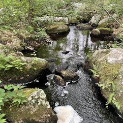
2 years ago
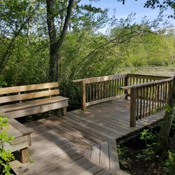
3.5! A pretty little spot on Arnold Road. I have seen people fishing here and enjoying picnics. There is a gentleman here that gives free fishing lessons and provides all the equipment. New boat access and I wouldn't be swimming in this water read more


More info about Tiogue Lake
Arnald Rd
Coventry, RI 02816
Directions
Hours
Outdoor Amenities
You might also consider


Why does Yelp recommend reviews?
1 review that is not currently recommended
The reviews below are not factored into the business's overall star rating.
14 years ago
Tiogue Lake - lakes - Updated May 2026
Best of Coventry
People found Tiogue Lake by searching for…
Swimming Lakes in Coventry, Rhode Island
Swimming Holes in Coventry, Rhode Island
Fishing Spots in Coventry, Rhode Island
Fishing in Coventry, Rhode Island
Things to Do in Coventry, Rhode Island
Lakes & Ponds in Coventry, Rhode Island
Places to Swim in Coventry, Rhode Island
Fishing Lake in Coventry, Rhode Island
Boating in Coventry, Rhode Island
Picnic Areas in Coventry, Rhode Island
Swimming in Coventry, Rhode Island
Picnic Spots in Coventry, Rhode Island
Scenic Views in Coventry, Rhode Island
Places to Take Pictures in Coventry, Rhode Island
Watch Sunset in Coventry, Rhode Island
Romantic Views in Coventry, Rhode Island
Walking Trails in Coventry, Rhode Island
Cruising Spots in Coventry, Rhode Island
Fishing Ponds in Coventry, Rhode Island
Feed Ducks in Coventry, Rhode Island
Hiking Trails With Waterfalls in Coventry, Rhode Island
Things to See in Coventry, Rhode Island
Trending Searches in Coventry, RI
Botanical Gardens near Tiogue Lake
Bounce House Rentals near Tiogue Lake
Camping Sites near Tiogue Lake
Dog Friendly Trails near Tiogue Lake
Floral Designers near Tiogue Lake
Free Picnic Areas near Tiogue Lake
Garden Center near Tiogue Lake
Lakes & Ponds near Tiogue Lake
Nurseries & Gardening near Tiogue Lake
Outdoor Basketball Courts near Tiogue Lake
Outdoor Furniture Stores near Tiogue Lake
Parks With Pull Up Bars near Tiogue Lake
Party Equipment Rentals near Tiogue Lake
Places To Take Pictures near Tiogue Lake
Plant Nursery near Tiogue Lake
River Swimming near Tiogue Lake
Running Trails near Tiogue Lake
Scenic Restaurants near Tiogue Lake
Browse Articles
Browse Nearby
BEST of Coventry, Rhode Island Coffee near Tiogue Lake
BEST of Coventry, Rhode Island Restaurants near Tiogue Lake
BEST of Coventry, Rhode Island Things to Do near Tiogue Lake
BEST of Coventry, Rhode Island Fishing Spots near Tiogue Lake
BEST of Coventry, Rhode Island Campgrounds near Tiogue Lake
BEST of Coventry, Rhode Island Swimming Holes near Tiogue Lake
BEST of Coventry, Rhode Island Breakfast near Tiogue Lake
Browse Brands
Related Searches in Coventry, RI
Affordable Kayak Rental Services in Coventry, Rhode Island
Best Fishing Locations and Guides in Coventry, Rhode Island
Best Places for Stunning Views in Coventry, Rhode Island
Discover Lakes & Ponds to Explore in Coventry, Rhode Island
Discover Public Beaches to Visit in Coventry, Rhode Island
Discover Scenic Beach Camping Sites in Coventry, Rhode Island
Discover Top Boat Tours in Coventry, Rhode Island for All Ages
Discover the Best Beaches in Coventry, Rhode Island
Discover the Best Fishing Lake in Coventry, Rhode Island
Enjoy Kayaking Adventures in Coventry, Rhode Island
Enjoy Tent Camping Spots Around Coventry, Rhode Island
Enjoy Water Activities and Fun in Coventry, Rhode Island
Enjoy the Best Walking Trails in Coventry, Rhode Island
Exciting Cliff Jumping Spots in Coventry, Rhode Island
Explore Beautiful Parks and Green Spaces in Coventry, Rhode Island
Explore Easy Hikes Perfect for All in Coventry, Rhode Island
Explore Popular Campgrounds Near Coventry, Rhode Island
Explore Popular Picnic Areas Around Coventry, Rhode Island
Explore Popular Scenic Views Near Coventry, Rhode Island
Explore Secluded Beaches to Relax in Coventry, Rhode Island
Explore Secret Spots Worth Visiting in Coventry, Rhode Island
Explore Top Dog Parks in Coventry, Rhode Island Near You
Explore Top Marinas Near Coventry, Rhode Island
Explore Top Water Parks in Coventry, Rhode Island Today
Explore the Best Swimming Holes Around Coventry, Rhode Island
Explore the Scenic River in Coventry, Rhode Island
Find Beautiful Views in Coventry, Rhode Island
Find Parks and Recreation Activities in Coventry, Rhode Island
Find Picnic Tables for Outdoor Fun in Coventry, Rhode Island
Find Top Dog Friendly Parks to Visit in Coventry, Rhode Island
Find Top Dog Swimming Spots in Coventry, Rhode Island
Find Top-Rated Waterfalls in Coventry, Rhode Island Now
Find the Best Parks for Picnics in Coventry, Rhode Island
Find the Best Playgrounds to Visit in Coventry, Rhode Island
Find the Best Swimming Pools in Coventry, Rhode Island Today
Great Places to Swim in Coventry, Rhode Island
Have Fun at a Splash Pad in Coventry, Rhode Island
Hiking Trails With Waterfalls in Coventry, Rhode Island
Popular Fishing Spots to Explore in Coventry, Rhode Island
Popular Outdoor Activities to Try in Coventry, Rhode Island
Safe River Swimming Areas in Coventry, Rhode Island
Safe and Fun Parks for Kids in Coventry, Rhode Island
Top Hiking Trails to Explore in Coventry, Rhode Island
Top Playgrounds for Kids to Enjoy in Coventry, Rhode Island
Top Running Trails to Explore in Coventry, Rhode Island
Top Swimming Lakes to Enjoy in Coventry, Rhode Island
Top Swimming Spots and Pools in Coventry, Rhode Island
Top-Rated Hikes in Coventry, Rhode Island to Explore
People who viewed Tiogue Lake also viewed
Conimicut Point Park
24 reviews
Arcadia Beach Pond
2 reviews
Rocky Point Walking Path
36 reviews
Georgiaville Pond Beach
11 reviews
Frenchtown Park Trail
13 reviews
Rocky Point State Park
27 reviews
Wakefield Pond
1 review
Canada Pond
1 review
Charles
Yawgoo Valley Ski Area & Water Park
64 reviews
Warwick City Park
39 reviews