Tettegouche State Park Photos


More like Tettegouche State Park
Recommended Reviews - Tettegouche State Park
Start your review...

Reviews With Photos

A beautiful MN state park! It is easy to get to, right off of Hwy 61 with a decent size parking lot (though not huge, I can imagine it filling up on a nice summer weekend). Visitor Center is very nice, with clean bathrooms, tables, a fireplace, store, and even a coffee shop! We went on the Shovel Point trail (starting at the visitor center), the High Falls/Two Step Falls (from our campground) trail, and the Bean/Bear Lake trail (which technically starts outside the park border). The trails inside the park were well-groomed and maintained. To get to the waterfalls, there are a decent amount of stairs to get down (and back up!). The Baptism River Campground was nice, with very private sites. From this campground, you also have a really short trail to the waterfalls. Beautiful views within the park, especially in the fall! Pro tip: if you are a disabled veteran, bring a copy of your VA letter to get a free MN state park pass!!

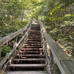
The visitors center is fantastic with a great rest area with well maintained restrooms. This was probably our third hike to Shovel Point. Our large family of all ages tried it the first time. It's a decent quick hike for almost every family to the top of Shovel Point for some awesome panoramic views and pictures. Just over 1 mile round trip but with at least 180 stairs. So, it's not an easy hike for those with bad knees or like today for my wife and I (sore legs after hiking the last few days at Grand Portage and the Canadian border).


Another great State Park. No fee if you hike from the Visitor's Center. I suggest a weekday because parking is tight. First we hiked the 3 miles round trip to the High Falls, beautiful and well worth it. Next we hiked to the Cascade Falls. The Late July water run was not enough to make it worth the 1.5 mile hike but the beauty of the hike makes it a go. The trail is rough and uneven in spots so caution is recommended. Last we hiked the Shovel Point trail, 1.5 miles. Just plain gorgeous with beautiful views of the lake and access to the beach. All three hikes offer great lunch spots. All three trails are well marked and used my many. You will not get lost. Have fun and hike!!!!!
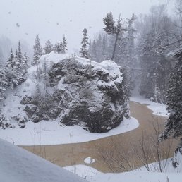
In the words of the musical maestro Jackie Wilson...WOOOOOOoooooo E! Arrived here by way of Split Rock lighthouse, just as the snow was tapering off (by tapering, I mean snowing regularly instead of near white out conditions). I expected the park to be amazing when I pulled up and saw the incredible newer structure (built in the past few years,) but once I started walking around, it exceeded ALL expectations! By the way, thanks to the perfect directions by the incredibly friendly staff I was directed to the magic that followed. Not surprisingly, (as the feckless country recently crested 40% obesity) I had the whole park to myself, and what a magical winter wonderland it was. It was a blessed day in every way (isn't that the case any time is spent outside in fresh air? I'm asking a leading question to shove it the readers face that this day was particularly fresh both of smell, sight and sound (which there was little of the latter the further I hiked, but much of the former, which I very much liked). So inspired was I, just now in my head, popped a soliloquy: Further I did go, then further again, oft through knee deep snow. Further I strode, far from the road, til I crested the hill, then down I rode Though most of the ice and snow had not melted, there was still a large amount of water running under, and occasionally through the ice. The contrast between the tannin colored river, and the thickly covered, freshly fallen snow, not to mention the snow still falling made it seem like thine self was the sole inhabitant of this snow globe. I ended up hanging out on that path for a few hours, then went back to the parking lot, and took the other trail in the opposite direction, (which was nearly as cool, but sullied at the top, when the peace and quiet was broken like shattered glass when some millenial hens were clucking much too loud, seemingly endlessly, possibly virtue signaling). I give them credit for making the slippery trek tho.

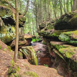
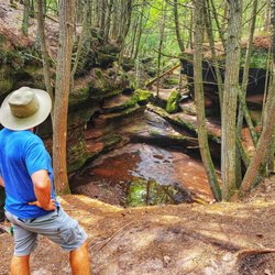
This is a really cool state park and one that's good for groups, kids, etc. because there is a huge reward (waterfall!) with very little effort needed. Unlike some state parks where you need to do a longer, more rigorous hike to get to the awesome view, this one presents an amazing natural feature within a very short hike from the Visitor's Center. No wonder it's so popular! The waterfall is of course gorgeous, and I love that you can climb up and down to see various angles and portions of the waterfall. I would note that there are portions where you can walk right up to the edge of the waterfall with no guardrails or boundaries, so little kids, pets, etc., would need to be watched closely. While we were there, there were a bunch of kids running around at full tilt, and I was sure one of them was going to fall and get seriously injured. But it really is a beautiful place and totally worth a pit stop if you are driving by!


What a TOUGH but awesome hike! We jouneyed to the big falls from the parking lot at the center of the park. It was still a long walk but the park was so beautiful and peaceful as we wove through the pine groves and came upon the large cascade falls. We crossed a suspension bridge and down what felt like a thousand stairs to the base of the falls. A lot of people there so getting pictures of just the falls had its challenges. Then we journeyed to two step falls. Holy crap!! I like climbing hills but this was a definite workout! So many hills and stairs I lost count. It was a beautiful sight but not nearly as breathtaking as cascade falls was. If you want a hard workout, take the trek but if not, skip the trail to two step. They have a GREAT visitor center, large, modern and clean. Nice gift shop too. I picked up a tshirt and my first park passport stamp. Can't wait to return and explore more trails.

It was super gorgeous and relaxing - didn't expect Minnesota to have such tall water falls. The hike itself was a little hard when your foot falls through a foot of snow, but obviously I knew beforehand that there was gonna be snow. There are a bunch of maps and signs that tell you the distance before your next destination. Wasn't a long hike to the waterfall which was awesome, and I noticed a lot of trees with blue paint on the trails which was assuring you're going the right direction. For sure will come back in the summer!

We only had an hour or so and it was almost raining and so cold but this was still one of our favorite stops on the north shore! The hike to shovel point was gorgeous, the trails were so nice! and the short walk down to where the Baptism River meets Lake Superior was beautiful too. After, we stopped by the visitor's center (which is lovely) and got a pumpkin latte and hot apple cider. Perfect for the weather! Don't miss this place.

Beautiful hike to this waterfall! The waterfall itself is breath taking, there's space to swim, take pictures and bbq! Definitely a spot to go if you are able to do the hike! There are two trails one long and one medium the long one being 3 miles round trip and the medium length one being 1.5 miles round trip!

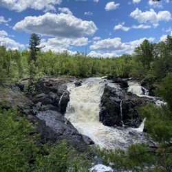
This is my favorite state park in Minnesota (of the 75). It's about 3-1/2 hours from the Twin Cities (northeast of Duluth). It has the most spectacular vistas and is a hiker's paradise. The cascading 60 foot High Falls waterfall into the Baptism River are beautiful, as are the view of Lake Superior. Palisade Head is not to be missed, either. The are ample bird watching opportunities in the park as well. read more


10 months ago
A beautiful MN state park! It is easy to get to, right off of Hwy 61 with a decent size parking lot (though not huge, I can imagine it filling up on a nice summer weekend). Visitor Center is very nice, with clean bathrooms, tables, a fireplace, store, and even a coffee shop! We went on the Shovel Point trail (starting at the visitor center), the High Falls/Two Step Falls (from our campground) trail, and the Bean/Bear Lake trail (which technically starts outside the park border). The trails inside the park were well-groomed and maintained. To get to the waterfalls, there are a decent amount of stairs to get down (and back up!). The Baptism River Campground was nice, with very private sites. From this campground, you also have a really short trail to the waterfalls. Beautiful views within the park, especially in the fall! Pro tip: if you are a disabled veteran, bring a copy of your VA letter to get a free MN state park pass!! read more


3 years ago
The visitors center is fantastic with a great rest area with well maintained restrooms. This was probably our third hike to Shovel Point. Our large family of all ages tried it the first time. It's a decent quick hike for almost every family to the top of Shovel Point for some awesome panoramic views and pictures. Just over 1 mile round trip but with at least 180 stairs. So, it's not an easy hike for those with bad knees or like today for my wife and I (sore legs after hiking the last few days at Grand Portage and the Canadian border). read more


Another great State Park. No fee if you hike from the Visitor's Center. I suggest a weekday because parking is tight. First we hiked the 3 miles round trip to the High Falls, beautiful and well worth it. Next we hiked to the Cascade Falls. The Late July water run was not enough to make it worth the 1.5 mile hike but the beauty of the hike makes it a go. The trail is rough and uneven in spots so caution is recommended. Last we hiked the Shovel Point trail, 1.5 miles. Just plain gorgeous with beautiful views of the lake and access to the beach. All three hikes offer great lunch spots. All three trails are well marked and used my many. You will not get lost. Have fun and hike!!!!! read more


In the words of the musical maestro Jackie Wilson...WOOOOOOoooooo E! Arrived here by way of Split Rock lighthouse, just as the snow was tapering off (by tapering, I mean snowing regularly instead of near white out conditions). I expected the park to be amazing when I pulled up and saw the incredible newer structure (built in the past few years,) but once I started walking around, it exceeded ALL expectations! By the way, thanks to the perfect directions by the incredibly friendly staff I was directed to the magic that followed. Not surprisingly, (as the feckless country recently crested 40% obesity) I had the whole park to myself, and what a magical winter wonderland it was. It was a blessed day in every way (isn't that the case any time is spent outside in fresh air? I'm asking a leading question to shove it the readers face that this day was particularly fresh both of smell, sight and sound (which there was little of the latter the further I hiked, but much of the former, which I very much liked). So inspired was I, just now in my head, popped a soliloquy: Further I did go, then further again, oft through knee deep snow. Further I strode, far from the road, til I crested the hill, then down I rode Though most of the ice and snow had not melted, there was still a large amount of water running under, and occasionally through the ice. The contrast between the tannin colored river, and the thickly covered, freshly fallen snow, not to mention the snow still falling made it seem like thine self was the sole inhabitant of this snow globe. I ended up hanging out on that path for a few hours, then went back to the parking lot, and took the other trail in the opposite direction, (which was nearly as cool, but sullied at the top, when the peace and quiet was broken like shattered glass when some millenial hens were clucking much too loud, seemingly endlessly, possibly virtue signaling). I give them credit for making the slippery trek tho. read more


This is a really cool state park and one that's good for groups, kids, etc. because there is a huge reward (waterfall!) with very little effort needed. Unlike some state parks where you need to do a longer, more rigorous hike to get to the awesome view, this one presents an amazing natural feature within a very short hike from the Visitor's Center. No wonder it's so popular! The waterfall is of course gorgeous, and I love that you can climb up and down to see various angles and portions of the waterfall. I would note that there are portions where you can walk right up to the edge of the waterfall with no guardrails or boundaries, so little kids, pets, etc., would need to be watched closely. While we were there, there were a bunch of kids running around at full tilt, and I was sure one of them was going to fall and get seriously injured. But it really is a beautiful place and totally worth a pit stop if you are driving by! read more

7 years ago

6 years ago
One of my favorite spots ever...excellent views and wonderful paths.. usually have helpful staff...unfortunately with Covid there is none.. read more


6 years ago

What a TOUGH but awesome hike! We jouneyed to the big falls from the parking lot at the center of the park. It was still a long walk but the park was so beautiful and peaceful as we wove through the pine groves and came upon the large cascade falls. We crossed a suspension bridge and down what felt like a thousand stairs to the base of the falls. A lot of people there so getting pictures of just the falls had its challenges. Then we journeyed to two step falls. Holy crap!! I like climbing hills but this was a definite workout! So many hills and stairs I lost count. It was a beautiful sight but not nearly as breathtaking as cascade falls was. If you want a hard workout, take the trek but if not, skip the trail to two step. They have a GREAT visitor center, large, modern and clean. Nice gift shop too. I picked up a tshirt and my first park passport stamp. Can't wait to return and explore more trails. read more


6 years ago
It was super gorgeous and relaxing - didn't expect Minnesota to have such tall water falls. The hike itself was a little hard when your foot falls through a foot of snow, but obviously I knew beforehand that there was gonna be snow. There are a bunch of maps and signs that tell you the distance before your next destination. Wasn't a long hike to the waterfall which was awesome, and I noticed a lot of trees with blue paint on the trails which was assuring you're going the right direction. For sure will come back in the summer! read more


7 years ago
We only had an hour or so and it was almost raining and so cold but this was still one of our favorite stops on the north shore! The hike to shovel point was gorgeous, the trails were so nice! and the short walk down to where the Baptism River meets Lake Superior was beautiful too. After, we stopped by the visitor's center (which is lovely) and got a pumpkin latte and hot apple cider. Perfect for the weather! Don't miss this place. read more


6 years ago
Beautiful hike to this waterfall! The waterfall itself is breath taking, there's space to swim, take pictures and bbq! Definitely a spot to go if you are able to do the hike! There are two trails one long and one medium the long one being 3 miles round trip and the medium length one being 1.5 miles round trip! read more

4 years ago
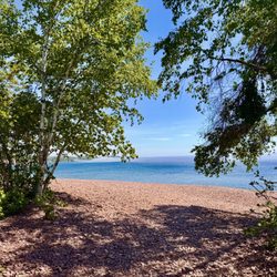
The is the crown jewel in the Minnesota State Park System, with something for every person and every season, very analogous to Cape Perpetua State Park on the Oregon Pacific Coast. The chief difference being: no tidepools in Minnesota. Shovel Point offers a short hike from the highway rest area. The trail juts out into Lake Superior. A 5 minute detour directly off of 61 takes you up a steep, winding (but not scary) road to the top of Palisade Head, with stunning views of Shovel Point and any ore freighter traffic far out on the lake. From the campground trails lead up to a series of potholes and waterfalls cascading through narrow gorges carved deep in solid rock. Pine trees line both sides of a trail that also bisects the famed Superior Hiking Trail. In addition to hiking, you can hunt for agates on the beach. The campground is gorgeous and also includes unique "cart-in" sites, a spin on walk-in sites where two-wheeled rickshaws are provided to get your stuff from your car to semi-secluded, beautiful tent sites nestled beneath tall pines According to the State Park Master Plan I studied as part of my undergraduate research in anthropology, the Tettegouche campground was the site of archaic and paleolithic stone-tool making peoples'. Paleo point arrow heads, signs of habitation, and stone age copper mines dating from 1,000-3,000 years BCE have been discovered here. For some reason, I've never seen this mentioned in the interpretive signage or literature at the park. This was a major tool-making site. Further inland, this park has a heart that few people see. There is a set of restored log cabins built by the CCC in the 1930's on Mic Mac Lake that come with a mini-fridge, wood-burning stove and electric range that are available for rent. Each cabin rental comes with a key to a canoe on tiny Mic Mac lake, available 24 hours per day. I have often taken the canoe out at dusk or later in the fall as mist rises from the water, listening to the sounds of loons calling and fish jumping. I'm just going to pause right here and say, "thank you FDR for the amazing social welfare programs you pioneered that are still adding to our enjoyment of this country almost 100 years later." The CCC cabins are at the center of an amazing trail system that rings the camp like a wagon wheel with multiple spokes. It will take you to beautiful bogs, a beaver dam, a remote, alpine-like lake, through pine forests, and through endless stands of maple and birch that pulse with light as they turn crimson, orange and yellow in the Fall. Challenging hikes to overviews of Lake Superior and the park's interior exist at every point of the compass. Raven Rock is my favorite. If you did nothing else but stayed in the cabins and went on day hikes in the interior of the park, it could still take you three full days to see everything within a day-hike's ramble of the CCC camp. The cabins are a 1.75 mile hike in from a remote parking lot, so stow your valuables carefully, and have a plan for getting your stuff to the cabin. The hike in is mostly uphill, and rather grueling. In winter, it's easy to pull a cheap plastic sled with your gear lashed to it. In Fall, I usually bring my bike, lash my gear to it and walk it in to camp, although you can ride it too. Note however, that except for the trail leading to the camp, all the surrounding trails do not allow bikes. Fall during peak fall colors (usually sometime between Sept 20th and Oct. 15th) is the best time to be here. As far as renting the cabins goes, if you don't reserve them nearly a year in advance, forget about it. This place is no secret. The campground is also impossible to get into without lots of advance notice. However, as my pictures show, early spring with a little snow on the ground can be a hoot too. Luckily, if you do get skunked on lodging or camping, there is a beautiful forest service campground a few miles up highway 1 towards Finland with huge boulders and pine trees as well as secluded sites. Also, if you take 6 (Little Marais Road) out of Finland, in a couple of miles you will see a trailhead on the left (north) side of the road for Section 13 of the Superior Hiking Trail, one of the most beautiful hikes along its entire length. read more


Came here on a Sunday, after spending Saturday afternoon kayaking through the sea caves all along the coast of Tettegouche and Palisade Head, so before I entered the park I knew I had to find that secret beach/bay I had been paddling in the day before. We were on bikes so it made navigating a whole lot easier. The trail to the waterfalls (Two Steps and High Falls) were both HELLA overgrown, made for quite the adventure. BRING WATER - and remember you're going to be hiking tons of steps, but the views are more than worth it. Plus you'll get a great workout :-) read more


There are many beautiful outlooks to Shovel Point - at least 4 or 5 overlooks and perfect for a break/picnic. The trail itself is pretty well paved and easy for kids- lots of stairs and wood planks and dirt and rocks towards the end of the trail. There's a section where there's nothing but rocks but there are signs to stay on the trail. This area also has several bolts for top rope climbing. You'll definitely see climbers in early Spring or Summer. Definitely one of my favorite spot to climb and hike. The endpoint is gorgeous, and a must see! read more


7 years ago
Great hike to high falls!! My 63 year old mom needed a few breaks and luckily there were some benches after the tough spots. She said it was totally worth it. A lot less people visit this water falls so it was much more enjoyable. read more

The air is crisp, sharp and constantly at your back urging you to keep exploring. This park is absolutely teeming with waterfalls, overgrown trails, wildlife and shallow beach caves. The nights here do get rather chilly even in the warmer months so I would highly suggest bringing appropriate clothing to double up when necessary. One of the nice things about this park is that there are many easily accessible beautiful sights so it's very family friendly for the kids that don't want to/can't make that seven mile hike. But if you're kid-free and up for adventure there is much to be had here. We often found ourselves blazing our own trails and the views that resulted were breathtaking. They (of course) charge an assload for pre-cut firewood at the main office. Don't buy into it... trust me. It's the awful stuff that burns up faster than a stack of hundreds (which is nearly what it costs) and it's just not worth the 'convenience'. There are plenty of suitable fallen limbs, dried logs and assorted kindling all around you; bring a camp saw, tie a wet bandana around your forehead and feel the inner badass seeping from your pores as you create your own fuel. Of course, there are multiple types of sites here. There are places for RVs to park, less primitive grounds and primitive camps that are situated very pleasantly distant from one another. Our sight was just off Lake Superior on a hill. We spent many nights down on the rocky beach building small fires to cook our meals and keep us warm. In addition to being cold at nights, it gets very windy if your camp is by the lake. It would be a good idea to invest in a good quality tent and bags, but ultimately, this is a very inexpensive adventure. If you happen to find yourself in need of supplies there are a limited (but sufficient) number of stores located about 15-20 miles out. read more


12 years ago
Amazing. So much to do in this amazing backwoods hiking arena. Waterfalls, lakes and fun oh my. The kids can walk most of the trails and there are plenty of photo opportunities. read more


10 years ago
Beautiful park. Great trails. The high falls are a challenge. So many steps, on both sides. Well worth it if you can do it. They aren't straight up and down so that helps. We went toward the end of the day on a Friday in July and there weren't a lot of people. This is a big park and I wish we could have hiked more of the other trails. Well worth the stop to take a short hike down to the water or up to a waterfall. read more


11 years ago
This state park is absolutely gorgeous. We enjoyed hiking and exploring. Thank you to the staff at this state park as well. They are very friendly and helpful. read more


6 years ago
10 years ago
More info about Tettegouche State Park
Ask the Community - Tettegouche State Park
Review Highlights - Tettegouche State Park


Tettegouche State Park - parks - Updated August 2026
Best of Silver Bay
People found Tettegouche State Park by searching for…
Things to Do in Silver Bay, MN
Cliff Diving in Silver Bay, MN
Scenic Overlook in Silver Bay, MN
Public Showers in Silver Bay, MN
Places to Swim in Silver Bay, MN
Hiking Trails in Silver Bay, MN
Swimming Lakes in Silver Bay, MN
Rv Campgrounds in Silver Bay, MN
Hiking With Kids in Silver Bay, MN
Dog Friendly Trails in Silver Bay, MN
Nature Center in Silver Bay, MN
Trending Searches in Silver Bay, MN
Browse Articles
Browse Nearby
Browse Brands
Related Searches in Silver Bay, MN
Affordable Kayak Rental Services in Silver Bay, Minnesota
Best Dog Hiking Trails Around Silver Bay, Minnesota
Best Fishing Locations and Guides in Silver Bay, Minnesota
Best Nature Trails for Hiking in Silver Bay, Minnesota
Best Sightseeing Experiences Available in Silver Bay, Minnesota
Best Water Parks for Kids in Silver Bay, Minnesota
Check Out Great Playgrounds in Silver Bay, Minnesota
Check Out Off Road Trails in Silver Bay, Minnesota
Discover Dog Friendly Trails to Explore in Silver Bay, Minnesota
Discover Fun Recreation Activities in Silver Bay, Minnesota
Discover Popular Bike Trails in Silver Bay, Minnesota
Discover Popular Photo Spots in Silver Bay, Minnesota
Discover Top Boat Tours in Silver Bay, Minnesota for All Ages
Discover Top Nature Parks to Visit in Silver Bay, Minnesota
Discover Top Yoga Options and Studios in Silver Bay, Minnesota
Discover a Hiking Trail in Silver Bay, Minnesota
Discover the Best Beaches in Silver Bay, Minnesota
Discover the Best Night Hike Trails in Silver Bay, Minnesota
Dog-Friendly Hikes With Dogs in Silver Bay, Minnesota
Enjoy Camping Adventures Around Silver Bay, Minnesota
Enjoy Hiking Adventures in Silver Bay, Minnesota
Enjoy Kayaking Adventures in Silver Bay, Minnesota
Enjoy Off Leash Dog Hikes in Silver Bay, Minnesota
Enjoy the Best Bouldering Experiences in Silver Bay, Minnesota
Enjoy the Best Picnic Spots and Ideas in Silver Bay, Minnesota
Enjoy the Best Walking Trails in Silver Bay, Minnesota
Experience Stunning Sunset Views in Silver Bay, Minnesota
Explore Beautiful Parks and Green Spaces in Silver Bay, Minnesota
Explore Bike Rentals Throughout Silver Bay, Minnesota
Explore Easy Hikes Perfect for All in Silver Bay, Minnesota
Explore Free Picnic Areas Around Silver Bay, Minnesota
Explore Free Things to Do Around Silver Bay, Minnesota
Explore Landmarks & Historical Buildings in Silver Bay, Minnesota
Explore Picnic Parks Near Silver Bay, Minnesota
Explore Popular Boat Charters Near Silver Bay, Minnesota
Explore Popular Campgrounds Near Silver Bay, Minnesota
Explore Popular Picnic Areas Around Silver Bay, Minnesota
Explore Popular RV Parks Around Silver Bay, Minnesota
Explore Popular Scenic Overlook Points in Silver Bay, Minnesota
Explore Popular Scenic Views Near Silver Bay, Minnesota
Explore Popular State Park Destinations in Silver Bay, Minnesota
Explore Popular View Points Around Silver Bay, Minnesota
Explore Scenic Lakes to Visit in Silver Bay, Minnesota
Explore Top Gyms in Silver Bay, Minnesota Now
Explore Venues & Event Spaces in Silver Bay, Minnesota
Explore the Best Boating Spots in Silver Bay, Minnesota
Family Friendly Hiking With Kids in Silver Bay, Minnesota
Find Beautiful Views in Silver Bay, Minnesota


