Potato River Falls Photos


More like Potato River Falls
Recommended Reviews - Potato River Falls
Start your review...

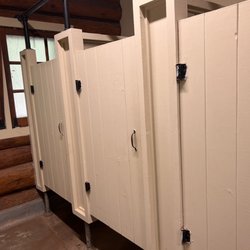
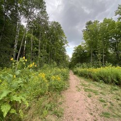
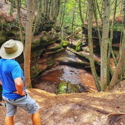
Hidden away in Gurney, Wisconsin-it was only a 23 minute (15miles) drive from Copper Falls State Park. Well, you're obviously into waterfalls-why not go to an less travelled waterfalls? Maybe this is a rhetorical question, but we didn't know that this little gem was so close by. Yes, there are steps to view the best vista of the falls. Believe me-it's worth it. Bring your sneakers or hiking boots because you are gonna wanna check out this area and it's not set up for lots of tourists (i.e. dirt trails not asphalt trails). Bathrooms are kinda rustic too. There's a shelter by the parking area. I only wish I could have gotten here by bicycle *sigh* read more
 - Hiking Near Me - Gurney, Wisconsin")


 - Hiking Near Me - Gurney, Wisconsin")


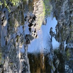
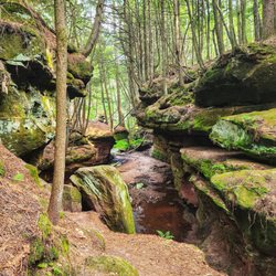
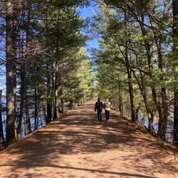
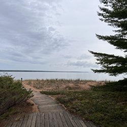
What an amazing place hidden away in northern Wisconsin! We were on our trek home from Bayfield and needed to avoid certain highways because of massive flooding and road wash-outs. Steve somehow found this park in a little google search of "waterfalls" and fell up on this place. I had never heard of it but we decided we would take a change and make a small driving detour to visit. You would never guess that a place this beautiful would be hidden away in the woods adjacent to farm fields. We first journeyed to the upper falls which is 130 odd stairs down a hillside and then we traversed down a slope grabbing tree roots and rocks. This is not a handicapped accessible park ya'll. The thing that I really love about this place is that noone really know it's there so there were very few people there (unlike the typical tourist traps like gooseberry falls). We had peace and tranquility and beautiful pictures without people marring the scenery. Then we journeyed down another 180 odd stairs to the lower falls that were even more beautiful than the upper. Plenty of stair and hill climbing but oh so worth it! I'm looking forward to bringing my hiking club friends here one day. They will love it! read more


3 years ago
6 years ago
We saw these falls first when we came into the area and boy, was that a mistake! I haven't hiked in over a year, so my legs are kind of out of shape. The next day, my calves were screaming in pain because of all the stairs you go up and down to get to these falls. The Upper and Lower Falls trails are clearly marked. The staircases to get to each of them may not seem like much to some people, but when I took a gander, I knew I was in trouble. I wish I had gone to the other falls in the area first and saved these falls for the end because when it came time to hike Copper Falls State Park the next day, my legs really hurt. But it's a great workout, that's for sure. I'm better off for it because now I know what it takes to prepare for my next excursion. The bathroom at the site was open and there was a covered area for picnicking. It takes less than an hour to see both falls, so this is a quick side trip to make if you've got the time. read more


7 years ago
More info about Potato River Falls
Falls Rd
Gurney, WI 54559
Directions
Hours
Outdoor Amenities
Ask the Community - Potato River Falls


Potato River Falls - hiking - Updated July 2026
Best of Gurney
People found Potato River Falls by searching for…
Things to Do in Gurney, Wisconsin
Hiking Trails With Waterfalls in Gurney, Wisconsin
Places to Take Pictures in Gurney, Wisconsin
Waterfalls in Gurney, Wisconsin
Public Showers in Gurney, Wisconsin
Walking Trails in Gurney, Wisconsin
Beautiful Views in Gurney, Wisconsin
Scenic Overlook in Gurney, Wisconsin
Attractions in Gurney, Wisconsin
Waterfalls and Swimming Holes in Gurney, Wisconsin
Scenic Views in Gurney, Wisconsin
Fishing Spots in Gurney, Wisconsin
Off Road Trails in Gurney, Wisconsin
View Points in Gurney, Wisconsin
Picnic Areas in Gurney, Wisconsin
Off Leash Dog Hikes in Gurney, Wisconsin
Things to See in Gurney, Wisconsin
Browse Nearby
Browse Brands
Browse Articles
People who viewed Potato River Falls also viewed
Copper Falls State Park
33 reviews
Houghton Falls Hiking Trail
5 reviews
Morgan Falls St. Peter's Dome Trail
6 reviews
Interstate Falls
1 review
Ottawa National Forest
3 reviews
Steep Creek Outfitters Whitecap Kayak
4 reviews
Prentice Park
2 reviews
Up North Guide Service
1 review
Howard Pearson Plaza Park
1 review
Ironwood Powersports
3 reviews