Prentice Park Photos


You might also consider
More like Prentice Park
Recommended Reviews - Prentice Park
Start your review...

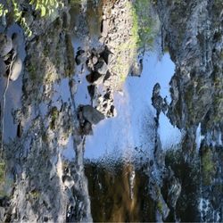
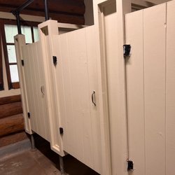
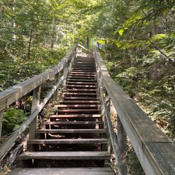
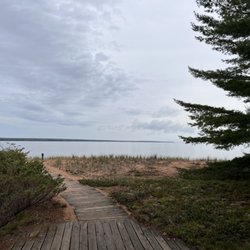
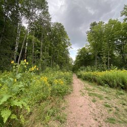
A big thank you to the City of Ashland for providing and maintaining such a lovely campground. We are in a 38' class A with a Jeep. Site 5 was perfect for us. There are 6 RV sites and tent sites. It is a first come first serve campground. Sites have water and 50 amp power. Site 5 is a pull thru, paved and level. The camp host was right there providing the shower code. There are deer, bunnies, an owl and lots of birds. Fire pits at each site and firewood is available for purchase. Wonderful bike/walking trails here as well. Just delightful! read more


More info about Prentice Park
Turner Rd
Ashland, WI 54806
Directions
Hours
Outdoor Amenities
Other Amenities


Prentice Park - parks - Updated June 2026
Best of Ashland
People found Prentice Park by searching for…
Things to Do in Ashland, Wisconsin
Hiking Trails in Ashland, Wisconsin
Playgrounds in Ashland, Wisconsin
Public Shower in Ashland, Wisconsin
Camping Sites in Ashland, Wisconsin
Places to Take Pictures in Ashland, Wisconsin
Walking Trails in Ashland, Wisconsin
Attractions in Ashland, Wisconsin
Playgrounds for Kids in Ashland, Wisconsin
Camping & Campsites in Ashland, Wisconsin
Waterfalls in Ashland, Wisconsin
Swimming Lakes in Ashland, Wisconsin
Picnic Areas in Ashland, Wisconsin
Tent Camping in Ashland, Wisconsin
Tourist Attractions in Ashland, Wisconsin
Scenic Views in Ashland, Wisconsin
Camping Cabins in Ashland, Wisconsin
Running Trails in Ashland, Wisconsin
Off Road Trails in Ashland, Wisconsin
Picnic Tables in Ashland, Wisconsin
Trending Searches in Ashland, WI
Berry Picking near Prentice Park
Boat Rental near Prentice Park
Cliff Jumping near Prentice Park
Fishing Spots near Prentice Park
Kayak Rental near Prentice Park
Public Pools near Prentice Park
Public Shower near Prentice Park
Scenic Overlook near Prentice Park
Swimming Holes near Prentice Park
Browse Articles
Browse Nearby
Browse Brands
Related Cost Guides
Related Searches in Ashland, WI
Best Fishing Locations and Guides in Ashland, Wisconsin
Best Nature Trails for Hiking in Ashland, Wisconsin
Best Pontoon Boat Rentals Near Ashland, Wisconsin
Best Spots for Star Gazing in Ashland, Wisconsin
Best Things to Do on a Rainy Day in Ashland, Wisconsin
Best Water Parks for Kids in Ashland, Wisconsin
Browse Top Hotels in Ashland, Wisconsin for Your Stay
Check Out Off Road Trails in Ashland, Wisconsin
Discover Free Parking Options in Ashland, Wisconsin
Discover Lakes & Ponds to Explore in Ashland, Wisconsin
Discover Popular Bike Trails in Ashland, Wisconsin
Discover Scenic Beach Camping Sites in Ashland, Wisconsin
Discover Stunning Skyline View Spots in Ashland, Wisconsin
Discover Top Boat Tours in Ashland, Wisconsin for All Ages
Discover Top Nature Parks to Visit in Ashland, Wisconsin
Discover the Best Fishing Lake in Ashland, Wisconsin
Discover the Best Night Hike Trails in Ashland, Wisconsin
Enjoy Hiking Adventures in Ashland, Wisconsin
Enjoy Scenic Night View Experiences in Ashland, Wisconsin
Enjoy Tent Camping Spots Around Ashland, Wisconsin
Enjoy a Relaxing Bed & Breakfast Experience in Ashland, Wisconsin
Enjoy the Best Night View Spots in Ashland, Wisconsin
Enjoy the Best Walking Trails in Ashland, Wisconsin
Explore Beautiful Parks and Green Spaces in Ashland, Wisconsin
Explore Easy Hikes Perfect for All in Ashland, Wisconsin
Explore Hotels & Travel Options in Ashland, Wisconsin
Explore Landmarks & Historical Buildings in Ashland, Wisconsin
Explore Nature Spots Around Ashland, Wisconsin
Explore Popular Boat Charters Near Ashland, Wisconsin
Explore Popular Campgrounds Near Ashland, Wisconsin
Explore Popular Picnic Areas Around Ashland, Wisconsin
Explore Popular RV Parks Around Ashland, Wisconsin
Explore Popular Scenic Overlook Points in Ashland, Wisconsin
Explore Scenic Lakes to Visit in Ashland, Wisconsin
Explore Secret Spots Worth Visiting in Ashland, Wisconsin
Explore Top Gyms in Ashland, Wisconsin Now
Explore the Best Trail Options in Ashland, Wisconsin
Family Friendly Hiking With Kids in Ashland, Wisconsin
Find Cozy Camping Cabins in Ashland, Wisconsin
Find Fun Kids Activities Outdoor in Ashland, Wisconsin
Find Picnic Tables for Outdoor Fun in Ashland, Wisconsin
Find Top Skating Rinks in Ashland, Wisconsin for All Ages
Find Top-Rated Waterfalls in Ashland, Wisconsin Now
Find the Best Playgrounds to Visit in Ashland, Wisconsin
Find the Best State Parks Camping Spots in Ashland, Wisconsin
Fun Indoor Activities to Try in Ashland, Wisconsin
Fun Teen Activities to Do in Ashland, Wisconsin
Great Places to Swim in Ashland, Wisconsin
People who viewed Prentice Park also viewed
Morgan Falls St. Peter's Dome Trail
6 reviews
Potato River Falls
7 reviews
Saxon Harbor Campground
1 review
Bayview Park
1 review
The Spot Supper Club & Resort
11 reviews
Apostle Islands Area Campground
19 reviews
Trek & Trail
71 reviews
Bayfield Guest House
1 review
Meyers Beach Kayaking
1 review
Mission Springs Resort
6 reviews