Palisade Head Photos


More like Palisade Head
Recommended Reviews - Palisade Head
Start your review...

Reviews With Photos

The views are definitely as beautiful as google image leads on, but safety is definitely a big concern. The drive up was a single lane paved road up a pretty steep hill, so drive slowly and with caution as cars will need to move to that side if there is 2-way traffic. There were a handful of parking spots up at that top, but on that day I visited, it was a bit like Tetris to park safety and be out of the way of the main road. Plan on going at non-peak times to avoid the busy crowds. The lack of guard rails on the cliff made for a thin line between "I want to look over the edge, but I also don't want to fall." I got close enough to look over that edge but not too close as my fear of heights would have quickly kicked in. The views are gorgeous and the lake was clear and blue. I visited on a nice fall day, past the peak fall colors time, but would love to see this view in the summer time or when the leaves are at their peak for fall colors next year!


Live life on the edge (without going over it) and check out Palisade! I love the north shore cliffs and this place has great views. You can drive right up and make this a short or long stop. If you have time, climb around the rocks and get different views. It was raining off in the distance to one side and blue skies facing the other way which made for some great photos. My legs felt jelly since you can walk along the sheer ledge and look straight down. The water is clear so you can actually see the rocks. Theres also plenty of wild flowers (in early July) and you can see them growing out the side of the cliff too. I saw one person getting ready to climb down the cliff but couldn't stay around to be nervous for him! I would definitely come back here, maybe grab some coffee in the morning and watch the sunrise. Yep that sounds about perfect for next time!


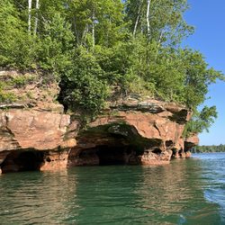
Amazing views!!! While driving down highway 61 along the North Shore be sure to make a stop here. You have to drive up a winding single lane road to the very top of the hill where there is a small parking area for about 10 cars. Be careful on the road because traffic is going in both directions so you will want to go slow and take caution. Once you make it to the top and park you will understand why this place gets 5 stars. The view of Lake Superior and the surrounding area is amazing. On a clear day you can see across the lake to the Wisconsin side. There are a few spots with rock walls to get close to the edge and still feel safe, but I recommend walking the rocks past the parking lot and sitting on the edge of the 200 ft cliff away from everyone else. I had an amazing time here just sitting on the edge staring off into the distance.

1 year ago


4 years ago
A short one mile hike for breathtaking views! My family and I did this hike during the end of March and I could only imagine how it would look during the fall! The road to drive up was closed for the winter so we hiked up the small mountain which took around 15 minutes. But during (not the winter season LOL) the road is open to drive up for gorgeous views of Lake Superior. Definitely a must stop you have to make while driving up the MN North Shore. read more


2 years ago
The views are definitely as beautiful as google image leads on, but safety is definitely a big concern. The drive up was a single lane paved road up a pretty steep hill, so drive slowly and with caution as cars will need to move to that side if there is 2-way traffic. There were a handful of parking spots up at that top, but on that day I visited, it was a bit like Tetris to park safety and be out of the way of the main road. Plan on going at non-peak times to avoid the busy crowds. The lack of guard rails on the cliff made for a thin line between "I want to look over the edge, but I also don't want to fall." I got close enough to look over that edge but not too close as my fear of heights would have quickly kicked in. The views are gorgeous and the lake was clear and blue. I visited on a nice fall day, past the peak fall colors time, but would love to see this view in the summer time or when the leaves are at their peak for fall colors next year! read more


The north shore is beautiful. This places offers a stunning view of the cliffs and great photo ops. However, parking may be limited and you may run into some climbers (such as I did). Nonetheless, do check it out if you're ever in the area, a must-see! read more
4 years ago
Live life on the edge (without going over it) and check out Palisade! I love the north shore cliffs and this place has great views. You can drive right up and make this a short or long stop. If you have time, climb around the rocks and get different views. It was raining off in the distance to one side and blue skies facing the other way which made for some great photos. My legs felt jelly since you can walk along the sheer ledge and look straight down. The water is clear so you can actually see the rocks. Theres also plenty of wild flowers (in early July) and you can see them growing out the side of the cliff too. I saw one person getting ready to climb down the cliff but couldn't stay around to be nervous for him! I would definitely come back here, maybe grab some coffee in the morning and watch the sunrise. Yep that sounds about perfect for next time! read more

6 years ago
Beautiful scenery at the top of Palisade Head. It's worth seeing. It offers breathtaking views of Lake Superior. read more

6 years ago
Awesome views of the lake and cliffs! Well worth the stop. Rock climbers were having a good time. read more

Amazing views!!! While driving down highway 61 along the North Shore be sure to make a stop here. You have to drive up a winding single lane road to the very top of the hill where there is a small parking area for about 10 cars. Be careful on the road because traffic is going in both directions so you will want to go slow and take caution. Once you make it to the top and park you will understand why this place gets 5 stars. The view of Lake Superior and the surrounding area is amazing. On a clear day you can see across the lake to the Wisconsin side. There are a few spots with rock walls to get close to the edge and still feel safe, but I recommend walking the rocks past the parking lot and sitting on the edge of the 200 ft cliff away from everyone else. I had an amazing time here just sitting on the edge staring off into the distance. read more


7 years ago
Just a short drive up a steep hill and you get to see a fantastic view! It was raging wind, misting, and foggy and also freezing when we were there so we didn't stay long but we were in awe! This is a great quick stop along the north shore. read more

6 years ago
8 years ago
16 years ago
More info about Palisade Head
Minnesota State Highway 61
Silver Bay, MN 55614
Directions
Hours
Outdoor Amenities
Ask the Community - Palisade Head
Review Highlights - Palisade Head


Why does Yelp recommend reviews?
1 review that is not currently recommended
The reviews below are not factored into the business's overall star rating.
6 years ago
Palisade Head - landmarks - Updated June 2026
Best of Silver Bay
People found Palisade Head by searching for…
Things to Do in Silver Bay, Minnesota
Hiking in Silver Bay, Minnesota
Cliff Diving in Silver Bay, Minnesota
Scenic Overlook in Silver Bay, Minnesota
Public Showers in Silver Bay, Minnesota
Scenic View in Silver Bay, Minnesota
Playgrounds in Silver Bay, Minnesota
Sunrise View in Silver Bay, Minnesota
Attractions in Silver Bay, Minnesota
Hiking With Kids in Silver Bay, Minnesota
Hiking Trails in Silver Bay, Minnesota
Photo Spots in Silver Bay, Minnesota
Beautiful Views in Silver Bay, Minnesota
Waterfalls in Silver Bay, Minnesota
Off Road Trails in Silver Bay, Minnesota
Places to Take Pictures in Silver Bay, Minnesota
Kids Playground in Silver Bay, Minnesota
Parks for Kids in Silver Bay, Minnesota
Picnic Areas in Silver Bay, Minnesota
Running Trails in Silver Bay, Minnesota
Lighthouses in Silver Bay, Minnesota
Stuff to Do in Silver Bay, Minnesota
Trending Searches in Silver Bay, MN
Browse Articles
Browse Nearby
Browse Brands
Related Searches in Silver Bay, MN
Affordable Kayak Rental Services in Silver Bay, Minnesota
Best Fishing Locations and Guides in Silver Bay, Minnesota
Best Lookout Points to Visit in Silver Bay, Minnesota
Best Spots for Star Gazing in Silver Bay, Minnesota
Best Water Parks for Kids in Silver Bay, Minnesota
Best Waterfalls and Swimming Holes in Silver Bay, Minnesota
Check Out Great Playgrounds in Silver Bay, Minnesota
Check Out Off Road Trails in Silver Bay, Minnesota
Discover Charming Historic Homes in Silver Bay, Minnesota
Discover Fun Activities to Do in Silver Bay, Minnesota
Discover Fun Kid Activities to Enjoy in Silver Bay, Minnesota
Discover Historic Sites and Places in Silver Bay, Minnesota
Discover Kid Friendly Beaches to Visit in Silver Bay, Minnesota
Discover Lakes & Ponds to Explore in Silver Bay, Minnesota
Discover Popular Bike Trails in Silver Bay, Minnesota
Discover Popular Photo Spots in Silver Bay, Minnesota
Discover Public Beaches to Visit in Silver Bay, Minnesota
Discover Top Nature Parks to Visit in Silver Bay, Minnesota
Discover the Best Beaches in Silver Bay, Minnesota
Discover the Best Caves to Explore in Silver Bay, Minnesota
Discover the Best Night Hike Trails in Silver Bay, Minnesota
Dog-Friendly Hikes With Dogs in Silver Bay, Minnesota
Enjoy Hiking Adventures in Silver Bay, Minnesota
Enjoy Scenic Night View Experiences in Silver Bay, Minnesota
Enjoy the Best Night View Spots in Silver Bay, Minnesota
Enjoy the Best Picnic Spots and Ideas in Silver Bay, Minnesota
Enjoy the Best Walking Trails in Silver Bay, Minnesota
Enjoy the Scenic Boardwalk Attractions in Silver Bay, Minnesota
Experience Stunning Sunset Views in Silver Bay, Minnesota
Explore Beautiful Castles and Landmarks in Silver Bay, Minnesota
Explore Beautiful Parks and Green Spaces in Silver Bay, Minnesota
Explore Free Things to Do Around Silver Bay, Minnesota
Explore Landmarks & Historical Buildings in Silver Bay, Minnesota
Explore Popular Campgrounds Near Silver Bay, Minnesota
Explore Popular Picnic Areas Around Silver Bay, Minnesota
Explore Popular RV Parks Around Silver Bay, Minnesota
Explore Popular Scenic Overlook Points in Silver Bay, Minnesota
Explore Popular View Points Around Silver Bay, Minnesota
Explore Scenic National Park Locations in Silver Bay, Minnesota
Explore Sunday Fun Things to Do in Silver Bay, Minnesota
Explore Top Art Galleries Located in Silver Bay, Minnesota
Explore Top Gyms in Silver Bay, Minnesota Now
Explore Venues & Event Spaces in Silver Bay, Minnesota
Explore the Best Trail Options in Silver Bay, Minnesota
Explore the Rich History in Silver Bay, Minnesota
Find Beautiful Views in Silver Bay, Minnesota
Find Exciting Tours to Take in Silver Bay, Minnesota
Find Fun Kids Activities Outdoor in Silver Bay, Minnesota
People who viewed Palisade Head also viewed
Black Beach
22 reviews
Two Harbors Lighthouse
7 reviews
Agate Bay Beach
3 reviews
Split Rock Lighthouse
57 reviews
Silver Creek Cliff Tunnel
1 review
Split Rock Lighthouse State Park
20 reviews
Northshore Scenic Overlook
1 review
North Shore Adventure Park
6 reviews
Lakeview National Golf Course
7 reviews
Temperance River State Park
19 reviews