Cancel

Open app

Search

Table Rock State Park

4.6 (50 reviews)

Table Rock State Park Photos

Recommended Reviews - Table Rock State Park

Your trust is our priority, so businesses can't pay to alter or remove their reviews. Learn more about reviews.
Yelp app icon
Browse more easily on the app
Review Feed Illustration

Reviews With Photos

Carrick Creek Trail

Went camping here over Mother's Day weekend. We were very impressed with the park and facilities. Plenty of hiking options inside the park and nearby. Wish the weather would have cooperated a little more for us, but we had such a memorable time!

HQ, has a lake, coffee, store, and all kinds of information!
Grace D.

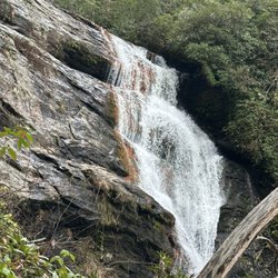
If you happen to be driving along the scenic highway in South Carolina's Upcountry, you can't miss Table Rock itself. A giant bald seated across an open field that just begs to be hiked, there are several entrances to the park itself, or free scenic viewpoints of the highway. The visitor center headquarters is free to visit; take a stroll by Lake Oolenoy, all with Table Rock as your backdrop. To hike to the summit is an intense 7.2 mile hike round trip that includes walking up steep mountainsides and careful footsteps in the side of Governor's Rock that are cut into the stone themselves. I made it with a dog, he probably did better than I did! I did have to bring water for him, as the creek ran across the trail only in some places, so keep that in mind if your four legged friend is tagging along! Otherwise, the view over Lake Jocassee was spectacular at the top! Happy hiking!!

Table Rock Historical marker (back)
RA J.

Table Rock is always a beautiful place to go see nature in all of its splendor while in the Update of SC. I wish I had time to go and hike the trails but maybe another time. If you enjoy hiking (easy and difficult) , nature, relaxation, fishing, then you have to go to Table Rock. These photos are not from the actual park or close to Table Rock.

Andrea W.

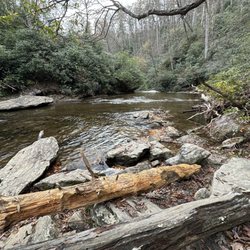
Came here on a weekday morning around 9AM, $6/person for parking (there were rangers checking when we got back around 2:30PM). Didn't see many people on the Table Rock trail, hike wasn't too steep although it goes uphill, well-marked trail with trail blazers. There's a spot about 1.5 miles in with a spot to sit and admire the view. Rocks are a bit slippery due to rain but not too bad, hiking poles could possibly help. Lots of dead trees and lots of leaves on the ground. View at the top was good, saw the lake below, not too windy and was pretty great!

The waterfall at the bottom.  It was hard to leave the cool, clean water, and sitting under the falls was perfect for a waterfall massage.
Nick F.

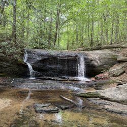
One of my top 5 hikes for combination of challenging hike and amazing views at the top! It is a March to the top, but is so well worth it. There are some really cool sections where you're walking past prehistoric sized boulders, and then towards the top there are huge sections of rock to warm up on if its sunny. Everyone I ran into was so incredibly nice. Southern folks are the best! After you make it back down, make sure to swim in the waterfall near the start of the trail for an indescribably refreshing dip.

Blue ridge mountains
Christopher C.

Great hike with a good view at the table rock summit. Keep going past the sign and down the rocks to get the lake view. Takes about 5 hours round trip.

Jonathan B.

This is a good state park. There's a nice watering hole at the trail head that seems to attract a majority of the visitors. The staff are fairly friendly and helpful - lots of younger ladies that seem to be here for a part time job. The parking/entrance fee is per person rather than per vehicle which is not so great in my opinion. I guess I don't mind supporting our public lands though. So be it. The trail was nice - you almost immediately find yourself at a wide stream with picturesque waterfalls and exposed rock outcrops. You can swim in the water or just take your shoes off and dip your achy feet from the hike. About a mile up the trail we saw a wild bear. And inside the shop/building at the trail head there are a few caged reptiles. Snakes are awesome to look at. Both shops have some unique gifts, post cards, stickers, magnets, clothes and other memorabilia. I would recommend giving them a shot. Just hide your family members when you pay for entry.

Table Rock State Park
Evan G.

Table Rock State Park in Pickens is a really cool state park in the mountains that has many features that make it worth a visit including really well maintained trails, waterfalls, and a lake. I really like how well everything is maintained and it is easy to navigate and get some fresh air. I have enjoyed the park every time I have been here and have had a lot of fun and memories.

John C.

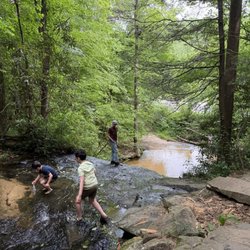
A great park for summertime hiking. There are hikes from an easy 2 miles, 7 miles to the top of table rock mountain or longer ones that go to the other side of the park. Near the parking lot, there is a lake with a diving board for swimming. The 2 mile hike goes next to a stream where you get to walk through and next to it for quite a while. There is even a little swimming area under a waterfall near the beginning of the hike to cool off either before or after the hike. This is a staple for the area and a great hike no matter the level. We did the 2 mile hike with a 2 and 4 year old. The really enjoyed seeing all the bugs and wildlife and splashing in all the little areas where the creek intersects with the trail. The guard shack has a gift shop and a place to see some snakes and other animals. Love this place!

Daniela V.

Absolutely worth every step up! Keep pushing the view is absolutely breathtaking. Once you get to Governors Rock, enjoy the view and be ready for the last couple of miles and you will make it to the TOP! Great hiking trails!! Clean and the staff was so welcoming thank you for making our trip here memorable

Table Rock
Meghan G.

Well kept state park, with plenty to do. We got to the park around 10:45 AM on a Thursday, and paid the $5 per adult to utilize the park. It was not busy at all. There are plenty of well marked signs for the parking area, along with where the trail head starts. We opted to do the Carrick Creek Loop trail (moderate), which was well marked with green blazes. The path was beautiful, with multiple waterfalls and many man made rock steps through out. After the hike, we swam in Lake Pinnacle which was a great cool down. There is a sandy beach area with picnic benches for lunch. On days when there are lifeguards, park goers are able to use the low and high dives on the lake. There is a clearly labeled calendar on their website of when life guards are present. Overall a nice day! Looking forward to working up to the Table Rock and Pinnacle Mountain trails.

Landscape view
Filip M.

Really nice park, around 5 different trails with different difficulty. We took the Table Rock trail which was 3.6 miles uphill one way. Definitely worth it!

Near nature center
Lareina W.

We stayed in cabin 3, it was beautifully appointed. AC, firm but comfortable beds, looks to have been recently renovated. Fun camping/cabin experience. We will definitely return!

Lake

See all

7 years ago

Helpful 0
Thanks 0
Love this 0
Oh no 0

7 years ago

Helpful 0
Thanks 0
Love this 0
Oh no 0

6 years ago

Very peaceful and relaxing. A very nice place to kick back by the fire and forget the daily grind for a little while.

Helpful 0
Thanks 0
Love this 0
Oh no 0
Photo of Scott C.
163
14
4

15 years ago

Helpful 0
Thanks 0
Love this 0
Oh no 0

8 years ago

Helpful 0
Thanks 0
Love this 0
Oh no 0

7 years ago

Helpful 0
Thanks 0
Love this 0
Oh no 0

15 years ago

Helpful 0
Thanks 0
Love this 0
Oh no 0
Photo of keeley m.
132
62
5

11 years ago

Helpful 1
Thanks 0
Love this 0
Oh no 0
Photo of Lucy E.
5
56
206

10 years ago

Helpful 2
Thanks 0
Love this 0
Oh no 0

11 years ago

Helpful 0
Thanks 0
Love this 0
Oh no 0

Page 2 of 2

Ask the Community - Table Rock State Park

We would like to visit a State Park near Greenville, but we are looking for at least one or two areas that might be wheelchair accessible, any suggestions?

Contact the park if they can accommodate 2 wheelchair sites at the same time. Have fun!

View All 3 Questions

Review Highlights - Table Rock State Park

Favorite hiking in the Upstate that I have tried (of Paris Mtn, Dupont Park, Caesars Head).

Mentioned in 4 reviews

Read more highlights

Verify this business for free

People searched for Hiking 355 times last month within 15 miles of this business.

Verify this business

Riley Moore Falls

Riley Moore Falls

5.0(4 reviews)
33.8 mi

This is the best waterfall we got to visit in SC this far. After we left Reedy Branch Falls we…read moredrove here. Well, as close as we could get. I didn't realize that we couldn't drive all the way to the trailhead so we had a long hike in store due to me having to carry my toddler most of the time. I should have re-read the previous reviews before coming. My friend did help me carry her as well and for that I was very thankful. So definitely don't recommend this hike with a little one unless strapped in a carrier. Also, I don't recommend it for the elderly either. It's definitely a wilderness hike deal with roots and elevation change. In fact, it's mostly downhill on the way to the falls, but on the way back it's pretty much all uphill, which was not fun with aforementioned young child. It's about a half mile to the actual trailhead and then another 0.7 mile to the falls. That's about 2.4 miles round trip. The reason of course that my boys absolutely became enamored with this place is the large swimming hole. It is wonderful and has plenty of space. The waterfall itself is beautiful and although it's not as tall as others, its width is quite impressive. I was trying to get as close as I could and even noticed a hidden part of the falls inside of the rock structure. That was so cool!! The sand at the base and shore give it a beachy vibe. We definitely packed it in and out making sure not to leave anything behind as to preserve the area as best as possible. Needless to say we were wiped by the time we made it back to our vehicles, but we're still glad we decided to venture here. Coming back with my hubby and boys in the very near future. Happy yelping!

I just wanted to update my 3/15/20 review below to add I've now done this hike several times, but…read moreTHIS time I had the chance to hike it with a friend who is directly related to the namesake of the waterfall... Riley Moore. Sandie is a church friend of mine and Riley Moore was her Great Great Uncle (I believe that's right). He once upon a time operated a grist mill here at the top of the falls. She's been trying to get here to see the waterfall, but couldn't find it and wanted to join us (along with her family) since I knew the way. Upon further research I discovered there are actually still remnants of the mill including visible drill holes, spikes and bolts. Thought that was pretty cool info to share! [ [ [ PREVIOUS REVIEW ] ] ] Riley Moore Falls is small in height but HUGE in personality. It's located off State Road S37-748, which is a nicely maintained gravel road where cars and trucks alike can comfortably traverse. ~~~ DIRECTIONS From Westminster, SC - DO NOT turn onto Cobb Bridge Road from Long Creek Hwy (Hwy 76) where you will see the brown & white sign pointing you in the direction of Riley Moore Falls. Our GPS had us go this way, then left onto State Road S37-748, but the road was CLOSED during our visit! INSTEAD, turn onto PU-32 also known as Rocky Fork Road. Turn left onto a gravel road near Rocky Fork Baptist Church and follow that until it dead ends @ State Road S37-748 (also known as Spy Rock Road). Turn right and drive approx. 1.4 miles (4 minutes) to 748c (aka Riley Moore Shoals Road). Park at the intersection of State Road S37-748 and 748c. DO NOT ATTEMPT TO DRIVE 748c in a car or minivan. Low clearance vehicles will find the terrain on this road to be VERY difficult to navigate without bottoming out or getting stuck. I'd also recommend 4x4 capability on wet days! There can be several deep-pocketed muddy areas after heavy rains. ~~~ THE TRAIL Once you reach the intersection of Spy Rock Rd (S37-748) and 748c, park roadside on Spy Rock, secure your vehicle and begin your hike approx. 1/2 mile down the "primitive road." IF you have a high ground clearance SUV or truck, you can drive the primitive road another half mile or so to a second parking area near the trailhead. The primitive road is VERY BUMPY  and can be muddy in spots after heavy rains, so a 4x4 is best. After reaching the second parking area, follow the marked trail on the left!!! The trail is a little over a 1/2 mile to the falls from here. The trail is fairly straightforward and easy to follow. ~~~ THE FALLS Once you reach the Chauga River, you will notice a large sandy area with plenty of room for an entire horde of hikers!!! Riley Moore Falls is not very tall (only about 12 feet), but it is very wide and has a deep base pool. PRO TIP - Bring swimwear, towels and a picnic, but be sure to pack it in and pack it out. ~~~ THINGS TO KNOW Hiking Distance: 2 miles (round trip to falls from S37-748) Difficulty of hiking 748c: All downhill to trailhead (moderate return) Difficulty of hiking trail to falls: EASY Creek Crossings: NO Elevation Gain: 357 feet Waterfall Height: Approx 12 feet Access to top of falls: NO - not without getting wet Access to base of falls: YES Pool of water @ base of Falls: YES Sitting areas @ base: YES + sandy beach RESTROOMS: NO PARKING: YES (along road) + secondary parking area closer to trailhead for trucks and high ground clearance vehicles with room for about 6 cars. ~~~ [ FINAL THOUGHTS ] A lovely waterfall in any season, but also a great spot for a summer swim. While we had the waterfall practically to ourselves during our Mid-March expedition, be advised other trail website reviews say it gets trashy & crowded in summer months. What a shame if that is true because it truly is a treasure. ENJOY! 2022 / 74 #UPDATE 178

Photos
Riley Moore Falls
Riley Moore Falls - CREATED FROM GOOGLE MAPS

CREATED FROM GOOGLE MAPS

Riley Moore Falls

See all

Thompson River Waterfalls

Thompson River Waterfalls

5.0(2 reviews)
17.3 mi

IF you want a challenging hike and are looking to score a bunch of amazing waterfalls on the SAME…read moreTRAIL, the Thompson River Waterfalls trail is your Huckleberry!!! Google maps has labeled the trailhead HIGH FALLS TRAIL HEAD just off Whitewater Road. As you turn onto Brewer Road, you will see a wide trail entrance on the corner. We parked along the side of the road near the entrance. There are multiple waterfalls along the trail as Thompson River makes its run down the mountain, dropping approx. 1,900 feet over 5 miles as it makes is way to beautiful Lake Jocassee. There are seven names waterfalls along the trail and 3 that absolutely should not be missed: HIGH FALLS, RICH FALLS & BIG FALLS aka THOMPSON FALLS. THE TRAIL The trail initially ascends about 60 feet but remains at a fairly consistent decline of about 500 feet along the entirety of the main trail. First up was REID FALLS at around .9 miles, but we decided to skip it. A split in the trail at around 1.1 miles leads to HIGH FALLS, a gorgeous 50 foot sliding ribbon waterfall. There really is no way to get an excellent picture of the falls without getting wet. The best vantage of the falls is across the river and a scramble over some large boulders to a beach like area. The pool in front of the falls is better than 6 feet deep, but most of the shallow areas were only ankle or calf deep. Back along the main trail we continued our descent down the mountain and next came to SIMON FALLS, which we also opted to skip. All of the falls (except High Falls) require a scramble downhill to view. Reid and Simon Falls have the least steep scrambles, but we wanted to conserve our legs for Big Falls, the steepest of the scrambles. We also bypassed Rich Falls around the 3.8 mile mark as we decided it would be best to see how we feel after tackling Big Falls. BIG FALLS Listen, however easy the trail seemed up until this point was about to SEVERELY change! The descent to the falls is about 535 feet in less that a quarter of a mile. IT IS VERY STEEP and some areas require sitting on your butt and sliding, other require holding on to low branches or roots and one area in particular requires mild vertical rock climbing. NOT KIDDING! But all of it is doable if you take your time and don't have any serious physical or health challenges. All of the MAIN trail is very easy to follow, but I would highly recommend downloading the ALLTRAILS map because it shows the exact entry points for the side trails to each of the falls. The side trail to Big Falls is easy to follow, but can be very faint in some areas. Once you make it down to the river, look for a side trail just before the final descent to the riverbank. It will lead you through a thicket of vegetation that leads to a boulder entrance to the falls. Navigate them as best you can to get to a great vantage point to view the falls. If you are not skilled at boulder hopping, this area will be very intimidating! But you MUST do it in order to view the Big Falls, which is not visible otherwise. NOTES / TIPS ~ Download ALLTRAILS MAP prior to your drive to the trailhead ~ There are 3 river crossings and yes you will get wet ~ Most of the falls require getting wet for best view ~ No restroom facilities at the trailhead ~ BRING PLENTY OF WATER & SNACKS FINAL THOUGHTS On our return, we were just too exhausted to attempt to see Rich Falls, so instead we used every ounce of energy we had remaining to make it back to the car. I was thoroughly exhausted. The 3.5 miles back seemed more like 10 and we'd run out of drinking water during our time at Big Falls. I recommend a minimum of five 16oz bottles to do this hike and more if you bring salty snacks. I'd also recommend you chug one bottle at the parking area before you begin. All in all this is an amazing trail full of gorgeous waterfalls. Big Falls easily has become one of my top 5 favorite southern waterfalls... but it is a beast of a hike! ALLTRAILS LINK: https://www.alltrails.com/explore/trail/us/north-carolina/thompson-river-waterfalls?mobileMap=false&ref=sidebar-static-map 2023 / 12

A series of gorgeous waterfalls along beautiful Thompson River as it makes its way from the higher…read moremountain elevations down to the Jocassee River. The trail offers a great experience for anyone at any hiking level. If you are like me and prefer more leisurely hikes, The first three waterfalls (Reid Branch, High Falls & Simon Falls) are fairly easy to reach. High Falls in particular is great for families with small children and has a wading pool of water at its base of different depths. There is even a small beach like area to relax and have a picnic. Just know you must get wet in order to reach the beach area, which also has the best view of the falls since High Falls kind of sits recessed into a little nook making it difficult to see in its entirety. But for those who are more like my husband and don't mind a more difficult hike, Rich Falls and Big Falls further downstream will give you plenty of challenge. Although I must say, my husband was sore several days after his hike and while he thought Big Falls was stunning, he was miserable on the return. He said the side trail to Big Falls was extremely steep and challenging, both on the way down and especially on the climb back out. It drained him completely at age 54 and he still had to endure a 3.5 mile hike back to the car running on empty. Knowing him he'll do it again! MEN... LOL Also near the parking area is a trail leading to White Owl Falls. A very short hike to a beautiful 20 foot waterfall. Walk west on Whitewater Road from the parking area and look for an opening with a pink ribbon tied to a tree branch about 900 feet from the trailhead.

Photos
Thompson River Waterfalls - HIGH FALLS on Thompson River is approx. 50 feet tall

HIGH FALLS on Thompson River is approx. 50 feet tall

Thompson River Waterfalls - HIGH FALLS on Thompson River is approx. 50 feet tall

HIGH FALLS on Thompson River is approx. 50 feet tall

Thompson River Waterfalls

See all

Wildcat Branch Falls - View of one of the falls in the hike (you cross stones as part of the trail).

Wildcat Branch Falls

4.9(15 reviews)
6.5 mi

There are a variety of places to hike around the area. This would be the short hike with bang for…read moreyour buck. I made a loop in 45 minutes or so from the parking area with what is apparently an established food stand. There isn't a lot of space between the parking area and the side of the highway, so be ready. The scenery revolves around several waterfalls, the highest of which surprised me with its size. There is an excellent variety of terrain for a short scamper, and while it is an incline, people with milder mobility limitations could still reasonably expect to get to the falls in time. There is no charge to enter, and plenty of reason to make the falls part of your day.

Family hike #9; yay! Hubby and the boys hiked this trail back in October 2024 while we were…read morecamping, but I decided not to join, because my then nearly 2-year-old toddler was a sprinter (still is) and I didn't trust to take her on this journey. Didn't take her with us this time either; haha. Anyway, they were nice enough to agree to return to Wildcat Wayside with me. 3 waterfalls for the price of 1, except there is no price, because it's free! The hike was lush with foliage and a lot of the rhododendron blossoms had already fallen on the trail; I never knew they were so pretty. Saw lots of snails on leaves, millipedes, mushrooms; it was fantastic finding living treasures! Upper Wildcat Branch Falls was a slight disappointment to me as I expected more of a rush of water since it rained quite a bit the couple of days before, but it's height is still impressive. My boys also found salamanders and even a tiny baby axolotl in the water! I was blown away. To me the hiking trail was easy even with the stairs. I think I finally have built up a tolerance, because my legs no longer hurt after hikes I go on. It's only about a mile long, so it's not too bad, but there is elevation change and people who aren't used to it may find it somewhat challenging depending on stamina. I wonder if Pauly's Gourmet Peanuts Truck still comes around on the weekends, because it wasn't there on a Wednesday; would've liked to check it out. The trail was somewhat busy with hikers, but definitely not overrun. The weather was perfect for hiking, but it was cooler than expected. I should have been brave and joined the polar bear club with cold immersion in the swimming hole at Lower WBF, but alas; hopefully next time. No bathroom facilities are available here, so go before you come. On to hike #10! Happy yelping!

Photos
Wildcat Branch Falls

See all

Secret Falls

Secret Falls

5.0(3 reviews)
26.7 mi

Wanna know a secret???…read more There are waterfalls all over this region of the South just waiting to be discovered. Many are known and many more are unknown. While I've been hiking this area for nearly a decade, I only recently heard about this waterfall for the first time last year (2019). A well kept local secret indeed... but y'all dun let the wrong yelper discover this waterfall and the secret is about to be let out! [ THE DRIVE ] There are a shocking amount of natural waterfalls located on private property throughout this area. Thankfully this is not one of them and it can be enjoyed by all. The gravel road to the trailhead is known as Big Creek Road. Since we were coming from the King Creek Waterfall area near Tamassee SC, GPS lead us to the eastern end of Horse Cove Road, which is also known as Bull Pen Road closer to the Chattooga River (where you pass over a cool old iron bridge). I tell you these details because if you happen to follow our driving route on a week after heavy rainfalls, you are likely to see a great number of unnamed waterfalls off in the woods. We counted 5, and only one of them was a named waterfall on Google maps (Scotsman Falls). [ THE EXPERIENCE ] We traveled along Walking Stick Road until it took a sharp right turn towards Big Creek Road. On the day we visited, there was a locked gate blocking the drive onto Big Creek Road, so we parked in a small little niche near the gate and walked about 200 yards to the Secret Falls trailhead (which is marked with a narrow sign). The trail was very muddy, but the descent was slow and steady for the majority of the half mile hike. However, it gets considerably steeper as you approach the portion of the trail leading to the base of the falls. Here you will see poorly maintained wooden timbers actings as steps.They were so poor in fact, that we opted not to use them and walked alongside them. The waterfall was raging from all the recent rain, which limited some of our photo opportunities. It is a gorgeous waterfall with picturesque cascades both above and below it. The cascades below comes as the river takes a sharp left turn just past the pool of water at the base of the falls. Accessing the upper waterfall area is easily done by using a small obvious trail off to the left just before the wooden steps. A downed tree forces you to scramble over it and around large rhododendrons that are bent over from the weight of the fallen tree. Once through the brush, you will be directly on top of the falls, so be careful and exercise good judgement. [ THINGS TO KNOW ] Hiking Distance: 1.3 miles Difficulty: Easy and family friendly (but can be muddy) Creek Crossings: YES (3) Elevation Gain: 255 feet Waterfall Height: Approx 45 feet Access to top of falls: YES Access to base of falls: YES Pool of water @ base of Falls: YES Sitting areas @ base: YES RESTROOMS: NO PARKING: YES if gate is open. [ FINAL THOUGHTS ] THE SECRET IS OUT!!! This is a great waterfall for an easy family adventure. We came in the winter, but seems this would be a great picnic spot where kids could play in the water for hours in the summer. The drive to nearby Highlands, NC is only about 6.5 miles away for plenty of food options and even more waterfall adventures. Near Highlands are a number of GREAT waterfalls with very short hiking distances including Ranger Falls, Bust Yer Butt Falls, Bridal Veil Falls, Cullasaja River Falls and our personal favorites: Glen Falls, Dry Falls, Mud Falls and Estatoah Falls (which is hidden just next to the Sky Valley Scenic Overlook). ENJOY!!! 2020 / 4

I was somewhat surprised that there are not more reviews of this trail/waterfall. I believe that…read morethe real name of this falls is Big Shoals Falls. In his book on NC waterfalls, Kevin Adams referred to it as Secret Falls and the name seems to have stuck. For years, there was no official trail to this waterfall and the one unofficial trail which existed traversed private property. I've been visiting the area for thirty years and this (October 2021) was my first visit to this waterfall. Bottom line: It is awesome. Truly one of the more beautiful waterfalls that I've been to. I have to disagree with the previous reviewer: IMO, this trail is in horrible shape. Granted, reviews like these are entirely subjective. But I would definitely not bring young children or dogs here. When I visited, the trail was really in bad shape. The first part of the hike was fairly easy. But the farther you go, the worse the trail becomes. Erosion had taken a terrible toll. There are many rutted and washed-out areas. Some were so bad that hikers have bypassed the trail completely. The final descent to the base of the falls was the worst. Wooden steps had been constructed. But the erosion was so bad that much of the soil behind the steps had washed out making the steps all but unusable. There are two water crossings on the trail. One was a couple of planks stretched across a small branch. The other was on a split log over a somewhat larger stream. Neither was too difficult. Then again, the faint-of-heart would probably not care for either one. Trekking poles helped me on both. I was not able to find a path to the brink of the falls. I tried one crude path which seemed to be incredibly choked with rhododenron. So I gave up on getting to the top of the falls. There is a much smaller cascade downstream of the main falls. As with the brink, I could not figure out how to get to it. I visited early in the morning and had the place all to myself. The lighting wasn't terrific. I'm not sure what time or sky conditions are ideal for photography. I drove in on Rich Gap and Big Creek Roads off of Hwy 28 south of Highlands. It wasn't too bad of a drive in my 2WD F-150. But I believe that the drive out on Walking Stick Rd to Horse Cove Rd east of town was easier. If you love waterfalls, definitely put this one on your must-see list. But be aware of the fact that the hike is a challenge. Not so much due to elevation change (which is moderate) but, rather, due to the overall condition of the trail.

Photos
Secret Falls - Have to walk over this water

Have to walk over this water

Secret Falls - Cross the tree

Cross the tree

Secret Falls

See all

Todd Creek Falls - The trail becomes more beautiful past the falls and leads to a large lake

Todd Creek Falls

3.3(4 reviews)
20.1 mi

July 28 2025 - Todd Creek Falls Trail is too overgrown with high bushes from both sides the first…read more1/4 part of trail with thorns, poison ivy, etc. And the area around the small pool area at the base of waterfalls is also overgrown and difficult to approach. The trail continuing on from the waterfall into the woods is not approachable at all. Spring and late fall are best to navigate. Too bad there isn't a group that could keep the trail better managed. Otherwise, the falls is running full and beautiful. Normally, a wonderful place to visit and cool off in the summer.

This trek gets high marks because it is a quick, easy hike to beautiful waterfalls and a…read morewell-maintained trail. The trail isn't well-marked at the head but it is quite easy to follow. It's maintained and well-used. Park at the clearing on Brookbend Road near the bridge and cross the street and head South. The power lines are quite visible and the trail is on the right-away under them. It's maybe a half mile to the waterfall which will be visible to your right. Head downhill and enjoy the beauty from many spots. Continue forward beyond the falls and the trail is much nicer. It meanders through the forest and you can see the spillway from the dam. Be careful, but you can actually walk on it but you are risking your life by doing so! The spillway provides a nice waterfall as well. The trail continues and becomes a loop or it can be followed to the lake. The negatives: aside from the powerlines and the lack of marking on the trail head, this place should have a map posted to indicate what the history is and where you are. A missed opportunity! Head to Waldrop Stone Falls, which is very close when you are done!

Photos
Todd Creek Falls - Waterfall

Waterfall

Todd Creek Falls
Todd Creek Falls

See all

Table Rock State Park

Table Rock State Park

3.8(6 reviews)
0.2 mi

Campground Pros and cons:…read more Pros: -Lake was clean and perfect to swim in -Everyone respected quiet hours -Staff at check in was fabulous -Bathroom close by -clean Cons: -No playgrounds in the campgrounds -Neighbors fire pit smoked for two days straight. Heavy billowing smoke and nothing the camp host would/could do about it. Not sure why rangers don't address the issue. Our throats were raw and we could not sit outside. We ended up leaving a day earlier than scheduled. -pricey for state campground. 60 bucks a night for a campsite.

We spent Labor Day 23 at table rock State Park in Pickens South Carolina. Overall not a good…read moreexperience. The park had quiet hours at 10 and for the most part people respected The quiet time and the staff was super friendly. The main reason we disliked this park was the smoke. Many of the campers either did not know how to light and maintain a fire or the campground is selling wet wood but either way the smoke was overwhelming and made it miserable. The Rangers should absolutely have addressed the smoke issue by going to each of the campsites and finding out what was going on.. One of our campsite neighbors had smoke going for two days straight and it was unbearable. In addition the sites were way too close together for such a beautiful park it could've been laid out to keep everybody happy and maintain some privacy. Lastly, the park is very expensive compared to other state parks.

Photos
Table Rock State Park - Halfway point. The following half is twice and difficult as the first half so keep that in mind!

Halfway point. The following half is twice and difficult as the first half so keep that in mind!

Table Rock State Park - Kids an grandkid chilling

Kids an grandkid chilling

Table Rock State Park

See all

Table Rock State Park - hiking - Updated May 2026

Loading...
Loading...
Loading...