Snowgrass Flat Trail Photos


More like Snowgrass Flat Trail
Recommended Reviews - Snowgrass Flat Trail
Start your review...

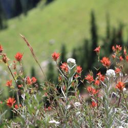
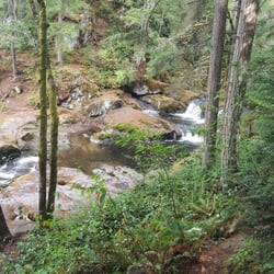
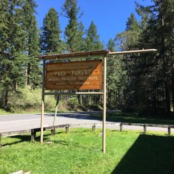
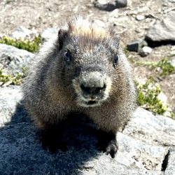
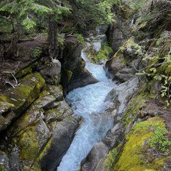
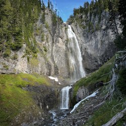
CGI can't create THIS. Poets are inspired by THIS. Painter's canvases are made for THIS. Singers muse about THIS. My legs gravitate to THIS. THIS.....is Snowgrass Flat in the Goat Rocks Wilderness. When it comes to hiking the Cascades, sadly, I'm a creature of habit. I have favorite hikes which I rinse and repeat annually. This is a bad thing when you have miles and miles of lands full of the most beautiful color, scenery, experiences to be had. Snowgrass Flat is now added to my repetoire of go-to places for Cascadian hikes. With a trailhead located south of Packwood, one must venture for about 45min along a dusty gravel road (it's about a 15-17mile trek; while in your car, you will feel like a sock in a washing machine due to the washboarded road). And I'm not kidding about the dust, it's a dustgasm. But it's all worth it. The trailhead was fairly filled with many a hiker's vehicle (but on the trail, we didn't see too many). The trail starts with a quickstep along the side of a pine-filled mountain---every once in a while you'll be afforded views of Mt. Adams to your right. There is water on this trail, and you may cover a bog or two, streams, and at mile 1-2 a torrent which is handled by a nicely-built bridge. Due to the water, there are some boggy-ness, and with this there can be some mosquitoes, but we didn't come across much on our way up (perhaps the bug spray helped...or maybe I just wasn't tasty enough). If you want a workout, you will have one. It doesn't slap you upside the head, but it's a nice, slow, long burn---so it's nice. After about 2-3hrs (around Mile 5-6 for us), the horizon starts to open up and you feel like you are reaching the top. This is the Flat That Is Snowgrass. You are in meadows galore. For some reason the sky is bluer, the waters are clearer, the craggy snow-covered peaks are breath-takers....it's everything a hike should be. There are many options for camping. Here you can see St. Helens in hazy distance, and Mt. Adams is there to taunt. Other sights are Goat Lake to the north---it's captured in what appears to be an eternal winter. The biggest feature would have to be Old Snowy and his mountain homies. If you have the time, my friends told me that Goat Lake and Old Snowy are excellent additional trips one can take from Snowgrass Flat. **mental note made** I can't wait to come here again. This is why I love Washington state. This is why I hike. THIS is brought to you by the YELP-1200. read more


More info about Snowgrass Flat Trail
Packwood, WA 98361
Directions
Visit Website
http://www.wta.org/go-hiking/hikes/snowgrass
Hours
Outdoor Amenities


Snowgrass Flat Trail - hiking - Updated July 2026
Best of Packwood
Browse Brands
Related Searches in Packwood, WA
Affordable Kayak Rental Services in Packwood, Washington
Best Fishing Locations and Guides in Packwood, Washington
Best Places for Horseback Riding in Packwood, Washington
Best Spots for Star Gazing in Packwood, Washington
Best Waterfalls and Swimming Holes in Packwood, Washington
Check Out Off Road Trails in Packwood, Washington
Discover Popular Photo Spots in Packwood, Washington
Enjoy Camping Adventures Around Packwood, Washington
Enjoy Tent Camping Spots Around Packwood, Washington
Enjoy the Best Tubing Experiences in Packwood, Washington
Explore Beautiful Parks and Green Spaces in Packwood, Washington
Explore Bike Rentals Throughout Packwood, Washington
Explore Fun Activities to Do in Packwood, Washington
Explore Popular Campgrounds Near Packwood, Washington
Explore Popular RV Parks Around Packwood, Washington
Explore Scenic Lakes to Visit in Packwood, Washington
Explore Top Dog Parks in Packwood, Washington Near You
Explore the Best Boating Spots in Packwood, Washington
Explore the Best Swimming Holes Around Packwood, Washington
Family Friendly Hiking With Kids in Packwood, Washington
Find Cozy Camping Cabins in Packwood, Washington
Find Top Skate Parks in Packwood, Washington for All Skill Levels
Find the Best Playgrounds to Visit in Packwood, Washington
Find the Best Swimming Pools in Packwood, Washington Today
Hiking Trails With Waterfalls in Packwood, Washington
Locate a Public Shower Facility in Packwood, Washington
Must-See Tourist Attractions Around Packwood, Washington
Popular Kids Activities in Packwood, Washington
Popular Things to Do in Packwood, Washington
Relax at Natural Hot Springs Near Packwood, Washington
Safe and Fun Parks for Kids in Packwood, Washington
Top RV Campgrounds to Visit in Packwood, Washington
People found Snowgrass Flat Trail by searching for…
Hiking Trails in Packwood, Washington
Star Gazing in Packwood, Washington
Things to Do in Packwood, Washington
Tent Camping in Packwood, Washington
Attractions in Packwood, Washington
Easy Hikes in Packwood, Washington
Secret Spots in Packwood, Washington
Scenic Overlook in Packwood, Washington
Waterfall Hike in Packwood, Washington
Tourist Attractions in Packwood, Washington
Camping in Packwood, Washington
Trails in Packwood, Washington
Walking Trails in Packwood, Washington
Secluded Spots in Packwood, Washington
Off Road Trails in Packwood, Washington
View Points in Packwood, Washington
Dog Friendly Trails in Packwood, Washington
Off Leash Dog Hikes in Packwood, Washington
Free Campgrounds in Packwood, Washington
Stargazing in Packwood, Washington
Things to See in Packwood, Washington
Lakes for Swimming in Packwood, Washington
Trending Searches in Packwood, WA
Boat Rental near Snowgrass Flat Trail
Fireworks near Snowgrass Flat Trail
Off Road Trails near Snowgrass Flat Trail
Public Shower near Snowgrass Flat Trail
River Swimming near Snowgrass Flat Trail
Strawberry Picking near Snowgrass Flat Trail
Swimming Holes near Snowgrass Flat Trail