RMI Expeditions Photos


You might also consider
More like RMI Expeditions
Recommended Reviews - RMI Expeditions
Start your review...

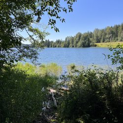
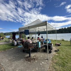
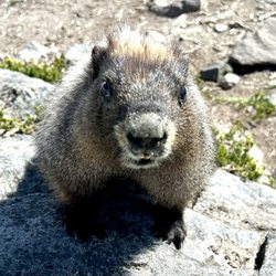
Reviews With Photos

I have had an expedition on Mount Denali with RMI company. As a mountaineer with three successful 8000m peaks (Everest north face, Cho Oyu and Shisha Pangma), Kilimanjaro, Aconcagua and many successful training courses, here is my feedback regarding RMI experience in Denali expedition. The following feedback has been shared with Joe Horiskey and Jeff Martin and they have been informed in advance that the following feedback will be shared in public for future applicants who are interested to know about the quality of services by RMI. I have registered with RMI to join the expedition on Denali under leadership of Tyler Jones (TJ). Here is my feedback which are shown in the attached photos:

If you're looking for a safe and professional guide experience, look no further. RMI guides are experienced, safe, professional and trustworthy. If you want to learn skills or have a safe climbing experience, this is a solid choice. I have climbed with several different guide companies and RMI is definitely the best of the best. If you want to have a great experience, show up with solid training and fitness because that's the only thing you can do to prepare. These guides are honest about what to expect and how to safely travel through challenging terrain. I trust Dominic and his team with my life. As someone who provides anesthesia for a a living, I feel like this statement carries a unique austerity. Climbing with RMI is a safe choice and a no brainer. I would consider trusting them for guided expeditions and beyond.
")
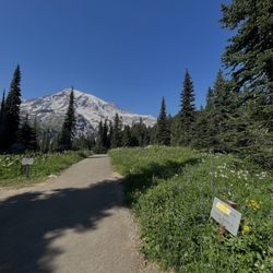
Four Day Summit Climb June 7 - 10, 2012 The RMI team was safe, professional, and provided an overall excellent experience doing one of the most dangerous, yet unforgettable activities you'll ever do! I had the pleasure of a summit attempt on Mt. Rainier last June doing the 4-day program. Leading up to the trip, I received several email reminders from RMI to keep up with my training and conditioning along with tips on how to be a successful mountaineer. Anytime I contacted them, they were extremely knowledge about anything from equipment to nutrition. Our first two days in Ashford were dedicated to preparation. They split us up into teams of 8 for both training and the ascent. We were taught basic climbing/stepping skills, use of an ice axe, slide prevention, packing and nutrition. This was also a time for physical fitness assessment. The actual climb to Camp Muir (base camp) is grueling. You get 10 minute breaks after each hour or so of hiking. It was easy to get frustrated and cranky, but it's not your guide's fault if you're not in shape! We ran into some serious head winds during our last stretch, but our guides made the right moves and got us to camp safely. After resting for several hours, we made our summit attempt in the early morning of our last day. Unfortunately, we did not complete our climb due to avalanche conditions. Our guides made the educated decision based on their survey of the mountain. At that point, I trusted them with almost anything. The RMI guides were awesome - they're like a mix of surfer dudes and back country woodsmen. They answered our questions and provided much needed encouragement. Safety was a consistent priority. I would use them again for sure.
!")
4 day Summit Climb of Mt. Rainier, June 1-4th, 2018. If you're on this Yelp page, you're most likely thinking of "attempting" to climb Mt. Rainier (key word is "attempting" - all dependent on your physical fitness, ability to acclimate, and most importantly weather). After reading some of the other reviews, let's preface this review by managing expectations on what to expect when you're attempting to climb a technically difficult mountain. 1) You are climbing a mountain. It has steep and difficult conditions/terrain. It is not a walk in the park, and therefore you should be in very good shape (they will warn you of this multiple times when you sign up, so that's on you if you aren't able to physically endure the pace). You will not make it if you just get off of the couch and expect to make it. 2) There is a reason for the "difficult" pace - you will be climbing with a group and you will be "roped-in" to each other. You must keep a certain distance from each other for safety reasons (must team-arrest if someone falls down the mountain/crevasse). You must keep a pace in order to make it up and back down the mountain at a reasonable time (higher risk of hypothermia, higher risk of danger if on the mountain longer). This "difficult" pace is absolutely reasonable if you have followed their instructions on how to prepare yourself physically. 3) You have likely booked this trip far in advance, and the dates are set. If the conditions are poor, the guides will attempt to summit as long as they believe it is safe to do so. On our first climbing day at 5pm up at Camp Muir, there was 60mph sustained winds and gusts reaching up to 92mph - instead of just calling it quits, the experienced guides (Zeb Blais and Mike Haugen) explained that microclimates occur often and the weather is unpredictable, and that we would attempt to wait out the storm (of which we did and the weather cleared up). If the storm had continued, we would have had to head back down due to unsafe conditions (and trust me, you do not want to attempt to walk over a snow bridge over a crevasse in high wind conditions). This is entirely reasonable and it would be foolish to attempt to continue in bad conditions. 4) If you have prepared physically in advance, you must prepare yourself mentally to understand that the winds/weather on the mountain will be the ultimate deciding factor if you will be able to summit or not. If mother nature decides to bring in heavy winds on the day of your attempt, then you most likely will not summit. Enjoy the views and trip along the way anyway, because you most likely learned a lot through the day-school! Our team guides were Zeb Blais, Mike Haugen, Dustin Wittmier, and "funny-guy" Greyson. All of them were professional, knowledgable, and personable. If it weren't for their kind interaction with us and their patience with us, we wouldn't have had such a great time. Zeb was our lead guide, and he told us exactly what we needed to do and when. Dustin and Greyson were absolutely fantastic. Both are very personable and explained to me and my buddies exactly what to expect, all-the-while with a big smile on their faces. They all took care of us and made sure we were prepared for the attempt. Could not have asked for anything more from the guides. Top notch quality and I hope the best for them in their future endeavors. Also, if they are recommending a certain layer to be put on/off at a certain point of the climb, you should listen to them. There were multiple times where I wanted to keep my parka on, but they recommended that we should take them off, and I'm really glad I did, otherwise I would've seriously overheated when we started moving. Any questions? I'll answer them to my best ability from my personal experience.

I got off a wait list for a Mt. Rainier summit at the end of August. Our guides were professional, prepared and realistic. Safety definitely was a top priority, and there was never a time on the climb that I felt uneasy. We had a great group, great weather and an amazing experience. The mountaineering school was a great warm-up and was perfect for teaching me alpine climbing basics. You will be successful on this guided climb if you arrive in good shape, have a realistic idea about your abilities and are up for a fun and great challenge.

Apparently, all the Rainier climbs are booked MONTHS in advance - I managed sneak in on a June, 4-day program (2-day lessons, 2-day summit) due to a cancellation. Efficiently organized, with guides both patient, but also clear and firm with expectations (considering safety for the team as a whole). And jalapeno burgers at the open-air grill next to the office/Whittaker Bunkhouse to end the day, yum.

Life changing expedition. Great guide crew. Smart and helpful. Climbing Mt. Rainier? Call on RMI to do it right. They have literally everything you will need to make it from parking lot to summit and back to the parking lot. I had a very good experience from the office, to the rentals and especially the guides. Andy, Mike and Pete were amazing guides that I hope I get to work with again because they made the trek to the summit possible by providing the safest route possible. I climbed Mt. Rainier with their expertise. Read about each guide service. You will find out that they are the best and most qualified guides.


1 year ago
Recently did a 5 day Rainier climb with RMI. Could not have asked for a better group of guides, both in their knowledge and skill expertise as well as their overall friendliness with all the climbers. It's a hard climb and they push you hard in order to stay safe and give everyone the best possible chance of success. We had an amazing summit climb! On the way down I had a medical emergency and the guides went above and beyond with extreme mountaineering skill to help get me down the mountain as quick as possible, likely saving my life. Amazing company to work with. Amazing climb! read more


1 year ago
It's a fraudulent organization that will take all your money without providing any guide services. Climb Rainer with a private group. I was told I would never be guided by RMI and they would keep all my. Manager Jeff said this to me in person and refused to state his last name. read more


1 year ago
1 year ago
2 years ago
I have had an expedition on Mount Denali with RMI company. As a mountaineer with three successful 8000m peaks (Everest north face, Cho Oyu and Shisha Pangma), Kilimanjaro, Aconcagua and many successful training courses, here is my feedback regarding RMI experience in Denali expedition. The following feedback has been shared with Joe Horiskey and Jeff Martin and they have been informed in advance that the following feedback will be shared in public for future applicants who are interested to know about the quality of services by RMI. I have registered with RMI to join the expedition on Denali under leadership of Tyler Jones (TJ). Here is my feedback which are shown in the attached photos: read more


1 year ago
3 years ago
If you're looking for a safe and professional guide experience, look no further. RMI guides are experienced, safe, professional and trustworthy. If you want to learn skills or have a safe climbing experience, this is a solid choice. I have climbed with several different guide companies and RMI is definitely the best of the best. If you want to have a great experience, show up with solid training and fitness because that's the only thing you can do to prepare. These guides are honest about what to expect and how to safely travel through challenging terrain. I trust Dominic and his team with my life. As someone who provides anesthesia for a a living, I feel like this statement carries a unique austerity. Climbing with RMI is a safe choice and a no brainer. I would consider trusting them for guided expeditions and beyond. read more
2 years ago
Four Day Summit Climb June 7 - 10, 2012 The RMI team was safe, professional, and provided an overall excellent experience doing one of the most dangerous, yet unforgettable activities you'll ever do! I had the pleasure of a summit attempt on Mt. Rainier last June doing the 4-day program. Leading up to the trip, I received several email reminders from RMI to keep up with my training and conditioning along with tips on how to be a successful mountaineer. Anytime I contacted them, they were extremely knowledge about anything from equipment to nutrition. Our first two days in Ashford were dedicated to preparation. They split us up into teams of 8 for both training and the ascent. We were taught basic climbing/stepping skills, use of an ice axe, slide prevention, packing and nutrition. This was also a time for physical fitness assessment. The actual climb to Camp Muir (base camp) is grueling. You get 10 minute breaks after each hour or so of hiking. It was easy to get frustrated and cranky, but it's not your guide's fault if you're not in shape! We ran into some serious head winds during our last stretch, but our guides made the right moves and got us to camp safely. After resting for several hours, we made our summit attempt in the early morning of our last day. Unfortunately, we did not complete our climb due to avalanche conditions. Our guides made the educated decision based on their survey of the mountain. At that point, I trusted them with almost anything. The RMI guides were awesome - they're like a mix of surfer dudes and back country woodsmen. They answered our questions and provided much needed encouragement. Safety was a consistent priority. I would use them again for sure. read more
 - Hiking Near Me - Ashford, Washington")
8 years ago
4 day Summit Climb of Mt. Rainier, June 1-4th, 2018. If you're on this Yelp page, you're most likely thinking of "attempting" to climb Mt. Rainier (key word is "attempting" - all dependent on your physical fitness, ability to acclimate, and most importantly weather). After reading some of the other reviews, let's preface this review by managing expectations on what to expect when you're attempting to climb a technically difficult mountain. 1) You are climbing a mountain. It has steep and difficult conditions/terrain. It is not a walk in the park, and therefore you should be in very good shape (they will warn you of this multiple times when you sign up, so that's on you if you aren't able to physically endure the pace). You will not make it if you just get off of the couch and expect to make it. 2) There is a reason for the "difficult" pace - you will be climbing with a group and you will be "roped-in" to each other. You must keep a certain distance from each other for safety reasons (must team-arrest if someone falls down the mountain/crevasse). You must keep a pace in order to make it up and back down the mountain at a reasonable time (higher risk of hypothermia, higher risk of danger if on the mountain longer). This "difficult" pace is absolutely reasonable if you have followed their instructions on how to prepare yourself physically. 3) You have likely booked this trip far in advance, and the dates are set. If the conditions are poor, the guides will attempt to summit as long as they believe it is safe to do so. On our first climbing day at 5pm up at Camp Muir, there was 60mph sustained winds and gusts reaching up to 92mph - instead of just calling it quits, the experienced guides (Zeb Blais and Mike Haugen) explained that microclimates occur often and the weather is unpredictable, and that we would attempt to wait out the storm (of which we did and the weather cleared up). If the storm had continued, we would have had to head back down due to unsafe conditions (and trust me, you do not want to attempt to walk over a snow bridge over a crevasse in high wind conditions). This is entirely reasonable and it would be foolish to attempt to continue in bad conditions. 4) If you have prepared physically in advance, you must prepare yourself mentally to understand that the winds/weather on the mountain will be the ultimate deciding factor if you will be able to summit or not. If mother nature decides to bring in heavy winds on the day of your attempt, then you most likely will not summit. Enjoy the views and trip along the way anyway, because you most likely learned a lot through the day-school! Our team guides were Zeb Blais, Mike Haugen, Dustin Wittmier, and "funny-guy" Greyson. All of them were professional, knowledgable, and personable. If it weren't for their kind interaction with us and their patience with us, we wouldn't have had such a great time. Zeb was our lead guide, and he told us exactly what we needed to do and when. Dustin and Greyson were absolutely fantastic. Both are very personable and explained to me and my buddies exactly what to expect, all-the-while with a big smile on their faces. They all took care of us and made sure we were prepared for the attempt. Could not have asked for anything more from the guides. Top notch quality and I hope the best for them in their future endeavors. Also, if they are recommending a certain layer to be put on/off at a certain point of the climb, you should listen to them. There were multiple times where I wanted to keep my parka on, but they recommended that we should take them off, and I'm really glad I did, otherwise I would've seriously overheated when we started moving. Any questions? I'll answer them to my best ability from my personal experience. read more
! - Hiking Near Me - Ashford, Washington")


. Highly recommend them for their experience, positive attitude, patience, and their humor! - Hiking Near Me - Ashford, Washington")
. - Hiking Near Me - Ashford, Washington")
7 years ago
3 years ago
3 years ago
7 years ago
I got off a wait list for a Mt. Rainier summit at the end of August. Our guides were professional, prepared and realistic. Safety definitely was a top priority, and there was never a time on the climb that I felt uneasy. We had a great group, great weather and an amazing experience. The mountaineering school was a great warm-up and was perfect for teaching me alpine climbing basics. You will be successful on this guided climb if you arrive in good shape, have a realistic idea about your abilities and are up for a fun and great challenge. read more


15 years ago
Apparently, all the Rainier climbs are booked MONTHS in advance - I managed sneak in on a June, 4-day program (2-day lessons, 2-day summit) due to a cancellation. Efficiently organized, with guides both patient, but also clear and firm with expectations (considering safety for the team as a whole). And jalapeno burgers at the open-air grill next to the office/Whittaker Bunkhouse to end the day, yum. read more

 - Hiking Near Me - Ashford, Washington")
4 years ago
7 years ago
7 years ago
Life changing expedition. Great guide crew. Smart and helpful. Climbing Mt. Rainier? Call on RMI to do it right. They have literally everything you will need to make it from parking lot to summit and back to the parking lot. I had a very good experience from the office, to the rentals and especially the guides. Andy, Mike and Pete were amazing guides that I hope I get to work with again because they made the trek to the summit possible by providing the safest route possible. I climbed Mt. Rainier with their expertise. Read about each guide service. You will find out that they are the best and most qualified guides. read more


8 years ago
13 years ago
11 years ago
The store is has got some really cool stuff in it! The people working are super nice and personable. The prices are fair. There's souvenir stuff, like shirts etc for Mt. Rainier. There's a playground just outside of the shop and a rock climbing wall. Worth stopping in! read more

9 years ago
Great mountaineering school for novice and intermediate climbers. Instructors teach you everything you need to safely claim a mountain and 'climb' down (which is more dangerous that going up). For more advanced climbers, they offer private climbing, but I like climbing with a team of 6/8 climbers. You will have a good time, and a good experience. 4-star because they are located in a remote town with limited transportation service from Seattle. read more


6 years ago
8 years ago
7 years ago
17 years ago
13 years ago
11 years ago
9 years ago
Pete Van Deventer and Mike Uchal: Thanks so much for guiding us through the cities, hills and peaks of Russia. I don't know if our paths will cross again in this crazy world of mountaineering, but I know and pray you will continue to wonderfully and positively impact so many others along your journey, just as you have my life journey. Godspeed. Rainier Mountaineering Inc. (RMI) remains my favorite resource and service... and I'll continue to refer! read more

8 years ago
10 years ago
14 years ago
12 years ago
15 years ago
10 years ago
11 years ago
More info about RMI Expeditions
30027 Sr 706 E
Ashford, WA 98304
Directions
(888) 892-5462
Call Now
Visit Website
http://www.rmiguides.com
Hours
Outdoor Amenities
Other Amenities
From the Business
Ask the Community - RMI Expeditions
Review Highlights - RMI Expeditions
You might also consider


Why does Yelp recommend reviews?
RMI Expeditions - hiking - Updated July 2026
Best of Ashford
People found RMI Expeditions by searching for…
Sledding in Ashford, Washington
Bungee Workout in Ashford, Washington
Indoor Rock Climbing in Ashford, Washington
Ski Resorts in Ashford, Washington
Bungee Jumping in Ashford, Washington
Things to Do in Ashford, Washington
Hiking Trails in Ashford, Washington
Sunrise View in Ashford, Washington
View Points in Ashford, Washington
Campgrounds in Ashford, Washington
Attractions in Ashford, Washington
Scenic Views in Ashford, Washington
Distilleries in Ashford, Washington
Rest Area in Ashford, Washington
Beautiful Views in Ashford, Washington
Snow Play in Ashford, Washington
Lodging in Ashford, Washington
Waterfalls and Swimming Holes in Ashford, Washington
Rock Climbing Gyms in Ashford, Washington
Easy Hikes in Ashford, Washington
Tourist Attractions in Ashford, Washington
Trending Searches in Ashford, WA
Browse Articles
Browse Nearby
Browse Brands
Related Cost Guides
Related Searches in Ashford, WA
Affordable Airport Shuttles Available in Ashford, Washington
Best Dog Hiking Trails Around Ashford, Washington
Best Fishing Locations and Guides in Ashford, Washington
Best Places for Horseback Riding in Ashford, Washington
Best Rock Climbing Gyms to Try in Ashford, Washington
Best Sledding Spots and Fun in Ashford, Washington
Best Things to Do on a Rainy Day in Ashford, Washington
Book Engaging Historical Tours in Ashford, Washington
Book a Dinner Cruise Experience in Ashford, Washington
Book a Trolley Tour Experience in Ashford, Washington
Check Out Off Road Trails in Ashford, Washington
Discover Architectural Tours Available in Ashford, Washington
Discover Dog Friendly Trails to Explore in Ashford, Washington
Discover Fun Recreation Activities in Ashford, Washington
Discover Kid Friendly Hiking Trails in Ashford, Washington
Discover Kids Indoor Play Area Venues in Ashford, Washington
Discover Popular Ropes Course Options in Ashford, Washington
Discover Powerlifting Gym Near Ashford, Washington
Discover Rock Climbing Walls in Ashford, Washington
Discover Scenic Mountain Bike Trails Near Ashford, Washington
Discover Top Boat Tours in Ashford, Washington for All Ages
Discover Top Yoga Options and Studios in Ashford, Washington
Discover a Hiking Trail in Ashford, Washington
Discover the Best Beaches in Ashford, Washington
Discover the Best Night Hike Trails in Ashford, Washington
Discover the Best Running Track in Ashford, Washington
Dog-Friendly Hikes With Dogs in Ashford, Washington
Enjoy Camping Adventures Around Ashford, Washington
Enjoy Hiking Adventures in Ashford, Washington
Enjoy Off Leash Dog Hikes in Ashford, Washington
Enjoy a Beautiful Waterfall Hike in Ashford, Washington
Enjoy the Best Bouldering Experiences in Ashford, Washington
Enjoy the Best Tubing Experiences in Ashford, Washington
Experience Stunning Sunset Views in Ashford, Washington
Experience Thrilling Helicopter Rides in Ashford, Washington
Experience a Unique Food Tour in Ashford, Washington
Explore Beautiful Parks and Green Spaces in Ashford, Washington
Explore Bike Rentals Throughout Ashford, Washington
Explore Easy Hikes Perfect for All in Ashford, Washington
Explore Family-Friendly Zoos and Wildlife in Ashford, Washington
Explore Fun Activities to Do in Ashford, Washington
Explore Jet Skis for Sale or Rent in Ashford, Washington
Explore Popular Campgrounds Near Ashford, Washington
Explore Popular Guided Tours in Ashford, Washington
Explore Popular Picnic Areas Around Ashford, Washington
Explore Popular RV Parks Around Ashford, Washington
Explore Popular Scenic Views Near Ashford, Washington