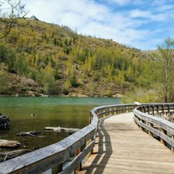
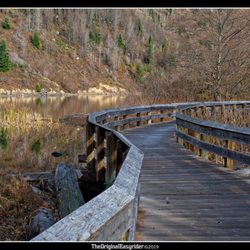
Pack Forest Fall Trail Photos


You might also consider
More like Pack Forest Fall Trail
Recommended Reviews - Pack Forest Fall Trail
Start your review...

11 years ago
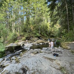
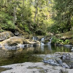
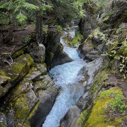
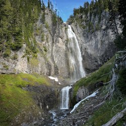
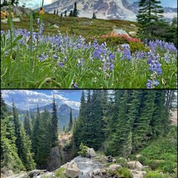
The map was a little confusing at first. We did the hiking trails and we're surprised how the paths are mainly kept up. We loved going out the falls. We didn't see the upper falls but the middle and the bottom. Was a little ways to figure how to get inside the waterfall but was awesome when we made it over :) but there was alot of trash at the bottom that needs to be cleaned like beer bottles. read more


7 years ago
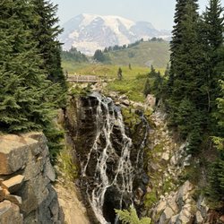
Really solid place to hike. Very clear trails with varying difficulty. We chose to go to the falls. The maps and markers were very clear which was great. The walk to the falls had good elevation and an amazing view. read more

More info about Pack Forest Fall Trail
9708-10128 453rd St E
Eatonville, WA 98328
Directions
Hours
Outdoor Amenities
You might also consider


Pack Forest Fall Trail - hiking - Updated July 2026
Best of Eatonville
People found Pack Forest Fall Trail by searching for…
Hiking Trails With Waterfalls in Eatonville, Washington
Things to Do in Eatonville, Washington
Waterfalls and Swimming Holes in Eatonville, Washington
Waterfalls in Eatonville, Washington
Walking Trails in Eatonville, Washington
Scenic View in Eatonville, Washington
Running Trails in Eatonville, Washington
Beautiful Views in Eatonville, Washington
Things to Do on a Rainy Day in Eatonville, Washington
View Points in Eatonville, Washington
Off Road Trails in Eatonville, Washington
Trails in Eatonville, Washington
Places to Visit in Eatonville, Washington
Nature Walks in Eatonville, Washington
Swimming Lakes in Eatonville, Washington
Lakes & Ponds in Eatonville, Washington
Views in Eatonville, Washington
To Do in Eatonville, Washington
River Swimming in Eatonville, Washington
Secret Spots in Eatonville, Washington
Forest in Eatonville, Washington
Easy Hiking Trails in Eatonville, Washington
Trending Searches in Eatonville, WA
4th Of July Fireworks near Pack Forest Fall Trail
Black Owned Nail Salons near Pack Forest Fall Trail
Boat Rental near Pack Forest Fall Trail
Cliff Jumping near Pack Forest Fall Trail
Day Trips near Pack Forest Fall Trail
Fireworks near Pack Forest Fall Trail
Jet Ski Rental near Pack Forest Fall Trail
Kayak Rental near Pack Forest Fall Trail
Lakes & Ponds near Pack Forest Fall Trail
Off Road Trails near Pack Forest Fall Trail
Outdoor Activities near Pack Forest Fall Trail
Parks For Picnics near Pack Forest Fall Trail
Places To Walk Around near Pack Forest Fall Trail
Public Pools near Pack Forest Fall Trail
Public Shower near Pack Forest Fall Trail
River Swimming near Pack Forest Fall Trail
Rock Quarry near Pack Forest Fall Trail
Scenic Night View near Pack Forest Fall Trail
Scenic Overlook near Pack Forest Fall Trail
Secluded Spots near Pack Forest Fall Trail
Soccer Store near Pack Forest Fall Trail
Splash Pad near Pack Forest Fall Trail
Strawberry Picking near Pack Forest Fall Trail
Sunrise View near Pack Forest Fall Trail
Swimming Holes near Pack Forest Fall Trail
Swimming Lakes near Pack Forest Fall Trail
Watch Sunset near Pack Forest Fall Trail
Browse Articles
Browse Nearby
Browse Brands
Related Searches in Eatonville, WA
Affordable Kayak Rental Services in Eatonville, Washington
Best Fishing Locations and Guides in Eatonville, Washington
Best Places for Horseback Riding in Eatonville, Washington
Best Sledding Spots and Fun in Eatonville, Washington
Best Waterfalls and Swimming Holes in Eatonville, Washington
Check Out Off Road Trails in Eatonville, Washington
Discover Dog Friendly Trails to Explore in Eatonville, Washington
Discover Scenic Mountain Bike Trails Near Eatonville, Washington
Discover Scenic Waterfall Spots in Eatonville, Washington
Discover Top Nature Parks to Visit in Eatonville, Washington
Discover Top State Parks to Visit in Eatonville, Washington
Discover a Hiking Trail in Eatonville, Washington
Discover the Best Night Hike Trails in Eatonville, Washington
Discover the Best Running Track in Eatonville, Washington
Dog-Friendly Hikes With Dogs in Eatonville, Washington
Enjoy Camping Adventures Around Eatonville, Washington
Enjoy Tent Camping Spots Around Eatonville, Washington
Enjoy a Beautiful Waterfall Hike in Eatonville, Washington
Enjoy the Best Walking Trails in Eatonville, Washington
Exciting Cliff Jumping Spots in Eatonville, Washington
Experience Thrilling White Water Rafting in Eatonville, Washington
Explore Beautiful Parks and Green Spaces in Eatonville, Washington
Explore Easy Hikes Perfect for All in Eatonville, Washington
Explore Fun Activities to Do in Eatonville, Washington
Explore Popular Campgrounds Near Eatonville, Washington
Explore Popular Scenic Overlook Points in Eatonville, Washington
Explore Scenic Lakes to Visit in Eatonville, Washington
Explore the Best Swimming Holes Around Eatonville, Washington
Explore the Best Trail Options in Eatonville, Washington
Family Friendly Hiking With Kids in Eatonville, Washington
Find Beautiful Views in Eatonville, Washington
Find Fun Kids Activities Outdoor in Eatonville, Washington
Find Popular Ziplining Spots Around Eatonville, Washington
Find the Best Parks for Picnics in Eatonville, Washington
Find the Best Playgrounds to Visit in Eatonville, Washington
Find the Best Scenic View Locations in Eatonville, Washington
Great Places to Walk in Eatonville, Washington
Hiking Trails With Waterfalls in Eatonville, Washington
Off Leash Dog Hiking Trails in Eatonville, Washington
Plan a Scenic Drive Route Near Eatonville, Washington
Popular Fishing Spots to Explore in Eatonville, Washington
Popular Picnic Spots to Visit in Eatonville, Washington
Popular Things to See in Eatonville, Washington
Safe River Swimming Areas in Eatonville, Washington
Safe and Fun Parks for Kids in Eatonville, Washington
Top Climbing Spots and Gyms in Eatonville, Washington
Top Running Trails to Explore in Eatonville, Washington
Top Things to Do With Kids in Eatonville, Washington
Walk Dog Friendly Hiking Trails in Eatonville, Washington
Walk the Best Paved Walking Trails in Eatonville, Washington