Myrtle Falls Photos


More like Myrtle Falls
Recommended Reviews - Myrtle Falls
Start your review...

Reviews With Photos

Myrtle Falls is a short walk from Jackson Visitor Center and is just picturesque. It's a 70 foot waterfall with the majestic Mount Rainier in the background. It's one of the best attractions in the park in terms of effort-to-reward ratio. I can see why it's one of the most popular and most photographed areas and you'll often see people with tripods taking pictures.


One of the bestttttt views of Mt Rainier ! Wowow . We were just amazed with this view ! The only issue is the space of this viewpoint ! It's pretty small and u r almost pushed out of ur spot , if u try to take 5-6 pics ! It's about a .5 mile walk from visitor center and it is worth it . There is a small walkway / step to the viewpoint . There are soooooo many people there trying to take a pic . Yeah . It's toooooo crowded on weekends and summer days ! It's still worth the view . Beautiful view of the falls with Rainier at the background . Tough to take strollers ! Loved it overall

Myrtle was on my list of sites to see while visiting the park for the first time. What I hadn't realized was that the Paradise area would be packed to the gils, as roads from there were already closed for the year. After battling for a parking spot we fought the ice rink of stairs that was to lead from the lot to the falls. The path to the falls was gorgeous, and of course crowded. With so many site seekers converged in the area, it was hard to get onto the bridge at the top, I had to wiggle past numerous tri-pods. To be expected I suppose, as Myrtle Falls has a stunning setting with direct views of the snowy peak above. I carefully traversed the icy stairs down to the viewing area, but not carefully enough I guess, as even though I was holding the cable I still went down hard. But, I was most of the way down and wanted my bruises to not be in vain, so I got up and finished my course. Glad I did, the view from below is amazing...especially with the blanket of snow on the surrounding trees. Overall, I'd hold to Myrtle being a must-see in the park. As an avid falls hiker, it's not the most unique falls out there, or even within the park. It's the setting that makes it special. *Sorry my pics aren't great, wrong time of day for shadows!

*Summer Flashback* Located in the Paradise region of Mount Rainier National Park, Myrtle Falls is such a delight to enjoy before continuing on to explore trails up ahead. On a sunny day, if you're lucky, Mount Rainier will appear directly in the backdrop of the Falls, making for an extremely picturesque shot. Although the mountain hid behind the clouds on the day I visited, I was still captivated by the entire scene. The Myrtle Falls viewpoint is accessible down a well-defined but steep set of steps covered with sand and some rocks. Although common sense, be sure to wear shoes with good traction to prevent sliding on the surface. While the lookout area is small and gets fairly crowded with visitors constantly rotating in and out, it provides the perfect place to snap some beautiful photos. Now for my favorite area of the park! Back on the main path in the same general area is a bridge which passes directly over a stream of water that feeds Myrtle Falls. There is something so serene about standing on the bridge, listening to the trickling water and appreciating the sight of the green hills that lead your gaze up to Mount Rainier. Spend a couple minutes here to take it all in...the views can't be beat!

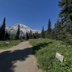
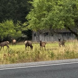
Beautiful, quick trail in Mount Rainer National Park. You can easily access it from the visitors center. It's a little bit of an incline but it's not hard. There are stopping points along the way for anyone that needs a quick resting spot. I was also very close to a deer walking on the path. The wildflowers along the way were absolutely stunning!

11 months ago
The trail to reach Myrtle falls is pretty easy/short (a little less than a mile) and BOY are the views stunning. The actual view of Myrtle facing Mt. Rainier is kind of the "poster child" picture for Mt. Rainier at least that I saw online so that was fun when I realized! A crowd definitely does gather right in front of the falls so don't be surprised, you may have to wait/ask folks to shift around if you want to get a nice photo. It's worth it though! Overall if you're visiting the Paradise part of Mt. Rainier, this is such an easy spot to get to that you absolutely should not miss. The whole trail path is paved. read more


This is one of the most photographed areas in Mount Rainier National Park. The view of Myrtle Falls with Mount Rainier in the background is one of the most stunning viewpoints in the whole park. Myrtle Falls is located in the Paradise area and is a short walk from the parking lot on the Skyline loop trail. The trail is moderately challenging and is on paved asphalt. This waterfall tumbles 72 feet into a rugged gorge, There is a viewing area off to the side that allows you to take photos of Myrtle Falls with Mount Rainier directly behind it. Just know that it can get crowded in this small area. There may also be professional photographers in this area taking photos with a tripod. There is a bridge over Myrtle Falls that allows you to see it from above. I highly recommend doing the full Skyline loop trail if you have time. It's a great hike. The Paradise area is closed during the winter season. read more


Absolutely beautiful stop. You look at pictures and postcards, and the picture looks more colorful and intense than in person. Myrtle Falls, however, is one of those places that is prettier and more impressive in person. Words (and even my picture) will not do it justice. A quick, easy 0.5 mile walk from the Paradise visitor center (on the Skyline Loop), it is easily accessible. If you don't have much time here, this is definitely a stop you should incorporate and will be quick. Parking is super easy at the visitor center at the start of the hike. An easily accessible, quick point of beauty in Mt Rainier National Park. read more

Myrtle Falls is a short walk from Jackson Visitor Center and is just picturesque. It's a 70 foot waterfall with the majestic Mount Rainier in the background. It's one of the best attractions in the park in terms of effort-to-reward ratio. I can see why it's one of the most popular and most photographed areas and you'll often see people with tripods taking pictures. read more


One of the bestttttt views of Mt Rainier ! Wowow . We were just amazed with this view ! The only issue is the space of this viewpoint ! It's pretty small and u r almost pushed out of ur spot , if u try to take 5-6 pics ! It's about a .5 mile walk from visitor center and it is worth it . There is a small walkway / step to the viewpoint . There are soooooo many people there trying to take a pic . Yeah . It's toooooo crowded on weekends and summer days ! It's still worth the view . Beautiful view of the falls with Rainier at the background . Tough to take strollers ! Loved it overall read more


Myrtle was on my list of sites to see while visiting the park for the first time. What I hadn't realized was that the Paradise area would be packed to the gils, as roads from there were already closed for the year. After battling for a parking spot we fought the ice rink of stairs that was to lead from the lot to the falls. The path to the falls was gorgeous, and of course crowded. With so many site seekers converged in the area, it was hard to get onto the bridge at the top, I had to wiggle past numerous tri-pods. To be expected I suppose, as Myrtle Falls has a stunning setting with direct views of the snowy peak above. I carefully traversed the icy stairs down to the viewing area, but not carefully enough I guess, as even though I was holding the cable I still went down hard. But, I was most of the way down and wanted my bruises to not be in vain, so I got up and finished my course. Glad I did, the view from below is amazing...especially with the blanket of snow on the surrounding trees. Overall, I'd hold to Myrtle being a must-see in the park. As an avid falls hiker, it's not the most unique falls out there, or even within the park. It's the setting that makes it special. *Sorry my pics aren't great, wrong time of day for shadows! read more


6 years ago
*Summer Flashback* Located in the Paradise region of Mount Rainier National Park, Myrtle Falls is such a delight to enjoy before continuing on to explore trails up ahead. On a sunny day, if you're lucky, Mount Rainier will appear directly in the backdrop of the Falls, making for an extremely picturesque shot. Although the mountain hid behind the clouds on the day I visited, I was still captivated by the entire scene. The Myrtle Falls viewpoint is accessible down a well-defined but steep set of steps covered with sand and some rocks. Although common sense, be sure to wear shoes with good traction to prevent sliding on the surface. While the lookout area is small and gets fairly crowded with visitors constantly rotating in and out, it provides the perfect place to snap some beautiful photos. Now for my favorite area of the park! Back on the main path in the same general area is a bridge which passes directly over a stream of water that feeds Myrtle Falls. There is something so serene about standing on the bridge, listening to the trickling water and appreciating the sight of the green hills that lead your gaze up to Mount Rainier. Spend a couple minutes here to take it all in...the views can't be beat! read more


3 years ago
Beautiful, quick trail in Mount Rainer National Park. You can easily access it from the visitors center. It's a little bit of an incline but it's not hard. There are stopping points along the way for anyone that needs a quick resting spot. I was also very close to a deer walking on the path. The wildflowers along the way were absolutely stunning! read more

5 years ago
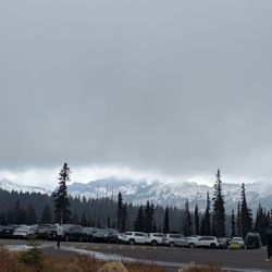
Went on 10/16/21 around 4pm and was surprised to see snow on the trail. Some parts are slippery. Recommend to wear traction cleats so you don't slip. Alot of people on trail were not prepared. We were helping each other down the steps. But overall, fun to see snow at this time. Not much view of the falls since covered in snow. read more


More info about Myrtle Falls
Ask the Community - Myrtle Falls
Review Highlights - Myrtle Falls


Myrtle Falls - hiking - Updated July 2026
Best of Ashford
People found Myrtle Falls by searching for…
Hiking Trails With Waterfalls in Ashford, Washington
Attractions in Ashford, Washington
Scenic View in Ashford, Washington
Waterfalls and Swimming Holes in Ashford, Washington
Photo Spots in Ashford, Washington
Things to Do in Ashford, Washington
River Swimming in Ashford, Washington
Star Gazing in Ashford, Washington
Lookout Points in Ashford, Washington
Playgrounds in Ashford, Washington
Sunrise View in Ashford, Washington
Watch Sunset in Ashford, Washington
Off Road Trails in Ashford, Washington
Sledding Hills in Ashford, Washington
National Parks in Ashford, Washington
Easy Hikes in Ashford, Washington
Visitor Centers in Ashford, Washington
Snow Play in Ashford, Washington
Walking Trails in Ashford, Washington
Sunset View in Ashford, Washington
Dog Friendly Hiking Trails in Ashford, Washington
Trending Searches in Ashford, WA
Browse Articles
Browse Nearby
BEST of Ashford, Washington Restaurants near Myrtle Falls
BEST of Ashford, Washington Things to Do near Myrtle Falls
BEST of Ashford, Washington Lakes near Myrtle Falls
BEST of Ashford, Washington Hot Springs near Myrtle Falls
BEST of Ashford, Washington Coffee near Myrtle Falls
BEST of Ashford, Washington Breakfast near Myrtle Falls
BEST of Ashford, Washington Lodging near Myrtle Falls
Browse Brands
Related Searches in Ashford, WA
Best Fishing Locations and Guides in Ashford, Washington
Best Off Leash Dog Parks in Ashford, Washington
Best Parks for Parties and Events in Ashford, Washington
Best Places for Horseback Riding in Ashford, Washington
Best Sledding Spots and Fun in Ashford, Washington
Best Spots for Star Gazing in Ashford, Washington
Best Water Parks for Kids in Ashford, Washington
Check Out Great Playgrounds in Ashford, Washington
Check Out Off Road Trails in Ashford, Washington
Discover Baseball Fields Around Ashford, Washington
Discover Fun Toddler Parks in Ashford, Washington for Your Little One
Discover Popular Bike Trails in Ashford, Washington
Discover Scenic Mountain Bike Trails Near Ashford, Washington
Discover Soccer Fields in Ashford, Washington Near You
Discover Top Nature Parks to Visit in Ashford, Washington
Discover a Hiking Trail in Ashford, Washington
Discover the Best Beaches in Ashford, Washington
Discover the Best Night Hike Trails in Ashford, Washington
Dog-Friendly Hikes With Dogs in Ashford, Washington
Effective Stairs Workout Spots in Ashford, Washington
Enjoy Camping Adventures Around Ashford, Washington
Enjoy Tent Camping Spots Around Ashford, Washington
Enjoy a Beautiful Waterfall Hike in Ashford, Washington
Enjoy the Best Night View Spots in Ashford, Washington
Enjoy the Best Tubing Experiences in Ashford, Washington
Enjoy the Best Walking Trails in Ashford, Washington
Exciting Cliff Jumping Spots in Ashford, Washington
Explore Beautiful Parks and Green Spaces in Ashford, Washington
Explore Bike Rentals Throughout Ashford, Washington
Explore Easy Hikes Perfect for All in Ashford, Washington
Explore Family-Friendly Zoos and Wildlife in Ashford, Washington
Explore Free Picnic Areas Around Ashford, Washington
Explore Fun Activities to Do in Ashford, Washington
Explore Parks With Pull Up Bars in Ashford, Washington
Explore Popular Campgrounds Near Ashford, Washington
Explore Popular Picnic Areas Around Ashford, Washington
Explore Popular RV Parks Around Ashford, Washington
Explore Popular Scenic Overlook Points in Ashford, Washington
Explore Popular Scenic Views Near Ashford, Washington
Explore Scenic Lakes to Visit in Ashford, Washington
Explore Top Dog Parks in Ashford, Washington Near You
Explore Top Gyms in Ashford, Washington Now
Family Friendly Hiking With Kids in Ashford, Washington
Find Beautiful Views in Ashford, Washington
Find Parks and Recreation Activities in Ashford, Washington
Find Top Dog Friendly Parks to Visit in Ashford, Washington
Find Top Skate Parks in Ashford, Washington for All Skill Levels
Find a Park With BBQ Pits in Ashford, Washington