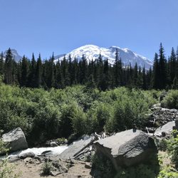
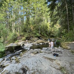
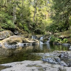
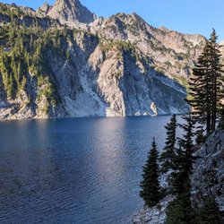
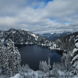
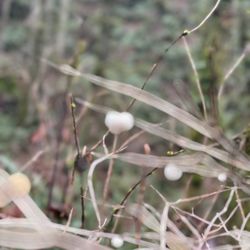
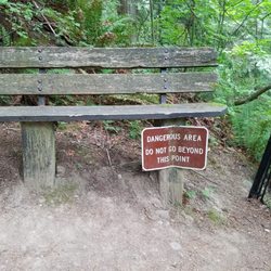
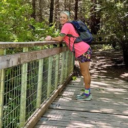
Cancel

    Open app

    Search

    Carbon River

    4.0 (1 review)

    Carbon River Photos

    You might also consider

    Recommended Reviews - Carbon River

    Your trust is our priority, so businesses can't pay to alter or remove their reviews. Learn more about reviews.
    Yelp app icon
    Browse more easily on the app
    Review Feed Illustration

    6 years ago

    Helpful 15
    Thanks 0
    Love this 16
    Oh no 0

    You might also consider

    Verify this business for free

    People searched for Hiking 397 times last month within 15 miles of this business.

    Verify this business

    Melmont Ghost Town - Recked car

    Melmont Ghost Town

    4.5(4 reviews)
    4.0 mi

    The best kept secret in pierce county. Finding parking will be difficult on a nice day. We parked…read morenear the bridge but others will park near Fairfax trail. It is about A 2 to 5 mile loop. So if you were to do a round-trip it could be up to 4 to 10. Well you walk around you'll see beautiful foliage, rivers, trees, and scary abandoned ghost town relics of buildings. There are some who criticize this nonexistent town but if you have some patience you will see a lot of the structures. Or even the foundations of them. It is very dog friendly. However there is no water for them so please bring your own. The ground is not very smooth so be careful of their paws. There are no garbage cans so pack it out. There are many locals hiking and walking. They are very friendly.

    The bestie and I decided to take a hike with my two dogs. This place popped up on a search. We're…read morein no way professional hikers and this hike made us both nervous a few times. We drove over a one lane bridge and then parked on the side where we saw other cars. Once we got out the car we couldn't tell where the actual hike started. Then we see a small sign that says it's north over the bridge. The one lane bridge? Yes. Yes this bridge. So off we go to walk across this high bridge with two dogs, also my youngest dog is a nut ball. Cars are driving past us but they're going slowly and we're staying all the way to the side. Once you cross the bridge there's a metal guardrail that you cross over. Then the trippy part starts. The actual hike is starts below the bridge. There's these crazy stones that I know they want to say are rock stairs but they are not. They are instead pieces of Earth that love to trip me. There is a metal guardrail to grab onto for balance and honestly there was a time when it held my entire body weight. And we have dogs on a leash to take down with us! What an adventure! I go down and have to convince the bestie to follow. She's convinced this is a bad idea now lol. It's not though, we toggle down and come to a nice hiking trail. We took a left and hiked for four miles before we turned around. I believe there's a town to hike to but we never found it. Sometimes the trail was too narrow and to high for my tastes but courage prevailed! It was all so beautiful! The trees, the water, the sky. I would go again...

    Photos
    Melmont Ghost Town - Old building

    Old building

    Melmont Ghost Town - River

    River

    Melmont Ghost Town - River down below

    See all

    River down below

    Glacier Basin Trail - Cute little fella

    Glacier Basin Trail

    5.0(2 reviews)
    14.8 mi

    The Glacier Basin Trail is utterly magical in every sense of the word. I must have taken hundreds…read moreof pictures and several videos while hiking this trail. This hike has everything that your little heart could ever desire! A forest full of giant trees. Vibrantly green shrubs. Waterfalls at practically each turn. Majestic views of not only the snow covered mountains, but the gorgeous aqua hues of the White River down below. The rushing river running parallel. Rampant wildlife. Colorful wildflowers. Inclines and elevation galore. I mean, shall I go on?! Just stunning. Glacier Basin is located near the White River entrance of Mount Rainier National Park. The trail begins just behind the White River Campgrounds. It's starts off mildly inclining through a lush forest, but the incline picks up speed and continues to incline until you reach the camp. It's about roughly 9 miles and 2,000 feet of elevation in total if you add in the the detour to the Emmons Lorraine Trail. Do it! It will add another 1.5/2miles to the hike, BUT... this is where you'll find that incredible view of the Inter Fork White River. It's funny that it's called the "white river" because it's stunningly aqua from the top of Emmons Lorraine. The Emmons Lorraine trail is a turn off that's about a mile into the Glacier Basin Trail and includes a river crossing and a steep incline up a narrow hill. It looks a bit intimidating, but it's really not. Just sit on your bum for the really gnarly parts coming down (at least that's what I did). Continuing on the Glacier Basin Trail, it's basically a straight shot up the hill for another 3 miles until you reach the top. There are a few spots with some switchbacks, but it's mostly a ridge-like trail. AllTrails has rated this hike as moderate, but it's definitely on the harder side of moderate if not difficult. What makes this hike so enjoyable though is the fact that there's so much scenery. Every time I took a break, I was either greeted by a beautiful mini waterfall or vibrant wildflowers. The views are very motivating and it keeps you going. Once you reach Glacier Basin Camp, you'll be met with the most stunning views of snow covered Mount Rainier and the rushing waters of the White River right next to it. This hike took me about 5 hours in total to complete (including breaks, lunch, and detours). It's definitely a day hike, so bring enough food and water to keep yourself nourished. Also, make sure you have some really comfortable hiking shoes/boots and hiking poles for the way down if you have bad knees. Coming down can be just as tough as hiking up because of the steepish downhill for 3 miles straight. This one is definitely going in the books as one of my favorite National Park hikes and my favorite Washington state hike thus far. If you're looking for a challenge and a great way to see the beauty of Mount Rainier National Park, Glacier Basin Trail is a great option.

    As a Seattle native, I can say that this is my favorite hike I've ever been on. The hike has a fork…read moreabout a mile in. If you fork left, there is a relatively short (~30 min) but steep trail that leads to the glacier basin. The water is a bright teal with mountains in the background, one of the best views I've ever seen. My friends and I went swimming in the basin, which was very cold but also very fun. If you stay on the main trail, it is an additional 6 miles that is moderate-difficult and took about 3 hours to get up. At the top, there is a really pretty meadow and campground. You will need a Mt. Ranier National Park pass ($50 annual or $30/week) to enter. I went on a weekday in the morning and had no trouble finding parking. The main trail was quite empty, but the left fork had a couple other groups. However, we more or less had the place to ourselves. Overall, 10/10 would reccomend!

    Photos
    Glacier Basin Trail
    Glacier Basin Trail - Stunning

    Stunning

    Glacier Basin Trail - Beautiful

    See all

    Beautiful

    Little Mashel Falls - It was a good hike! Definitely worth the view!

    Little Mashel Falls

    4.6(39 reviews)
    17.2 mi

    I'm on a mission to stay active during this pregnancy, and have been hiking every Saturday morning…read morefor the last month or so. Last Saturday we went to Little Mashel Falls, and it's the first "new" hike I've done in a while (one that I haven't done before). The information on AllTrails & WTA is kind of confusing and daunting to follow regarding parking, so let me make it easy for you - PARK AT THE BUD BLANCHER TRAIL. It directly takes you to the falls trailhead, you don't have to be out of the lot by 2:30 (it's open til dusk) and it's right off a main road so you're very close to civilization and not in the middle of a forest or random highway. You can easily GPS Bud Blancher Trail by name and have no issues. There is a portable bathroom at the trailhead that is clean & maintained regularly, so if you really need to go, it's not the worst. This trail is fairly easy. There were a few times that my heart got pumping, but overall it was a great morning workout. I didn't hike to the Upper Falls as I've heard the views weren't that great. I did the Middle & Lower falls. The lower falls is a steep descent and coming up is probably the most incline you'll deal with the entire hike. Middle Falls is very easy to get to but be VERY careful on all the big rocks as they are very slippery. We had someone in our group fall (they're okay) and I slipped a few times myself. That being said, it's gorgeous and you can go underneath/behind the falls for a deafening experience if you so desire! Highly recommend this trail. Dog-friendly, kid-friendly (I'd say 6 and up), and great for beginners.

    We really enjoyed exploring Middle Mashell Falls. We learned a lot by reading previous posts…read more Nicely maintained. Pet friendly. Next time we will pack a picnic & stay longer!! There is a bit of an incline before you get to the falls. Signage is very small & easy to miss on your first visit. We parked at Bud Blancher Trailhead

    Photos
    Little Mashel Falls
    Little Mashel Falls
    Little Mashel Falls - This photo was taken approx 2 minutes (5:45 pm) before our headlamps showed the glint of the cat's eyes and we fired

    See all

    This photo was taken approx 2 minutes (5:45 pm) before our headlamps showed the glint of the cat's eyes and we fired

    Mud Mountain Dam - You're basically looking at it!

    Mud Mountain Dam

    4.5(2 reviews)
    16.1 mi

    Way, way better than I expected!!…read more Every time I go to Mt Rainier I pass the sign for Mud Mountain Dam, and every time I chuckle at myself that people would want to go there because it sounds super lame. WELL! I had energy left after my Mt Rainier hike, so I decided why not? It's on the way home and the worst thing that happens is I never come back. I was always under the impression that you had to hike in, but after following the road a ways I came to a developed parking lot and what appeared to be a look out point. Nice looking, new playground for the kiddos. Bathrooms are available and a huge props to the people that maintain them!! The buildings were older and a bit run down, but the facilities were *clean*! Even smelled nice, I was really shocked! Lookout point is right off of the parking lot and is ADA accessible. There are several educational signs along the way and in the lookout shelter and some really lovely views! There's also a trail. Pretty short, 1/2 mile? Switchbacks all the way. There's a new chain-link fence for safety and the trail ends at a little lookout point that gets you a lovely view of the dam. Most definitely not worth a special trip, but if it's already on the way it's not a bad idea to stop by and check it out!

    Presently under construction, for the play ground. Once completed though, it looks like it will be…read morefun for little ones. The trail is still open. Beautiful walk. I do not recommend using a bike or a stroller on the trail, lots of cliffs without fencing. A very muddy beautiful walk.

    Photos
    Mud Mountain Dam - January 10, 2021 -- The road going into the dam is currently closed due to Covid restrictions.

    January 10, 2021 -- The road going into the dam is currently closed due to Covid restrictions.

    Mud Mountain Dam - Several switchbacks on the trail

    Several switchbacks on the trail

    Mud Mountain Dam

    See all

    Carbon River - hiking - Updated May 2026

    Loading...
    Loading...
    Loading...