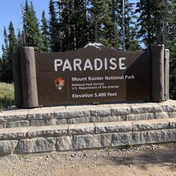
Mt Rainier Photos


You might also consider
More like Mt Rainier
Recommended Reviews - Mt Rainier
Start your review...

Reviews With Photos


People who love deserts the most might say they don't like Mt. Ranier, but they're probably the only people who don't. Whether you're driving through, hiking the trails, or spending time deep in the interior, you'll find plenty of breathtaking spots. The park is accessible for all experience levels, and you can stroll the nicely paved paths to enjoy the views or do some serious trekking. Come early in the day to avoid the crazy crowds and often sketchy weather. It's on the park passport list, so grab your stamp and don't miss one of the Crown Jewels in the Pacific Northwest.

Wherever you stand in Washington State you can see the big and bold Mt. Rainier. After years of looking at the mountain from Seattle today I made the trip and it was more than I could have imagined. If you like the outdoors, nature, camping, hiking. Mountain climbing, science, elk, etc., you must add this adventure to your to do list. Tips: - depart early to arrive early to the park. - try your best to not go on a weekend, it will be crowded. (Mid-week is best) - prior to departure check the roads, you can call ahead to find out about road and entrance closures, etc. - make sure you meet a ranger at the visitor center, they will educate you on everything you need to know and they are so patient. (If you have kids with you take advantage of the junior ranger program) - dress for the occasion!!!! - check out more tips on nps.gov Would I go again? Already planning it. I need to hike further and climb the mountain. Should you go? Absolutely!!


One of the most beautiful and majestic mountains I've ever been to. Every road you take has beautiful views, the rivers, creeks, waterfalls, the trees!! We came to explore during the fall because I've seen what beautiful colors it can bring and I have not been disappointed one bit! This is a must, if you live in the west coast. You must take the Paradise trails road to see all the waterfalls. You will not regret it!


Beautiful mountain and the view from Paradise and the Paradise Lodge is phenomenal. Friendly people and everywhere you look it really is paradise! Wish it wasn't so snowy and slushy & It were easier to walk on the trails There is a visitor center park ranger standing in front and maps. Disappointed that there aren't range of programs because of Covid. Many of the trails are closed because of avalanches and poor conditions because of the snow

Mount Rainier is unquestionably awe-inspiring! As you drive into the park, it's impossible not to be astonished by the sheer enormity of the mountain. When I first entered the park, I hiked to Silver Falls and enjoyed seeing the gorgeous waterfall. At the Paradise Visitor Center, I walked a few miles toward Mount Rainier and enjoyed playing in the snow and seeing the beautiful wildflowers.

Stellar spot: Jewel of the Great Northwest! Trails: The National Park service gives you a decent map on the way in. It's great to see the big picture. Pro tip: Download the All Trails app before you go and select 2 hikes that match your ability, energy, and time. That way, if you run into snow or an impasse on the first, you can flip around and try the second option. I have had AT&T cell service almost the whole way, but don't count on it. -Great views of the mountain as you climb? Check! -Ridges and valleys of lush green rippling out in every direction? Oh yeah! -Wonderful gift shop full of practical, tasteful souvenirs and snacks? Yep and yum! -Plenty of restrooms? Yes. -Adequate parking? Well....that depends on how early you arrive. -Lines getting into the park? Yep, but also depends on how early you get there. -Snow impeding trails? Sometimes late into the spring and early in the fall. Check with other hikers. People have been super friendly and helpful every time we've gone. Tip: Arrive as early as you can and bring a good camera, hiking boots, food and water!!


Visited Mt. Rainier National Park and hiked the Skyline Trail (5.6 miles)--absolutely worth it. The trail offers breathtaking views of Mt. Rainier at almost every turn. We spotted plenty of squirrels that come surprisingly close looking for food. The trail is well-maintained, and there's even a restroom along the way. Paradise Inn Hotel nearby has a café and is very visitor-friendly. They provide free restroom access and water refills, which is super convenient. The Visitor Center staff are helpful and share great tips for exploring. Over weekends, they even set up telescopes for stargazing--a unique experience. Perfect mix of hiking, nature, and amenities for all types of travelers. Highly recommend the Skyline Trail for anyone visiting Mt. Rainier. read more


11 months ago
An absolutely incredible, 10/5 national park. The entire place is just stunning, and I felt so lucky because I came right at the beginning of July - the first day I went was a Thursday (7/3/25) and I went to Paradise for skyline trail. The second day was Friday ofc (7/4/25) and it was the first day that Sunrise opened for the summer so we got to go! You need a reservation as of 7/11/25 for sunrise corridor after 7am, so bear that in mind. While I could've spent WAYYY more time in this park, the skyline loop to panorama point was my major goal and I did that. I met a marmot along the way whom I named Margo, she is my spirit guide and good friend. I saw lots of chipmunks and other marmots along the way too, plus an eagle! It is a STUNNING trail, but even early July still has leftover snow slush so come prepared and be safe! The park is pretty big actually, and there are amazing things to do on all sides so I couldn't make it to Tolmie peak (still closed) or Naches loop trail (too far/off schedule for us). Would love to go back to do these trails. Overall, I just love Mt. Rainier. The National parks of Washington in general hold a very special place in my heart, and Rainier in particular just feels so iconic and special. Parks like this one truly are some of the greatest things about America. It makes me so happy and proud that their home is my home, and that they are available for everyone to enjoy. read more


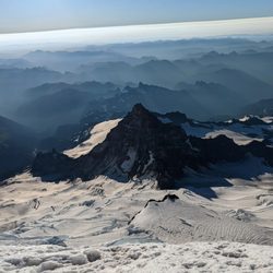
I have flown over this mountain more times than I can think of when I visited my Dad in Seattle. It is an amazing site to see from a plane when it peeks through the clouds. My Dad never had any interest in driving over and seeing it up close, so I planned my own trip after he moved away. Mount Rainier is located about 60 miles southeast of Seattle in Mount Rainier National Park. You can see Mount Rainier from a distance in both Seattle and Portland. Mount Rainier is a large active stratovolcano in the Cascade Range in Washington State. It is the tallest mountain in Washington. Mount Rainier's summit has an elevation of 14,410 feet and is covered in glacial ice. It also has two volcanic craters on its summit. Mount Rainier most likely will erupt in the near future which will threaten many nearby homes and businesses in the surrounding area. The national park itself is visited annually by many tourists and mountain climbers. I was able to drive around and photograph Mount Rainier from many different angles. I really wanted to get up and close to it. So I hiked the 5.5 mile Skyline Loop Trail to the base of the mountain. What an incredible site it was to see this mountain up close. I saw a group of mountain climbers getting ready to climb to the summit while I was at the base. The trail itself is a great hike with all sorts of beautiful wildflowers, waterfalls and wildlife along the way. I highly recommend doing it. Mount Rainier National Park is a fun park to explore. There are many hiking trails and waterfalls that you can check out while driving around. Definitely spend some time in the park and at the visitor centers. There is a lot of information about the mountain that you can read in the exhibits. I did a three day trip to this national park and had a wonderful. read more


1 year ago
Our planned day to visit Mount Rainier fell on May 22nd, a day before all the park roads were scheduled to reopen. It was also cloudy, so we didn't get to see the Mountain. However, we did see numerous waterfalls on our ride to Paradise and visit the Paradise Inn. read more


People who love deserts the most might say they don't like Mt. Ranier, but they're probably the only people who don't. Whether you're driving through, hiking the trails, or spending time deep in the interior, you'll find plenty of breathtaking spots. The park is accessible for all experience levels, and you can stroll the nicely paved paths to enjoy the views or do some serious trekking. Come early in the day to avoid the crazy crowds and often sketchy weather. It's on the park passport list, so grab your stamp and don't miss one of the Crown Jewels in the Pacific Northwest. read more


Wherever you stand in Washington State you can see the big and bold Mt. Rainier. After years of looking at the mountain from Seattle today I made the trip and it was more than I could have imagined. If you like the outdoors, nature, camping, hiking. Mountain climbing, science, elk, etc., you must add this adventure to your to do list. Tips: - depart early to arrive early to the park. - try your best to not go on a weekend, it will be crowded. (Mid-week is best) - prior to departure check the roads, you can call ahead to find out about road and entrance closures, etc. - make sure you meet a ranger at the visitor center, they will educate you on everything you need to know and they are so patient. (If you have kids with you take advantage of the junior ranger program) - dress for the occasion!!!! - check out more tips on nps.gov Would I go again? Already planning it. I need to hike further and climb the mountain. Should you go? Absolutely!! read more


 - Climbing Near Me")


One of the most beautiful and majestic mountains I've ever been to. Every road you take has beautiful views, the rivers, creeks, waterfalls, the trees!! We came to explore during the fall because I've seen what beautiful colors it can bring and I have not been disappointed one bit! This is a must, if you live in the west coast. You must take the Paradise trails road to see all the waterfalls. You will not regret it! read more


Tis a magical place full of rock and water, and plenty of wood, and if you can make the trip then you surely should. Many new favorite hikes I did in this space, because they're steeply elevated in many a place. One day I'll summit Mighty Mount Rainier..but probably not this year. read more


Beautiful mountain and the view from Paradise and the Paradise Lodge is phenomenal. Friendly people and everywhere you look it really is paradise! Wish it wasn't so snowy and slushy & It were easier to walk on the trails There is a visitor center park ranger standing in front and maps. Disappointed that there aren't range of programs because of Covid. Many of the trails are closed because of avalanches and poor conditions because of the snow read more


Mount Rainier is unquestionably awe-inspiring! As you drive into the park, it's impossible not to be astonished by the sheer enormity of the mountain. When I first entered the park, I hiked to Silver Falls and enjoyed seeing the gorgeous waterfall. At the Paradise Visitor Center, I walked a few miles toward Mount Rainier and enjoyed playing in the snow and seeing the beautiful wildflowers. read more


What an absolute amazing park! An absolute must see. We hiked the wonderland trail in its entirety and it is so gorgeous out there. The bridges, the hills, the water falls all while circling mt rainier was a great hike. So much to see here. Great campgrounds. read more


Stellar spot: Jewel of the Great Northwest! Trails: The National Park service gives you a decent map on the way in. It's great to see the big picture. Pro tip: Download the All Trails app before you go and select 2 hikes that match your ability, energy, and time. That way, if you run into snow or an impasse on the first, you can flip around and try the second option. I have had AT&T cell service almost the whole way, but don't count on it. -Great views of the mountain as you climb? Check! -Ridges and valleys of lush green rippling out in every direction? Oh yeah! -Wonderful gift shop full of practical, tasteful souvenirs and snacks? Yep and yum! -Plenty of restrooms? Yes. -Adequate parking? Well....that depends on how early you arrive. -Lines getting into the park? Yep, but also depends on how early you get there. -Snow impeding trails? Sometimes late into the spring and early in the fall. Check with other hikers. People have been super friendly and helpful every time we've gone. Tip: Arrive as early as you can and bring a good camera, hiking boots, food and water!! read more

Oh my wow! Hiking here was pretty intense bit the view was just amazing. So breath taking. We drove three hours for a hike not know we had to pay about $25. Now know so, instead of just a day trip I will plan to stay there for a weekend like camping or stay somewhere nearby. read more

5 years ago
I love going to Mt Rainier. I took this picture of "reflection" in Paradise. WA State is so beautiful! I love going to the mountains. read more


More info about Mt Rainier
Ask the Community - Mt Rainier
Review Highlights - Mt Rainier
You might also consider


Why does Yelp recommend reviews?
3 reviews that are not currently recommended
The reviews below are not factored into the business's overall star rating.
2 years ago
7 months ago
Mt Rainier - climbing - Updated June 2026
Best of Paradise
People found Mt Rainier by searching for…
Sledding in Paradise, Washington
Hiking Trails With Waterfalls in Paradise, Washington
Snow Play in Paradise, Washington
Campgrounds in Paradise, Washington
Star Gazing in Paradise, Washington
Indoor Rock Climbing in Paradise, Washington
Beautiful Views in Paradise, Washington
Off Road Trails in Paradise, Washington
Stair Climbing in Paradise, Washington
Sunrise View in Paradise, Washington
Waterfalls and Swimming Holes in Paradise, Washington
Things to Do in Paradise, Washington
Visitor Centers in Paradise, Washington
Photo Spots in Paradise, Washington
Scenic View in Paradise, Washington
Climbing Gym in Paradise, Washington
Sledding Hill in Paradise, Washington
Tent Camping in Paradise, Washington
Scenic Restaurants in Paradise, Washington
Camping Sites in Paradise, Washington
Secret Spots in Paradise, Washington
Browse Nearby
BEST of Paradise, Washington Coffee near Mt Rainier
BEST of Paradise, Washington Things to Do near Mt Rainier
BEST of Paradise, Washington Hiking near Mt Rainier
BEST of Paradise, Washington Ziplining near Mt Rainier
BEST of Paradise, Washington Breakfast near Mt Rainier
BEST of Paradise, Washington Hot Springs near Mt Rainier
BEST of Paradise, Washington Restaurants near Mt Rainier