Naches Peak Loop Trail Photos


More like Naches Peak Loop Trail
Recommended Reviews - Naches Peak Loop Trail
Start your review...

This is a really good loop trail! Super easy and you feel very accomplished with all the different open areas to see. This is definitely one you can take your young children or grandparents with. It's not the same views as the skyline loop. Let's be honest you're just not gonna beat those views and photo spots. But it's a very enjoyable hike. read more


3 years ago
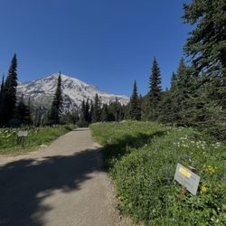
An absolutely gorgeous, not-too-difficult trail in the Mount Rainier area. We were lucky to come on a perfectly clear day, and had amazing views of Mount Rainier for about half of the loop. Cannot recommend this hike enough. As with most hikes in the Rainier area, it's better to come on a week day if possible to avoid the crowds and have more luck with parking. read more


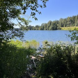
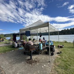
Quite the delightful trail located at the top of Chinook pass. We'd heard about it for some time and decided to check it out. It's roughly an hour up highway 410 near the top of the pass. There are three separate parking areas and a main one with a couple state park-esk bathrooms. Nice to have but your kids will comment on them and you'll breathe through your mouth. The hike is beautiful and not super strenuous. It's a little over 3 miles with some breath taking views and great spots to look around. About 15 minutes in was a nice little pond that the kids ran around. After you reach the half way point, there is a magnificent view of Rainier! The hike was good for our 3, 5 and 7 year olds. We had to watch the little dude closely as the path dropped off quickly, but overall he did great. Definitely some steeper spots but nothing super hard. This was an awesome activity for a weekend morning! Take snacks and water as it'll take a bit, but the experience was excellent and worth the trip! read more


More info about Naches Peak Loop Trail


Why does Yelp recommend reviews?
1 review that is not currently recommended
The reviews below are not factored into the business's overall star rating.
3 years ago
Naches Peak Loop Trail - hiking - Updated June 2026
Best of Ashford
People found Naches Peak Loop Trail by searching for…
Photo Spots in Ashford, Washington
Scenic View in Ashford, Washington
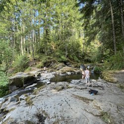
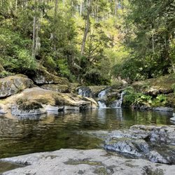
Hiking Trails With Waterfalls in Ashford, Washington
View Points in Ashford, Washington
Scenic Spots in Ashford, Washington
Sunrise View in Ashford, Washington
Things to Do in Ashford, Washington
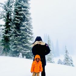
Snow Play in Ashford, Washington
Beautiful Views in Ashford, Washington
Picnic Spots in Ashford, Washington
Off Road Trails in Ashford, Washington
Sunrise Hike in Ashford, Washington
Picnic Areas in Ashford, Washington
Scenic Restaurants in Ashford, Washington
Rock Quarry in Ashford, Washington
Lookout Points in Ashford, Washington
Easy Hikes in Ashford, Washington
Secret Spots in Ashford, Washington
Walking Trails in Ashford, Washington
Hikes With Dogs in Ashford, Washington
Trending Searches in Ashford, WA
Fishing Spots near Naches Peak Loop Trail
Lakes near Naches Peak Loop Trail
Parks near Naches Peak Loop Trail
Pick Your Own Farms near Naches Peak Loop Trail
Public Shower near Naches Peak Loop Trail
River Swimming near Naches Peak Loop Trail
Splash Pad near Naches Peak Loop Trail
Swimming Holes near Naches Peak Loop Trail
Browse Articles
Browse Nearby
BEST of Ashford, Washington Restaurants near Naches Peak Loop Trail
BEST of Ashford, Washington Horseback Riding near Naches Peak Loop Trail
BEST of Ashford, Washington Coffee near Naches Peak Loop Trail
BEST of Ashford, Washington Breakfast near Naches Peak Loop Trail
BEST of Ashford, Washington Wineries near Naches Peak Loop Trail
BEST of Ashford, Washington Sledding near Naches Peak Loop Trail
BEST of Ashford, Washington Campgrounds near Naches Peak Loop Trail
BEST of Ashford, Washington Ski Resorts near Naches Peak Loop Trail
Browse Brands
Related Searches in Ashford, WA
Best Fishing Locations and Guides in Ashford, Washington
Best Places for Horseback Riding in Ashford, Washington
Best Sledding Spots and Fun in Ashford, Washington
Best Spots for Star Gazing in Ashford, Washington
Check Out Off Road Trails in Ashford, Washington
Discover Popular Bike Trails in Ashford, Washington
Discover Scenic Mountain Bike Trails Near Ashford, Washington
Discover Top Nature Parks to Visit in Ashford, Washington
Discover a Hiking Trail in Ashford, Washington
Discover the Best Night Hike Trails in Ashford, Washington
Dog-Friendly Hikes With Dogs in Ashford, Washington
Effective Stairs Workout Spots in Ashford, Washington
Enjoy Camping Adventures Around Ashford, Washington
Enjoy Tent Camping Spots Around Ashford, Washington
Enjoy a Beautiful Waterfall Hike in Ashford, Washington
Enjoy the Best Night View Spots in Ashford, Washington
Enjoy the Best Tubing Experiences in Ashford, Washington
Enjoy the Best Walking Trails in Ashford, Washington
Exciting Cliff Jumping Spots in Ashford, Washington
Explore Beautiful Parks and Green Spaces in Ashford, Washington
Explore Bike Rentals Throughout Ashford, Washington
Explore Easy Hikes Perfect for All in Ashford, Washington
Explore Family-Friendly Zoos and Wildlife in Ashford, Washington
Explore Fun Activities to Do in Ashford, Washington
Explore Popular Campgrounds Near Ashford, Washington
Explore Popular RV Parks Around Ashford, Washington
Explore Popular Scenic Overlook Points in Ashford, Washington
Explore Scenic Lakes to Visit in Ashford, Washington
Explore Top Dog Parks in Ashford, Washington Near You
Family Friendly Hiking With Kids in Ashford, Washington
Find Beautiful Views in Ashford, Washington
Find Parks and Recreation Activities in Ashford, Washington
Find Top Dog Friendly Parks to Visit in Ashford, Washington
Find Top Skate Parks in Ashford, Washington for All Skill Levels
Find the Best Parks for Picnics in Ashford, Washington
Find the Best Playgrounds to Visit in Ashford, Washington
Find the Best Swimming Pools in Ashford, Washington Today
Hiking Trails With Waterfalls in Ashford, Washington
Locate a Public Shower Facility in Ashford, Washington
Off Leash Dog Hiking Trails in Ashford, Washington
Perfect Spots to Watch Sunset in Ashford, Washington
Popular Kids Activities in Ashford, Washington
Popular Picnic Spots to Visit in Ashford, Washington
Popular Things to Do in Ashford, Washington
Safe River Swimming Areas in Ashford, Washington
See Top Fireworks Events in Ashford, Washington
Top Climbing Spots and Gyms in Ashford, Washington
Top Running Trails to Explore in Ashford, Washington