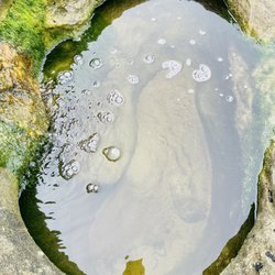
Sitton Peak Photos


You might also consider
More like Sitton Peak
Recommended Reviews - Sitton Peak
Start your review...

Reviews With Photos

Incredible hike! Start early especially in the summer!! Started at 7:15 am, luckily it was overcast and cool in the morning, but once it hit 10 am the sun started beating down...HOT!! There was a slight breeze coming through the valley, which was very inviting. This is a 10 mile out and back trail, approx 4 hour moving time. Allow some time to enjoy the peak, if it's not crowded. Unfortunately, it was crowded when we reached it. It is a gorgeous peak, with a 360° view of Cleveland National Forest. This trail is considered "hard" on alltrails, however I would place it as moderate, this trail is doable for all. I would not recommend bringing little humans on this trail, unless your little human is versed in hiking long distance and inclines. The last .5 miles of the trail, is the most grueling. The incline is steep, also watch out for loose boulders, rocks, and dirt. Take it slow and pace yourself. Wear comfortable hiking shoes/boots, use trekking poles, apply sunblock, and hydrate. Bring a lot of H2O, you'll need it. To be honest, the peak is worth every step!
Getting to the Sitton Peak trail is about a 5 mile hike from the Ortega Highway through the Bear Canyon trail. The short quarter mile hike up the mountain to Sitton Peak was a tough final challenge. This is not recommended for kids or anyone with mobility issues. On a hot day it's easy to overexert yourself and on a wet day ( as it was for me ) the first part can be pretty muddy and slippery. Once you get to the top, the view is AMAZING. On my visit I could see Santa Catalina Island. If you've made it as far the Sitton trailhead you might as well just hike it because the views are that good...Take your time and take breaks.. Tip - There are several unmarked trails going up and it's easy to go off trail. Don't worry, just keep going up.. Also look for trekking pole holes in the ground to see where other's have walked.

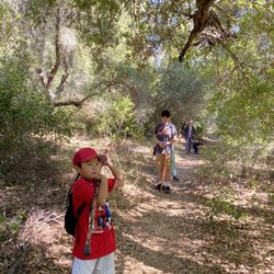
We did an early morning hike on Sunday (12/9/18) and reached the peak before sunrise...which was spectacular! Trailhead- you can use this address 34950 Ortega Hwy which is the candy store and the parking for the hike is directly across the street; don't forget to display your Adventure Pass for $5 or buy an annual pass at Big 5 for $30 and add a 2nd car pass for $5 and split the cost with a friend for only $17.50 if you hike a lot like me this is the best decision; the Bear Canyon Trailhead is located to the right of the candy store Trail- it was in surprisingly good shape even with all the recent rains and it is pretty wide and well marked until the last half of a mile to the peak; there are times when the trail has a connecting trail and you just want to opt to the right each time...this happens at 1.0 miles in, again at the 2 mile mark, and then at about 3.2 miles you get to a spot that I think is called "4 Corners" and you take a sharp right to leave the Bear Canyon trail to use the Sitton Peak Trail; the trail for the most part is moderately steep at times with some breaks of flat areas or decline and only gets hard once you have done 4.5 miles where you will need to take a narrow trail that will be on your right and this part is pretty steep at times where you will be using your arms to balance and support yourself and this part is difficult for about .4 miles until you reach the peak...just take this part slowly and you will be rewarded at the peak Peak- you will be rewarded with beautiful views to the west and east especially...we arrived shortly after 6 am since we started a little after 4am! It was a spectacular sunrise and we probably spent close to 45 mins at the top eating, drinking mimosas (we fancy hikers), and taking an abundance of pictures; there is a sign at the top with the name/elevation Details/Recommendations: my recording on AllTrails calculated it as 4.9 to the peak and 9.8 miles RT; it took us a little over 2 hrs to the top and about 1 hr 45 mins down with us spending about 45-60 mins at the top so I would say give yourself around 5 hrs to complete this; the elevation gain is about 2,100 ft and peak elevation is 3,273 ft; hiking poles might be helpful for the difficult half mile near the peak but can be done without; of course have hiking shoes, some water (1-2L), and some snacks, this hike is moderately difficult and anyone who hikes somewhat regularly or exercises a bit will be able to do this...because of the nearly 10 miles total young children might get fatigued

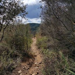
Relatively easy trail, 10 miles round trip. This trail is easily runable except for the .6 miles to the peak which is steep and washed out. Took me 3 hours from car to peak to car. There is no shade, and it does get a little confusing due to being over grown but once you start thinking is this the trail, a sign pops up. There is not much shade, a lot is exposed, bugs were coming out as I was descending. Not heavily trafficked at all I only saw one other person at mile 2 on the way out. Enjoy!

Enjoyed the hike with Meet Up today. We started at 7am--it was freezing cold!!! My first time on this trail--hike was tough but I made it to the peak!!! The trail gets narrow and rocky in various areas especially as you near thWear hiking shoes - NOT tennis shoes or sandals!My calories burn was over 1300 calories!!! Total steps over 13,000.

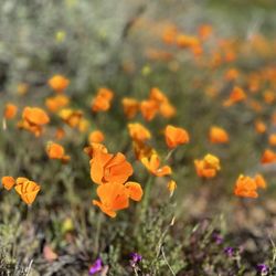
Sitton Peak stands at 3,273 feet tall and is one of the 7 peaks in the Santa Ana Mountain range. Located just off Ortega Highway 74 near Lake Elsinore, the 10-11 mile round-trip hike is a moderate to challenging experience for regular hikers. On average, the hike to Sitton Peak will take between 3.5-5.5 hours, depending on your athletic experience and amount of time spent enjoying the scenery. Enjoy a ceiling of trees during the first mile of the hike and copious wildflowers along the way. From the summit of Sitton Peak, savor lofty views of the Santa Ana Mountains.

Not bad for a 10 mile hike. Most of the hike is a slow and steady incline that we trucked through quickly and our butts were sore. Park across from the candy store, book it across the street and you will see the Bear Canyon Trailhead on the right. It's easy to spot. Sign in and then trek till you see the San Mateo Canyon Wilderness, about 1 mile or so. The trail is easy to find with white markers, mostly take the right. When you reach the 4 Corners, a very easy to spot flat area, take the right. The last white pole marker points you to Sitton Peak, also on the right and is on the right. It's very steep and I was glad to have my hiking boots. It was muddy the day we went so it felt safer actually since we were lodged in. The hiking boots were definitely helpful coming down! Anyways, there is a fork on this steep incline that everyone fails to mention. You can take either, but the left trail is easier and when we came down, we came down that way. There are some white fabric tied to trees to let you know you're on the right track, but it's really unnecessary. The view at the top is breathtaking. Pack a lunch because you'll be tired and hungry. We even brought cans of champagne to celebrate. The only downside is you can see the 74 (Ortega Hwy) from the peak. Otherwise, it has been my favorite hike in Orange County.

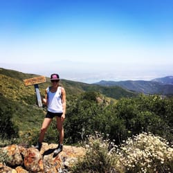
-10 mile roundtrip hike. -Starts basically to the right side of the candy store right off the Ortega Hwy. -Park at the lot across the street, passes sold at the candy store I think. -May want to get a map from the candy store they are very helpful in directing you in the right direction, and yes we used the map at different forks on the trail. -Log in your name and name of trail before it starts. I'm guessing for safety reasons. We didn't see one person on the trail, so best b safe and log in! -Hike took us 5 hours total, but we hung out and relaxed on top. -You will know when you reach the top you will see the seal on the rock (picture below) - VIEW ON TOP IS GORGEOUS! Probably the best hike in OC, we came on a clear Easter afternoon, and the mountains were movie-esque. Such a rewarding feeling when you finally get there. Got pretty emotional myself. -Elevation: 3273ft high -At the top look for a tin can where you can log in a message and your name of your accomplishment. When we went there were pens, 3 mini notebooks dated back till 2012. Reading some of them were pretty funny! (Pictures below) There was even a little bag of oatmeal in there just in case. - The trail is great I would say not too strenuous probably somewhere on an intermediate level. Definitely very memorable can't wait to come back in the future.

Another hike that's part of the Six pack peak alternate challenge Sitton Peak was probably my most enjoyable hike out of the challenge that I've done so far. Mainly because of the conditions of Bear Canyon Trail. The trail is easy to follow with the white trail markers along the forks to let you know which direction to go when there's a split in the trail. You'll gradually gain around 1,000 feet of elevation through the first 4 miles of the trail, and the last big climb up the mountain to get to Sitton Peak will be the real challenge of the hike. The climb up Sitton can be tough so bring hiking poles for back up. Round trip the hike is 10 miles with a little over 2,000 elevation gains. The parking area for the trail is San Juan Loop & Bear Canyon trail head. You can gps search Ortega Oaks Candy Shop for accurate directions since the parking lot is right across the street. When parking make sure you remember to display your adventure pass. read more


3 years ago
I was here on Saturday, May 13, 2023. I arrived at the parking lot at 6:30am. There were a few cars in the parking lot already but there were still empty spaces. The parking lot is easy to get to. There's restrooms in the parking lot. The adventure pass is required. This is an easy hike except the last .4 of a mile closer to the peak. It's really steep. Be careful. Trekking poles are helpful coming down in that section of the hike. There were several other people in the trail today. There was a group of kids who I think were boys scouts. There are a lot of bugs and I recommend you bring insect repellent. Overall, it was an awesome hike. Happy hiking! The 74 highway is under construction. I recommend you check the 74 Ortega Highway Widening website for future closures. They occasionally have 55hr full highway closures on the weekends. It's anticipated to be completed by Spring 2025. read more


Parking is across the street from the Ortega Candy Store. If you're coming from the Lake Elsinore side, the parking entrance will be on your right, store on your left. Facing the Ortega Candy Store, the trail starts on the right so you will need to cross the street. There were a lot of people parked in the parking lot around 7:45am, but a good amount were doing the San Juan Loop trail? The trail was narrow and mostly a combination of dirt and rocks. I must have stubbed my big toe at least 10 times during this 9.8 mile round trip. Hiking boots highly recommended! Also expect to spend ~4.5 to 5 hours for this hike! For the most part, the trail was relatively okay until the last ~0.5 miles to the peak. This is where it gets very steep and you will most likely be using your hands to scramble up or down in some of these areas. At the peak, one side was completely in the fog so that kind of sucked. One other thing to mention was, most people also take a photo with the Sitton Peak signs... though there were a couple of ladies who were just chilling and sitting NEXT to the signs even with hikers coming up (rolls eyes). read more


5 years ago
Incredible hike! Start early especially in the summer!! Started at 7:15 am, luckily it was overcast and cool in the morning, but once it hit 10 am the sun started beating down...HOT!! There was a slight breeze coming through the valley, which was very inviting. This is a 10 mile out and back trail, approx 4 hour moving time. Allow some time to enjoy the peak, if it's not crowded. Unfortunately, it was crowded when we reached it. It is a gorgeous peak, with a 360° view of Cleveland National Forest. This trail is considered "hard" on alltrails, however I would place it as moderate, this trail is doable for all. I would not recommend bringing little humans on this trail, unless your little human is versed in hiking long distance and inclines. The last .5 miles of the trail, is the most grueling. The incline is steep, also watch out for loose boulders, rocks, and dirt. Take it slow and pace yourself. Wear comfortable hiking shoes/boots, use trekking poles, apply sunblock, and hydrate. Bring a lot of H2O, you'll need it. To be honest, the peak is worth every step! read more


Getting to the Sitton Peak trail is about a 5 mile hike from the Ortega Highway through the Bear Canyon trail. The short quarter mile hike up the mountain to Sitton Peak was a tough final challenge. This is not recommended for kids or anyone with mobility issues. On a hot day it's easy to overexert yourself and on a wet day ( as it was for me ) the first part can be pretty muddy and slippery. Once you get to the top, the view is AMAZING. On my visit I could see Santa Catalina Island. If you've made it as far the Sitton trailhead you might as well just hike it because the views are that good...Take your time and take breaks.. Tip - There are several unmarked trails going up and it's easy to go off trail. Don't worry, just keep going up.. Also look for trekking pole holes in the ground to see where other's have walked. read more


We did an early morning hike on Sunday (12/9/18) and reached the peak before sunrise...which was spectacular! Trailhead- you can use this address 34950 Ortega Hwy which is the candy store and the parking for the hike is directly across the street; don't forget to display your Adventure Pass for $5 or buy an annual pass at Big 5 for $30 and add a 2nd car pass for $5 and split the cost with a friend for only $17.50 if you hike a lot like me this is the best decision; the Bear Canyon Trailhead is located to the right of the candy store Trail- it was in surprisingly good shape even with all the recent rains and it is pretty wide and well marked until the last half of a mile to the peak; there are times when the trail has a connecting trail and you just want to opt to the right each time...this happens at 1.0 miles in, again at the 2 mile mark, and then at about 3.2 miles you get to a spot that I think is called "4 Corners" and you take a sharp right to leave the Bear Canyon trail to use the Sitton Peak Trail; the trail for the most part is moderately steep at times with some breaks of flat areas or decline and only gets hard once you have done 4.5 miles where you will need to take a narrow trail that will be on your right and this part is pretty steep at times where you will be using your arms to balance and support yourself and this part is difficult for about .4 miles until you reach the peak...just take this part slowly and you will be rewarded at the peak Peak- you will be rewarded with beautiful views to the west and east especially...we arrived shortly after 6 am since we started a little after 4am! It was a spectacular sunrise and we probably spent close to 45 mins at the top eating, drinking mimosas (we fancy hikers), and taking an abundance of pictures; there is a sign at the top with the name/elevation Details/Recommendations: my recording on AllTrails calculated it as 4.9 to the peak and 9.8 miles RT; it took us a little over 2 hrs to the top and about 1 hr 45 mins down with us spending about 45-60 mins at the top so I would say give yourself around 5 hrs to complete this; the elevation gain is about 2,100 ft and peak elevation is 3,273 ft; hiking poles might be helpful for the difficult half mile near the peak but can be done without; of course have hiking shoes, some water (1-2L), and some snacks, this hike is moderately difficult and anyone who hikes somewhat regularly or exercises a bit will be able to do this...because of the nearly 10 miles total young children might get fatigued read more


Relatively easy trail, 10 miles round trip. This trail is easily runable except for the .6 miles to the peak which is steep and washed out. Took me 3 hours from car to peak to car. There is no shade, and it does get a little confusing due to being over grown but once you start thinking is this the trail, a sign pops up. There is not much shade, a lot is exposed, bugs were coming out as I was descending. Not heavily trafficked at all I only saw one other person at mile 2 on the way out. Enjoy! read more


6 years ago
Enjoyed the hike with Meet Up today. We started at 7am--it was freezing cold!!! My first time on this trail--hike was tough but I made it to the peak!!! The trail gets narrow and rocky in various areas especially as you near thWear hiking shoes - NOT tennis shoes or sandals!My calories burn was over 1300 calories!!! Total steps over 13,000. read more


9 years ago
Sitton Peak stands at 3,273 feet tall and is one of the 7 peaks in the Santa Ana Mountain range. Located just off Ortega Highway 74 near Lake Elsinore, the 10-11 mile round-trip hike is a moderate to challenging experience for regular hikers. On average, the hike to Sitton Peak will take between 3.5-5.5 hours, depending on your athletic experience and amount of time spent enjoying the scenery. Enjoy a ceiling of trees during the first mile of the hike and copious wildflowers along the way. From the summit of Sitton Peak, savor lofty views of the Santa Ana Mountains. read more


Not bad for a 10 mile hike. Most of the hike is a slow and steady incline that we trucked through quickly and our butts were sore. Park across from the candy store, book it across the street and you will see the Bear Canyon Trailhead on the right. It's easy to spot. Sign in and then trek till you see the San Mateo Canyon Wilderness, about 1 mile or so. The trail is easy to find with white markers, mostly take the right. When you reach the 4 Corners, a very easy to spot flat area, take the right. The last white pole marker points you to Sitton Peak, also on the right and is on the right. It's very steep and I was glad to have my hiking boots. It was muddy the day we went so it felt safer actually since we were lodged in. The hiking boots were definitely helpful coming down! Anyways, there is a fork on this steep incline that everyone fails to mention. You can take either, but the left trail is easier and when we came down, we came down that way. There are some white fabric tied to trees to let you know you're on the right track, but it's really unnecessary. The view at the top is breathtaking. Pack a lunch because you'll be tired and hungry. We even brought cans of champagne to celebrate. The only downside is you can see the 74 (Ortega Hwy) from the peak. Otherwise, it has been my favorite hike in Orange County. read more


-10 mile roundtrip hike. -Starts basically to the right side of the candy store right off the Ortega Hwy. -Park at the lot across the street, passes sold at the candy store I think. -May want to get a map from the candy store they are very helpful in directing you in the right direction, and yes we used the map at different forks on the trail. -Log in your name and name of trail before it starts. I'm guessing for safety reasons. We didn't see one person on the trail, so best b safe and log in! -Hike took us 5 hours total, but we hung out and relaxed on top. -You will know when you reach the top you will see the seal on the rock (picture below) - VIEW ON TOP IS GORGEOUS! Probably the best hike in OC, we came on a clear Easter afternoon, and the mountains were movie-esque. Such a rewarding feeling when you finally get there. Got pretty emotional myself. -Elevation: 3273ft high -At the top look for a tin can where you can log in a message and your name of your accomplishment. When we went there were pens, 3 mini notebooks dated back till 2012. Reading some of them were pretty funny! (Pictures below) There was even a little bag of oatmeal in there just in case. - The trail is great I would say not too strenuous probably somewhere on an intermediate level. Definitely very memorable can't wait to come back in the future. read more


8 years ago
This hike has pretty much the best mountain views near the OC area!! For a view that this hike has to offer, it's a fairly easy hike for someone who hikes regularly. (About 9.5 miles round trip is what my Apple Watch told me). If you're new to hiking I would not recommend trying to make it all the way to the peak and back. But for anyone who hikes occasionally you can definitely do this. This is by far my favorite hike that I have done in the OC area. The views are breathtaking and it's not very steep at all until the last 3/4 mile to the peak. Park across the street from the candy store. Walk across the highway and purchase a parking pass from the candy store. (The people there are very friendly and helpful). The trailhead is on the same side of the road of the candy store to the right. The hike is fairly easy for the first about 4 miles. Pretty shaded in places and lots of animals, birds, and lizards to name a few. (We even seen a male and female deer). Follow the white sticks in the ground all the way towards "4 corners". Once you reach 4 corners you will take a sharp right onto the Sitton Peak trail which will be marked by a white stick in the ground. You will go a pretty good ways on what looks like an old truck trail. Then you will get to the challenging part which will also be marked by a wooden stake in the ground that will say Sitton Peak, the trail gets very narrow and very steep for the last 3/4 mile. Once you get to the top you will have a great 360 degree view. There's a sign that marks the peak. I would definitely recommend bringing almost a half gallon of water for each hiker and a few snacks as well. I had 32oz of water and ran out on the way back. But I was ok. Hiking shoes or boots are highly highly recommended as it gets slippery from the dry gravel and rock. I would even bring hiking sticks if I had them and also sunscreen and chapstick. This is a very fun hike and totally worth it. I would start early in the AM as it warms up quickly. Total time out of the car was about 4.5 hours with a couple stops for drinks/snacks and photos. Enjoy!! read more


10 years ago
9 years ago
More info about Sitton Peak
Sitton Peak Truck Trl
Lake Elsinore, CA 92530
Directions
Hours
Outdoor Amenities
Sitton Peak Reviews in Other Languages
Ask the Community - Sitton Peak
Review Highlights - Sitton Peak
You might also consider


Sitton Peak - hiking - Updated July 2026
Best of Lake Elsinore
People found Sitton Peak by searching for…
Wildflowers in Lake Elsinore, CA
Beautiful Views in Lake Elsinore, CA
Places to Take Pictures in Lake Elsinore, CA
Hiking Trails in Lake Elsinore, CA
Off Road Trails in Lake Elsinore, CA
Sunrise View in Lake Elsinore, CA
Natural Hot Springs in Lake Elsinore, CA
Photo Spots in Lake Elsinore, CA
Walking Trails in Lake Elsinore, CA
View Points in Lake Elsinore, CA
Empty Parking Lot in Lake Elsinore, CA
Sunrise Hike in Lake Elsinore, CA
Canyoneering in Lake Elsinore, CA
Free Things to Do in Lake Elsinore, CA
Scenic Spots in Lake Elsinore, CA
Easy Hikes in Lake Elsinore, CA
Scenic Overlook in Lake Elsinore, CA
National Parks in Lake Elsinore, CA
Scenic View in Lake Elsinore, CA
Trending Searches in Lake Elsinore, CA
Black Owned Nail Salons in Lake Elsinore, CA
Boat Rental in Lake Elsinore, CA
Cliff Jumping in Lake Elsinore, CA
Day Trips in Lake Elsinore, CA
Dog Swimming in Lake Elsinore, CA
Jet Ski Rental in Lake Elsinore, CA
Kayak Rental in Lake Elsinore, CA
Lakes & Ponds in Lake Elsinore, CA
Off Road Trails in Lake Elsinore, CA
Outdoor Activities in Lake Elsinore, CA
Picnic Spots in Lake Elsinore, CA
Places To Walk Around in Lake Elsinore, CA
Public Pools in Lake Elsinore, CA
Public Shower in Lake Elsinore, CA
River Swimming in Lake Elsinore, CA
River Tubing in Lake Elsinore, CA
Rock Quarry in Lake Elsinore, CA
Running Trails in Lake Elsinore, CA
Scenic Night View in Lake Elsinore, CA
Scenic Overlook in Lake Elsinore, CA
Soccer Store in Lake Elsinore, CA
Splash Pad in Lake Elsinore, CA
Sunrise View in Lake Elsinore, CA
Swimming Holes in Lake Elsinore, CA
Swimming Lakes in Lake Elsinore, CA
U Pick Farms in Lake Elsinore, CA
Watch Sunset in Lake Elsinore, CA
Browse Articles
Browse Nearby
BEST of Lake Elsinore, California Parks near Sitton Peak
BEST of Lake Elsinore, California Coffee near Sitton Peak
BEST of Lake Elsinore, California Restaurants near Sitton Peak
BEST of Lake Elsinore, California Photo Spots near Sitton Peak
BEST of Lake Elsinore, California Campgrounds near Sitton Peak
BEST of Lake Elsinore, California Watch Sunset near Sitton Peak
BEST of Lake Elsinore, California Breakfast near Sitton Peak
Browse Brands
Related Searches in Lake Elsinore, CA
Affordable Kayak Rental Services in Lake Elsinore, California
Best Fishing Locations and Guides in Lake Elsinore, California
Best Nature Trails for Hiking in Lake Elsinore, California
Best Places for Horseback Riding in Lake Elsinore, California
Best Waterfalls and Swimming Holes in Lake Elsinore, California
Check Out Off Road Trails in Lake Elsinore, California
Discover Dog Friendly Trails to Explore in Lake Elsinore, California
Discover Kid Friendly Hiking Trails in Lake Elsinore, California
Discover Scenic Hiking Trails in Lake Elsinore, California
Discover Scenic Waterfall Spots in Lake Elsinore, California
Discover Top Nature Parks to Visit in Lake Elsinore, California
Discover a Hiking Trail in Lake Elsinore, California
Discover the Best Night Hike Trails in Lake Elsinore, California
Dog-Friendly Hikes With Dogs in Lake Elsinore, California
Enjoy Camping Adventures Around Lake Elsinore, California
Enjoy Exciting Mountain Biking Adventures in Lake Elsinore, California
Enjoy Kayaking Adventures in Lake Elsinore, California
Enjoy Tent Camping Spots Around Lake Elsinore, California
Enjoy a Beautiful Waterfall Hike in Lake Elsinore, California
Enjoy the Best Picnic Spots and Ideas in Lake Elsinore, California
Enjoy the Best Walking Path in Lake Elsinore, California
Enjoy the Best Walking Trails in Lake Elsinore, California
Exciting Cliff Jumping Spots in Lake Elsinore, California
Explore Beautiful Parks and Green Spaces in Lake Elsinore, California
Explore Easy Hikes Perfect for All in Lake Elsinore, California
Explore Fun Activities to Do in Lake Elsinore, California
Explore Popular Campgrounds Near Lake Elsinore, California
Explore the Best Beach Spots in Lake Elsinore, California
Explore the Best Swimming Holes Around Lake Elsinore, California
Explore the Best Trail Options in Lake Elsinore, California
Family Friendly Hiking With Kids in Lake Elsinore, California
Find Popular Ziplining Spots Around Lake Elsinore, California
Find the Best Parks for Picnics in Lake Elsinore, California
Find the Best Scenic View Locations in Lake Elsinore, California
Great Places to Walk in Lake Elsinore, California
Hike the Popular Waterfall Trail in Lake Elsinore, California
Hiking Trails With Waterfalls in Lake Elsinore, California
Off Leash Dog Hiking Trails in Lake Elsinore, California
Popular Outdoor Activities to Try in Lake Elsinore, California
Popular Picnic Spots to Visit in Lake Elsinore, California
Safe River Swimming Areas in Lake Elsinore, California
Safe and Fun Parks for Kids in Lake Elsinore, California
Top Climbing Spots and Gyms in Lake Elsinore, California
Top Paddleboarding Activities in Lake Elsinore, California
Top Places for Snorkeling in Lake Elsinore, California
Top Running Trails to Explore in Lake Elsinore, California
Top Swimming Lakes to Enjoy in Lake Elsinore, California
Top Swimming Spots and Pools in Lake Elsinore, California
Walk Dog Friendly Hiking Trails in Lake Elsinore, California
Walk the Best Paved Walking Trails in Lake Elsinore, California
People who viewed Sitton Peak also viewed
Ortega Falls
60 reviews
Walker Canyon Ecological Reserve
144 reviews
San Juan Loop Trail
1 review
Morgan Trail
2 reviews
Main Divide Trail to Los Pinos Peak
2 reviews
Los Pinos Peak
2 reviews
Crystal Cove State Park: El Moro Canyon
165 reviews
Bedford Peak Trail
7 reviews
Valido Trail
84 reviews
Red Rock Canyon
135 reviews