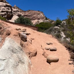
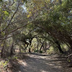
Red Rock Canyon Hiking Photos


You might also consider
More like Red Rock Canyon
Recommended Reviews - Red Rock Canyon
Start your review...

Reviews With Photos

One of our weekends, my family and I decided to go hiking. I didn't expect to see anything unusual here, there was a normal trail and shady alleys at the beginning of the journey. But when we got to the end of the canyon, we saw these majestic red rocks, and it was like a picture from another planet! It's very impressive and beautiful. It's quite an easy path even for children.

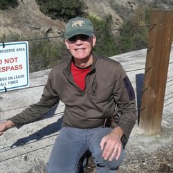
What a beautiful, peaceful hike. This trail has been suggested a few times but I would often forget. I decided that on my day off I should go hike and I randomly remembered Red Rock. I was glad I read some reviews because I was going to map it from this address and someone noted that it takes you to a private lot/property and suggested mapping it to the Ralph's off Portola. I knew exactly where that was because I used to work right by there. Some reviews suggest not parking at Ralph's because they will ticket or tow. Some people say buy some drinks and snacks at Ralph's first and you will be fine. I'm not sure how they clarify that but it's up to you. People also said it's safe to park at McDonald's across the street and other people say no. I decided to be safe and paid the $3 to park at the Whiting Ranch parking lot. There is very limited parking here so I arrived early. There were already warning signs of mountain lion sightings and deeper into the trail there were pictures of sightings of coyotes and posters about snakes. I decided to wait until the weather was cool and we went early at 7am and were lucky to avoid everything. We only spotted rabbits, squirrels and birds. To walk to the Red Rock Canyon at the end of the path from this entrance, I'm guessing was about 2.5 miles each way. (I'm guessing by my watch which only seems to match steps and we all have different strides). Myself, Steven, and fellow yelp friend Vince all went together for our first time. A lot of this trail was soft sand, sometimes it felt like a beach. There were various small inclines and declines the whole time and a ton of loose rocks. We felt a little tired going there but surprisingly it was really easy to make the 2.5 mile trip back. There were random parts of the trail where we felt cold, quite warm, then cold again. The rocks were beautiful. I really wanted to get a picture in the small path in between two large red rocks but there were signs saying not to and I was told not to break the rules. (We saw various wilderness cameras during our walk) I really enjoyed this trip and I am glad we went early because we saw a ton of groups of hikers headed towards the rocks on our way back. Talk about good timing. I appreciated all of the friendly people saying good morning and happy New Year. What a nice change! I also recommend pulling up Google maps and just opening it to see where your dot is. It will show the path (the dead end of the straight-ish line) so you know you haven't diverted the wrong way. (This is possible, there are little forks) I highly recommend checking it out.


People love taking pictures of where the red rocks are. They have an area at the end of a trail/halfway point, that people utilize for photo opportunities. This trail has a parking lot, I paid three dollars for the day, when we returned around 10 something, the parking lot was full. In the area there is a big plaza with stores and restaurants. The street itself is not too far from the 5 freeway. I did see a port-o-potty bathroom at the trailhead entrance.

It's a chill hike with very scenic views! Walking and hiking on this trail is very therapeutic and you can smell nature (i was able to smell eucalyptus, im not sure but something like that!) which feels so good! There is parking but you have to pay $3. I would suggest parking near mcdonalds or nearby... i love this trail!


Don't get confuse Red Rock Canyon & Red Rock State Park. Parking: limited parking. Parking Fee: $3 daily. Machine accepts $1 bills and quarters or Visa/Master Card and OC Parks Annual Pass Open every day except close after the rain 4.2 miles RT Easy Kids friendly not stroller friendly Portable bathrooms @ trailhead. .No bathroom along the trail Trail - dirt and small rocks - Limited of shade Crowded with hiker and biker. End of trail is very windy, please be careful not to fall from climbing the rock and get sand in your eyes. If you don't want to get lost, please check out this website before you go, its have very detail information of the trail. https://hikingguy.com/hiking-trails/hiking-orange-county/whiting-ranch-hiking-red-rock-canyon/

Pretty easy hike to bring engineers to. We did the Borrego Canyon Trail to Red Rock Canyon and it took a little around 2 hours. The hike is about 4.1 miles and is east to follow, it's pretty much a straight line into the canyon. It's relatively flat but gets a little rocky near the end. Pretty warm in the summer, so get here early before it gets too hot. Nice scenery of the red rock formations once you reach the end of the trail.


1st time exploring this place 26701 Portola Pkwy Lake Forest led me to Whiting ranch wilderness park where there is also a small parking lot for a fee of $3 - notice people parking at Ralph's parking lot but rumor of people cars being check and tow - so park at your own risk ..? Trail said to open at 7 and got to the parking lot around 645am and already 2 cars parked - dogs are not allowed. Mountain lions signs posted. Plenty of trees, tree tunnels, and shade. Few different types of birds spotted, squirrel, chipmunks, and gophers Definitely plenty of rocks on trail so have sturdy shoes (don't recommend chucks / tons / sandals / etc) Sunblock, hat, water, bug spray maybe depending time going Ventured to red canyon and actually followed the signs and didn't go exploring in the canyon though it was tempting - cooler on the ground and as getting closer warmed up even with the shade. Pretty to see but to go that way and then be like well that it, a bit disheartening but also understood it's nature to see and admire and not ruin with ware and tear over time. Best to go early and get this done as more people were in route for this Mustard trail - steep incline up a hill leads to 4 corners - Wider trail but pretty as once reach the top overlooks the area Billy goat - name as it intended - hiker trail only - narrow windy goes up and down with many rocks - take this at a slower pace because a wrong step can lead to a slide off and there aren't any protective barriers to prevent one from falling - once on top it connects to "four corner" mustard area - additional trails are also available once in the area Definitely a place I return to - easy to access - bicyclist mostly friendly - felt safe when exploring on my own - parking easy to access - clean and wide trails pending direction going - hidden away from the city

Perfect for a birthday hike! This was also our first family hike as 4. My littlest is 1 and we put her in a backpack. This is not a stroller friendly trail as you have to cross pebbles/stones and streams. It took us an hour and a half to get there as it's uphill at some points and tough for a 4 year old to keep up. And an hour on the way back. But once you get to the canyon, it's breathtaking. Serene, stunning and feels like you're not in California anymore. The start of the trail is shaded and then it gets pretty hot in the open areas. Park at 26701 Portola parkway. There are limited parking spots and the fee is $3 for the day. DO NOT park at the Ralph's next door. There is a security vehicle that follows people around and tows cars if he sees you walking into the trail.

Easy hike up, but you'll want to park on 26701 Portola Pkwy, Foothill Ranch, CA 92610 to get to this spot. There is a $3 fee for the parking lot but it's also next to the Ralphs parking lot too...so there's that option as well. I went in the evening when the sun was setting and honestly that is a nice time to see the rocks actually red but do note that you'll probably be coming back in the dark if you want to watch the sunset here. Going 3/4ths of the way is very well shaded and it's super easy and requires nothing more than just a casual walk. Just don't touch any Poison Oak (green stuff). After you hit a junction, you want to turn right and then make a left when you see a sign that points to Red Rock Canyon, .6 miles or something like that. It's super easy, and the round trip is about 2 hours if you're walking really slow like me. For being so close to civilization, I think it's pretty cool to see such a rock formation that usually exists in some place in Arizona and Utah, and then find a smaller version close to home. Definitely worth it for a short hike.

One of the coolest hikes I've done, Red Rock Canyon starts as a pretty typical forest trail. It's really easy and chill, but watch out for snakes midway through! Once you get past the woods and make it to the end, you're met with all the red rock plateaus and it's so cool to see and be around! Really beginner friendly, just make sure to pack water and snacks :) read more


Red Rock Canyon is located at the Whiting Ranch Wilderness Trail. To get here there are different hiking trails but the most popular one is probably the Borrego Canyon Trail. It's only a 1.8 mile hike one way to get to the intersection where you can continue straight to get on the Red Rock Canyon trail. You'll know when you're at the end when you see signs and the large red rock structures all around you. The red rocks really reminded me of the sights that I saw in Arizona and Utah. It was really cool to see some of that in California. read more


3 months ago
One of our weekends, my family and I decided to go hiking. I didn't expect to see anything unusual here, there was a normal trail and shady alleys at the beginning of the journey. But when we got to the end of the canyon, we saw these majestic red rocks, and it was like a picture from another planet! It's very impressive and beautiful. It's quite an easy path even for children. read more

What a beautiful, peaceful hike. This trail has been suggested a few times but I would often forget. I decided that on my day off I should go hike and I randomly remembered Red Rock. I was glad I read some reviews because I was going to map it from this address and someone noted that it takes you to a private lot/property and suggested mapping it to the Ralph's off Portola. I knew exactly where that was because I used to work right by there. Some reviews suggest not parking at Ralph's because they will ticket or tow. Some people say buy some drinks and snacks at Ralph's first and you will be fine. I'm not sure how they clarify that but it's up to you. People also said it's safe to park at McDonald's across the street and other people say no. I decided to be safe and paid the $3 to park at the Whiting Ranch parking lot. There is very limited parking here so I arrived early. There were already warning signs of mountain lion sightings and deeper into the trail there were pictures of sightings of coyotes and posters about snakes. I decided to wait until the weather was cool and we went early at 7am and were lucky to avoid everything. We only spotted rabbits, squirrels and birds. To walk to the Red Rock Canyon at the end of the path from this entrance, I'm guessing was about 2.5 miles each way. (I'm guessing by my watch which only seems to match steps and we all have different strides). Myself, Steven, and fellow yelp friend Vince all went together for our first time. A lot of this trail was soft sand, sometimes it felt like a beach. There were various small inclines and declines the whole time and a ton of loose rocks. We felt a little tired going there but surprisingly it was really easy to make the 2.5 mile trip back. There were random parts of the trail where we felt cold, quite warm, then cold again. The rocks were beautiful. I really wanted to get a picture in the small path in between two large red rocks but there were signs saying not to and I was told not to break the rules. (We saw various wilderness cameras during our walk) I really enjoyed this trip and I am glad we went early because we saw a ton of groups of hikers headed towards the rocks on our way back. Talk about good timing. I appreciated all of the friendly people saying good morning and happy New Year. What a nice change! I also recommend pulling up Google maps and just opening it to see where your dot is. It will show the path (the dead end of the straight-ish line) so you know you haven't diverted the wrong way. (This is possible, there are little forks) I highly recommend checking it out. read more


4 months ago
What a great local hike. So convenient yet allowing escape from the city. Good for the family. Anticipate a few rest stops with little kids. Red rock canyon was amazing. Stay on the trails for me encountered a baby rattle snake! read more


6 months ago
5 months ago
So much beauty to see in a 4 mile round trip. Easy hike. Jungle meets Badlands. One of my favorite trails this year. read more


People love taking pictures of where the red rocks are. They have an area at the end of a trail/halfway point, that people utilize for photo opportunities. This trail has a parking lot, I paid three dollars for the day, when we returned around 10 something, the parking lot was full. In the area there is a big plaza with stores and restaurants. The street itself is not too far from the 5 freeway. I did see a port-o-potty bathroom at the trailhead entrance. read more


5 months ago
It's a chill hike with very scenic views! Walking and hiking on this trail is very therapeutic and you can smell nature (i was able to smell eucalyptus, im not sure but something like that!) which feels so good! There is parking but you have to pay $3. I would suggest parking near mcdonalds or nearby... i love this trail! read more


1 year ago
Fun easy hike, I have no complaints. It's about a mile walk to get to the actual hike but when you're there it's absolutely gorgeous. It reminded me of a scene from cars. Also, you need to pay $5 for parking. read more


Don't get confuse Red Rock Canyon & Red Rock State Park. Parking: limited parking. Parking Fee: $3 daily. Machine accepts $1 bills and quarters or Visa/Master Card and OC Parks Annual Pass Open every day except close after the rain 4.2 miles RT Easy Kids friendly not stroller friendly Portable bathrooms @ trailhead. .No bathroom along the trail Trail - dirt and small rocks - Limited of shade Crowded with hiker and biker. End of trail is very windy, please be careful not to fall from climbing the rock and get sand in your eyes. If you don't want to get lost, please check out this website before you go, its have very detail information of the trail. https://hikingguy.com/hiking-trails/hiking-orange-county/whiting-ranch-hiking-red-rock-canyon/ read more


4 years ago
Pretty easy hike to bring engineers to. We did the Borrego Canyon Trail to Red Rock Canyon and it took a little around 2 hours. The hike is about 4.1 miles and is east to follow, it's pretty much a straight line into the canyon. It's relatively flat but gets a little rocky near the end. Pretty warm in the summer, so get here early before it gets too hot. Nice scenery of the red rock formations once you reach the end of the trail. read more


11 months ago
1st time exploring this place 26701 Portola Pkwy Lake Forest led me to Whiting ranch wilderness park where there is also a small parking lot for a fee of $3 - notice people parking at Ralph's parking lot but rumor of people cars being check and tow - so park at your own risk ..? Trail said to open at 7 and got to the parking lot around 645am and already 2 cars parked - dogs are not allowed. Mountain lions signs posted. Plenty of trees, tree tunnels, and shade. Few different types of birds spotted, squirrel, chipmunks, and gophers Definitely plenty of rocks on trail so have sturdy shoes (don't recommend chucks / tons / sandals / etc) Sunblock, hat, water, bug spray maybe depending time going Ventured to red canyon and actually followed the signs and didn't go exploring in the canyon though it was tempting - cooler on the ground and as getting closer warmed up even with the shade. Pretty to see but to go that way and then be like well that it, a bit disheartening but also understood it's nature to see and admire and not ruin with ware and tear over time. Best to go early and get this done as more people were in route for this Mustard trail - steep incline up a hill leads to 4 corners - Wider trail but pretty as once reach the top overlooks the area Billy goat - name as it intended - hiker trail only - narrow windy goes up and down with many rocks - take this at a slower pace because a wrong step can lead to a slide off and there aren't any protective barriers to prevent one from falling - once on top it connects to "four corner" mustard area - additional trails are also available once in the area Definitely a place I return to - easy to access - bicyclist mostly friendly - felt safe when exploring on my own - parking easy to access - clean and wide trails pending direction going - hidden away from the city read more


 - Hiking Near Me - Lake Forest, California")


1 year ago
1 year ago
6 years ago
Perfect for a birthday hike! This was also our first family hike as 4. My littlest is 1 and we put her in a backpack. This is not a stroller friendly trail as you have to cross pebbles/stones and streams. It took us an hour and a half to get there as it's uphill at some points and tough for a 4 year old to keep up. And an hour on the way back. But once you get to the canyon, it's breathtaking. Serene, stunning and feels like you're not in California anymore. The start of the trail is shaded and then it gets pretty hot in the open areas. Park at 26701 Portola parkway. There are limited parking spots and the fee is $3 for the day. DO NOT park at the Ralph's next door. There is a security vehicle that follows people around and tows cars if he sees you walking into the trail. read more


Easy hike up, but you'll want to park on 26701 Portola Pkwy, Foothill Ranch, CA 92610 to get to this spot. There is a $3 fee for the parking lot but it's also next to the Ralphs parking lot too...so there's that option as well. I went in the evening when the sun was setting and honestly that is a nice time to see the rocks actually red but do note that you'll probably be coming back in the dark if you want to watch the sunset here. Going 3/4ths of the way is very well shaded and it's super easy and requires nothing more than just a casual walk. Just don't touch any Poison Oak (green stuff). After you hit a junction, you want to turn right and then make a left when you see a sign that points to Red Rock Canyon, .6 miles or something like that. It's super easy, and the round trip is about 2 hours if you're walking really slow like me. For being so close to civilization, I think it's pretty cool to see such a rock formation that usually exists in some place in Arizona and Utah, and then find a smaller version close to home. Definitely worth it for a short hike. read more


@26701 Portola Pkwy. Don't follow Google Maps Trail is relatively simple until you get to the junctions, beautiful and quiet. The Hike is around 4 Miles Round Trip, not a strenuous hike in any way, perfect for biking and kids too! You'll be rewarded at the end of the trail with a beautiful geological formation. read more

1 year ago
I keep forgetting i was here a year ago & after coming back for another hike with my hubby i just had to update this! I love coming here early morning because it's quiet & not a lot of people on the trail which i love. I love that there is this awesome place in the OC because it gives me such pretend AZ vibes! I can't find more pics of when we went but i promise it was a good time! It is not a long hike at all, so just something to note. read more

1 year ago
6 years ago
** ADDRESS: 26701 Portola Parkway, Foothill Ranch, CA 92610. Make sure you look at the driving directions and that you arrive at the correct location. ** TRAIL DESCRIPTION: This is an easy canyon hiking trail in the Whiting Ranch Wilderness Park. At the end of the trail, we were rewarded with a scenic view of multiple "red rock" formations. The red rock formations popped in a series of striking pinkish-to-red hues. ** TRAIL TERRAIN AND LENGTH: The hike took about 2 hours (approximately 4 miles roundtrip). The initial launching point was the "Borrego Canyon Trail" (which is accessed directly from the small parking lot located near the main park entrance area). Hikers, pedestrians, cyclists and horseback riders all share the Borrego Canyon Trail. So, on a crowded day, you will probably be sharing the Borrego Canyon Trail with lots of other people before you arrive at the separate "Red Rock Canyon Trail." From the Borrego Canyon Trail, you will eventually see a trail marker leading to the Red Rock CanyonTrail. The Red Rock Canyon Trail is limited to hikers only. Although there were some steeper inclines and slippery declines along the way, most of the trail was relatively comfortable (with hiking boots), although you can expect to find the usual assortment of rocks; and a few slippery muddy areas scattered along the trail (depending on the weather). ** PARKING AND PARKING FEES: Parking is very limited because there is only one small parking lot located near the park entry area. The parking fee was $3.00 and the parking machine accepted quarters/dollar bills (or Visa or MasterCard) at the pay station. Some people parked their cars across the street in a shopping center BUT there was a security patrol in the shopping center that could tow your car for parking in the shopping center - so be very CAREFUL about parking in this area. Fortunately, we arrived sufficiently early in the morning so we were able to park our car in the small parking lot located near the main trail entry area. ** HOURS, RESTROOM FACILITY, AND DRINKING WATER FOUNTAIN: The park was open from 7 AM until sunset on the day that we hiked the trail. There was also a small restroom facility and drinking water fountain in the entry area. It's advisable to bring water with you because you will probably want to remain hydrated on the trail - especially if the weather is warm. read more

2 years ago
Nice hike, I would rate easy to moderate intensity. You get to see distinctively different terrains throughout the hike, which tookme 2.5 hrs at a leisurely pace. It's in- and-out, with an anticlimactic ending so if you were expecting to see or get into the slot canyons, be prepared to be disappointed. Due to erosion and risk of falls/getting stuck, you can only hike up to the entrance of the canyons. Still a cool view and you can still see the swirl of red and light sand on the ground on the way up to the red rocks. Parking is $3 for the park's lot, which abuts next to a shopping center where you could probably sneak in for free parking. Make sure to navigate to the entrance specifically at 26701 Portola Pkwy, Lake Forest, CA 92610 or you'll end up on the other side and it would take you through a much longer and more difficult hike to get to the red rocks trail. No dogs allowed on the trail but I did see ppl pushing baby strollers down the "easy" trail going down Borrego Canyon. read more


Parking is $3 It's across the street from a giant plaza with Walmart and right next to Ralph's supermarket Avoid the crowds by going early in the morning It took me 2 hours to complete the trail Very easy to complete Appreciated how the trail was clearly marked with maps and signs along the way. Tips Wear sunscreen (parts of the trail is shaded!!) Wear a hat Bring water and snacks read more


I absolutely love this trail. I've been hiking Whiting Ranch for years and only recently heard of Red Rock Canyon. I had a little trouble finding it at first, so here's a hint, if you're in the same boat: once you hit the fork in the path (where the map is and mustard loop is on your right), take the right path, and keep left until you see a lone bench under a tree. You should see the sign there! The hike itself is not too difficult, and there are actually a couple of areas that lead to unmarked portions of the trail which are fun to explore. I did see a snake on one of my trips here, so just be observant. Once at the canyon though, the views are amazing! And there's a portion on the right that is not too difficult to climb to get an even better view of Whiting. https://www.yelp.com/biz_photos/red-rock-canyon-lake-forest?select=xeNpvhyje8VE1FU2o2wHpg&userid=97Dj5h5CQUsWZrEWj3wWOg https://www.yelp.com/biz_photos/red-rock-canyon-lake-forest?select=Sp06LBe5MpTVqMyilLg09Q&userid=97Dj5h5CQUsWZrEWj3wWOg https://www.yelp.com/biz_photos/red-rock-canyon-lake-forest?select=eukLU46QpkxNTQJ5wTckFQ&userid=97Dj5h5CQUsWZrEWj3wWOg https://www.yelp.com/biz_photos/red-rock-canyon-lake-forest?select=4mD9T8SNK3cUnv388S0hVg&userid=97Dj5h5CQUsWZrEWj3wWOg https://www.yelp.com/biz_photos/red-rock-canyon-lake-forest?select=Lsg0Y1demefN2f-CCbz9_w&userid=97Dj5h5CQUsWZrEWj3wWOg read more


Great short distance (4 mile) hike in Lake Forest/Forest Hills area where the entrance is nearby to many businesses in the community. (Total time is just over 2 hrs) Tip: Avoid using Google Maps as they'll lead you to an incorrect location at a gated house. Search for Portola Parkway across from McDonald's for the entrance. Parking is tight with about a dozen spots and a self-pay parking machine for $3: Follow the signs from the trailhead and you'll see bikers zipping along the way. Be cautious. The path starts off with nice homes surrounding cliffs but after several hundred yards you'll find yourself transported to a beautiful trail with canyon views. Bring plenty of water and leave early as there are limited shade spots on the hike. read more


4 years ago
Visited on 06/26/2022 (Sunday). We started around 5:30 in the afternoon to avoid the heat and came back just before 7:30, and the sun was still high in the sky. We saw rabbits multiple times and blue jay (Cyanocitta) and 2 dears (mom and baby), they are so adorable. Very easy hike and pretty flat, just mild climbing toward the Red Rock at the end. read more


Parking : there is a small lot by the trailhead with $3 parking, but most people seemed to be parking in the Ralph's parking lot which is adjacent to it. The address is 26751 Portola Pkwy, Foothill Ranch, CA 92610! Length : we finished the entire hike in less than two hours, including taking photos along the way and at the end of the trail. It was a little over 4 miles, and we got over 10,000 steps (according to Fitbit). Difficulty : the main trail has little elevation change and is really easy to hike! We all wore nikes and were fine. When you cut onto the red rock trail it gets rockier, but still isn't hard. We definitely got warm from the sun but there's some shaded spots to recover in too. Also be alert of mountain bikers- there are a lot! Hike : WOULD HIGHLY RECOMMEND!! This is seriously a hidden gem of a hike. The red rock is beautiful and looks like it could be another state, and it's not overly crowded so you can take it in and really enjoy it. The hike itself isn't terribly challenging, and it's the perfect length where you're not exhausted but you still feel accomplished. read more


7 years ago
Super beautiful. Not too crowded. Worth the hike :) make sure to pay attention to the trail markers & maps. The trail leading off to red rock can be easily missed from the main trail! And again don't follow the yelp or google address. Type in 26701 Portola Pkwy Foothill Ranch, CA 92610 United States That's where you can park & start on the trail! read more


** WARNING: DO NOT FOLLOW THE DIRECTIONS ON YELP OR GOOGLE. It will take you to a random private driveway!!! ** REAL ADDRESS: 26701 Portola Pkwy, Foothill Ranch, CA 92610 This is a super easy hike, perfect for beginners and children. There is another trail that is much longer you can take if you want to be challenged, which includes Dreaded Hill and is 10 mi, but it starts elsewhere. The one starting from the Ralph's plaza is about 4 mi. = P A R K I N G = There is a tiny lot you can pay $3 to park in. However, since the lot is very popular, you might find it full. There are many signs saying not to park in Ralph's, but uh...what can you do sometimes? = T R A I L = Mostly FLAT and SHADED. the most elevation gain is at the end, when you're climbing into the actual canyon. The trail is well kept and free of trash. At the end, you'll be rewarded with dramatic...you guessed it...red rocks! Not nearly as satisfying as a breathtaking view, but it is still very cool. read more

One of my favorite trails in Orange County just because it's easy, decently shaded, and not too far of a walk. Only problem is that it's popular among bikers so don't listen to music when you walk, you can get ran over. Also, I ran into a ranger up there and realized you aren't suppose to climb the rocks, oopsies. Other than that, hidden gem in the area! Tip: Park across the street at CVS and walk over if you cant find any spots and are afraid to park in the Ralph Plaza. If not, it's $3 for a spot in front if you can even find one. read more


5 years ago
One of my favorite hikes so far! Had a bit of everything. Lots of shade in the beginning. The end of the hike was super rewarding with the beautiful red rock canyon scene. Walking back felt like a different view as well. Will come back! read more


7 years ago
Amazing hike! Definitely worth it, but I would get there in between 8am-9am to avoid all the people because it is a very popular hike. Also, we had a little trouble figuring out where the trail head was. Use this address: 26701 Portola Pkwy Foothill Ranch, CA 92610 United States read more

Page 1 of 4
More info about Red Rock Canyon
Red Rock Trl
Lake Forest, CA 92610
Directions
Hours
Indoor Amenities
Outdoor Amenities
Ask the Community - Red Rock Canyon
Is there one/multiple trail options? (If there are multiple ones which ones does everyone recommend?)
Is Red Rock Canyon trail open?
No it is not open due to fires. They said it should opening up during Spring maybe sooner
As of January 2021, anyone know if this trail is open?
Closed due to mountain lions. Verified today.
Is the trail open right now? Came last week & it was closed due to a mountain lion sighting.
main lot is not open due to the fires last month.
What time does it open?
Per the map at the Market Place Street entrance of the Whiting Ranch Wilderness Park, the OC Park is open 7am to sunset (for day use).
Are there dogs allowed?
Dogs are not allowed. Some paths are pretty narrow and there are snakes- we saw 2.
Where do you park?
There's parking in the Ralph's Plaza or paid parking at Whiting Ranch - where the trail starts.
Review Highlights - Red Rock Canyon
You might also consider


![Falls Canyon Falls - Falls Canyon Falls/Trabuco Falls/Hidden Falls!! [?!...] - http://bit.ly/1CHQrJa](https://s3-media0.fl.yelpcdn.com/bphoto/bi3zkMU9HqPVcUKBk8AmiA/ls.jpg)


Why does Yelp recommend reviews?
Red Rock Canyon - hiking - Updated May 2026
Best of Lake Forest
People found Red Rock Canyon by searching for…
Things to Do in Lake Forest, California
Hiking Trails in Lake Forest, California
Places to Take Pictures in Lake Forest, California
Parks in Lake Forest, California
Beaches in Lake Forest, California
Photo Spots in Lake Forest, California
Off Road Trails in Lake Forest, California
Scenic Drive in Lake Forest, California
Scenic View in Lake Forest, California
Beautiful Views in Lake Forest, California
Sunset View in Lake Forest, California
Walking Trails in Lake Forest, California
Scenic Spots in Lake Forest, California
Waterfall Hike in Lake Forest, California
Shaded Hike in Lake Forest, California
Dog Friendly Hiking Trails in Lake Forest, California
Picnic Spots in Lake Forest, California
Cliff Jumping in Lake Forest, California
Watch Sunset in Lake Forest, California
Natural Hot Springs in Lake Forest, California
Night Hiking in Lake Forest, California
Fall Foliage in Lake Forest, California
Trending Searches in Lake Forest, CA
Botanical Gardens near Red Rock Canyon
Bounce House Rentals near Red Rock Canyon
Campgrounds near Red Rock Canyon
Cheap Plants near Red Rock Canyon
Cherry Picking near Red Rock Canyon
Cliff Jumping near Red Rock Canyon
Dog Friendly Things To Do near Red Rock Canyon
Flower Fields near Red Rock Canyon
Flower Shop near Red Rock Canyon
Garage Sales near Red Rock Canyon
Garden Center near Red Rock Canyon
Lakes & Ponds near Red Rock Canyon
Nurseries & Gardening near Red Rock Canyon
Outdoor Activities near Red Rock Canyon
Outdoor Furniture Stores near Red Rock Canyon
Party Equipment Rentals near Red Rock Canyon
Photo Spots near Red Rock Canyon
Picnic Areas near Red Rock Canyon
Places To Take Pictures near Red Rock Canyon
Rock Quarry near Red Rock Canyon
Running Trails near Red Rock Canyon
Rv Rental near Red Rock Canyon
Spray Tanning near Red Rock Canyon
Sunrise View near Red Rock Canyon
Swimming Holes near Red Rock Canyon
Table And Chair Rentals near Red Rock Canyon
Browse Articles
Browse Nearby
BEST of Lake Forest, California Coffee near Red Rock Canyon
BEST of Lake Forest, California Restaurants near Red Rock Canyon
BEST of Lake Forest, California Things to Do near Red Rock Canyon
BEST of Lake Forest, California Walking Trails near Red Rock Canyon
BEST of Lake Forest, California Breakfast near Red Rock Canyon
BEST of Lake Forest, California Parks near Red Rock Canyon
BEST of Lake Forest, California Campgrounds near Red Rock Canyon
BEST of Lake Forest, California Hotels near Red Rock Canyon
BEST of Lake Forest, California Snow Tubing near Red Rock Canyon
Browse Brands
Related Searches in Lake Forest, CA
Affordable Kayak Rental Services in Lake Forest, California
Best Fishing Locations and Guides in Lake Forest, California
Best Nature Trails for Hiking in Lake Forest, California
Best Places for Horseback Riding in Lake Forest, California
Best Waterfalls and Swimming Holes in Lake Forest, California
Check Out Off Road Trails in Lake Forest, California
Discover Dog Friendly Trails to Explore in Lake Forest, California
Discover Kid Friendly Hiking Trails in Lake Forest, California
Discover Scenic Hiking Trails in Lake Forest, California
Discover Scenic Waterfall Spots in Lake Forest, California
Discover Top Nature Parks to Visit in Lake Forest, California
Discover Walking Parks in Lake Forest, California Near You
Discover a Hiking Trail in Lake Forest, California
Discover the Best Night Hike Trails in Lake Forest, California
Dog-Friendly Hikes With Dogs in Lake Forest, California
Enjoy Camping Adventures Around Lake Forest, California
Enjoy Exciting Mountain Biking Adventures in Lake Forest, California
Enjoy Kayaking Adventures in Lake Forest, California
Enjoy Tent Camping Spots Around Lake Forest, California
Enjoy a Beautiful Waterfall Hike in Lake Forest, California
Enjoy a Peaceful Nature Walk in Lake Forest, California
Enjoy the Best Picnic Spots and Ideas in Lake Forest, California
Enjoy the Best Walking Path in Lake Forest, California
Enjoy the Best Walking Trails in Lake Forest, California
Exciting Cliff Jumping Spots in Lake Forest, California
Explore Beautiful Parks and Green Spaces in Lake Forest, California
Explore Easy Hikes Perfect for All in Lake Forest, California
Explore Popular Campgrounds Near Lake Forest, California
Explore the Best Beach Spots in Lake Forest, California
Explore the Best Swimming Holes Around Lake Forest, California
Explore the Best Trail Options in Lake Forest, California
Family Friendly Hiking With Kids in Lake Forest, California
Find Beautiful Views in Lake Forest, California
Find the Best Parks for Picnics in Lake Forest, California
Find the Best Scenic View Locations in Lake Forest, California
Great Places to Walk in Lake Forest, California
Hiking Trails With Waterfalls in Lake Forest, California
Off Leash Dog Hiking Trails in Lake Forest, California
Plan a Scenic Drive Route Near Lake Forest, California
Popular Outdoor Activities to Try in Lake Forest, California
Popular Picnic Spots to Visit in Lake Forest, California
Safe River Swimming Areas in Lake Forest, California
Safe and Fun Parks for Kids in Lake Forest, California
Top Climbing Spots and Gyms in Lake Forest, California
Top Paddleboarding Activities in Lake Forest, California
Top Running Trails to Explore in Lake Forest, California
Top Swimming Lakes to Enjoy in Lake Forest, California
Top Swimming Spots and Pools in Lake Forest, California
Walk Dog Friendly Hiking Trails in Lake Forest, California
Walk the Best Paved Walking Trails in Lake Forest, California