Shingle Creek Trail Photos


You might also consider
More like Shingle Creek Trail
Recommended Reviews - Shingle Creek Trail
Start your review...

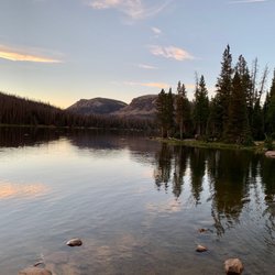
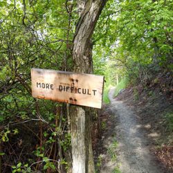
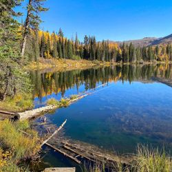
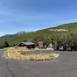
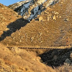
This is such an awesome trail for snowshoeing! From the trailhead your journey begins at roughly 7,500 feet on the western edge of the Uinta Mountains and ends at Shingle Creek at 9,700 feet. It's about a total of 10+ miles (out & back) with 2,200 of elevation climbing. In terms of difficulty, the trail is a combination of steep and gradual ascents that take you through beautiful forests, snow-covered meadows and bridges...finishing at Shingle Creek Lake. Our crew would rate it as moderate. All in all, the trail was nicely groomed and made for an exceptional day of snowshoeing! Be happy outside! P.S. No "Cocaine Bear" sightings ;-) read more


More info about Shingle Creek Trail
Forest Rd 054
Kamas, UT 84036
Directions
Hours
Outdoor Amenities


Shingle Creek Trail - hiking - Updated May 2026
Best of Kamas
People found Shingle Creek Trail by searching for…
Trending Searches in Kamas, UT
Bounce House Rentals near Shingle Creek Trail
Campgrounds near Shingle Creek Trail
Cliff Jumping near Shingle Creek Trail
Floral Designers near Shingle Creek Trail
Flower Arranging Classes near Shingle Creek Trail
Flower Shop near Shingle Creek Trail
Lakes & Ponds near Shingle Creek Trail
Mens Suits near Shingle Creek Trail
Mexican Catering near Shingle Creek Trail
Nurseries & Gardening near Shingle Creek Trail
Outdoor Activities near Shingle Creek Trail
Outdoor Furniture Stores near Shingle Creek Trail
Parks near Shingle Creek Trail
Party Equipment Rentals near Shingle Creek Trail
Pedicure near Shingle Creek Trail
Photo Spots near Shingle Creek Trail
Picnic Areas near Shingle Creek Trail
Plant Nursery near Shingle Creek Trail
Running Trails near Shingle Creek Trail
Rv Rental near Shingle Creek Trail
Scenic Drive near Shingle Creek Trail
Sunrise View near Shingle Creek Trail
Swimming Holes near Shingle Creek Trail
Browse Articles
Browse Brands
Related Searches in Kamas, UT
Affordable Jet Ski Rental Options in Kamas, Utah
Affordable Paddle Board Rental in Kamas, Utah
Best Fishing Locations and Guides in Kamas, Utah
Best Places for Horseback Riding in Kamas, Utah
Check Out Off Road Trails in Kamas, Utah
Discover Dog Friendly Trails to Explore in Kamas, Utah
Discover Popular Bike Trails in Kamas, Utah
Discover a Hiking Trail in Kamas, Utah
Discover the Best Night Hike Trails in Kamas, Utah
Dog-Friendly Hikes With Dogs in Kamas, Utah
Enjoy Camping Adventures Around Kamas, Utah
Enjoy Exciting Mountain Biking Adventures in Kamas, Utah
Enjoy Kayaking Adventures in Kamas, Utah
Enjoy the Best Tubing Experiences in Kamas, Utah
Enjoy the Best Walking Trails in Kamas, Utah
Experience Stunning Sunset Views in Kamas, Utah
Explore Beautiful Parks and Green Spaces in Kamas, Utah
Explore Bike Rentals Throughout Kamas, Utah
Explore Easy Hikes Perfect for All in Kamas, Utah
Explore Family-Friendly Zoos and Wildlife in Kamas, Utah
Explore Fun Activities to Do in Kamas, Utah
Explore Jet Skis for Sale or Rent in Kamas, Utah
Explore Pickleball Courts in Kamas, Utah
Explore Popular Campgrounds Near Kamas, Utah
Explore Popular RV Parks Around Kamas, Utah
Explore Scenic Lakes to Visit in Kamas, Utah
Explore Top Dog Parks in Kamas, Utah Near You
Explore Top Water Parks in Kamas, Utah Today
Explore the Best Boating Spots in Kamas, Utah
Explore the Best Trail Options in Kamas, Utah
Family Friendly Hiking With Kids in Kamas, Utah
Find Top Skate Parks in Kamas, Utah for All Skill Levels
Find Top-Rated Disc Golf in Kamas, Utah
Find the Best Playgrounds to Visit in Kamas, Utah
Find the Best Scenic View Locations in Kamas, Utah
Find the Best Swimming Pools in Kamas, Utah Today
Hiking Trails With Waterfalls in Kamas, Utah
Off Leash Dog Hiking Trails in Kamas, Utah
Popular Fishing Spots to Explore in Kamas, Utah
Popular Kids Activities in Kamas, Utah
Popular Picnic Spots to Visit in Kamas, Utah
Popular Things to Do in Kamas, Utah
Relax at Natural Hot Springs Near Kamas, Utah
Safe River Swimming Areas in Kamas, Utah
Safe and Fun Parks for Kids in Kamas, Utah
See Top Fireworks Events in Kamas, Utah
Top Playgrounds for Kids to Enjoy in Kamas, Utah
Top Running Trails to Explore in Kamas, Utah