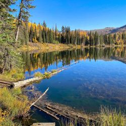
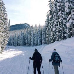
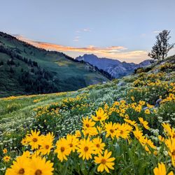
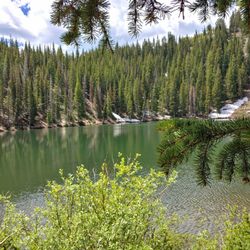
Armstrong Trail Photos


You might also consider
More like Armstrong Trail
Recommended Reviews - Armstrong Trail
Start your review...

1 year ago
8 years ago
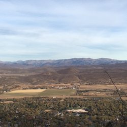
Fun hiking experience - the beginning is a little steep if your legs aren't too strong, make sure to bring plenty of water to stay hydrated. Unfortunately, it's hard to focus because you need to look over your shoulder every couple of minutes for mountain bikers so be very careful. Alot of the views are repeat views because it is pretty much one big snake and zig zag. But, overall it was a peaceful experience with good views. read more


5 years ago
10 years ago
More info about Armstrong Trail
1825 Three Kings Dr
Park City, UT 84060
Directions
Hours
Outdoor Amenities
You might also consider


Armstrong Trail - hiking - Updated July 2026
Best of Park City
People found Armstrong Trail by searching for…
Hiking Trails in Park City, UT
Hiking With Kids in Park City, UT
Beautiful Views in Park City, UT
Free Things to Do in Park City, UT
Off Road Trails in Park City, UT
Walking Trails in Park City, UT
Things to Do With Kids in Park City, UT
Dog Friendly Hiking Trails in Park City, UT
Parks for Kids in Park City, UT
Fun Things to Do for a Birthday in Park City, UT
Running Trails in Park City, UT
Things to Do at Night in Park City, UT
Off Leash Dog Hikes in Park City, UT
Things to Do Alone in Park City, UT
Walking Groups in Park City, UT
Trending Searches in Park City, UT
Cliff Jumping in Park City, UT
Dog Friendly Trails in Park City, UT
Free Picnic Areas in Park City, UT
Jet Ski Rental in Park City, UT
Lakes & Ponds in Park City, UT
Lookout Points in Park City, UT
Mountain Biking in Park City, UT
Off Road Trails in Park City, UT
Outdoor Activities in Park City, UT
Pool Day Pass in Park City, UT
Public Shower in Park City, UT
River Swimming in Park City, UT
Running Trails in Park City, UT
Scenic Night View in Park City, UT
Scenic Overlook in Park City, UT
Swimming Holes in Park City, UT
Browse Articles
Browse Nearby
BEST of Park City, Utah Restaurants near Armstrong Trail
BEST of Park City, Utah Things to Do near Armstrong Trail
BEST of Park City, Utah Coffee near Armstrong Trail
BEST of Park City, Utah Walking Trails near Armstrong Trail
BEST of Park City, Utah Parks near Armstrong Trail
BEST of Park City, Utah Breakfast near Armstrong Trail
BEST of Park City, Utah Hot Springs near Armstrong Trail
Browse Brands
Related Searches in Park City, UT
Affordable Bike Repair Services in Park City, Utah
Affordable Bike Tune Up Services in Park City, Utah
Affordable Kayak Rental Services in Park City, Utah
Affordable Mobile Bike Repair in Park City, Utah
Affordable Tandem Bike Rental in Park City, Utah
Best Electric Bike Rental Services in Park City, Utah
Best Fishing Locations and Guides in Park City, Utah
Best Places for Horseback Riding in Park City, Utah
Best Sledding Spots and Fun in Park City, Utah
Best Used Bikes for Sale Near Park City, Utah
Best Waterfalls and Swimming Holes in Park City, Utah
Check Out Off Road Trails in Park City, Utah
Discover Dog Friendly Trails to Explore in Park City, Utah
Discover Popular Bike Tours in Park City, Utah
Discover Scenic Mountain Bike Trails Near Park City, Utah
Discover Scenic Waterfall Spots in Park City, Utah
Discover Top Scenic Spots to Visit in Park City, Utah
Discover Top State Parks to Visit in Park City, Utah
Discover a Hiking Trail in Park City, Utah
Discover the Best Night Hike Trails in Park City, Utah
Dog-Friendly Hikes With Dogs in Park City, Utah
Enjoy Camping Adventures Around Park City, Utah
Enjoy Exciting Mountain Biking Adventures in Park City, Utah
Enjoy Hiking Adventures in Park City, Utah
Enjoy Kayaking Adventures in Park City, Utah
Enjoy River Tubing Adventures in Park City, Utah
Enjoy Tent Camping Spots Around Park City, Utah
Enjoy Water Activities and Fun in Park City, Utah
Enjoy a Beautiful Waterfall Hike in Park City, Utah
Enjoy the Best Picnic Spots and Ideas in Park City, Utah
Enjoy the Best Tubing Experiences in Park City, Utah
Enjoy the Best Walking Trails in Park City, Utah
Exciting Cliff Jumping Spots in Park City, Utah
Experience Thrilling White Water Rafting in Park City, Utah
Explore BMX Bike Shops Near Park City, Utah
Explore Beautiful Mountains and Hiking Spots in Park City, Utah
Explore Beautiful Parks and Green Spaces in Park City, Utah
Explore Bike Rentals Throughout Park City, Utah
Explore Easy Hikes Perfect for All in Park City, Utah
Explore Electric Bikes Available in Park City, Utah
Explore Fun Activities to Do in Park City, Utah
Explore Nature Spots Around Park City, Utah
Explore Popular Campgrounds Near Park City, Utah
Explore Popular Scenic Overlook Points in Park City, Utah
Explore Popular View Points Around Park City, Utah
Explore Scenic Lakes to Visit in Park City, Utah
Explore Secret Spots Worth Visiting in Park City, Utah
Explore the Best Swimming Holes Around Park City, Utah
People who viewed Armstrong Trail also viewed
Treasure Hill Trailhead
1 review
Iron Mountain Trail
2 reviews
Guardsman Pass Overlook
9 reviews
The Living Room Trail
39 reviews
University, East Bench
Round Valley - Quinn's Junction Trail Head
6 reviews
Hell Canyon Trail
1 review
Capitol Hill
Silver Lake Trail
5 reviews
Jordanelle State Park
45 reviews
Blackridge Trail
3 reviews
Bonneville Shoreline Trail
2 reviews
The Avenues