1. Saddle Mountain

    0

    ,

    Cancel

    Open app

    Search

    Saddle Mountain

    5.0 (2 reviews)

    Saddle Mountain Photos

    You might also consider

    Recommended Reviews - Saddle Mountain

    Your trust is our priority, so businesses can't pay to alter or remove their reviews. Learn more about reviews.
    Yelp app icon
    Browse more easily on the app
    Review Feed Illustration
    Photo of Lizzie B.
    43
    1408
    9584

    5 years ago

    Helpful 2
    Thanks 0
    Love this 3
    Oh no 1

    6 years ago

    Helpful 0
    Thanks 0
    Love this 0
    Oh no 0

    Verify this business for free

    Get access to customer & competitor insights.

    Verify this business

    Victory Steps at Verrado - 1/3 the way up

    Victory Steps at Verrado

    4.7(80 reviews)
    39.3 km

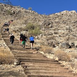
    Victory Steps at Verrado is a great workout. There are about 300 steps and a lot of people do…read moremultiple rounds, but it actually felt a little shorter than I expected. Still a solid climb with really nice views at the top. The hike is rated moderate to difficult compared to the other mountain trails in the area, but I felt it leaned more toward moderate. The stairs themselves are uneven, which adds to the challenge. Some sections have double railroad ties so the step height changes, and there's often sand on the wood, so you do have to pay attention to your footing. It's not like running up a regular staircase with fixed intervals. Every step feels a little different, which keeps you engaged the whole way up. I wore athletic shoes and they were fine, but I would've been more comfortable in hiking boots since the trail portions have loose rock and uneven footing. If you need ankle support, boots are the way to go, although most people were wearing regular athletic shoes. Even in winter, I would suggest a hat, sunscreen and water. Access is easy and weekday parking was no problem. After doing the Verrado Steps, I took the Muck Trail to Muck Park, which turned the whole outing into a longer, more scenic loop. From the park, I walked back around to the parking area on the opposite side of the stairs. Altogether it came out to about 4 miles with great views, steady climbs, and fun variety between the stairs and trail. It's a really enjoyable moderate hike, easy to access, and a nice mix of stair work and desert trail. I'd absolutely do this loop again.

    The drive up to this location was beautiful! There's a golf course and some really nice houses in…read morethis area. Once you get there, you'll see the steps to the left and a parking lot shortly right after. Spaces are limited and it can get pretty busy on the weekends. We started off with run around the area then made our way up the steps to check out the view. It took us 9 minutes round trip to complete.

    Photos
    Victory Steps at Verrado
    Victory Steps at Verrado - Steps

    Steps

    Victory Steps at Verrado - My starting point to get to the top!

    See all

    My starting point to get to the top!

    Quartz Peak - View of the peak

    Quartz Peak

    5.0(5 reviews)
    71.9 km

    A difficult hike with amazing views! I loved this hike. It's a long way back to the trailhead from…read morethe road and there are places where having 4x4 or higher clearance would be nice, but I saw a Prius at the trailhead. There are workarounds. It's a long and steady climb, definitely one of the more challenging hikes in the west valley. The last little bit there's some scrambling to get to the peak. The views are amazing and the giant slabs of quartz are beautiful.

    For years, I had stared out at the Sierra Estrella mountains wondering if I'd ever get the chance…read moreto hike to the top of Quartz Peak. I'm a Civic owner, so as soon as I heard about the sand roads and necessity of a high clearance/4x4 vehicle, I thought the day would never come (there's no way I'm buying a gas guzzling Jeep with a 30-mi each way work commute lol). That is, until I met some other awesome hikers from the Valley and coordinated an epic carpool! We met up in downtown Phoenix and headed out in the Jeeps to Goodyear. After getting off the 10 and heading down Estrella/Rainbow Ranch roads for what seemed like a good while, along came the sand/dirt roads. And man did they live up to their reputation! Some super fun off-roading action ensued, and let's just say I was so glad I wasn't in my own little car. One of the hiking buddies advised that he once tried to get to the trailhead in his Dodge Caravan but got stuck in the sand and wrecked the transmission. Yikes! Once we got to the trailhead (obviously an adventure in and of itself), it was a steady 5-6 mile uphill climb to the summit. There are definitely some false Peaks to conquer along the way that are grueling physically and mentally; however, once you get to the last half mile or so, it's a fairly short scramble and totally doable. Once you get to the top, you are greeted by a fantastic view of West Valley, South Mountain, Four Peaks, the Supes, East Valley, and the vast desert to the southwest. The way down is easier on the cardio but harder on the knees due to loose rocks so watch your step and don't rush it. Your legs will probably be sore for the next day or two but it'll be accompanied by the feeling of accomplishment! I also recommend going with a group as I did. Strength and support in numbers people! Plus, you may meet someone new and make friends along the way! I'm not sure when I'll get the chance to hike Quartz Peak again, but now every time I look out to the west at it, the memories will never fade!

    Photos
    Quartz Peak - Rian and me at the top

    Rian and me at the top

    Quartz Peak - Quartz

    Quartz

    Quartz Peak - Rian

    See all

    Rian

    Casa Grande Mountain Park - Peart Trail

    Casa Grande Mountain Park

    3.6(10 reviews)
    136.8 km

    I stop at this park to hike with my dogs while driving to or from California. The entrance to the…read moretrailhead is off Exit 200 on I-10, right by Love's and easy to get in and out of. Parking is free. There is one porta-pot but no water, so make sure you bring your own. On the north end you hear train and interstate traffic. On the south side you hear firing range. The trails can be rocky at times. There are also vicious cholla off the trails. Watch where you place your feet! The trails themselves are nice. They are rated easy (green), moderate (blue) and hard (black). They are singletrack or wide and are color-coded. I like taking the easy Spine trail north as it gently goes uphill, then taking the moderate-to-hard Ridge trail back. Despite the name, the Ridge trail does not go to the top of the hill, but rather stays on the east side to prevent bullets from the southside firing range from going over. This is a lovely sunrise hike. It's best to hike or ride the trails early in the morning as there is no shade here and it can get hot by 10am. My one complaint is the many broken glass along the lower trails, especially around the East Butte trail, on the hill as well as along the wider jeep trails. This glass glistens in sunlight.This broken glass is unsafe for mountain bikers and people walking their dogs. People using this free resource should respect this land. I always come back to my van with a few beer bottles to recycle. Come on people, stop trashing our public parks!!! Dogs are allowed and must be onleash, but many people here walk their dogs offleash with no trouble. I also see mountain bikers here.

    Went on a hike with my partner and our dog the other day. We had high hopes but were pretty…read moredisappointed. We hiked all the way to the top of the mountain and we just felt it was a little depressing. It's not the most aesthetic trail by any means. It's right near some power plant which gave it an industrial vibe. The mountain was a straight incline on concrete. The very top was the best part, but I'm in no rush to hike here again.

    Photos
    Casa Grande Mountain Park - Peart Trail

    Peart Trail

    Casa Grande Mountain Park
    Casa Grande Mountain Park - Scenery

    See all

    Scenery

    Saddle Mountain - hiking - Updated October 2026

    Loading...
    Loading...
    Loading...