Reddish Knob Photos


More like Reddish Knob
Recommended Reviews - Reddish Knob
Start your review...

3 years ago


7 years ago
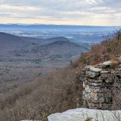
This place is absolutely beautiful. It has 360 degree views. The only down side is the road getting there is VERY narrow. About 1/3 of the drive is a one lane road with infrequent pull off areas to let other cars pass. Also, the higher you get the tougher the road gets with gravel and pot holes. read more


3 years ago
More info about Reddish Knob
North River
Reddish Knob, VA 22821
Directions
Hours
Outdoor Amenities


Reddish Knob - hiking - Updated July 2026
Best of Reddish Knob
People found Reddish Knob by searching for…
Things to Do in Reddish Knob, Virginia
Sunset View in Reddish Knob, Virginia
Watch Sunset in Reddish Knob, Virginia
Sunrise View in Reddish Knob, Virginia
Picnic Spots in Reddish Knob, Virginia
Beautiful Views in Reddish Knob, Virginia
Off Road Trails in Reddish Knob, Virginia
Hiking Trails in Reddish Knob, Virginia
Running Trails in Reddish Knob, Virginia
Picnic Areas in Reddish Knob, Virginia
Scenic View in Reddish Knob, Virginia
Lookout Points in Reddish Knob, Virginia
Swimming Holes in Reddish Knob, Virginia
Waterfalls in Reddish Knob, Virginia
Walking Trails in Reddish Knob, Virginia
Easy Hikes in Reddish Knob, Virginia
View Points in Reddish Knob, Virginia
Places to Take Pictures in Reddish Knob, Virginia
Picnic in Reddish Knob, Virginia
Sunset in Reddish Knob, Virginia
Jogging Trails in Reddish Knob, Virginia
Places to Run in Reddish Knob, Virginia
Browse Nearby
Browse Brands
Browse Articles
People who viewed Reddish Knob also viewed
Edith J. Carrier Arboretum - James Madison University
15 reviews
Natural Chimneys Regional Park
14 reviews
WILD GUYde Adventures
32 reviews
A Dream Come True Playground
17 reviews
Massanutten Village Family Entertainment Center
5 reviews
brandywine campground
1 review
Escapism Escape Rooms
15 reviews
Blue Ridge Axecade
3 reviews
Shenandale Gun Club
2 reviews
Gardigarci Breakpoint
1 review