Deerlick Trail Photos


More like Deerlick Trail
Recommended Reviews - Deerlick Trail
Start your review...

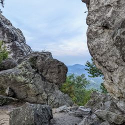
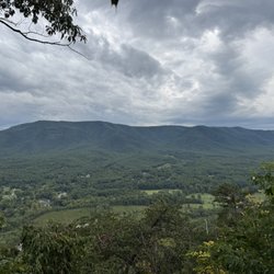
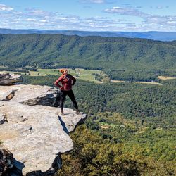
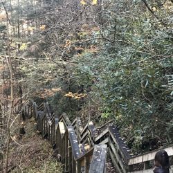
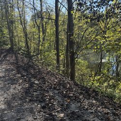
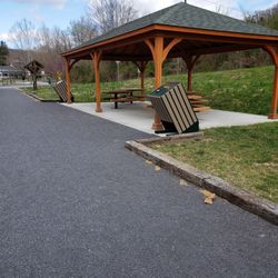
Joined the trail by crossing into "downtown" hot springs to the left of the Spa. Look for the stairs to the right of the corner restaurant caddy corner to the Homestead property. We walked up a short but steep path to a sign for "sunset overlook". Another short walk brought us to a a few benches in a clearing with a beautiful overlook of the Homestead. Overall, a nice relaxed 20 minute roundtrip walk for a great vista. read more

 - Hiking Near Me - Hot Springs, Virginia")
10 years ago
This trail starts on the grounds of The Homestead. From the valet entrance take a left on a side road that winds behind the kid's pool and water slides. Runs left by the golf course and across the grounds of The Homestead then crosses Sam Sneed Parkway into the woods behind the town. See my pics from Sunset Overlook. read more


5 years ago
More info about Deerlick Trail
7696 Sam Snead Hwy
Hot Springs, VA 24445
Directions
Hours
Outdoor Amenities


Deerlick Trail - hiking - Updated August 2026
Best of Hot Springs
People found Deerlick Trail by searching for…
Things to Do in Hot Springs, VA
Sunset View in Hot Springs, VA
Hiking Trails in Hot Springs, VA
Watch Sunset in Hot Springs, VA
Running Trails in Hot Springs, VA
Playgrounds in Hot Springs, VA
Scenic Overlook in Hot Springs, VA
Walking Trails in Hot Springs, VA
View Points in Hot Springs, VA
Lookout Points in Hot Springs, VA
Beautiful Views in Hot Springs, VA
Scenic Views in Hot Springs, VA
Water Parks for Kids in Hot Springs, VA
Off Road Trails in Hot Springs, VA
Hiking Trails Kid Friendly in Hot Springs, VA
Playgrounds for Kids in Hot Springs, VA
Photo Spots in Hot Springs, VA
Trending Searches in Hot Springs, VA
Browse Articles
Browse Nearby
BEST of Hot Springs, Virginia Waterfalls near Deerlick Trail
BEST of Hot Springs, Virginia Restaurants near Deerlick Trail
BEST of Hot Springs, Virginia Things to Do near Deerlick Trail
BEST of Hot Springs, Virginia Coffee near Deerlick Trail
BEST of Hot Springs, Virginia Swimming Holes near Deerlick Trail
BEST of Hot Springs, Virginia Breakfast near Deerlick Trail
BEST of Hot Springs, Virginia Ski Resorts near Deerlick Trail
BEST of Hot Springs, Virginia Caves near Deerlick Trail
BEST of Hot Springs, Virginia Campgrounds near Deerlick Trail
Browse Brands
Related Searches in Hot Springs, VA
Affordable Kayak Rental Services in Hot Springs, Virginia
Best Dog Hiking Trails Around Hot Springs, Virginia
Best Fishing Locations and Guides in Hot Springs, Virginia
Best Fun Things to Do in Hot Springs, Virginia
Best Places for Horseback Riding in Hot Springs, Virginia
Check Out Off Road Trails in Hot Springs, Virginia
Discover Dog Friendly Trails to Explore in Hot Springs, Virginia
Discover Popular Photo Spots in Hot Springs, Virginia
Discover a Hiking Trail in Hot Springs, Virginia
Discover the Best Night Hike Trails in Hot Springs, Virginia
Dog-Friendly Hikes With Dogs in Hot Springs, Virginia
Enjoy Off Leash Dog Hikes in Hot Springs, Virginia
Enjoy River Tubing Adventures in Hot Springs, Virginia
Enjoy the Best Tubing Experiences in Hot Springs, Virginia
Enjoy the Best Walking Trails in Hot Springs, Virginia
Exciting Things to Do in Hot Springs, Virginia Today
Experience Stunning Sunset Views in Hot Springs, Virginia
Explore Beautiful Parks and Green Spaces in Hot Springs, Virginia
Explore Bike Rentals Throughout Hot Springs, Virginia
Explore Easy Hikes Perfect for All in Hot Springs, Virginia
Explore Fun Activities to Do in Hot Springs, Virginia
Explore Landmarks & Historical Buildings in Hot Springs, Virginia
Explore Popular Boat Charters Near Hot Springs, Virginia
Explore Popular Campgrounds Near Hot Springs, Virginia
Explore Popular RV Parks Around Hot Springs, Virginia
Explore Popular Scenic Views Near Hot Springs, Virginia
Explore Popular View Points Around Hot Springs, Virginia
Explore Scenic Lakes to Visit in Hot Springs, Virginia
Explore Summer Camps for All Ages in Hot Springs, Virginia
Explore the Best Swimming Holes Around Hot Springs, Virginia
Family Friendly Hiking With Kids in Hot Springs, Virginia
Find Exciting Tours to Take in Hot Springs, Virginia
Find Popular Ziplining Spots Around Hot Springs, Virginia
Find Top-Rated Waterfalls in Hot Springs, Virginia Now
Find the Best Swimming Pools in Hot Springs, Virginia Today
Hiking Trails With Waterfalls in Hot Springs, Virginia
Off Leash Dog Hiking Trails in Hot Springs, Virginia
Plan a Scenic Drive Route Near Hot Springs, Virginia
Popular Kids Activities in Hot Springs, Virginia
Popular Picnic Spots to Visit in Hot Springs, Virginia
Popular Things to Do in Hot Springs, Virginia
Relax at Natural Hot Springs Near Hot Springs, Virginia
Tennis Courts and Clubs Near Hot Springs, Virginia
Top Hiking Trails to Explore in Hot Springs, Virginia
Top Things to Do With Kids in Hot Springs, Virginia
People who viewed Deerlick Trail also viewed
Douthat State Park
29 reviews
Greenbrier River Trail State Park
8 reviews
Dan Ingalls Overlook
5 reviews
George Washington National Forest
1 review
Droop Mountain Battlefield State Park
4 reviews
Let’s Ride Horses
13 reviews
Jackson River Trail
3 reviews
Greenbrier Bikes
7 reviews
Cliff View
5 reviews
Let's Ride Horses
1 review