Roaring Run Trail Photos


More like Roaring Run Trail
Recommended Reviews - Roaring Run Trail
Start your review...

Reviews With Photos

This was a nice and easy short hike along a stream. It was more of a stroll really. The scenery was serene and the running water provided a nice backdrop to listen to which was really soothing. The falls also provide a nice view. There was a place towards the end near the falls which was a good spot to picnic. Overall great hike not too strenuous and was very peaceful being a nature.


4 years ago
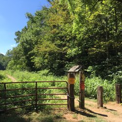
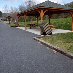
Tony and I went to Roaring Run Furnace In the Jefferson National Forest. This is a stone Built Pig Iron Furnace built in 1830. This 192 yr old construction is still standing and looks like they could just start using it again today The park was easy to find with GPS. It is free to enjoy. Plenty of parking and restrooms. Well marked trails. The Furnace is located about 500 feet from the parking lot and bathrooms. There is plenty of picnic tables and a creek for fishing and cooling off in warmer weather. There is also a waterfall to hike to!! Nice park and highly recommend especially for the historic value! Great day trip or field trip for home schooling!! read more


2 years ago
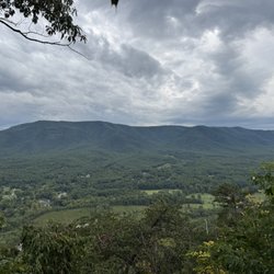
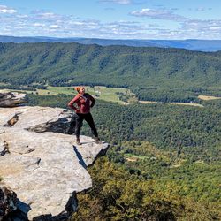
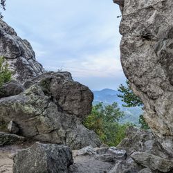
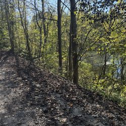
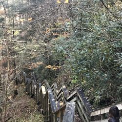
Roaring Run Trail is a gorgeous, moderate hike that takes you to the beautiful waterfalls at the end of the trail -- with plenty of other smaller waterfalls and wildlife to see along the way. If you do the loop-around, it's only a couple of miles round trip, but if you veer off before you complete the loop, you can keep going for another 7-8 miles. Although this hike is fairly moderate, it's what I credit giving me some experience in a little rock climbing -- which I used when I started hiking Devil's Tooth. I think a couple of my photos show it -- but at the end of the trail when you are finally at the big waterfall, there are rocks leading up to the top of it. Those are climbable, but you have to be careful and have good hiking boots on because they are very slippery - especially in the winter. If you can get yourself up there, it really is amazing to be on top of the waterfall looking down. I like to "perch" there for a little while before climbing down and continuing on. If you have tolerant younger children, they would probably enjoy the shorter couple mile version of the hike. However, I wouldn't recommend making them trudge along for the rest of it, as it would probably lose their attention pretty quickly without a small, new waterfall to see every quarter of a mile like on the main part of the trail. Overall, its a gorgeous and relaxing hike - especially in the fall and in the winter when the trees are beginning to lose their leaves and the mountain tops can be seen more easily. Most times the trail isn't very busy, and fellow hikers are often acknowledged with a smile or a nod. ***6 Photos*** read more


10 years ago
This was a nice and easy short hike along a stream. It was more of a stroll really. The scenery was serene and the running water provided a nice backdrop to listen to which was really soothing. The falls also provide a nice view. There was a place towards the end near the falls which was a good spot to picnic. Overall great hike not too strenuous and was very peaceful being a nature. read more

12 years ago
Roaring Run is my favorite trail for an easy-moderate hike with stunning glimpses of nature along the way. The path and foot bridges are nicely maintained. The shorter loop is appropriate for children, especially walking the stream-side trail to the falls and straight back. read more

6 years ago
11 years ago
Very Good Hike, however short. But family/Couple fun and good for walking pets! Beautiful views and fun for kids to swim, however can be dangerous! read more

More info about Roaring Run Trail
Ask the Community - Roaring Run Trail


Roaring Run Trail - hiking - Updated June 2026
Best of Eagle Rock
People found Roaring Run Trail by searching for…
Things to Do in Eagle Rock, Virginia
Fishing in Eagle Rock, Virginia
Hiking Trails With Waterfalls in Eagle Rock, Virginia
Photo Spots in Eagle Rock, Virginia
Rock Climbing in Eagle Rock, Virginia
Secret Spots in Eagle Rock, Virginia
Waterfalls in Eagle Rock, Virginia
Scenic Views in Eagle Rock, Virginia
Running Trails in Eagle Rock, Virginia
Parks for Kids in Eagle Rock, Virginia
Scenic Overlook in Eagle Rock, Virginia
Walking Trails in Eagle Rock, Virginia
Beautiful Views in Eagle Rock, Virginia
Picnic Spots in Eagle Rock, Virginia
Easy Hikes in Eagle Rock, Virginia
Hiking With Kids in Eagle Rock, Virginia
Fun Things to Do With Kids in Eagle Rock, Virginia
Sunrise View in Eagle Rock, Virginia
Picnic Areas in Eagle Rock, Virginia
Places to Walk Around in Eagle Rock, Virginia
Browse Brands
Browse Articles
People who viewed Roaring Run Trail also viewed
Douthat State Park
28 reviews
Greenbrier River Trail State Park
8 reviews
Caverns At Natural Bridge
28 reviews
Natural Bridge State Park
33 reviews
Jackson River Trail
3 reviews
George Washington National Forest
1 review
H & H Outdoors
2 reviews
Virginia Safari Park
307 reviews
Middle Creek Campground
1 review
Dinosaur Kingdom II
44 reviews