Ponderosa Campground Photos


You might also consider
More like Ponderosa Campground
Recommended Reviews - Ponderosa Campground
Start your review...

Reviews With Photos
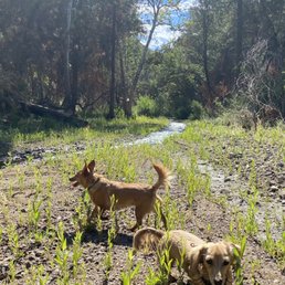
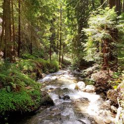
We had a great weekend. The host Andreas was amazing,helpful,and just a really cool guy. It was quiet here and we took the dogs now to the stream they loved it. You have no shower so we bring out solar shower. Bring a lot of water best site for tent camping I think is 23. For RV we had 20 which was perfect. No cell service so unplug and relax.

Booked this spot just a few weeks before so there were still spots open for reservation. Based on recent reviews, there seems to be some confusion about the reservation stuff. There are no free campsites near Big Sur, this campsite is great if you're looking for a cheaper campsite near Big Sur from what I could fine. I booked via recreation.gov for $33 on a Wednesday in August. According to this website, almost all the campsites are booked via reservation, and very few campsites are first come first serve within Ponderosa. When driving up, the sign for the campground said "No Vacancy", thus the owners expect all who drive up to be a registered guest. My only registration issue was that my name was not booked under my campsite, only the first letter of my last name which was confusing for both me and the 2 folks who run the campground (despite my full name being registered with the website). Yes there are no flushing toilets, however the spigots did in fact work despite some of the older reviews. There were no sinks, so we used the spigots and brought our own handsoap. The water temperature was dependent on the weather and the water had a bit of a sulfur smell (kinda eggy). Since it was summer, the creek was just about dried up to small puddles. There were some bugs, but since I did not stay near the creek so none were mosquitoes for me. I only ended up with a few ankle bites but none were itchy to me and that's just a forest camping norm. Besides these few issues, I love the privacy of the campsite I was at (15). Although there were a few upward steps, the spot was all under trees for shade and each site has a picnic table, grill, and fire pit. The grill did look old and gross, however we brought our own quick food to make in a cooler. Some of the other campsites along Big Sur do not offer the same privacy away from other campground/campers. Check in was at 3pm, however I arrived an hour early and others at the neighboring campsites arrived later from 5-6pm.

As far as campsites go, this place was okay! I agree with the other two reviewers....be prepared for a super windy drive up a very narrow road with no guard rails. I about literally peed my pants and died coming up this road and I am not afraid of heights. It's very steep and nothing between you and death! If you are not careful, one false move and you and your car are over a cliff to your home in Heaven. I am not joking around...this road is very dangerous! There are two ways to get to Ponderosa Campground. You can take the less windy road from 101 or take the more scenic but dangerous road from Hwy 1. From any direction from Hwy 1, take the Nacimiento-Ferguson Road drive and hold on tight for the next 13 miles inland. Don't take a wrong turn like we did...yikes! It was awful...and don't follow Mapquest.com directions or you will be taken to a pretty scary part of the mountain. The campground itself is small...only 22 campsites but it is quiet and the sites themselves are very spacious. We did not feel cramped with our 7 friends and 4 tents at our campsite. They each have a fire pit, picnic table and plenty of parking. The guy managing the camp site is super cool and friendly and there to answers questions. Water spicket was few and far between. We had to walk pretty far from our campsite just to get water. Bathrooms are close by but they are more like an outhouse. No mirrors, flush toilet, ventilation....just plug your nose and go! If you do come here in the winter, you are required to bring your own water as they do not provide water in the winter time. Bring bug spray....lots of bees, flies that love food! There apparently is a river near by, but I never saw it. I believe it was all dried up this weekend. It's very dry here. I might be back but I have experienced better more beautiful campsites in Big Sur that I would head to first before coming back to Ponderosa.

******PROS Pretty - Beautiful hills all around . Located in a small valley. Close to Mission San Antonio de Padua Stream - Runs through about half of the campsites. But when I was there in July the stream was only a trickle. Campsites - Most campsites are very spaced out and each has a table, grill, and fire pit. ******CONS Flies - There is an abundance of flies. They like to swarm in great numbers around your face in the morning and evening and seem to leave your food alone. Not the normal house fly, they are slightly smaller. Fly traps and bug spray didn't help, the smoke from our camp fire is the only thing that got them to go away. Road - The road from Ponderosa to the ocean is very windy, steep, narrow and theres no center divide. Google maps says it takes 30 minutes to get to Big Sur from Ponderosa but it takes longer. No Running Water - There are water spigots but they don't work. No running water anywhere in the campground. Pit Toilets Heat - It can get up to 100 degrees in the summer ******TIPS No Cell Service - The closest service I could get was at Mission San Antonio de Padua a half hour away and an hour north on highway 1. This means no GPS so have a map handy. Army Base - If your coming from the east (near mission) you will drive through Fort Hunter Ligget. It is open to through traffic. Go the speed limit or you may get a $200+ ticket from the military police. Watch out for wild boar and squirrels in the road. Fill Up On Gas and Groceries - Gas on highway 1 is $6+ a gallon, 1 small bottle of water is $4. Stores and gas are very expensive and few and far between.

8 months ago
Terrible experience going to this campground. I booked this site a month in advance. I ended up changing my camp site to a site deeper into the loop which I was charged additionally for. Upon arriving (after 5 hours and 300 miles of travel) I discover my campground is closed off. All surrounding campgrounds are either closed off due to "hazardous tree" or "reserved". So I was at a loss, no reception, no one there, no note left behind for my reservation that is unavailable. So I set up shop at site 14 and hope whoever shows up will share the campsite. Now I'm setting up my tent and I'm literally being swarmed by black gnats. Idk what they are because my citronella candle and dousing of mosquito spray is not working, not at all. After 3 hours of sitting like a duck and not seeing a single other person arrive to this campsite, I figured I couldn't stay alone in this abandoned campground. Over 22 sites here and only myself and a couple in site 1 which is upfront of the entrance were there. However their site shows most of the sites reserved. Unsure why people would choose to visit this campground besides its remoteness. Personally I can't say I recommend this place especially if you're traveling from some ways away. This is why I wrote Thai review. Unfortunately I couldn't in their website and I did not want someone else to have the experience I had. read more


I absolutely love Ponderosa Campground. There are no running water facilities, meaning no showers and just pit toilets. We got any water we needed that we did not carry with us from the spigots placed throughout the campground. One of my friends and I came here as part of a California Road Trip in mid-July 2018 (we were living in East Bay at the time - both of us in Albany) and this was our last campground before returning to the Bay Area. We had found most campgrounds were full up, but managed to find Ponderosa Campground with open spots online before making our way here by car. The drive in from the Southeast was through heathland with areas that had experienced burns/fires in the not too distant past. We also drove through Fort Hunter-Liggett, which we did not learn until driving through was in active use by the military. I even had to pull my tiny 2010 Toyota Corolla off to the side of the road to let the military vehicles, including tanks, drive past going the other direction. Careful to not pull off too far or get out of one's car and walk around if you need to pass through there, there were explosives in the ground... literally... We returned to the Fort area briefly after checking in to our campsite to contact our family/friends and let them know we were safe. At the campground itself we did not have cell phone reception and there were zero campground lights. Perfect for if you want to watch the stars at night. Just be careful and don't spook those mountain lions (also called cougars or pumas) into following you when you go to use the pit toilets at night. I found them to be quite friendly if treated kindly and not provoked. The campsite we used had a picnic table, parking space, and a fire pit which we couldn't use due to fire danger. Our site was flat, which was perfect for setting up the tent and playing a board game (Trivial Pursuit) by lantern light at night. The trees were tall and magical, as was the heathland outside of the campground on our drive in. Other campers were respectful and not too noisy, we tried to be quiet as well. All around a great stay I would say. read more

8 years ago
One of the best campgrounds around big sur. If you want to camp for the sake of Instagram and Facebook posts, this place is not for you. It's not fair giving it 2-3 stars because of bugs and cell phone service. This is REAL CAMPING. It's about 15 miles away from civilization. Make sure to have sufficient gas for the drive. Carry water for drinking and cleaning. And carry sufficient firewood (the campground host is not always around, especially in winter). The campground has pit toilets. There's a stream flowing around the campground. Great location to view the night sky and Milky Way. Another great thing about this campground is that it's usually available during long weekends as well. My go to campground for a last minute plan. read more


5 years ago
We had a great weekend. The host Andreas was amazing,helpful,and just a really cool guy. It was quiet here and we took the dogs now to the stream they loved it. You have no shower so we bring out solar shower. Bring a lot of water best site for tent camping I think is 23. For RV we had 20 which was perfect. No cell service so unplug and relax. read more


Booked this spot just a few weeks before so there were still spots open for reservation. Based on recent reviews, there seems to be some confusion about the reservation stuff. There are no free campsites near Big Sur, this campsite is great if you're looking for a cheaper campsite near Big Sur from what I could fine. I booked via recreation.gov for $33 on a Wednesday in August. According to this website, almost all the campsites are booked via reservation, and very few campsites are first come first serve within Ponderosa. When driving up, the sign for the campground said "No Vacancy", thus the owners expect all who drive up to be a registered guest. My only registration issue was that my name was not booked under my campsite, only the first letter of my last name which was confusing for both me and the 2 folks who run the campground (despite my full name being registered with the website). Yes there are no flushing toilets, however the spigots did in fact work despite some of the older reviews. There were no sinks, so we used the spigots and brought our own handsoap. The water temperature was dependent on the weather and the water had a bit of a sulfur smell (kinda eggy). Since it was summer, the creek was just about dried up to small puddles. There were some bugs, but since I did not stay near the creek so none were mosquitoes for me. I only ended up with a few ankle bites but none were itchy to me and that's just a forest camping norm. Besides these few issues, I love the privacy of the campsite I was at (15). Although there were a few upward steps, the spot was all under trees for shade and each site has a picnic table, grill, and fire pit. The grill did look old and gross, however we brought our own quick food to make in a cooler. Some of the other campsites along Big Sur do not offer the same privacy away from other campground/campers. Check in was at 3pm, however I arrived an hour early and others at the neighboring campsites arrived later from 5-6pm. read more

7 years ago
As far as campsites go, this place was okay! I agree with the other two reviewers....be prepared for a super windy drive up a very narrow road with no guard rails. I about literally peed my pants and died coming up this road and I am not afraid of heights. It's very steep and nothing between you and death! If you are not careful, one false move and you and your car are over a cliff to your home in Heaven. I am not joking around...this road is very dangerous! There are two ways to get to Ponderosa Campground. You can take the less windy road from 101 or take the more scenic but dangerous road from Hwy 1. From any direction from Hwy 1, take the Nacimiento-Ferguson Road drive and hold on tight for the next 13 miles inland. Don't take a wrong turn like we did...yikes! It was awful...and don't follow Mapquest.com directions or you will be taken to a pretty scary part of the mountain. The campground itself is small...only 22 campsites but it is quiet and the sites themselves are very spacious. We did not feel cramped with our 7 friends and 4 tents at our campsite. They each have a fire pit, picnic table and plenty of parking. The guy managing the camp site is super cool and friendly and there to answers questions. Water spicket was few and far between. We had to walk pretty far from our campsite just to get water. Bathrooms are close by but they are more like an outhouse. No mirrors, flush toilet, ventilation....just plug your nose and go! If you do come here in the winter, you are required to bring your own water as they do not provide water in the winter time. Bring bug spray....lots of bees, flies that love food! There apparently is a river near by, but I never saw it. I believe it was all dried up this weekend. It's very dry here. I might be back but I have experienced better more beautiful campsites in Big Sur that I would head to first before coming back to Ponderosa. read more


10 years ago
******PROS Pretty - Beautiful hills all around . Located in a small valley. Close to Mission San Antonio de Padua Stream - Runs through about half of the campsites. But when I was there in July the stream was only a trickle. Campsites - Most campsites are very spaced out and each has a table, grill, and fire pit. ******CONS Flies - There is an abundance of flies. They like to swarm in great numbers around your face in the morning and evening and seem to leave your food alone. Not the normal house fly, they are slightly smaller. Fly traps and bug spray didn't help, the smoke from our camp fire is the only thing that got them to go away. Road - The road from Ponderosa to the ocean is very windy, steep, narrow and theres no center divide. Google maps says it takes 30 minutes to get to Big Sur from Ponderosa but it takes longer. No Running Water - There are water spigots but they don't work. No running water anywhere in the campground. Pit Toilets Heat - It can get up to 100 degrees in the summer ******TIPS No Cell Service - The closest service I could get was at Mission San Antonio de Padua a half hour away and an hour north on highway 1. This means no GPS so have a map handy. Army Base - If your coming from the east (near mission) you will drive through Fort Hunter Ligget. It is open to through traffic. Go the speed limit or you may get a $200+ ticket from the military police. Watch out for wild boar and squirrels in the road. Fill Up On Gas and Groceries - Gas on highway 1 is $6+ a gallon, 1 small bottle of water is $4. Stores and gas are very expensive and few and far between. read more


8 years ago
16 years ago
Pros: Available "walk-ups" year round. Beautiful stream running through the campground. Budget friendly - $15 per night Quiet Cons: BUGS, bugs, bugs - they wont leave you alone Outhouse with no running water - plug your nose, cuz it is a hole in the ground. Water spigots at each campsite DO NOT WORK - bring your own water. Scary (yet scenic) drive up the mountain. No cell phone service - or electricity for that matter - or sewer - or showers! Reserve America does a poor job of explaining how "rough" this "roughing it" experience is going to be. I don't mind sleeping in a tent, packing in food, and smelling like campfire. However, I do like a toilet that works, a shower (even if I have to pay to use it), and running water that I can drink from and wash my dishes from. The single water spigot at the entrance is only for drinking... how do they expect you to pack everything in, but not be able to clean any of it?! The bugs made it impossible to stay more than one night. I assume that the bugs come from the open outhouse?! The stream could also be the cause.... Regardless of what causes them, there are BUGS BUGS BUGS - Bugs in your food, bugs in your drinks, bugs in your clothes, bugs climbing all over your tent.... Too bad the place is beautiful, otherwise I would give it 1 star. read more


14 years ago
14 years ago
8 years ago
17 years ago
16 years ago
11 years ago
6 years ago
15 years ago
8 years ago
8 years ago
14 years ago
8 years ago
9 years ago
9 years ago
12 years ago
13 years ago
16 years ago
15 years ago
16 years ago
8 years ago
9 years ago
16 years ago
11 years ago
15 years ago
16 years ago
had a good time yes the road was crazy driveing up but worth it !!! poison oak is varry bad but just stay out of it lol and you will be fine the river lol is not a river its a brook but well stocked with fish !! i stayed three days had a good time !! the bearded camp host was good help and a nice guy had a few beers with him after he got off work nice story teller !!!! and full of info about the campground and the army base thats next to it ! bugs bugs bugs yes but i found if you light and keep a small fire in you camp all day long you will not have a big problem with then at all !!!!! o yea bring fire wood with you theres not much in the way of wood to fined !! thay sell it but its 5 bucks for a small amount of wood you need more so bring it with you !!!!!!!all and alll good place to camp get walk in spot #5 and you will have the brook right behind you i cought lots of fish there have fun!!!!!!! read more


More info about Ponderosa Campground
Nacimiento-Fergusson Rd
Big Sur, CA 93920
Directions
(877) 444-6777
Call Now
Visit Website
http://campone.com
Hours
Outdoor Amenities
Other Amenities
Ask the Community - Ponderosa Campground
Review Highlights - Ponderosa Campground
You might also consider


Why does Yelp recommend reviews?
1 review that is not currently recommended
The reviews below are not factored into the business's overall star rating.
7 years ago
Ponderosa Campground - hiking - Updated May 2026
Best of Big Sur
People found Ponderosa Campground by searching for…
Swimming Holes in Big Sur, California
River Swimming in Big Sur, California
Redwood Trees in Big Sur, California
Free Campgrounds in Big Sur, California
Trout Fishing in Big Sur, California
Hiking Trails With Waterfalls in Big Sur, California
Dog Friendly Hiking Trails in Big Sur, California
Camping & Campsites in Big Sur, California
Beaches in Big Sur, California
Star Gazing in Big Sur, California
River Tubing in Big Sur, California
Beach Camping in Big Sur, California
Off Road Trails in Big Sur, California
Things to Do in Big Sur, California
Fishing in Big Sur, California
Secluded Spots in Big Sur, California
Camping Cabins in Big Sur, California
Camping Sites in Big Sur, California
Scenic View in Big Sur, California
River Access in Big Sur, California
Tent Camping in Big Sur, California
Points of Interest in Big Sur, California
Browse Brands
Related Cost Guides
Browse Articles
People who viewed Ponderosa Campground also viewed
Arroyo Seco Campground
143 reviews
San Simeon State Park & Campground
157 reviews
Plaskett Creek Campground
99 reviews
Lake Nacimiento Resort
234 reviews
Lake San Antonio
44 reviews
Yanks RV Resort
116 reviews
Big Sur Riverside Campground
2 reviews
Cone Peak
4 reviews
Pine Valley
1 review
Native Hunt Enterprises
11 reviews