Partington Cove Photos


You might also consider
More like Partington Cove
Recommended Reviews - Partington Cove
Start your review...

Reviews With Photos

So, I had the pleasure of finally camping in Big Sur in February; I was ecstatic when my friend offered this charming little hike down to the mountainside, through a spooky bridge, to the end where waves crash at your feet. It's easy enough for a 4 year old hiker (in Cortez's), and I know because we did this little hike for Addie's 4th Birthday and she was indeed wearing Cortez's. I recommend going early, though. As we were finishing up our hike around 11, the couples and crowds were rolling in to sit by the crashing waves, and take turns weaving in and out of the tiny bridge to finish up the trail.

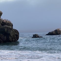
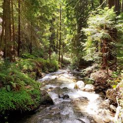
A must-do easy-to-miss hike. Photo ops include a small wooden bridge and the 60 foot graffiti-lined wooden tunnel carved by the guy for whom this is named: John Cove. No, wait, John Partington, who used this tunnel to transport oak to ships. When you reach the fork, pick it up because littering sucks. And, when you reach a point at Partington Creek where the trail breaks off into two directions, know that the right goes north to a rocky beach, bypassing the bridge and tunnel. Either trail ends at the beautifully blue, remote, peaceful but rock-crashing cove itself, lined with picturesque tiers of rocks you'll be tempted to scramble across despite warnings from the parks dept. The 1.1 mile trail is ranked Moderate only because the wide dirt wagon trail can be steep, making it hard if your view was already breathtaking enough. A popular website that serves as some sort of advisor for trips ranks this #10 of 40 things to do in BIg Sur. Though it's part of the Julia Pfeiffer Burns State Park, the small official parking lot is two miles south of the trail, so it's best to park near the green gated fire road on the westside of PCH. [36.1770, -121.6937]. Open til sunsets, and according to the warning signs, this would be a particularly bad place to bring a dog in a tent set on fire.

My fiancé and I planned a short day trip to Big Sur and wanted to see some nice new views. We've made a few trips to the area in the past, and have already checked off the big ticket spots like McWay Falls and Pfeiffer Beach. A quick search on Yelp brought me Partington Cove, and I'm glad it did. GPS took us directly to the entrance off Hwy 1 (make sure you pre-load it before you lose phone signal). It's a short, easy-to-follow hike down with 2-3 switchbacks. One side of the trails takes you down to some huge rocks on the water, where you can just hang out and listen to the water. We even saw a lady casually doing yoga on the rocks! The other side takes you across a bridge, under a tunnel, and to a nice cliff with gorgeous views of that BLUE California water. I could sit and stare at those bright hues for hours. But honestly, if you just wanted to walk to both ends of the trails at Partington and get back to your car without stopping to look at the views, you'd probably be done in 30 minutes. Most people were wearing masks. I saw more than a handful of dogs, even though the signs explicitly say they're off limits. Just don't be like one of the families we saw that were maskless, walking their dog, and one of them was smoking....triple whammy :(

What a nice surprise! We noticed some cars parked along Hwy. 1 and decided to pull over and take a look. There is no highway sign for Partington Cove, but when you get past the gate and when you get on the trail, the sign is posted. The trail is a big descent down the hill. When you get to the bottom of the hill, the trail splits. You can go on the bridge, walk through a cave which takes you towards the cove. If you go to the right of the bridge, there is a smaller trail along the creek that takes you towards the rocks. We stopped for a few minutes to take in a shady area to listen to the creek and watch the water before sitting on the large rocks and watch the waves. There is another trail to the left of the bridge, but it gets dark/shady and dead ends. Stick with the other two trails. Some people wore masks, others did not (i.e., a multi-family group), but we were able to maintain our social distancing. We were there on a Monday, so it wasn't as crowded as it might be on a weekend day. No dogs are allowed on the trail, but some people brought Fido anyways. If you are going to do that, please pick up after your pet out of courtesy for the rest of us. That doesn't mean it's okay bring a doggie bag and leave it on the trail (yep, someone did that). This is worth checking out. Don't let the giant descent/ascent of the hill deter you.

A little hike along Big Sur... There was no clear sign for the Partington Cove but in researching it I knew it would be a little hike down to see the views of the coast. After parking, we found the metal gate on the ocean side of Highway 1. Our hint was all the cars parked near it. The hike down to see the views is steep but to the experienced hiker this would be nothing. There are two crossroads to this hike. The first one took us straight to short trail heads off to the left past a kiosk. There is an interpretive sign for cool educational reading about the sea life just offshore. This short stop is picturesque with views of waves crashing into big rocks and follows Partington Creek a little ways up until the large rocks and plants would block further progress. We didn't go that far though. This was a quick stop for us. We headed to another path for the second junction. The second hike was a little bit further going through a wooden bridge and a tunnel. The mouth of the tunnel took us through the ridge to the cove. The tunnel is tall enough inside for an average person to walk upright. We hiked a little bit more until we saw large boulders and plenty of folks chillaxing soaking in the picturesque scenery. There is also a nice bench to enjoy the view but someone was hogging it while we were there. This was the end of the hike and it was time to think about the steep walk back up to the highway. LoL ugh, ouch, sore and out of breath by the time we reached the highway. We were so out of shape :/ Review #1691


So underrated, but a must visit! I decided to visit Partington Cove after seeing some nice pictures online during my pre-trip research. I had brought this up to a ranger? at the visitor center and he gave me a weird look so I had low expectations for this place. But I'm so glad we went anyway. Free parking on the side of the highway! Once you park, you'll see the trail head, which is a green gate that prevents cars from going down (I almost thought the trail was closed completely). All you need to do is go around the gate and you'll be on your way down to the cove. It's not a long trail but it is relatively steep (especially on the way up!) but it's worth it! The cove itself is very pretty. The water near the actual cove is a beautiful clear green and as you go further out, the water becomes a nice blue colour. We were lucky to go on a day with good weather and the sky was amazing! Sit in a shady area on the rocks - it is a perfect spot to take a break and just soak in the beauty of nature ^^ Honestly, you can bring some snacks and have a super fun picnic too. Highly recommend!

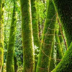
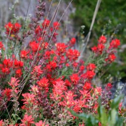
Don't miss this place! There's no sign for it from Highway 1 so plan accordingly with your GPS so you don't miss it. There are only a few places in the Big Sur area that allow you access to the ocean, this is one of them! You descend down until you come to an area where the trail splits, over a cute little bridge. I recommend checking out both sides. One will take you into a tunnel to an area where you can actually swim. (very rocky area so not recommended for all) The water is spectacular! So blue.... The other one will take you to a similar area where you can explore sea life that live on the rocks. There isn't a beach here because it's so rocky but you can still navigate your way to the water if you choose to do so. Swimming here can become dangerous when the ocean gets rowdy so I recommend you go to an actual beach (Pfeiffer Beach) if you'd like to swim or have younger children with you. This trail is incredibly lush with all sorts of flowers. It's beautiful and not too many people seem to know about it. Take advantage of that before that changes!

Nice hike that splits at the bottom of the trail. Take the time to explore both routes and you'll enjoy two beautiful experiences. The path to the right brings you to a granite boulder beach, crashing waves, and a view of the endless Pacific. Backtrack and take the wooden bridge route and you'll pass through a short tunnel through the mountain to a walkway that ends in a bench for viewing another amazing Pacific vista. This is a very rewarding hike.

Wow, we've been to Big Sur many times over the past 10 years and have never been here until today. We hiked down to the fork in the road, went to the rocky beach and also through a tunnel to another cove. Fun times and an easy walk down the hill. Going back uphill was a bit tougher but we managed. :) Even 5 year olds can do this hike, it's pretty easy. Gorgeous views at the end and there's even a bench to sit in at the end of the tunnel trail. We parked on the side dirt area in front of the trail entrance. Would recommend this trail to anyone coming through Big Sur and has at least 1 hour to spare!

Absolutely gorgeous! Two paths, one to the left with a bridge that take you by stream, and then to a more sharp rocky area with some very strong waves, and the other has more round smooth rocks and a small water fall/ stream that goes into the ocean. Not to crazy long of a hike of you are short on time, but interesting enough where you can explore a lot if you want to take longer. The incline also gives you a nice work out on the way back up. We parked along the shoulder of the road.


Our twelfth stop (09:42) on the Cabrillo Highway on our southbound trip through Big Sur, this dirt turn off provides unmarked parking to get clear views of the Partington Cove trail that will take you down to see the cove. We couldn't take the hike down but there were already cars parked on the side of the road to allow easy entry onto the trailhead. No cell reception in this area. read more


We came here 10 years ago and it was a hidden gem at the time, we drove by around 8:30am on the way to McWay Falls and there were already 2 cars there so I knew it was no longer a secret. This is by far one of our favorite Big Sur spots. The entire beginning of the hike is all downhill so you'll have an easy time going down and be panting on the way back up, you'll see it in other people's faces as you are going down. At the very bottom split I would take the time to go both directions, if you take the bridge it'll lead to a view of the ocean that narrows and then broadens. There is a nice wood tunnel you'll pass through and at the very end of the trail you can do a small rock scrambles to get an amazing view of the turquoise blue water and seaweed gently swaying in the water. If you are lucky you'll spot some sea otters diving in the kelp. If you take the other path it leads to a rocky cove with fun boulders for kids and adults to climb on, if you come in a wet season or after rain there will be a stream with many mini waterfalls on the left side. The wave splashes here are epic and it is dangerous so I would always be mindful of the water and avoid rocks that are wet when visiting. read more


5 months ago
So, I had the pleasure of finally camping in Big Sur in February; I was ecstatic when my friend offered this charming little hike down to the mountainside, through a spooky bridge, to the end where waves crash at your feet. It's easy enough for a 4 year old hiker (in Cortez's), and I know because we did this little hike for Addie's 4th Birthday and she was indeed wearing Cortez's. I recommend going early, though. As we were finishing up our hike around 11, the couples and crowds were rolling in to sit by the crashing waves, and take turns weaving in and out of the tiny bridge to finish up the trail. read more


A must-do easy-to-miss hike. Photo ops include a small wooden bridge and the 60 foot graffiti-lined wooden tunnel carved by the guy for whom this is named: John Cove. No, wait, John Partington, who used this tunnel to transport oak to ships. When you reach the fork, pick it up because littering sucks. And, when you reach a point at Partington Creek where the trail breaks off into two directions, know that the right goes north to a rocky beach, bypassing the bridge and tunnel. Either trail ends at the beautifully blue, remote, peaceful but rock-crashing cove itself, lined with picturesque tiers of rocks you'll be tempted to scramble across despite warnings from the parks dept. The 1.1 mile trail is ranked Moderate only because the wide dirt wagon trail can be steep, making it hard if your view was already breathtaking enough. A popular website that serves as some sort of advisor for trips ranks this #10 of 40 things to do in BIg Sur. Though it's part of the Julia Pfeiffer Burns State Park, the small official parking lot is two miles south of the trail, so it's best to park near the green gated fire road on the westside of PCH. [36.1770, -121.6937]. Open til sunsets, and according to the warning signs, this would be a particularly bad place to bring a dog in a tent set on fire. read more


 - Hiking Near Me - Big Sur, California")

6 years ago
My fiancé and I planned a short day trip to Big Sur and wanted to see some nice new views. We've made a few trips to the area in the past, and have already checked off the big ticket spots like McWay Falls and Pfeiffer Beach. A quick search on Yelp brought me Partington Cove, and I'm glad it did. GPS took us directly to the entrance off Hwy 1 (make sure you pre-load it before you lose phone signal). It's a short, easy-to-follow hike down with 2-3 switchbacks. One side of the trails takes you down to some huge rocks on the water, where you can just hang out and listen to the water. We even saw a lady casually doing yoga on the rocks! The other side takes you across a bridge, under a tunnel, and to a nice cliff with gorgeous views of that BLUE California water. I could sit and stare at those bright hues for hours. But honestly, if you just wanted to walk to both ends of the trails at Partington and get back to your car without stopping to look at the views, you'd probably be done in 30 minutes. Most people were wearing masks. I saw more than a handful of dogs, even though the signs explicitly say they're off limits. Just don't be like one of the families we saw that were maskless, walking their dog, and one of them was smoking....triple whammy :( read more


 - Hiking Near Me - Big Sur, California")

 - Hiking Near Me - Big Sur, California")

6 years ago
What a nice surprise! We noticed some cars parked along Hwy. 1 and decided to pull over and take a look. There is no highway sign for Partington Cove, but when you get past the gate and when you get on the trail, the sign is posted. The trail is a big descent down the hill. When you get to the bottom of the hill, the trail splits. You can go on the bridge, walk through a cave which takes you towards the cove. If you go to the right of the bridge, there is a smaller trail along the creek that takes you towards the rocks. We stopped for a few minutes to take in a shady area to listen to the creek and watch the water before sitting on the large rocks and watch the waves. There is another trail to the left of the bridge, but it gets dark/shady and dead ends. Stick with the other two trails. Some people wore masks, others did not (i.e., a multi-family group), but we were able to maintain our social distancing. We were there on a Monday, so it wasn't as crowded as it might be on a weekend day. No dogs are allowed on the trail, but some people brought Fido anyways. If you are going to do that, please pick up after your pet out of courtesy for the rest of us. That doesn't mean it's okay bring a doggie bag and leave it on the trail (yep, someone did that). This is worth checking out. Don't let the giant descent/ascent of the hill deter you. read more


A little hike along Big Sur... There was no clear sign for the Partington Cove but in researching it I knew it would be a little hike down to see the views of the coast. After parking, we found the metal gate on the ocean side of Highway 1. Our hint was all the cars parked near it. The hike down to see the views is steep but to the experienced hiker this would be nothing. There are two crossroads to this hike. The first one took us straight to short trail heads off to the left past a kiosk. There is an interpretive sign for cool educational reading about the sea life just offshore. This short stop is picturesque with views of waves crashing into big rocks and follows Partington Creek a little ways up until the large rocks and plants would block further progress. We didn't go that far though. This was a quick stop for us. We headed to another path for the second junction. The second hike was a little bit further going through a wooden bridge and a tunnel. The mouth of the tunnel took us through the ridge to the cove. The tunnel is tall enough inside for an average person to walk upright. We hiked a little bit more until we saw large boulders and plenty of folks chillaxing soaking in the picturesque scenery. There is also a nice bench to enjoy the view but someone was hogging it while we were there. This was the end of the hike and it was time to think about the steep walk back up to the highway. LoL ugh, ouch, sore and out of breath by the time we reached the highway. We were so out of shape :/ Review #1691 read more


7 years ago
So underrated, but a must visit! I decided to visit Partington Cove after seeing some nice pictures online during my pre-trip research. I had brought this up to a ranger? at the visitor center and he gave me a weird look so I had low expectations for this place. But I'm so glad we went anyway. Free parking on the side of the highway! Once you park, you'll see the trail head, which is a green gate that prevents cars from going down (I almost thought the trail was closed completely). All you need to do is go around the gate and you'll be on your way down to the cove. It's not a long trail but it is relatively steep (especially on the way up!) but it's worth it! The cove itself is very pretty. The water near the actual cove is a beautiful clear green and as you go further out, the water becomes a nice blue colour. We were lucky to go on a day with good weather and the sky was amazing! Sit in a shady area on the rocks - it is a perfect spot to take a break and just soak in the beauty of nature ^^ Honestly, you can bring some snacks and have a super fun picnic too. Highly recommend! read more


Don't miss this place! There's no sign for it from Highway 1 so plan accordingly with your GPS so you don't miss it. There are only a few places in the Big Sur area that allow you access to the ocean, this is one of them! You descend down until you come to an area where the trail splits, over a cute little bridge. I recommend checking out both sides. One will take you into a tunnel to an area where you can actually swim. (very rocky area so not recommended for all) The water is spectacular! So blue.... The other one will take you to a similar area where you can explore sea life that live on the rocks. There isn't a beach here because it's so rocky but you can still navigate your way to the water if you choose to do so. Swimming here can become dangerous when the ocean gets rowdy so I recommend you go to an actual beach (Pfeiffer Beach) if you'd like to swim or have younger children with you. This trail is incredibly lush with all sorts of flowers. It's beautiful and not too many people seem to know about it. Take advantage of that before that changes! read more


Nice hike that splits at the bottom of the trail. Take the time to explore both routes and you'll enjoy two beautiful experiences. The path to the right brings you to a granite boulder beach, crashing waves, and a view of the endless Pacific. Backtrack and take the wooden bridge route and you'll pass through a short tunnel through the mountain to a walkway that ends in a bench for viewing another amazing Pacific vista. This is a very rewarding hike. read more


Wow, we've been to Big Sur many times over the past 10 years and have never been here until today. We hiked down to the fork in the road, went to the rocky beach and also through a tunnel to another cove. Fun times and an easy walk down the hill. Going back uphill was a bit tougher but we managed. :) Even 5 year olds can do this hike, it's pretty easy. Gorgeous views at the end and there's even a bench to sit in at the end of the tunnel trail. We parked on the side dirt area in front of the trail entrance. Would recommend this trail to anyone coming through Big Sur and has at least 1 hour to spare! read more

Absolutely gorgeous! Two paths, one to the left with a bridge that take you by stream, and then to a more sharp rocky area with some very strong waves, and the other has more round smooth rocks and a small water fall/ stream that goes into the ocean. Not to crazy long of a hike of you are short on time, but interesting enough where you can explore a lot if you want to take longer. The incline also gives you a nice work out on the way back up. We parked along the shoulder of the road. read more


5 years ago
Definitely worth hike down to the water. You can get fairly close to the ocean if you hike out to the rocks. read more


6 years ago
If you only have time for one hike, I would highly recommend this one. Trail is just off Highway 1. The initial part is all descent without shade so keep that in mind as the way back will be more challenging. Near the bottom, if you stay to the right, you get to a beautiful cove where you can watch the waves crash over the rocks. If you go to the left, you go through a small tunnel to another gorgeous view of more calm waters. The hike itself is probably about 0.5-0.75 miles, but I would planning on spending about 1-2 hours there as it's such a peaceful place to relax. read more


4 years ago
This place is a little heaven on earth on the side of the freeway. It was my favorite spot driving in Hwy 1 through Big Sur. Cool trail, stunning views, rock climbing, tide pools, ocean caves, seal watching, and more. Did I stay stunning views?! read more


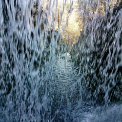
1 mile, moderate hike. Location: 2 miles north of Julia Burns main entrance there the highway dives inland around a side canyon. Park at a small dirt turnout on either side. Trail begins at a locked gate. Hike: The hike is all downhill into Partington Canyon where it splits into 2 short trails. To the right, you will see waves crash against a set of large rocks. There is also a stream of waterfall that lead into this cove. To the left, you will walk through 100 feet of rock, thanks to a historic tunnel built in the late nineteenth century by enterprising settlers. On the other side, you will get a beautiful view of the coastline. Note: There is no shade on the downhill or uphill on the way back. However, the incline is not too steep or slippery. read more


5 years ago
Absolutely beautiful location! 10 min walk max downhill from parking. Easy rock climbing which allows you to get to the cove from several points. Beautiful spot with blue blue water ! Would definitely come back again ! read more


5 years ago
An easy and short hike with spectacular views! It starts off with a steep downhill and then splits at the bottom. The left takes you through a short tunnel towards the cove -- the water had beautiful shades of blue & there was a comfy bench to sit at. The right takes you towards the rocks and is a great place to watch the crashing waves. Overall, highly recommend this trail! read more


unmarked gated trail, perhaps to keep out the non-locals? The parked cars on the side of the highway made us curious to stop. It was indeed Partington and the historic tunnel drilled through the mountainside to transport the lumber from from the moutains into the ships that pulled up to port here. Plently of rocks to climb out on and of course that attracts those into bouldering and rock climbing, seen a few of those hard core enthusiasts out this way (and none too friendly, as if they were disgusted by tourists.. haha, come on this is big sur, it's a place loaded with tourists, get over it) Nonetheless, it is perfect to climb out on some rock you can claim for yourself and stare into the crashing waves below, or admire the various layers of sediment in the rock formations, or to gaze as the setting sun over the horizon. read more


After reading the other reviews, i realized how luck we were to find this place on an empty weekend in Big Sur (Hwy 1 closed north and south). We were the only ones there and felt like we had the whole ocean to ourselves. Well, we did have to share it with an adorable otter and a seal, both of whom were about 20 feet from us (one in Partington Cove, one in the cove to the north) If you have the history of big sur coffee table book from Post Ranch, you can see a picture taken from the cliff to the left of Partington Cove and you can match it up the current cove perfectly (the base of the wooden hoist which they used to off-load ships in the early days of Big Sur still remains on the rocks just past that pesky "do no cross, dangerous surf" sign.) However, I imagine that if we had to share that place with a dozen other people, or if it wasn't such a perfect sunny 73 degree day, it wouldn't have been so magical and those adorable sea critters wouldn't have been so close to shore. Still, it's a great spot. read more


7 years ago
This gem of a view isn't publicly advertised, and there are no signs posted on how to get there. We found while doing an online search and easily located it due to the number of cars parked by fellow visitors. It's a short walk down, with a walk across a short, stable bridge, and through a tunnel. Once you reach the farthest point, you'll have stunning views! The walk back up will be slightly steep during a couple points. It's worth it! read more


BOO YAH, BIG SUR IS OFFICIALLY BACK IN BUSINESS BABY!!! A week ago, I probably would not have uttered such an exclamation. To be honest, I never really thought much about exploring Big Sur. Sure, I found it to be quite beautiful when I drove by last year on the way to Berkeley. But, back then I wouldn't have considered it a place you HAD TO visit before dying. That all changed last weekend when I decided to take my girlfriend to Big Sur for the first time since the area had finally reopened after months of construction. OMGEE I have never been so wrong in my life. Big Sur - from the gorgeous coastline views of the ocean to the windy and rewarding trails of its massive state parks - actually offers one of THE BEST escapes for people living in the Bay Area. If you had just one day and only one day to visit Big Sur, you HAVE to explore Partington Cove! My girlfriend and I took a chance with this place because apparently the view was "something out of a dream" (https://californiathroughmylens.com/big-sur-attractions). Even though it was a bit tricky to find to say the least, Partington Cove was definitely one of the most memorable moments of our trip. Here's why I think it needs to be on everyone's radar: -- GORGEOUS SCENERY -- Imagine yourself sitting on a wooden bench. The only things around you are massive, multicolored rocks and the occasional seagull that may swoop in for a light snack (not you hopefully!). You look into the distance and find yourself engulfed by sheer beauty: The clearest, bluest water is all around you - far as the eye can possibly see. You want to climb down into the cove and take a long swim, but the awe-inspiring view has got you caught in a daze. Think this is a dream? No, this is real life. THIS is Partington Cove. The pristine water, giant landscape, and calm shore...they all make it one of the most beautiful places in California. -- SIMPLE, YET ADVENTUROUS TERRAIN -- Getting to the cove from the trailhead is pretty easy. There is literally only one path that exists here, and it will take you directly to paradise. Starting from the top: Descend along Partington Cove Trail, go across the bridge at the bottom, and then hold your breath through the 60 foot tunnel until you enter into heaven. Easy right? It's only about a 15 minute walk at most. But, the amazing part is that the journey's ALMOST AS SPECTACULAR as the cove. Partington Trail is quite diverse, with the landscape constantly changing before your eyes. One minute you're hiking in the sun; the next, you're near a creek. And eventually, you're passing through a spooky tunnel! Who said short walks have to be boring? -- PRIVATE AND TRANQUIL -- Since the trailhead is difficult to spot (see below), many people either don't know about the cove or they drive past it without realizing. As a result, there will be a very low influx of traffic at Partington Cove. This is PERFECT because you'll be able to relax at the cove with limited interruption. When we went, my girlfriend and I had like the longest time to ourselves before anyone came by. SO PEACEFUL. It's just you, the water, and the breeze. When trying to get here, note that Partington Cove is about 2.5 hours from South Bay Area and 40 minutes south of Bixby Creek Bridge. Especially without GPS, it might be tough to find the trailhead since there's no real sign along Highway 1 that tells you where it is. In my opinion, the best way to find the entrance (assuming you don't have GPS running) is to drive two miles north from Julia Pfeiffer Burns State Park (https://www.yelp.com/biz/julia-pfeiffer-burns-state-park-big-sur) until you see a small, green metal gate on the left. If you see that, as well as a dirt patch on the left and right side of the highway, you are in the right place. DO NOT, I repeat DO NOT make the mistake I did and drive into private property. I recommend coming early because, even though few people come here, parking along the highway is very limited. Out of all the beautiful things I've seen in my short life, Partington Cove has to be near the top (along with my girlfriend lol). There's just something so magical about being able to relax in front of such an aesthetically pleasing view. You can practically let time pass by and it won't matter because you're in absolute paradise. I'm so glad Big Sur reopened because I otherwise wouldn't have discovered this hidden gem. If you're looking for a life-changing experience in the outdoors, Partington Cove is truly one for the ages. I give this place an "Omg, I'd drive two no FOUR HOURS for this" rating. Yo, what are you waiting for? Check this place out! Have fun and prosper, read more


5 years ago
Nice hike downhill but be ready for the hike back. Probably a mile down but its leasurely. U wont see a sign for the trail but it is past Nepenthe on a downhill switchback. Use GPS. To the left is an old mine shaft to a cove. to the right goes to another cove. We did see one seal. No beach. Just rocky. A runoff stream to the right goes into the ocean. There is s spot to picnic but no restrooms. read more


One of my favorite hidden gems right off the PCH. While there are no obvious signs while you drive down the 1, the location is well directed on Google Maps and you will most likely find other cars parked on the side of the highway. The hike in itself is very short, about 1 mile or so of moderately steep incline. Going down is easy, going back up a little less so! If you're going after the rain, the rocky flooring might be slippery so walk carefully. Once you've made it down, there's a cute little wooden bridge that goes over a small stream. Following the stream will take you to a rocky beach, where waves crash right onto the rocks. It's slippery so be careful! If you walk over the wooden bridge, you'll get to a wooden tunnel that takes you to another outlook with a sweet little bench facing the ocean. Great photo ops, especially since I've only ever seen a handful of other people coming through this trail. read more


11 years ago
I love Partington Cove! I have been here twice now, and I love the rocks and climbing and exploring all of the little caves and crevices in the rocks. This weekend we went, and it was warm but had many nice shady spots to cool off. Also there were so many little sea otters in the water! read more


6 years ago
This is a place, but not actually a business. It's AMAZING, just look at the pictures. As you head south, look on the right hand side of the road. The highway will curve in away from the ocean and you'll see a sharp dirt drive way headed down with a metal gate, pull over and walk down. It's about a 10 minute walk down (no elevator). There are 2 sides (that's a secret). You'll see a little bridge, cross it and head through the wooden tunnel. On the other side is a sea of beauty. If you don't cross the bridge, head straight down to the water. See the waves crash up against the rocks - bring your camera! read more


17 years ago
12 years ago
There is a cute little seating area on this trail. You can enjoy the view of the waves clashing against the rocks. This is an easy and relaxing trail for a quick walk. Make sure to walk the other nearby trails for some beautiful views of the waterfalls. read more

7 years ago
14 years ago
Page 1 of 2
More info about Partington Cove
Hwy 1
Big Sur, CA 93920
Directions
Hours
Indoor Amenities
Outdoor Amenities
Ask the Community - Partington Cove
Review Highlights - Partington Cove
You might also consider


Why does Yelp recommend reviews?
3 reviews that are not currently recommended
The reviews below are not factored into the business's overall star rating.
2 years ago
7 years ago
16 years ago


