Picacho Peak State Park Photos


You might also consider
More like Picacho Peak State Park
Recommended Reviews - Picacho Peak State Park
Start your review...

Reviews With Photos

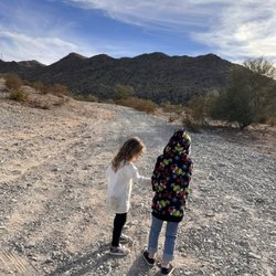
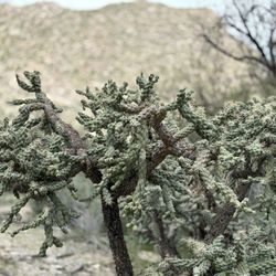
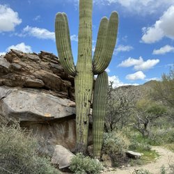
Nice park with plenty of picturesque cacti! We stopped by here after grabbing some food to stretch the legs and get the kids to burn off some energy in nature. The weather at 10 am was gorgeous. The park was filling up with day hikers. Tip: Military Discount will get you in for day use, but one person. In the vehicle will end up paying to get it in. There are several trails that can take you up to th peaks for near 360-degree views of the area. The park is surrounded by the iconic saguaro cactus. It's cool to see how big they can get. There are hikea for kids and adults of all ages with various grad s of difficulty, but nothing so difficult. Not much scrambling is needed to be done, and you should stay on the trails. Not that the hikes will keep you out for very long, but you should always bring water. When you leave your vehicle for the trails. Also, bring out what you bring in. There are currently new bathroom facilities under construction near the trailheads. The park also has several picnic areas and a small swing set for picnic side entertainment. The state rangers at the visitor center are very nice I would stop at this park again. It is easily accessible from IH10 and a very cool attraction north of Tucson. I bet the sunsets here rock! The gates close at 10pm for those evening/night hikers, and those staying overnight

This is a beautiful but very challenging hike. It's a little less than 3 miles but very steep. There are cables to assist you in the hardest spots of the trail. Make sure to bring plenty of water and grippy gloves. They do sell gloves at their shop in case you forget them. Their shop is very nice and has cold drinks and souvenirs at very reasonable prices. $7 dlls for the entrance to the park.

If you're in decent shape, plan on 2-1/2 to 3 hours for a 3.2 mile round trip to the top and back down. Hunter Trail is the most popular to reach the summit. There are numerous steel-cable assisted "climbs" ranging from 10 feet long to over 50 feet. Those cables are there because the slope is extremely steep or the width to the trail's edge is very narrow. The cables are very smooth but sweat and sun can render them hard to grip, so BRING leather gloves. The linear distance is not long but the vertical ascent is 1,400 feet but only 1.6 miles long which is why the hike is so steep. On this April weekend morning there were roughly 20-25 people that we passed, either going up/down, so a little busy Most folks conquer Hunter Trail in the morning. At that time at least 2/3 of your hike will be in the sun (Hunters Trail mostly faces due North) especially come summer when the earth's axis pins the sun straight up. TWO water bottles should be enough if you're not reckless about temps. And an apple/granola bar as quick carbs should suffice at the top. It's a hard climb to the top but the downhill - being just as steep - can be quite slippery with all of the shifting pebbles and sand-covered rocks. So wearing gloves on the entire descent proved prudent for us. Note: there are four single-file cable passes in the upper half of the hike. You might have to wait up to 5 minutes for any group to finish passing through those sections before you can progress in the opposite direction. $7 vehicle entrance fee is reasonable and just $3 for a bicycle or pedestrian if not entering by car. Visitor center/gift shop on the drive out is worth a quick stop. Prices are quite reasonable there too for books, hats, t-shirts.

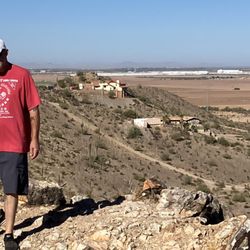
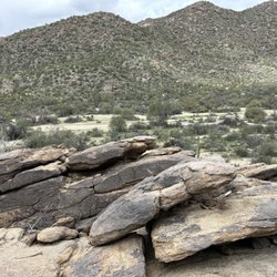
Originally visited park to take a look at Peak that I was climbing. The State Park is the Location of the most Northern battle of Civil War. There is information about this historical event. The park has RV sites and camping close to hiking trails. There are a variety of hikes of different skill levels. All the hikes are exposed, with very little shade and can be warm even in March. Best to start early on all of them. The peak is a stunning landmark to photograph especially at sunrise or sunset. As I stated my reason for the visit was to hike the Hunter Trail to the summit. Rated Difficult, it's not for those afraid of heights and inexperienced hiker. The trail is a little more than 3 miles with elevation gain of more than 2,000 feet. There are number of cables to aide in the steeper areas, bring gloves. Some of the sections are very narrow with only cables for security. There is a climb that is 90 degrees with double cables for support as you scramble up. There are some high step-ups in areas. This is an out and back trail so what you go up, you go back down. As you wind your way up the peak you make it to the summit which provides expansive view of the desert below. The front side of peak, hike cables are pretty easy, once you reach the Saddle area is when it becomes more technical. It can look frightening, however it doesn't take a lot of upper body strength if you properly use your legs on the step ups. We are somewhat experienced hikers although in our 60s. Start at sunrise, fewer hikers and cooler. Bring plenty of water. We left one bottle at the Saddle for the way back to lighten load. Bring gloves for handling cables, wear good tread hiking boots, hat and sunscreen. Check park website for other trails. There is another trail that comes in from the backside, we chose not to add extra miles through desert to hike. It's one of those hikes you have a feeling of a challenge completed. Enjoy!

Inside the park is so different from what we see from the 10 freeway. The mountains surrounding the park looked amazing. There are 3 loops of campsites to choose from. The rangers are actively doing their rounds day in and day out. You'll feel safe here. Although it's not a full hook up, there are restrooms near the campsites. This is a good place for mountain climbing, hiking and star gazing. We really enjoyed our stay here. The only issue here was the bees at the dump station! I wish they have more than one. You have to be really careful because there were a swarm of bees when it was our time to dump!! But all in all, it was an okay experience.

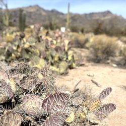
Came here March 12 when the wildflowers were blooming, and it was absolutely beautiful. Many trails present, including easy and moderate trails (Nature Trail, Calloway Trail, Sunset Vista Trail). I enjoyed the informational plaques along the Nature Trail. I also did Hunter Trail to Picacho Peak, which was challenging and technical at times, but very fun and rewarding! There are portions of cables on the east side, but it's after you reach the saddle and start descending the west side when the cables are more present and really helpful. Check out AllTrails for more detailed trail info. During wildflower season, expect a wait to enter the park @ the pay station. I arrived at the highway exit (Exit 219) around 11:30am on a Sunday, and the car line was about .7 miles from the entrance. It's slow, but inches along. I did see people park along the road and even at the gas stations, and walk into the park. Even when I left around 4pm, there was a short line to get in. Park closes at sunset, so plan accordingly.

Picacho Peak is a staple along the highway near Tucson. And the hike to the summit is tough and interesting! You know the cliche about walking to school uphill both ways? That's the hike to the summit. You go up desert paths, down rocks, up rocks, up more paths - there are chains and makeshift bridges, some climbing involved - this is a full body endeavor. Beautiful views though! And everyone we met along the way was very nice. If you plan to hike, I recommend visiting in the cooler months!

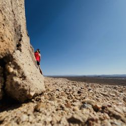
Climbing the distinctive Picacho Peak was on my list of things to do in the area, so here I am. It's a state park, requiring state fees. $7 per carload. Note that there are two separate parking areas near the trailhead. I parked along the road with so many other folks. Started later in the day than I'd like, but it was still sort of cool temps. Not that it mattered much because I started sweating pretty soon after I started. The path to the saddle was pretty much straight up. The views on both sides of the saddle were impressive. Then the cables came into play as the trail went down then up along the rock face. Lots of fun scrambling up and down but remember to go at your own pace. Sometimes the cables are more of a hindrance, but I understood why they are there. Once at the top there were a lot of places to sit and enjoy the 360 views. On the way down the cables actually came in handy. It was a perfect day for the climb and lots of other folks felt the same. Would highly recommend!
")
3.5 stars Nice state park. There are trails to go hiking, the Nature Hike is moderate and is a short loop. The other trails are more challenging. You can search on YouTube for "picacho peak cables" and you will see how steep some of the challenging trails are. It is best to catch the wildflowers when in bloom. The Visitors Center is pretty small. Not much to it. Very small gift shop. Bathrooms. Drink vending machine. Camp grounds are modest. This being Saguaro country, there are no campground spaces with trees. The picnic tables are covered with a small roof, but that doesn't help much when the sun is not at the right spot in the sky, which is probably most of the time. All spaces are electric now, so bring your RV. Campground just seems kind of plain. There are group areas which you can reserve. Plenty of picnic areas. $7 a car for a day pass. 5* = A top favorite. Mind-blowing good. I will definitely return and I will go out of my way to go here. Worth every dime of my money. 4* = Outstanding. Tucson-top-tier. Some elements not quite as good as it gets, but it still is worthy of my regular business. 3* = Good experience. I might do repeat business if it is convenient, the only option, the only one in its category, or on a whim, but would not be among the first thing to come to mind. Would definitely recommend you trying it to get your own take on it. 2* = Not so good. Would not recommend at all. Waste of money. 1* = How are they still in business? Stay away at all costs!


2 months ago


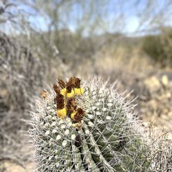
I've been a long time hiker and just absolutely love it! This is an AZ state park that I haven't visited until today! I saw a guided hike for the Sunset Vista Trail and signed up for it. This trail will take you up to the Picacho Peak, which is pretty cool! There hasn't been a peak that I've hiked to in my life that wasn't awesome! Do know that this hike is not recommended for beginners. $10 fee for day use and the visitor center out front has lots of items for purchase like books, T shirts, postcards, etc. Bathrooms also available. Sunset trailhead is the last stop on the map the ranger gives you. Ample parking and bathrooms available. We met our hike leader Charles at 10am and started on this hike. And while this hike isnt that long, about 3 miles one way, do know that the last mile of the hike is a lot of climbing up with many railings to help you up. If you're afraid of heights or not comfortable with climbing, I don't recommend this hike. Bring gloves, super helpful! Also, once you get to the top, it is more windy and cold (bring a jacket)! We took a lot longer hiking as a group vs me doing this solo but that was ok. I learned a lot about the history of this park and that there was a Civil War battle out here and all the different kinds of plants out here. Overall, a lovely day to be outdoors and I really enjoyed this hike, it was like a mini baby Angel's Landing in Zion! Definitely come and hike a few of their trails, its so pretty with all the saguaros and chollas! I loved it! read more


Nice park with plenty of picturesque cacti! We stopped by here after grabbing some food to stretch the legs and get the kids to burn off some energy in nature. The weather at 10 am was gorgeous. The park was filling up with day hikers. Tip: Military Discount will get you in for day use, but one person. In the vehicle will end up paying to get it in. There are several trails that can take you up to th peaks for near 360-degree views of the area. The park is surrounded by the iconic saguaro cactus. It's cool to see how big they can get. There are hikea for kids and adults of all ages with various grad s of difficulty, but nothing so difficult. Not much scrambling is needed to be done, and you should stay on the trails. Not that the hikes will keep you out for very long, but you should always bring water. When you leave your vehicle for the trails. Also, bring out what you bring in. There are currently new bathroom facilities under construction near the trailheads. The park also has several picnic areas and a small swing set for picnic side entertainment. The state rangers at the visitor center are very nice I would stop at this park again. It is easily accessible from IH10 and a very cool attraction north of Tucson. I bet the sunsets here rock! The gates close at 10pm for those evening/night hikers, and those staying overnight read more

This is a beautiful but very challenging hike. It's a little less than 3 miles but very steep. There are cables to assist you in the hardest spots of the trail. Make sure to bring plenty of water and grippy gloves. They do sell gloves at their shop in case you forget them. Their shop is very nice and has cold drinks and souvenirs at very reasonable prices. $7 dlls for the entrance to the park. read more


If you're in decent shape, plan on 2-1/2 to 3 hours for a 3.2 mile round trip to the top and back down. Hunter Trail is the most popular to reach the summit. There are numerous steel-cable assisted "climbs" ranging from 10 feet long to over 50 feet. Those cables are there because the slope is extremely steep or the width to the trail's edge is very narrow. The cables are very smooth but sweat and sun can render them hard to grip, so BRING leather gloves. The linear distance is not long but the vertical ascent is 1,400 feet but only 1.6 miles long which is why the hike is so steep. On this April weekend morning there were roughly 20-25 people that we passed, either going up/down, so a little busy Most folks conquer Hunter Trail in the morning. At that time at least 2/3 of your hike will be in the sun (Hunters Trail mostly faces due North) especially come summer when the earth's axis pins the sun straight up. TWO water bottles should be enough if you're not reckless about temps. And an apple/granola bar as quick carbs should suffice at the top. It's a hard climb to the top but the downhill - being just as steep - can be quite slippery with all of the shifting pebbles and sand-covered rocks. So wearing gloves on the entire descent proved prudent for us. Note: there are four single-file cable passes in the upper half of the hike. You might have to wait up to 5 minutes for any group to finish passing through those sections before you can progress in the opposite direction. $7 vehicle entrance fee is reasonable and just $3 for a bicycle or pedestrian if not entering by car. Visitor center/gift shop on the drive out is worth a quick stop. Prices are quite reasonable there too for books, hats, t-shirts. read more

 4/2024 - Hiking Near Me")
 - Hiking Near Me")
Originally visited park to take a look at Peak that I was climbing. The State Park is the Location of the most Northern battle of Civil War. There is information about this historical event. The park has RV sites and camping close to hiking trails. There are a variety of hikes of different skill levels. All the hikes are exposed, with very little shade and can be warm even in March. Best to start early on all of them. The peak is a stunning landmark to photograph especially at sunrise or sunset. As I stated my reason for the visit was to hike the Hunter Trail to the summit. Rated Difficult, it's not for those afraid of heights and inexperienced hiker. The trail is a little more than 3 miles with elevation gain of more than 2,000 feet. There are number of cables to aide in the steeper areas, bring gloves. Some of the sections are very narrow with only cables for security. There is a climb that is 90 degrees with double cables for support as you scramble up. There are some high step-ups in areas. This is an out and back trail so what you go up, you go back down. As you wind your way up the peak you make it to the summit which provides expansive view of the desert below. The front side of peak, hike cables are pretty easy, once you reach the Saddle area is when it becomes more technical. It can look frightening, however it doesn't take a lot of upper body strength if you properly use your legs on the step ups. We are somewhat experienced hikers although in our 60s. Start at sunrise, fewer hikers and cooler. Bring plenty of water. We left one bottle at the Saddle for the way back to lighten load. Bring gloves for handling cables, wear good tread hiking boots, hat and sunscreen. Check park website for other trails. There is another trail that comes in from the backside, we chose not to add extra miles through desert to hike. It's one of those hikes you have a feeling of a challenge completed. Enjoy! read more


Inside the park is so different from what we see from the 10 freeway. The mountains surrounding the park looked amazing. There are 3 loops of campsites to choose from. The rangers are actively doing their rounds day in and day out. You'll feel safe here. Although it's not a full hook up, there are restrooms near the campsites. This is a good place for mountain climbing, hiking and star gazing. We really enjoyed our stay here. The only issue here was the bees at the dump station! I wish they have more than one. You have to be really careful because there were a swarm of bees when it was our time to dump!! But all in all, it was an okay experience. read more


Came here March 12 when the wildflowers were blooming, and it was absolutely beautiful. Many trails present, including easy and moderate trails (Nature Trail, Calloway Trail, Sunset Vista Trail). I enjoyed the informational plaques along the Nature Trail. I also did Hunter Trail to Picacho Peak, which was challenging and technical at times, but very fun and rewarding! There are portions of cables on the east side, but it's after you reach the saddle and start descending the west side when the cables are more present and really helpful. Check out AllTrails for more detailed trail info. During wildflower season, expect a wait to enter the park @ the pay station. I arrived at the highway exit (Exit 219) around 11:30am on a Sunday, and the car line was about .7 miles from the entrance. It's slow, but inches along. I did see people park along the road and even at the gas stations, and walk into the park. Even when I left around 4pm, there was a short line to get in. Park closes at sunset, so plan accordingly. read more


 - Hiking Near Me")

6 months ago
Picacho Peak is a staple along the highway near Tucson. And the hike to the summit is tough and interesting! You know the cliche about walking to school uphill both ways? That's the hike to the summit. You go up desert paths, down rocks, up rocks, up more paths - there are chains and makeshift bridges, some climbing involved - this is a full body endeavor. Beautiful views though! And everyone we met along the way was very nice. If you plan to hike, I recommend visiting in the cooler months! read more


2 years ago
Climbing the distinctive Picacho Peak was on my list of things to do in the area, so here I am. It's a state park, requiring state fees. $7 per carload. Note that there are two separate parking areas near the trailhead. I parked along the road with so many other folks. Started later in the day than I'd like, but it was still sort of cool temps. Not that it mattered much because I started sweating pretty soon after I started. The path to the saddle was pretty much straight up. The views on both sides of the saddle were impressive. Then the cables came into play as the trail went down then up along the rock face. Lots of fun scrambling up and down but remember to go at your own pace. Sometimes the cables are more of a hindrance, but I understood why they are there. Once at the top there were a lot of places to sit and enjoy the 360 views. On the way down the cables actually came in handy. It was a perfect day for the climb and lots of other folks felt the same. Would highly recommend! read more


3.5 stars Nice state park. There are trails to go hiking, the Nature Hike is moderate and is a short loop. The other trails are more challenging. You can search on YouTube for "picacho peak cables" and you will see how steep some of the challenging trails are. It is best to catch the wildflowers when in bloom. The Visitors Center is pretty small. Not much to it. Very small gift shop. Bathrooms. Drink vending machine. Camp grounds are modest. This being Saguaro country, there are no campground spaces with trees. The picnic tables are covered with a small roof, but that doesn't help much when the sun is not at the right spot in the sky, which is probably most of the time. All spaces are electric now, so bring your RV. Campground just seems kind of plain. There are group areas which you can reserve. Plenty of picnic areas. $7 a car for a day pass. 5* = A top favorite. Mind-blowing good. I will definitely return and I will go out of my way to go here. Worth every dime of my money. 4* = Outstanding. Tucson-top-tier. Some elements not quite as good as it gets, but it still is worthy of my regular business. 3* = Good experience. I might do repeat business if it is convenient, the only option, the only one in its category, or on a whim, but would not be among the first thing to come to mind. Would definitely recommend you trying it to get your own take on it. 2* = Not so good. Would not recommend at all. Waste of money. 1* = How are they still in business? Stay away at all costs! read more
 - Hiking Near Me")


5 years ago
Been hiking quite a bit in my time But this was my first climb with cable Truly need to bring water They have folks hiking to be sure everyone has enough read more


3 years ago
3 years ago
3 years ago
6 years ago
Picacho Peak Plaza is located directly across Picacho Peak State Park, AZ & I-10... Nice location!! read more

4 years ago
5 years ago
More info about Picacho Peak State Park
Picacho, AZ 85141
Directions
(520) 466-3183
Call Now
Visit Website
https://azstateparks.com/picacho/things-to-do/trails
Hours
Outdoor Amenities
Other Amenities
Ask the Community - Picacho Peak State Park
Review Highlights - Picacho Peak State Park
You might also consider


Picacho Peak State Park - hiking - Updated July 2026
Best of Picacho
People found Picacho Peak State Park by searching for…
Things to Do in Picacho, Arizona
Star Gazing in Picacho, Arizona
Easy Hiking Trails in Picacho, Arizona
Rock Climbing in Picacho, Arizona
Parks With Pull Up Bars in Picacho, Arizona
National Parks in Picacho, Arizona
Scenic Drive in Picacho, Arizona
Places to Take Pictures in Picacho, Arizona
River Swimming in Picacho, Arizona
Watch Sunset in Picacho, Arizona
Playgrounds in Picacho, Arizona
Hiking Trails With Waterfalls in Picacho, Arizona
Long Term Rv Parking in Picacho, Arizona
Rv Dump Station in Picacho, Arizona
Public Shower in Picacho, Arizona
Sunset View in Picacho, Arizona
Basketball Courts in Picacho, Arizona
Picnic Spots in Picacho, Arizona
Picnic Areas in Picacho, Arizona
Skyline View in Picacho, Arizona
Beach Camping in Picacho, Arizona
Trending Searches in Picacho, AZ
Browse Articles
Browse Nearby
Browse Brands
Related Cost Guides
Related Searches in Picacho, AZ
Affordable Long Term RV Parking in Picacho, Arizona
Affordable RV Rental Options in Picacho, Arizona
Best Nature Trails for Hiking in Picacho, Arizona
Best Parks for Parties and Events in Picacho, Arizona
Best Places for Horseback Riding in Picacho, Arizona
Best RV Dump Stations Available in Picacho, Arizona
Best Spots for Star Gazing in Picacho, Arizona
Best Water Parks for Kids in Picacho, Arizona
Browse Vacation Rentals to Book in Picacho, Arizona
Check Out Great Playgrounds in Picacho, Arizona
Discover Baseball Fields Around Picacho, Arizona
Discover Dog Friendly Trails to Explore in Picacho, Arizona
Discover Free Campgrounds in Picacho, Arizona Area
Discover Scenic Beach Camping Sites in Picacho, Arizona
Discover Top Nature Parks to Visit in Picacho, Arizona
Discover a Hiking Trail in Picacho, Arizona
Discover the Best Night Hike Trails in Picacho, Arizona
Dog-Friendly Hikes With Dogs in Picacho, Arizona
Enjoy Camping Adventures Around Picacho, Arizona
Enjoy Hiking Adventures in Picacho, Arizona
Enjoy Tent Camping Spots Around Picacho, Arizona
Enjoy the Best Family Activities in Picacho, Arizona
Enjoy the Best Picnic Spots and Ideas in Picacho, Arizona
Enjoy the Best Walking Trails in Picacho, Arizona
Exciting Cliff Jumping Spots in Picacho, Arizona
Experience Stunning Sunset Views in Picacho, Arizona
Explore Beautiful Parks and Green Spaces in Picacho, Arizona
Explore Easy Hikes Perfect for All in Picacho, Arizona
Explore Free Picnic Areas Around Picacho, Arizona
Explore Hotels & Travel Options in Picacho, Arizona
Explore Jet Skis for Sale or Rent in Picacho, Arizona
Explore Landmarks & Historical Buildings in Picacho, Arizona
Explore Mobile Home Parks in Picacho, Arizona Now
Explore Parks With Pull Up Bars in Picacho, Arizona
Explore Popular Campgrounds Near Picacho, Arizona
Explore Popular RV Parks Around Picacho, Arizona
Explore Popular Scenic Views Near Picacho, Arizona
Explore Popular View Points Around Picacho, Arizona
Explore Scenic Lakes to Visit in Picacho, Arizona
Explore Summer Camps for All Ages in Picacho, Arizona
Explore Top Dog Parks in Picacho, Arizona Near You
Explore Top Water Parks in Picacho, Arizona Today
Explore Volleyball Courts Available in Picacho, Arizona
Explore the Best Boating Spots in Picacho, Arizona
Explore the Best Swimming Holes Around Picacho, Arizona
Family Friendly Hiking With Kids in Picacho, Arizona
Find Batting Cages Near You in Picacho, Arizona
Find Cozy Camping Cabins in Picacho, Arizona
People who viewed Picacho Peak State Park also viewed
Picacho Peak State Park
87 reviews
Honeybee Canyon Loop Trail
15 reviews
Tortolita Mountain Park
2 reviews
Vistoso Trails Nature Preserve
2 reviews
Wishing Well Trailer Court
6 reviews
Gladden Farms Park and Splash Pad
14 reviews
Northwest Community Park
2 reviews
Naranja Park || Oro valley
19 reviews
Rancho De Los Cerros
4 reviews
Foolish Pleasure Hot Air Balloon Rides
32 reviews