Wild Burro Trailhead Photos


More like Wild Burro Trailhead
Recommended Reviews - Wild Burro Trailhead
Start your review...

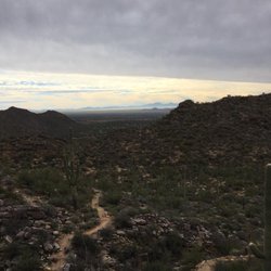
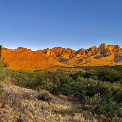
I came here on a Saturday morning around 10AM, and the parking lot still has plenty of space although there were people out and about. The trail itself wasn't the most interesting as the views were all the same, so the hike seemed pretty long. According to the maps at the trailhead, this hike is 8.5 miles, not 8. The Burro trail coming back is mostly flat. Took about 3.5 hours to do the hike, and saw quite a few people on the trail too. read more

4 years ago
14 years ago
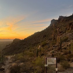
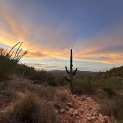
I don't really recommend Wild Burrow Trail as a hike unless you are looking for something non-strenuous and happen to be in the area. Wild Burrow Trail is located by Dove Mountain which is part of the Tortolita Moutains. It's located about 30 minutes outside of Tucson. The path is graded dirt for the first half, and then gets slightly more rugged as climb the nearby mountain. There are a number of trails that kind of join onto this one so you can mix and match as you do. I went in September, but I'm told that in April and May the cactus wildflowers would be in bloom - which may be better time to go. What is nice is that it's located by the Ritz Carlton so when you're done hiking, you can drop in for a drink and relax a bit before driving home. Level: Easy read more


7 years ago
More info about Wild Burro Trailhead
14810 N Secret Springs Dr
Marana, AZ 85658
Directions
Hours
Outdoor Amenities


Wild Burro Trailhead - hiking - Updated July 2026
Best of Marana
People found Wild Burro Trailhead by searching for…
Trending Searches in Marana, AZ
Cliff Jumping near Wild Burro Trailhead
Day Trips near Wild Burro Trailhead
Dog Friendly Beaches near Wild Burro Trailhead
Dog Friendly Trails near Wild Burro Trailhead
Fruit Picking near Wild Burro Trailhead
Kayak Rental near Wild Burro Trailhead
Lakes & Ponds near Wild Burro Trailhead
Lavender Farm near Wild Burro Trailhead
Off Road Trails near Wild Burro Trailhead
Outdoor Activities near Wild Burro Trailhead
Parks For Picnics near Wild Burro Trailhead
Picnic Spots near Wild Burro Trailhead
Places To Swim near Wild Burro Trailhead
Pokemon Go near Wild Burro Trailhead
Pool Day Pass near Wild Burro Trailhead
Public Shower near Wild Burro Trailhead
Public Swimming Pools near Wild Burro Trailhead
River Swimming near Wild Burro Trailhead
Rock Quarry near Wild Burro Trailhead
Scenic Night View near Wild Burro Trailhead
Scenic Overlook near Wild Burro Trailhead
Secluded Spots near Wild Burro Trailhead
Soccer Store near Wild Burro Trailhead
Sunrise View near Wild Burro Trailhead
Swimming Holes near Wild Burro Trailhead
Swimming Lakes near Wild Burro Trailhead
Browse Articles
Browse Nearby
BEST of Marana, Arizona Coffee near Wild Burro Trailhead
BEST of Marana, Arizona Restaurants near Wild Burro Trailhead
BEST of Marana, Arizona Breakfast near Wild Burro Trailhead
BEST of Marana, Arizona Things to Do near Wild Burro Trailhead
BEST of Marana, Arizona Shopping near Wild Burro Trailhead
BEST of Marana, Arizona Horseback Riding near Wild Burro Trailhead
Browse Brands
Related Searches in Marana, AZ
Best Dog Hiking Trails Around Marana, Arizona
Best Fishing Locations and Guides in Marana, Arizona
Best Places for Horseback Riding in Marana, Arizona
Best Sightseeing Experiences Available in Marana, Arizona
Check Out Off Road Trails in Marana, Arizona
Discover Dog Friendly Trails to Explore in Marana, Arizona
Discover Easy Hiking Trails Near Marana, Arizona
Discover Scenic Mountain Bike Trails Near Marana, Arizona
Discover a Hiking Trail in Marana, Arizona
Discover the Best Night Hike Trails in Marana, Arizona
Dog-Friendly Hikes With Dogs in Marana, Arizona
Enjoy Camping Adventures Around Marana, Arizona
Enjoy Kayaking Adventures in Marana, Arizona
Enjoy Off Leash Dog Hikes in Marana, Arizona
Enjoy Tent Camping Spots Around Marana, Arizona
Enjoy a Beautiful Waterfall Hike in Marana, Arizona
Enjoy the Best Walking Path in Marana, Arizona
Enjoy the Best Walking Trails in Marana, Arizona
Experience Stunning Sunset Views in Marana, Arizona
Explore Beautiful Parks and Green Spaces in Marana, Arizona
Explore Easy Hikes Perfect for All in Marana, Arizona
Explore Fun Activities to Do in Marana, Arizona
Explore Popular Campgrounds Near Marana, Arizona
Explore Popular Scenic Drives Around Marana, Arizona
Explore Popular State Park Destinations in Marana, Arizona
Explore Top Dog Parks in Marana, Arizona Near You
Explore the Best Beach Spots in Marana, Arizona
Family Friendly Hiking With Kids in Marana, Arizona
Find Cozy Camping Cabins in Marana, Arizona
Find Popular Ziplining Spots Around Marana, Arizona
Find Top-Rated Waterfalls in Marana, Arizona Now
Find the Best Parks for Picnics in Marana, Arizona
Find the Best Playgrounds to Visit in Marana, Arizona
Hiking Trails With Waterfalls in Marana, Arizona
Off Leash Dog Hiking Trails in Marana, Arizona
Plan a Scenic Drive Route Near Marana, Arizona
Popular Outdoor Activities to Try in Marana, Arizona
Popular Picnic Spots to Visit in Marana, Arizona
Popular Things to See in Marana, Arizona
Safe River Swimming Areas in Marana, Arizona
Safe and Fun Parks for Kids in Marana, Arizona
Top Hiking Trails to Explore in Marana, Arizona
Top Playgrounds for Kids to Enjoy in Marana, Arizona
Top Running Trails to Explore in Marana, Arizona
Top Swimming Lakes to Enjoy in Marana, Arizona
Top Swimming Spots and Pools in Marana, Arizona
Top-Rated Camping Sites in Marana, Arizona