Honeybee Canyon Loop Trail Photos


You might also consider
More like Honeybee Canyon Loop Trail
Recommended Reviews - Honeybee Canyon Loop Trail
Start your review...

Reviews With Photos

This is a very small or rather short trail, nestled in the middle of neighborhoods in the Rancho Vistoso area. I was surprised to see the dam area. It felt like I was in a different place, you were surrounded by big rocks and beautiful wild flowers and lots of saguaros around the area. I think, spring is the best time to visit this trail, the vegetation is lush, lots of wild birds. Since wildlife is actively searching for food, better keep your eyes open for any kind of animals. But we didn't see anything out of the ordinary. Just birds and rabbits. I would definitely come back to this trail.


I love walking/hiking this area it is so close and convenient to me. It is very clean and easy to walk some spots I wander off the trail and make my own way because I am familiar with area. So much beauty and nature out here to see and enlighten all the senses. If you want to go for an easy walk/hike this is definitely beginner friendly. There are picnic areas with shade and bathrooms with running water available. Go take the family or go alone.. Enjoy God's creation so much natural beauty here!

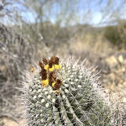
Great Sonoran Desert Mountain Biking on the trail loops! Yes, weaving a way on open cattle range, hard pack decomposed granite & sand single track trails lined with chain fruit Cholla, Prickly Pear, Jumping Cholla, Yucca and other flora and fauna - ya gonna have rippin fun in the sun! With lots of cacti spines hanging over the trail ready to trick you when you are blazin and leanin into that curve, as the fat tires grip - those cacti ready to stick you, prick you and catch a ride on you booty, arm or leg. Into the Honey Bee Canyon cacti cosmos everything has spines to snag ya booty and dig deep in ya booty soft skin. Open Trailforks or AllTrails apps and see the east and west legs loop for a 18 mile ride approx. OK to park your vehicle on E Miravista Lane in the Methodist Church dirt lot right next to North Oracle Road. Or park at Golder Ranch Road, Basha's. I have done both! I like to ride out on the west leg trail from the church lot out 9 miles. Next add a ride into the Badlands loops 6-8 miles or so, and connect up again with the west leg back for a 25 mile round trip blast. Badlands! Badlands! Call it Funlands! Mountain-Bikerlands! The terrain is more rocky. Trail more curvaceous! Cacti spines tenacious! Trick, stick & prick a rider! Watch out for the prickly Pear ears and cholla spiny spurs in the trail - I think the cattle knock them down there for fun so the bikers run over 'em. Go tubeless! Spines not taking the air out of your tires or the fun out of your ride. Intermediate skills ok. Going fast you need maneuvering skills to steer clear of cacti. Love this Baaadassss trail system!

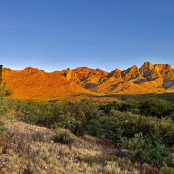
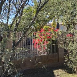
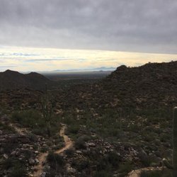
The south loop offers broad views of Pusch Ridge, Samaniego Peak and Mt. Lemmon. Walk down the concrete ramp at the west the end of the parking lot and follow the signs for the 1.1-mile loop on the south side of Rancho Vistoso Boulevard. The trail crosses over sandy Honey Bee Canyon Wash before meandering through a saguaro and cholla forest. Afterward, there is a rocky trail before you loop back down into the wash shaded by canyon walls. Finally, the trail passes through an old rock dam on the way back to the parking lot. But, this small park offers more! If you go north from the bottom of the concrete ramp, you'll be treated to ample wildlife, beautiful canyon walls that include petroglyphs, and a lovely 'framed' view of Pusch Ridge on your walk back.

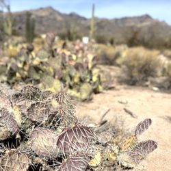
This park is the perfect place to do some light hiking in the Oro Valley area. The trails are well marked and maintained, there are clean facilities, plenty of benches, and a few ramadas available for picnics. You can see most of the common types of Arizona cacti on this loop, which is only about 1.5 miles or so. In terms of wildlife, I've only ever seen different types of birds, lizards, and insects, but I know others have spotted javelina here in the past. If you're not someone who hikes a lot, this will probably feel like a moderate challenge, but for the experienced hiker, it will be a breeze. Walking through the actual Honeybee Dam is gorgeous too, so check it out! FYI though, the full length of the trail is not wheelchair accessible.

Nice high end area surrounded by homes. Hiking trails are hard to follow sometimes as other people mark their own trails. I made my way towards the stone wall with the door. Once you go through you can follow the washes so you don't get lost. I got lost as i made my way around the tiny peak. There's a barbed wired fence that was torn in places. I enjoyed hiking the washes, and my gps worked so i could see where I was. A lot of kids with mom and grandma walking around. Not so peaceful but you can go off the beaten path which makes it interesting. Bathroom was decent but its a one seaters.

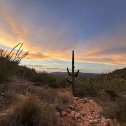
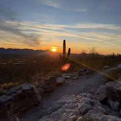
Buzzzz! If you are a buzz-zz-y body, then Honey Bee Canyon has a sweet adventure for you! Perfectly located in the hive of Oro Valley, Honey Bee Canyon features scenic views of Saguaro Cactus and Mt. Lemmon. The majority of the trail is in a creek-bed that crisscrosses through rocks, boulders, and Saguaro Cactus (sometimes you feel like you're trekking on sand at the beach). If you are looking for a shorter hike in the Tuscon and Oro Valley area, this Arizona hike is for you! Honey Bee Canyon Park was completed in 2012 after a public works expansion in the Oro Valley Area. The park features a complimentary parking area and picnic tables for outdoor relaxation. Although the developed park area is fairly small, the scenic dirt trail of Honey Bee Canyon runs for a few miles in the creek bed.


Honeybee Canyon Loop Trail. Oro Valley, AZ. Late Nov, 2025. We wanted to do an easy morning hike, and the Honeybee Canyon Park was close to our resort. This family-friendly park offers about three miles of hiking trails, and we decided to do the Honeybee Canyon Loop Trail. Being mostly flat, most of the trails are rated "easy", but there are a few short areas where the slope is a bit steep and you need to ascend/descend on slippery sand or gravel. Entrance to the park and parking are free; there are about 20 parking spaces. Per my AllTrails app, we walked about 1.6 miles on a route that included the rock dam, but turned back without completing the loop as it was starting to get hot, there was limited shade in the desert, and, most importantly, there's limited signage on the trail (or anywhere in the park for that matter) so we kept going off-trail. This would've been a 5-star review if the signage was better to keep us on trail. read more


4 months ago
Lovely trail and park. Open low bush shrubs for popular backyard birding. And a paved path to restrooms, but hard packed gravel the rest of the trails. read more


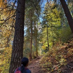
This is one of my absolute favorite hiking spots in the Tucson area! With two sides, one leads to some well preserved petroglyphs and the other to an old dam-like structure. The views are absolutely stunning and the hikes are fairly simple. Some do require some uphill hiking but nothing too major! Highly recommend visiting in spring but be mindful of wildlife in the area! read more


This is a very small or rather short trail, nestled in the middle of neighborhoods in the Rancho Vistoso area. I was surprised to see the dam area. It felt like I was in a different place, you were surrounded by big rocks and beautiful wild flowers and lots of saguaros around the area. I think, spring is the best time to visit this trail, the vegetation is lush, lots of wild birds. Since wildlife is actively searching for food, better keep your eyes open for any kind of animals. But we didn't see anything out of the ordinary. Just birds and rabbits. I would definitely come back to this trail. read more


5 years ago
Great trails in a beautiful area. We opted to keep it fairly short as we went very late during the heat. Because of the monsoons, there were millions of butterflies almost like rain. It was nuts! A great place to go for a low impact walk/hike. read more


5 years ago
I love walking/hiking this area it is so close and convenient to me. It is very clean and easy to walk some spots I wander off the trail and make my own way because I am familiar with area. So much beauty and nature out here to see and enlighten all the senses. If you want to go for an easy walk/hike this is definitely beginner friendly. There are picnic areas with shade and bathrooms with running water available. Go take the family or go alone.. Enjoy God's creation so much natural beauty here! read more


Great Sonoran Desert Mountain Biking on the trail loops! Yes, weaving a way on open cattle range, hard pack decomposed granite & sand single track trails lined with chain fruit Cholla, Prickly Pear, Jumping Cholla, Yucca and other flora and fauna - ya gonna have rippin fun in the sun! With lots of cacti spines hanging over the trail ready to trick you when you are blazin and leanin into that curve, as the fat tires grip - those cacti ready to stick you, prick you and catch a ride on you booty, arm or leg. Into the Honey Bee Canyon cacti cosmos everything has spines to snag ya booty and dig deep in ya booty soft skin. Open Trailforks or AllTrails apps and see the east and west legs loop for a 18 mile ride approx. OK to park your vehicle on E Miravista Lane in the Methodist Church dirt lot right next to North Oracle Road. Or park at Golder Ranch Road, Basha's. I have done both! I like to ride out on the west leg trail from the church lot out 9 miles. Next add a ride into the Badlands loops 6-8 miles or so, and connect up again with the west leg back for a 25 mile round trip blast. Badlands! Badlands! Call it Funlands! Mountain-Bikerlands! The terrain is more rocky. Trail more curvaceous! Cacti spines tenacious! Trick, stick & prick a rider! Watch out for the prickly Pear ears and cholla spiny spurs in the trail - I think the cattle knock them down there for fun so the bikers run over 'em. Go tubeless! Spines not taking the air out of your tires or the fun out of your ride. Intermediate skills ok. Going fast you need maneuvering skills to steer clear of cacti. Love this Baaadassss trail system! read more


7 years ago
The south loop offers broad views of Pusch Ridge, Samaniego Peak and Mt. Lemmon. Walk down the concrete ramp at the west the end of the parking lot and follow the signs for the 1.1-mile loop on the south side of Rancho Vistoso Boulevard. The trail crosses over sandy Honey Bee Canyon Wash before meandering through a saguaro and cholla forest. Afterward, there is a rocky trail before you loop back down into the wash shaded by canyon walls. Finally, the trail passes through an old rock dam on the way back to the parking lot. But, this small park offers more! If you go north from the bottom of the concrete ramp, you'll be treated to ample wildlife, beautiful canyon walls that include petroglyphs, and a lovely 'framed' view of Pusch Ridge on your walk back. read more


This park is the perfect place to do some light hiking in the Oro Valley area. The trails are well marked and maintained, there are clean facilities, plenty of benches, and a few ramadas available for picnics. You can see most of the common types of Arizona cacti on this loop, which is only about 1.5 miles or so. In terms of wildlife, I've only ever seen different types of birds, lizards, and insects, but I know others have spotted javelina here in the past. If you're not someone who hikes a lot, this will probably feel like a moderate challenge, but for the experienced hiker, it will be a breeze. Walking through the actual Honeybee Dam is gorgeous too, so check it out! FYI though, the full length of the trail is not wheelchair accessible. read more


Nice high end area surrounded by homes. Hiking trails are hard to follow sometimes as other people mark their own trails. I made my way towards the stone wall with the door. Once you go through you can follow the washes so you don't get lost. I got lost as i made my way around the tiny peak. There's a barbed wired fence that was torn in places. I enjoyed hiking the washes, and my gps worked so i could see where I was. A lot of kids with mom and grandma walking around. Not so peaceful but you can go off the beaten path which makes it interesting. Bathroom was decent but its a one seaters. read more


9 years ago
Buzzzz! If you are a buzz-zz-y body, then Honey Bee Canyon has a sweet adventure for you! Perfectly located in the hive of Oro Valley, Honey Bee Canyon features scenic views of Saguaro Cactus and Mt. Lemmon. The majority of the trail is in a creek-bed that crisscrosses through rocks, boulders, and Saguaro Cactus (sometimes you feel like you're trekking on sand at the beach). If you are looking for a shorter hike in the Tuscon and Oro Valley area, this Arizona hike is for you! Honey Bee Canyon Park was completed in 2012 after a public works expansion in the Oro Valley Area. The park features a complimentary parking area and picnic tables for outdoor relaxation. Although the developed park area is fairly small, the scenic dirt trail of Honey Bee Canyon runs for a few miles in the creek bed. read more


8 years ago


9 years ago
Beautiful views! But be warned! The trail is not always well marked and there are many branches off of the trail that lead to dead ends. Your short hike can turn into a long one. Even if you get a little lost, the scenery is totally worth it. You'll make it back to the start eventually. read more


8 years ago
More info about Honeybee Canyon Loop Trail
13880 N Rancho Vistoso Blvd
Oro Valley, AZ 85755
Directions
Hours
Indoor Amenities
Outdoor Amenities
Ask the Community - Honeybee Canyon Loop Trail
Review Highlights - Honeybee Canyon Loop Trail


Honeybee Canyon Loop Trail - hiking - Updated July 2026
Best of Oro Valley
People found Honeybee Canyon Loop Trail by searching for…
Sunset View in Oro Valley, Arizona
Things to Do in Oro Valley, Arizona
Scenic View in Oro Valley, Arizona
Beaches in Oro Valley, Arizona
Picnic Areas in Oro Valley, Arizona
Dog Parks in Oro Valley, Arizona
Indoor Track in Oro Valley, Arizona
Walking Trails in Oro Valley, Arizona
Places to Take Pictures in Oro Valley, Arizona
Hiking Trails in Oro Valley, Arizona
Scenic Drive in Oro Valley, Arizona
Running Track in Oro Valley, Arizona
Easy Hikes in Oro Valley, Arizona
Watch Sunset in Oro Valley, Arizona
Off Road Trails in Oro Valley, Arizona
Dog Friendly Hiking Trails in Oro Valley, Arizona
Parks for Kids in Oro Valley, Arizona
Secret Spots in Oro Valley, Arizona
Playgrounds in Oro Valley, Arizona
Swimming Lakes in Oro Valley, Arizona
Scenic Overlook in Oro Valley, Arizona
Running Tracks Open to the Public in Oro Valley, Arizona
Trending Searches in Oro Valley, AZ
Black Owned Nail Salons in Oro Valley, AZ
Cliff Jumping in Oro Valley, AZ
Dog Friendly Beaches in Oro Valley, AZ
Dog Friendly Trails in Oro Valley, AZ
Fishing Spots in Oro Valley, AZ
Kayak Rental in Oro Valley, AZ
Kids Activities Outdoor in Oro Valley, AZ
Lakes & Ponds in Oro Valley, AZ
Lookout Points in Oro Valley, AZ
Mountain Biking in Oro Valley, AZ
Off Road Trails in Oro Valley, AZ
Outdoor Activities in Oro Valley, AZ
Outdoor Basketball Courts in Oro Valley, AZ
Picnic Spots in Oro Valley, AZ
Places To Swim in Oro Valley, AZ
Pool Day Pass in Oro Valley, AZ
Public Pools in Oro Valley, AZ
Public Shower in Oro Valley, AZ
River Swimming in Oro Valley, AZ
Running Trails in Oro Valley, AZ
Scenic Night View in Oro Valley, AZ
Scenic Overlook in Oro Valley, AZ
Secluded Spots in Oro Valley, AZ
Soccer Store in Oro Valley, AZ
Sunrise View in Oro Valley, AZ
Swimming Holes in Oro Valley, AZ
Swimming Lakes in Oro Valley, AZ
Things To Do With Kids in Oro Valley, AZ
Browse Nearby
BEST of Oro Valley, Arizona Coffee near Honeybee Canyon Loop Trail
BEST of Oro Valley, Arizona Restaurants near Honeybee Canyon Loop Trail
BEST of Oro Valley, Arizona Things to Do near Honeybee Canyon Loop Trail
BEST of Oro Valley, Arizona Parks near Honeybee Canyon Loop Trail
BEST of Oro Valley, Arizona Breakfast near Honeybee Canyon Loop Trail
BEST of Oro Valley, Arizona Lakes near Honeybee Canyon Loop Trail
Browse Brands
Related Searches in Oro Valley, AZ
Affordable Bike Repair Services in Oro Valley, Arizona
Affordable Bike Tune Up Services in Oro Valley, Arizona
Best Dirt Bike Riding Spots in Oro Valley, Arizona
Best Electric Bike Rental Services in Oro Valley, Arizona
Best Fishing Locations and Guides in Oro Valley, Arizona
Best Lookout Points to Visit in Oro Valley, Arizona
Best Off Leash Dog Parks in Oro Valley, Arizona
Best Parks for Parties and Events in Oro Valley, Arizona
Best Places for Horseback Riding in Oro Valley, Arizona
Best Spots for Star Gazing in Oro Valley, Arizona
Best Used Bikes for Sale Near Oro Valley, Arizona
Best Water Parks for Kids in Oro Valley, Arizona
Check Out Great Playgrounds in Oro Valley, Arizona
Check Out Off Road Trails in Oro Valley, Arizona
Discover Baseball Fields Around Oro Valley, Arizona
Discover Beautiful Garden Spots in Oro Valley, Arizona
Discover Fun Toddler Parks in Oro Valley, Arizona for Your Little One
Discover Lakes & Ponds to Explore in Oro Valley, Arizona
Discover Popular Bike Tours in Oro Valley, Arizona
Discover Popular Bike Trails in Oro Valley, Arizona
Discover Popular Photo Spots in Oro Valley, Arizona
Discover Scenic Mountain Bike Trails Near Oro Valley, Arizona
Discover Scenic Waterfall Spots in Oro Valley, Arizona
Discover Soccer Fields in Oro Valley, Arizona Near You
Discover Top State Parks to Visit in Oro Valley, Arizona
Discover a Hiking Trail in Oro Valley, Arizona
Discover the Best Beaches in Oro Valley, Arizona
Discover the Best Night Hike Trails in Oro Valley, Arizona
Dog-Friendly Hikes With Dogs in Oro Valley, Arizona
Enjoy Camping Adventures Around Oro Valley, Arizona
Enjoy Exciting Mountain Biking Adventures in Oro Valley, Arizona
Enjoy Hiking Adventures in Oro Valley, Arizona
Enjoy Kayaking Adventures in Oro Valley, Arizona
Enjoy Scenic Night View Experiences in Oro Valley, Arizona
Enjoy Tent Camping Spots Around Oro Valley, Arizona
Enjoy a Beautiful Waterfall Hike in Oro Valley, Arizona
Enjoy the Best Picnic Spots and Ideas in Oro Valley, Arizona
Enjoy the Best Tubing Experiences in Oro Valley, Arizona
Enjoy the Best Walking Path in Oro Valley, Arizona
Enjoy the Best Walking Trails in Oro Valley, Arizona
Explore BMX Bike Shops Near Oro Valley, Arizona
Explore Beautiful Botanical Gardens in Oro Valley, Arizona
Explore Beautiful Parks and Green Spaces in Oro Valley, Arizona
Explore Bike Rentals Throughout Oro Valley, Arizona
Explore Easy Hikes Perfect for All in Oro Valley, Arizona
Explore Electric Bikes Available in Oro Valley, Arizona
Explore Family-Friendly Zoos and Wildlife in Oro Valley, Arizona
Explore Free Picnic Areas Around Oro Valley, Arizona