
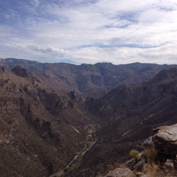
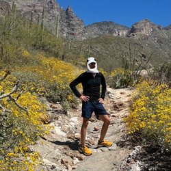
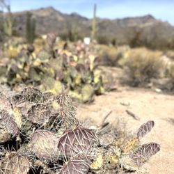
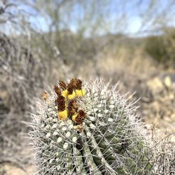
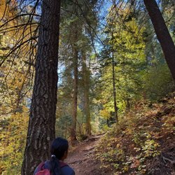
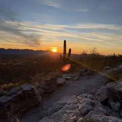
Blackett's Ridge Photos


You might also consider
More like Blackett's Ridge
Recommended Reviews - Blackett's Ridge
Start your review...

Reviews With Photos

I've done many hike. I've even done Haiku Stairs the legal way In Hawaii and that was easier than Blackett's Ridge! I'm not joking, I love to hike but I hated the day I did Blackett's Ridge. Be prepared for medium trafficked and false summits ever corner. I felt like I had reached the top an hour before I actually did. You know you're at the top when you see the sign that gives the stats of the mountain. Also, there are little squirrels up there that bite!! The view is great but you see the same view the entire time you are working your way up. I think doing this hike once was perfect.
1 year ago
I have been wanting to do this hike and finally got to do it today! It was low 50s when we started just before 7:00 am. Starting from the parking lot at Sabino Canyon we had plenty of sun until the Phoneline Trail split off into Blackett's Ridge. We then had some shade until we got further up the mountain. The trail is rocky with a lot of switchbacks. I would definitely recommend good hiking shoes! The trail is pretty hard since it is so steep, but it is rewarding. Getting to the top is an accomplishment the views are beautiful! If you are afraid of heights stop at the "end of trail sign" but if you are feeling good, taking a few more steps will give you an even greater appreciation of the "ridge" in Blackett's Ridge. Just be sure to take caution! I would definitely recommend this hike and I would 100% do it again! read more
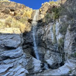
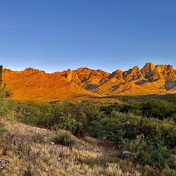
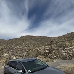
I had heard about Blackett's Ridge all the time while hiking in Sabino to Seven Falls, but never gave it much thought until checking it out a couple months ago. The initial stage is fairly level and shouldn't tire you out; however, once you've passed that part, it's a steady set of inclined switchbacks for what seems like a good while. Upon getting to the top, you begin to realize why it was worth the ascent--a fantastic view of the Tucson valley and the surrounding mountains! Be sure to bring plenty of water (esp in summertime) to stay hydrated as there are no fountains to my knowledge beyond the parking lot/visitor center. Also, being that this is inside Sabino, be aware the charge to enter is $5, and on busy weekends there's no guarantee you will quickly find a parking spot (you sometimes have to drive around until you either see a car pulling out or see people walking toward the lot. Have fun and safe travels! read more


Tough, uphill and worth it. Pick a day when it is cool or overcast as you will be in full sun the whole way up! With stops it should take less than two hours, if you are really fast only an hour. There are four false summits (three are sneaky and only one is obvious) so keep track in order to not be surprised. There are three far=irly big saddles on the way up as well. At the end of the trail there is a placard, big boulders and a severe drop so you really can't miss the top. It really is a ridge and you have great 360 degree views from there. Stay away from the edge on the west/north side it is really steep there. It starts just like the Phone Line trail with flat slabs of rock and good footing. From there you find more opportunities to climb small boulders but nothing like Camelback in Phoenix. Overall the footing is good but you will need to step up a lot. There are occasional "flat" or at least sideways portions to give you back some energy. Pack a sandwich, enjoy the views when you arrive and take care going downhill. read more


I've done many hike. I've even done Haiku Stairs the legal way In Hawaii and that was easier than Blackett's Ridge! I'm not joking, I love to hike but I hated the day I did Blackett's Ridge. Be prepared for medium trafficked and false summits ever corner. I felt like I had reached the top an hour before I actually did. You know you're at the top when you see the sign that gives the stats of the mountain. Also, there are little squirrels up there that bite!! The view is great but you see the same view the entire time you are working your way up. I think doing this hike once was perfect. read more


4 years ago
I have done this hike several times and the views at the top always take my breath away. Like others have stated there are lots of spots to take a break and take in some amazing views. I always get a great workout. This hike is a must! read more


9 years ago
9 years ago
10 years ago
9 years ago
10 years ago
More info about Blackett's Ridge
Ask the Community - Blackett's Ridge
Review Highlights - Blackett's Ridge


Why does Yelp recommend reviews?
1 review that is not currently recommended
The reviews below are not factored into the business's overall star rating.
4 years ago
Blackett's Ridge - hiking - Updated July 2026
Best of Catalina Foothills
People found Blackett's Ridge by searching for…
Sunset View in Catalina Foothills, AZ
Things to Do in Catalina Foothills, AZ
Star Gazing in Catalina Foothills, AZ
Hiking Trails in Catalina Foothills, AZ
Scenic View in Catalina Foothills, AZ
Walking Trails in Catalina Foothills, AZ
Off Road Trails in Catalina Foothills, AZ
Running Trails in Catalina Foothills, AZ
Places to Walk at Night in Catalina Foothills, AZ
Mountain Biking in Catalina Foothills, AZ
Easy Hikes in Catalina Foothills, AZ
Night Hike in Catalina Foothills, AZ
Hiking With Kids in Catalina Foothills, AZ
Watch Sunset in Catalina Foothills, AZ
Walking Path in Catalina Foothills, AZ
Beautiful Views in Catalina Foothills, AZ
Visitor Centers in Catalina Foothills, AZ
View Points in Catalina Foothills, AZ
Waterfall Hike in Catalina Foothills, AZ
Sunbathing in Catalina Foothills, AZ
Stairs Workout in Catalina Foothills, AZ
Water Fountains in Catalina Foothills, AZ
Trending Searches in Catalina Foothills, AZ
Cliff Jumping near Blackett's Ridge
Day Trips near Blackett's Ridge
Dog Friendly Things To Do near Blackett's Ridge
Dog Swimming near Blackett's Ridge
Kayak Rental near Blackett's Ridge
Kids Activities Indoor near Blackett's Ridge
Lookout Points near Blackett's Ridge
Off Road Trails near Blackett's Ridge
Outdoor Activities near Blackett's Ridge
Public Shower near Blackett's Ridge
Rainy Day Activities near Blackett's Ridge
River Swimming near Blackett's Ridge
Rock Quarry near Blackett's Ridge
Scenic Drive near Blackett's Ridge
Soccer Fields near Blackett's Ridge
Sunrise View near Blackett's Ridge
Surf Shop near Blackett's Ridge
Swimming Holes near Blackett's Ridge
Things To Do On A Rainy Day near Blackett's Ridge
U Pick Farms near Blackett's Ridge
Watch Sunset near Blackett's Ridge
Browse Articles
Browse Nearby
Browse Brands
Related Searches in Catalina Foothills, AZ
Best Dog Hiking Trails Around Catalina Foothills, Arizona
Best Fishing Locations and Guides in Catalina Foothills, Arizona
Best Places for Horseback Riding in Catalina Foothills, Arizona
Best Sightseeing Experiences Available in Catalina Foothills, Arizona
Check Out Off Road Trails in Catalina Foothills, Arizona
Discover Dog Friendly Trails to Explore in Catalina Foothills, Arizona
Discover Easy Hiking Trails Near Catalina Foothills, Arizona
Discover Popular Bike Trails in Catalina Foothills, Arizona
Discover Scenic Mountain Bike Trails Near Catalina Foothills, Arizona
Discover a Hiking Trail in Catalina Foothills, Arizona
Discover the Best Night Hike Trails in Catalina Foothills, Arizona
Dog-Friendly Hikes With Dogs in Catalina Foothills, Arizona
Enjoy Camping Adventures Around Catalina Foothills, Arizona
Enjoy Kayaking Adventures in Catalina Foothills, Arizona
Enjoy Off Leash Dog Hikes in Catalina Foothills, Arizona
Enjoy Tent Camping Spots Around Catalina Foothills, Arizona
Enjoy a Beautiful Waterfall Hike in Catalina Foothills, Arizona
Enjoy the Best Walking Path in Catalina Foothills, Arizona
Enjoy the Best Walking Trails in Catalina Foothills, Arizona
Experience Stunning Sunset Views in Catalina Foothills, Arizona
Explore Beautiful Parks and Green Spaces in Catalina Foothills, Arizona
Explore Easy Hikes Perfect for All in Catalina Foothills, Arizona
Explore Fun Activities to Do in Catalina Foothills, Arizona
Explore Popular Campgrounds Near Catalina Foothills, Arizona
Explore Popular Scenic Drives Around Catalina Foothills, Arizona
Explore Popular State Park Destinations in Catalina Foothills, Arizona
Explore Top Dog Parks in Catalina Foothills, Arizona Near You
Explore the Best Beach Spots in Catalina Foothills, Arizona
Family Friendly Hiking With Kids in Catalina Foothills, Arizona
Find Cozy Camping Cabins in Catalina Foothills, Arizona
Find Popular Ziplining Spots Around Catalina Foothills, Arizona
Find the Best Parks for Picnics in Catalina Foothills, Arizona
Find the Best Playgrounds to Visit in Catalina Foothills, Arizona
Hiking Trails With Waterfalls in Catalina Foothills, Arizona
Off Leash Dog Hiking Trails in Catalina Foothills, Arizona
Plan a Scenic Drive Route Near Catalina Foothills, Arizona
Popular Outdoor Activities to Try in Catalina Foothills, Arizona
Popular Picnic Spots to Visit in Catalina Foothills, Arizona
Popular Things to See in Catalina Foothills, Arizona
Safe River Swimming Areas in Catalina Foothills, Arizona
Safe and Fun Parks for Kids in Catalina Foothills, Arizona
Top Hiking Trails to Explore in Catalina Foothills, Arizona
Top Playgrounds for Kids to Enjoy in Catalina Foothills, Arizona
Top Running Trails to Explore in Catalina Foothills, Arizona
Top Swimming Lakes to Enjoy in Catalina Foothills, Arizona
Top Swimming Spots and Pools in Catalina Foothills, Arizona
Top-Rated Camping Sites in Catalina Foothills, Arizona
Walk Dog Friendly Hiking Trails in Catalina Foothills, Arizona
Walk the Best Paved Walking Trails in Catalina Foothills, Arizona
People who viewed Blackett's Ridge also viewed
Pima Canyon Trail
12 reviews
Finger Rock Trail
14 reviews
Linda Vista Trail
8 reviews
hidden canyon trail
5 reviews
Sweetwater Preserve
14 reviews
Honeybee Canyon Loop Trail
15 reviews
Broadway Trailhead
5 reviews
El Camino Del Cerro Trailhead
5 reviews
David Yetman Trail
10 reviews
Douglas Springs Trailhead - Saguaro National Park
20 reviews