Cancel

    Open app

    Search

    Otay Border Cycling Photos

    Otay Border Cycling Reviews in Other Languages

    Verify this business for free

    Get access to customer & competitor insights.

    Verify this business

    Lawson Peak Trail - For perspective: The person about to exit the chimney is 6ft tall and about 200lbs.

    Lawson Peak Trail

    (9 reviews)

    It had been over a decade since I've done this hike -- mostly because dogs are prohibited on this…read moretrail (and usually I like to take my dogs hiking) -- but this week I decided to do it again. The short of it: - 
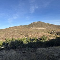
The first mile is pretty uninteresting as it is on a fire road. - Then you hit an open dirt plateau, walk straight across to the open path on the opposite side. - The remaining 1.3 miles is really fun -- lots of scrambling up boulders, and then a little challenging rope climb through a chimney to get to the peak where there are fantastic views Things to know: Cell service is spotty up there, so if you are going to use Google Maps to find the trailhead,, start to navigate while you are still in a populated area with cell service. Finding the entrance to the chimney can be tricky. There were three of us that were close to it, but it took us about 10 minutes to find it. To make it easy for the rest of you to find: download the What3Words app in advance, and when you get to the point that you are actively looking for the chimney, put in the words "dreadful.joining.tilts" and hit Navigate / Compass Mode...this should guide you to the exact entrance of the chimney. (( Side note, if you are not familiar with What3Words, watch this cool 5 minute TedTalk by its founder: https://www.ted.com/talks/chris_sheldrick_a_precise_three_word_address_for_every_place_on_earth )) 
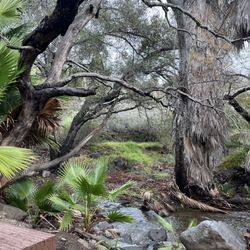
There are lots of holly-like shrubbery on the second half of the trail. Long pants aren't required, but they can definitely help you avoid abrasion. It gets hot there: the high was supposed to be 60 degrees in that area yesterday, but it felt like it was in the 70s when we were doing the hike. This is definitely a hike to do when the weather is cold in San Diego proper. Download the All-Trails trailmap in advance: the latter 1.3mi is not well-marked, and having that GPS accessible trailmap sped up our hike by letting us know if we were getting off the beaten path. For a meal afterwards, I recommend Panchos: we went to Panchos Mexican on Jamacha Rd....huge serving sizes, and very tasty.

    Hiked this back in early March. I liked that there were very few people on the trail. It is steep…read morefrom the beginning but not too difficult. Small area to park by the start of the trail which is a yellow gate. Once you get close to the peak there is not much of a trail and you need to pick a path over boulders. I made my way around to the back of the peak on the west side and found the rope. There are some rock and some wooden make-shift steps to help you get up to the top with the cave. Sadly, maybe because I was alone with no one to assist and maybe not strong enough I did not make it up...bummer. It is just under 5 miles and will take 2-3 hrs most likely.

    Big Laguna Trail

    Big Laguna Trail

    (3 reviews)

    Located in Mount Laguna (Not in Rancho Bernardo as the Yelp page states), this is a network of…read moretrails that ends up at or around Big Laguna lake. Hiking wise there are three approaches. From the south up, from the north down (my entry point), and from the side ( though a privately managed campground). From a milage perspective, expect around 6-8 miles total if you do a full loop from the north or south. Of course just walking to the lake and back will put you around 4 miles using the most direct trails. Family-friendly, but these trails are heavily used by mountain bikers. Ideally, these trails are great for both hiker and biker. Know the unwritten social rules of the road before biking/hiking here. Always put your head on a swivel. Some bikes go very fast. Always have an adult in front and behind the kids if you're hiking as a family. If you're a biker, have a bell on your bike and if you're in a group of bikers be sure to let hikers know if there are more bikers trailing behind you. These rules seemed to be understood by most people on this trail. NOT PUP FRIENDLY. Unless you go during December through March don't bring your dogs. The afternoon that we visited (early June) is was about 80 outside and there were several dog rescues that were performed. We assisted in one of them. Wasn't uncommon to see dog owners carrying their dogs during the final stretch. Altitude plus moderate sun/heat exposure is what defines this trail. Plus ticks and snakes. Keep the pups at home. - lots of snakes here. Stay on trail.

    It's a fun trail, not very difficult. The lake looked like it could use some TLC. There are lots of…read morecamping sites near by so good for the family.

    Coast To Crest Trail

    Coast To Crest Trail

    (13 reviews)

    My 1000th review goes to the Coast to Crest Trail which is the path of the coast of Del Mar going…read moreall the way inland towards Volcan Mountain by Julian! I love this hike within the San Dieguito River Park especially the San Pasqual Valley segment. I've been doing this particular hike along the trail the past four years and it's awesome. Parking is plentiful and a cinch to find! I start this at the *San Pasqual Staging Area* which starts by a citrus grove, then passes a large turf grass farm, abandoned buildings, a closed dairy, and scenic views from afar amidst the vegetation and unique species of plants along the path headed towards *Ysabel Staging Area* which is about 6 miles out and back. I definitely enjoy exploring the San Pasqual Agricultural Preserve and all of it's beauty and history. There are more bicyclists than hikers along this route, which is pretty sweet for it being a mellow path. Next time I definitely want to turn it up a notch by doing one of the longer hikes which I believe will be about 12- 22 miles if I go further out. :)

    This is a nice hiking (and bicycle) trail that roughly follows the San Diequito River from the San…read moreDiequito Lagoon eastward. The area around the Lake Hodges one of my favorites. Sadly, the Lake is considerably smaller that we moved here 20+ years ago because of droughts and Dam repairs. Recently, the Lake Hodges Dam has been found to have very serious problems that will require significant reconstruction or replacement. The water level will kept at the 280 foot level. It may be 2034 before the Lake returns to "normal".

    Otay Border Cycling - nonprofit - Updated May 2026

    Loading...
    Loading...
    Loading...