
Neuse River Greenway Trail Photos


More like Neuse River Greenway Trail
Recommended Reviews - Neuse River Greenway Trail
Start your review...

Reviews With Photos - Neuse River Greenway Trail

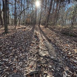
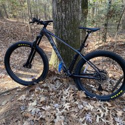
The Best Bike Trail Ever! No kidding. The trail is paved and mostly through wooded areas, which provide excellent shade and scenery. I biked for 15 miles one way and only crossed one country road and two or three private drives. I can't think of a better trail to take the family on and not have to worry about traffic. There are a few dips here and there, but most riders will be able to handle them. The paths are very smooth. I have ridden trails in Boston, Toronto, Montreal, Wisconsin, Illinois, Indiana, Michigan, Tennessee, etc., and I have never ridden on a nicer trail! Hats off to North Carolina! Now if others would use it for a model to develop their own. My pictures are not very good. I only took two as an after thought. I was too engrossed in just riding and enjoying the scenery. So look at those posted by others.

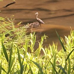
This was a beautiful trail. It was our first time walking it. We went on a Monday evening around 6 pm and there were a good amount of people on it. Many people ride their bikes. I promise I'm not a Karen when I say that I recommend reading the sign with the rules. The trail wasn't very wide so you need to be aware to walk on the right side of the trail, and not have your dog on a long leash because the bikers zoom by and it can cause accidents. We brought our dog and learned the hard way with a close call. We ran into a family of five deer, a couple of geese, and small furry wildlife creatures. It was beautiful.

I spend at least a portion of every week on the Neuse River Trail. In the heat of the summer it's at least 5 degrees cooler by the river under the shady trees, in the fall the colors of changing leaves remind me of the mountains and in the winter it's easy to share the walk within a few yards of the resident wildlife. A treasure for those who need a break from city life.

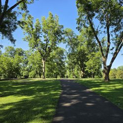
This greenway trail is impressive for its length. I've visited more than one section of it but the amount I've covered must be a small fraction of what's available. It's wide and easy to traverse by foot or by bike. The river isn't anything special, but it's peaceful. Classic North Carolinian plant life abounds. Because the trail is so long, the odds of unmanageable crowds are relatively low, and if you find one parking area full, you can always try somewhere else. It's a good resource to have near the tri-cities.

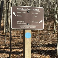
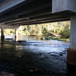
The entire Capital Greenway system has a page, but this area (arguably the best) doesn't, so I'm adding it. The trail starts at Falls Dam right at the base of Falls Lake. There is more than enough parking for bikers, walkers, kayakers, floaters,swimmers, and gawkers. From this point down to the WRAL Soccer Fields, you've got about 6.5 miles. At the fields, there is another big parking area. While riding, you'll see a few apartments, some canoe drop spots (Capital Blvd bridge), and some old aqueducts. The trail traditionally ended at WRAL and Riverside subdivision, but has finally been green-lighted to continue on down to Horseshoe Farm Park and on to the rest of the system. This is very good news for bikers and paddlers as it allows for more connection and more drops. The connection is now under construction and will be ready in September or October of this year. Very good news!!!


As a Durhamite I frequent the ATT a lot but it has its negatives. The fact that so many streets intersect it makes for a lot of stopping while cycling and some areas can be a little sketch. A good friend of mine turned me onto the Neuse River Greenway and I love it! There is a fair amount of parking at the trail head; I used 9745 Fonville Road, Wake Forest, NC 27587 address to find it.The parking lot is located across the street.There are bathrooms at the parking lot which is a plus before a long ride. The best part is there is little to no stopping for cyclists! The Neuse River Trail is a 10-foot wide asphalt path extending from Falls Lake Dam to the Wake County line, a distance of 28 miles. The part that we biked was fairly flat, well shaded, and had some nice views of the river. If you are looking for a safe place to ride and or walk I highly suggest it.


When I moved to Raleigh our real estate agent has told us about the Greenway, but when I purchased my house I had no idea we lived so close to an entrance, or how much I would enjoy this wonderful place. It is not often a government gets something right, but in the case of the Greenway they nailed it in my opinion. Laid out nicely along the Neuse River. Trash cans set up so people can dispose of their garbage. A great place to jog, walk or ride your bike. I wish more cyclists would announce themselves when coming up from behind, but hey what would the world be without assholes. Enjoy a relaxing couple of ours and take a hike. Relatively flat and you can go as far as you like. read more


Great place to bike, run, or walk! It was so beautiful and kept me entertained during my entire ride. I also appreciate how easy it is to follow because I get lost easily. I parked at the baseball fields off of buffalo road and headed up towards the dams at falls lake, and I enjoyed every minute of it. The trail is super wide, so there's plenty of room to pass safely. Make sure to pack you own water, I didn't see anywhere to fill up. read more


I loved walking here today. Although it was quite warm and some would say hot, it didn't feel too bad because of the trees which provided good shade. The trails are long enough to get your steps in or even a decent bike ride. Dogs are welcome too. The scenery and fresh scents were also highlights of my walk. However, the icing on the cake came from the birds and animals. The chirping sound of the birds felt refreshing while the squirrels and deer added to the amazing view. If I lived near here l would make this a regular place to visit. read more


3 years ago
The Best Bike Trail Ever! No kidding. The trail is paved and mostly through wooded areas, which provide excellent shade and scenery. I biked for 15 miles one way and only crossed one country road and two or three private drives. I can't think of a better trail to take the family on and not have to worry about traffic. There are a few dips here and there, but most riders will be able to handle them. The paths are very smooth. I have ridden trails in Boston, Toronto, Montreal, Wisconsin, Illinois, Indiana, Michigan, Tennessee, etc., and I have never ridden on a nicer trail! Hats off to North Carolina! Now if others would use it for a model to develop their own. My pictures are not very good. I only took two as an after thought. I was too engrossed in just riding and enjoying the scenery. So look at those posted by others. read more
3 years ago
This was a beautiful trail. It was our first time walking it. We went on a Monday evening around 6 pm and there were a good amount of people on it. Many people ride their bikes. I promise I'm not a Karen when I say that I recommend reading the sign with the rules. The trail wasn't very wide so you need to be aware to walk on the right side of the trail, and not have your dog on a long leash because the bikers zoom by and it can cause accidents. We brought our dog and learned the hard way with a close call. We ran into a family of five deer, a couple of geese, and small furry wildlife creatures. It was beautiful. read more


I spend at least a portion of every week on the Neuse River Trail. In the heat of the summer it's at least 5 degrees cooler by the river under the shady trees, in the fall the colors of changing leaves remind me of the mountains and in the winter it's easy to share the walk within a few yards of the resident wildlife. A treasure for those who need a break from city life. read more


This greenway trail is impressive for its length. I've visited more than one section of it but the amount I've covered must be a small fraction of what's available. It's wide and easy to traverse by foot or by bike. The river isn't anything special, but it's peaceful. Classic North Carolinian plant life abounds. Because the trail is so long, the odds of unmanageable crowds are relatively low, and if you find one parking area full, you can always try somewhere else. It's a good resource to have near the tri-cities. read more


3 years ago
4 years ago
7 years ago
The entire Capital Greenway system has a page, but this area (arguably the best) doesn't, so I'm adding it. The trail starts at Falls Dam right at the base of Falls Lake. There is more than enough parking for bikers, walkers, kayakers, floaters,swimmers, and gawkers. From this point down to the WRAL Soccer Fields, you've got about 6.5 miles. At the fields, there is another big parking area. While riding, you'll see a few apartments, some canoe drop spots (Capital Blvd bridge), and some old aqueducts. The trail traditionally ended at WRAL and Riverside subdivision, but has finally been green-lighted to continue on down to Horseshoe Farm Park and on to the rest of the system. This is very good news for bikers and paddlers as it allows for more connection and more drops. The connection is now under construction and will be ready in September or October of this year. Very good news!!! read more


 connecting Upper Neuse Greenway to the rest of it. - Hiking Near Me - Wake Forest, North Carolina")
8 years ago
Well maintained greenway trail. Peaceful and serene with not too many cyclists whizzing by. read more

6 years ago
9 years ago
As a Durhamite I frequent the ATT a lot but it has its negatives. The fact that so many streets intersect it makes for a lot of stopping while cycling and some areas can be a little sketch. A good friend of mine turned me onto the Neuse River Greenway and I love it! There is a fair amount of parking at the trail head; I used 9745 Fonville Road, Wake Forest, NC 27587 address to find it.The parking lot is located across the street.There are bathrooms at the parking lot which is a plus before a long ride. The best part is there is little to no stopping for cyclists! The Neuse River Trail is a 10-foot wide asphalt path extending from Falls Lake Dam to the Wake County line, a distance of 28 miles. The part that we biked was fairly flat, well shaded, and had some nice views of the river. If you are looking for a safe place to ride and or walk I highly suggest it. read more

11 years ago
9 years ago
Beautiful trail. I'm new to the area and I am excited to explore more if this trail. The trail is nicely paved and wide enough for both lanes of walkers or bikers to pass each other safely. read more


9 years ago
I have lived here for several years and have grown up with the trail. I can definitely say that every time I go it's never the same experience. I absolutely love how gorgeous the trail is. The nature is beautifully well maintained and the river alongside the greenway is nice to have. There are a few openings within the greenway that I recommend taking for an extra adventure while on the greenway. I always see cardinals and bunnies :) read more

9 years ago
9 years ago
11 years ago
10 years ago
9 years ago
10 years ago
More info about Neuse River Greenway Trail
12098 New Falls Of Neuse Rd
Wake Forest, NC 27587
Directions
Hours
Indoor Amenities
Outdoor Amenities
Ask the Community - Neuse River Greenway Trail
Review Highlights - Neuse River Greenway Trail


Neuse River Greenway Trail - hiking - Updated July 2026
Best of Wake Forest
People found Neuse River Greenway Trail by searching for…
Places to Take Pictures in Wake Forest, NC
Sunset View in Wake Forest, NC
Scenic Drive in Wake Forest, NC
Walking Trails in Wake Forest, NC
Hiking Trails With Waterfalls in Wake Forest, NC
Fun Things to Do in Wake Forest, NC
Watch Sunset in Wake Forest, NC
Running Trails in Wake Forest, NC
Photo Spots in Wake Forest, NC
Scenic Night View in Wake Forest, NC
Secluded Spots in Wake Forest, NC
Swimming Lakes in Wake Forest, NC
Off Road Trails in Wake Forest, NC
Scenic Overlook in Wake Forest, NC
Flower Field in Wake Forest, NC
Dirt Bike Trails in Wake Forest, NC
Dog Friendly Parks in Wake Forest, NC
Trending Searches in Wake Forest, NC
Blueberry Picking near Neuse River Greenway Trail
Boat Tours near Neuse River Greenway Trail
Cliff Jumping near Neuse River Greenway Trail
Day Trips near Neuse River Greenway Trail
Jet Ski Rental near Neuse River Greenway Trail
Kayak Rental near Neuse River Greenway Trail
Kids Activities Indoor near Neuse River Greenway Trail
Lakes near Neuse River Greenway Trail
Off Road Trails near Neuse River Greenway Trail
Outdoor Activities near Neuse River Greenway Trail
Peach Picking near Neuse River Greenway Trail
Picnic Spots near Neuse River Greenway Trail
Places To Walk Around near Neuse River Greenway Trail
Public Shower near Neuse River Greenway Trail
Rainy Day Activities near Neuse River Greenway Trail
River Swimming near Neuse River Greenway Trail
Rock Quarry near Neuse River Greenway Trail
Scenic Night View near Neuse River Greenway Trail
Scenic Overlook near Neuse River Greenway Trail
State Parks near Neuse River Greenway Trail
Swimming Holes near Neuse River Greenway Trail
Swimming Lakes near Neuse River Greenway Trail
Things To Do On A Rainy Day near Neuse River Greenway Trail
Things To Do With Teenagers near Neuse River Greenway Trail
Tubing near Neuse River Greenway Trail
View Points near Neuse River Greenway Trail
Watch Sunset near Neuse River Greenway Trail
Browse Articles
Browse Nearby
BEST of Wake Forest, North Carolina Coffee near Neuse River Greenway Trail
BEST of Wake Forest, North Carolina Restaurants near Neuse River Greenway Trail
BEST of Wake Forest, North Carolina Things to Do near Neuse River Greenway Trail
BEST of Wake Forest, North Carolina Breakfast near Neuse River Greenway Trail
BEST of Wake Forest, North Carolina Parks near Neuse River Greenway Trail
BEST of Wake Forest, North Carolina Horseback Riding near Neuse River Greenway Trail
Browse Brands
Related Searches in Wake Forest, NC
Affordable Kayak Rental Services in Wake Forest, North Carolina
Best Dog Hiking Trails Around Wake Forest, North Carolina
Best Fishing Locations and Guides in Wake Forest, North Carolina
Best Places for Horseback Riding in Wake Forest, North Carolina
Check Out Off Road Trails in Wake Forest, North Carolina
Discover Dog Friendly Trails to Explore in Wake Forest, North Carolina
Discover Kid Friendly Hiking Trails in Wake Forest, North Carolina
Discover Popular Bike Trails in Wake Forest, North Carolina
Discover Scenic Mountain Bike Trails Near Wake Forest, North Carolina
Discover a Hiking Trail in Wake Forest, North Carolina
Discover the Best Night Hike Trails in Wake Forest, North Carolina
Dog-Friendly Hikes With Dogs in Wake Forest, North Carolina
Enjoy Camping Adventures Around Wake Forest, North Carolina
Enjoy Kayaking Adventures in Wake Forest, North Carolina
Enjoy Off Leash Dog Hikes in Wake Forest, North Carolina
Enjoy Scenic Places to Walk in Wake Forest, North Carolina
Enjoy Tent Camping Spots Around Wake Forest, North Carolina
Enjoy a Beautiful Waterfall Hike in Wake Forest, North Carolina
Enjoy the Best Picnic Spots and Ideas in Wake Forest, North Carolina
Enjoy the Best Walking Trails in Wake Forest, North Carolina
Explore Beautiful Parks and Green Spaces in Wake Forest, North Carolina
Explore Easy Hikes Perfect for All in Wake Forest, North Carolina
Explore Fun Activities to Do in Wake Forest, North Carolina
Explore Popular Campgrounds Near Wake Forest, North Carolina
Explore Top Dog Parks in Wake Forest, North Carolina Near You
Explore the Best Beach Spots in Wake Forest, North Carolina
Family Friendly Hiking With Kids in Wake Forest, North Carolina
Find Beautiful Views in Wake Forest, North Carolina
Find Popular Ziplining Spots Around Wake Forest, North Carolina
Find Top Dog Friendly Parks to Visit in Wake Forest, North Carolina
Find Top-Rated Waterfalls in Wake Forest, North Carolina Now
Find the Best Parks for Picnics in Wake Forest, North Carolina
Find the Best Playgrounds to Visit in Wake Forest, North Carolina
Hiking Trails With Waterfalls in Wake Forest, North Carolina
Off Leash Dog Hiking Trails in Wake Forest, North Carolina
Popular Fishing Spots to Explore in Wake Forest, North Carolina
Popular Outdoor Activities to Try in Wake Forest, North Carolina
Popular Picnic Spots to Visit in Wake Forest, North Carolina
Safe River Swimming Areas in Wake Forest, North Carolina
Safe and Fun Parks for Kids in Wake Forest, North Carolina
Top Hiking Trails to Explore in Wake Forest, North Carolina
Top Playgrounds for Kids to Enjoy in Wake Forest, North Carolina
Top Running Trails to Explore in Wake Forest, North Carolina
Top Swimming Lakes to Enjoy in Wake Forest, North Carolina
Top Swimming Spots and Pools in Wake Forest, North Carolina
Top Things to Do With Kids in Wake Forest, North Carolina
Top-Rated Camping Sites in Wake Forest, North Carolina
Walk Dog Friendly Hiking Trails in Wake Forest, North Carolina
Walk the Best Paved Walking Trails in Wake Forest, North Carolina
People who viewed Neuse River Greenway Trail also viewed
Capital Area Greenway
10 reviews
William B Umstead State Park
185 reviews
White Oak Creek Greenway
3 reviews
Swift Creek Bluffs Nature Preserve
10 reviews
William B Umstead State Park
7 reviews
Lake Johnson Park
150 reviews
Brookhaven Nature Park
5 reviews
Fred G Bond Metro Park
88 reviews
North Raleigh Trail
4 reviews
Mountains To Sea Trail
2 reviews