Mt Hood Summit Photos


More like Mt Hood Summit
Recommended Reviews - Mt Hood Summit
Start your review...

Reviews With Photos

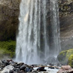
We absolutely LOVED Mt Hood, Oregon's tallest peak. What a peaceful, beautiful place! How could you not love chilling on a 11,245 foot snow covered stratovolcano in the stunning PNW region of the country?! We could've stayed for hours and hours, even all night to camp which can be done in many, many campgrounds in the area at the base, but also actually ON the mountain which is done in a walk in, no cost, primitive manor. Very cool! I can only imagine the sunrises and sunsets from up there! The drive to the top of the mountain is roughly 30 minutes. The road is winding, but clearly paved the entire way, and has some guard rails. Not nearly as dangerous as some other mountain roads, but still watch your speed, especially on curves, and I would not recommend driving them in the dark. I mean, you are on a cliff after all. Some may feel the elevation change as you rise, but all will feel their ears pop. Gum can't hurt. Mt Hood is home to 12 glaciers, the most visited being Palmer Glacier which is at a 3,690 vertical ft slope. I can safely assume its popularity is because of its proximity to Timberline Lodge, the only ski lodge in the US open all 12 months of the year. The Lodge may look a bit familiar to you as it's in the opening scenes of "The Shining"! Creepy cool! Those not interested in actually getting on the the mount can just head up the road by plugging the address of the lodge into your GPS. From there you can take photos and visit the lodge. Even that I feel is worth the trek up. Palmer Glacier is where we personally headed up the mountain on foot, and where you can catch the ski lift in the summer and springs seasons IF you arrive before 2pm. In the winter and fall you can grab a snowcat up to the top. We didn't catch the lift and my little girl ages 6 & 8 at the time found hiking to be easy, but we didn't rise above 2 1/2-3 miles or so. It was the point at which we felt safest, and the maximum height I would recommend with littles. We visited in the summer and the kiddos just LOVED playing in the snow in July! What a trip! Definitely worth a visit with kiddos to have a snowball fight up there especially if you're traveling here during warm months! Don't tell them what's in store for them and blow their minds! Bring closed toes shoes! Obviously. While you can ski and snowboard all year round on Mt Hood, there couldn't have been more signs warning of the dangers. I believe you have to sign a waiver actually. What looks like such a calm place is actually quite dangerous. Over 10,000 climbers a year, especially in the spring attempt to summit the mount. Many do not it make it. Approximately 10 a year die from various injuries on Mt Hood. Hogsback and Zig Zag are perhaps the most deadly trails. Spring is the most popular time for climbing as the snow is melting, but the ice still falls. Mt. Hood is famous for falling rocks. Shortly after we visited two young girls who were setting up to camp fell over 100 ft to their death and they weren't even participating in snow sports. Please be careful!! We highly recommend a visit here! It's so close to Portland it's ridiculous! It was definitely a highlight on our month long road trip for my girls! You can choose a few hours or days! Winter sports or not...it's still an amazing place to see with your own eyes. From the top you even can look over at the peak of Mt St Helen's volcano and experience a pretty gorgeous (cold) waterfall on your right hand side headed back down 28! Splash, but hold onto the real wee ones as there's a bit of an undertow. It's pretty manageable though.

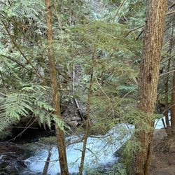
Cool Uncrowded Nature Area! This is a nice less crowded area to get some nature time and hiking in... Unless of course you are at the every crowded Lost Lake Park which is also nice, but definitely crowded! The mountain itself is monolithic to say the least and even in late June was totally snow covered which was somewhat surprising for us of course not being locals... Snowshoes are a must if you plan to reach the summit or you will have a terrible time unless you are lucky enough to find some hard pack snow to float on. If not for logging this area would be 5 stars of goodness! Cool hiking option abound as you work your way around the mountain but lots of logging operations have seriously take its toll on this area! Entire sections of forest have been clear cut and even though they plant more saplings eventually they really don't seem to clean the mess up or even grind the stumps so many areas look like the land has been raped by unscrupulous companies and maybe the government should stop clear cut logging and require at least some trees remain...

I'ts been three days and this mountain is still annoying me, maybe its the people. Its such a weird alpine experience. It is so insanely crowded, the entire trail, is quite unenjoyable. There is traffic jams, loud people, weird energy sometimes. Good luck with parking if you don't get a alpine start. The sludge up to palmer lift is hard steep and not rewarding. There are better views with less effort such as St. Helens, which is not as crowded and actually has interesting landscape. Mt hood you literally spend so much of your time next to a groomed ski track/lifts and its anything but natural looking. The first half of the climb I found to be quite boring, and the last half was too annoying to enjoy with ten thousand climbers on the mountain. I don't know why everyone loves this mountain so much, it pails in comparison to Mt Rainer, Camp Muir, basically most other alpine experiences. It's not a bad climb, but if you are trying to pick a climb, there are much better ones if you are willing to drive. I would give this hie 4/5 stars if it wasn't so annoyingly crowded at all times, deducting one star for the boring sludge up the first half and basically being very uninteresting most of the way up. -Wesley Clarillos

Through a big part of Oregon, views of Mt Hood is a special treat. It is beautiful and it tells you that it is a clear day. When I am flying in and out of the Portland airport I watch for a view. It's a great mountain to look at. Up close is just as good. I recently drove over part of the mountain on a return trip from Bend. It was a nice day giving us views most of the trip. We stopped at Meadows and Timberline. Both were great. There is a lot of fun to have on the mountain.

A must see really amazing While visiting clolumbia river gorge scenic route Also went to Mount Hood was amazing make the time Tips: Set your GPS to the timberline lodge address, takes right to mount hood Go to Trillium lake (need on day parking( for amazing pics of mount hood and lake on the background when not cloudy. Amazing views This is amazing to see summer to walk or enjoy the hikes winter to sky and enjoy the snow. You may need chains or rent a SUV with AWD. Like a Subaru or Toyota RAV4 We loved the area so many things to do not enough time.


The mountain air is the best . Microbrewery at Govt Camp was good. The hike down from the chair lift was fun. The jacuzzi at the Timberline was just right. The vision of FDR remains timeless. The craftsmanship is remarkable before the advent of power tools....... The Blacksmith was in a wheel chair however his upper body strength and artistic skill Is again ahead of its time...... Matt from Conn/Vt was an excellent waiter at the Timberline breakfast with the mugs of coffee. Our son from vt and NJ enjoyed freestyle skiing in July with Windells.


Mt. Hood is no doubt a magnificent sight. I have been wanting to visit the mountain for over a decade now and I was so glad I finally did. I was pleased, being June, that there was still plenty of snow on the mountain. Reaching 11, 250 feet I should not be surprised. Also, the temperature during my visit was very comfortable reaching the high 50's at the base of the mountain. It was perfect for meandering around and soaking in the awesome view. This mountain is definitely worth visiting if you are an enthusiast of geological formations or adventures. read more


Most of what I've written about the people that taught me to climb: https://www.yelp.com/biz/mazamas-portland Also applies to the *place* where I learned to climb. This is a really special mountain to me. It's not just "The Mountain" that I brag to all my friends back East about: "Portland is only an hour form the mountain!" It's a second home. It's where I learned to not trip on my crampons and get used to cold hands and even colder toes. It's where I learned that an Acura TL can make it up the mountain in a blizzard, as long as you have the grit to chain-up in Government Camp. It's where I almost lost people. It's where I made new friends. It's where I hung out with ravens on the summit. It's where I nearly threw up from noxious sulfur fumes. It's where I witnessed rescue efforts. It's where I learned to shoot the stars. It's where I taught others climbing knots. It's where I spent a lot of time alone, at 2am, wondering why I wasn't closing down a bar in Portland. It's where I saw the alpenglow creep over the horizon at 5am and realized all the suffering was worth it. read more


9 years ago
We absolutely LOVED Mt Hood, Oregon's tallest peak. What a peaceful, beautiful place! How could you not love chilling on a 11,245 foot snow covered stratovolcano in the stunning PNW region of the country?! We could've stayed for hours and hours, even all night to camp which can be done in many, many campgrounds in the area at the base, but also actually ON the mountain which is done in a walk in, no cost, primitive manor. Very cool! I can only imagine the sunrises and sunsets from up there! The drive to the top of the mountain is roughly 30 minutes. The road is winding, but clearly paved the entire way, and has some guard rails. Not nearly as dangerous as some other mountain roads, but still watch your speed, especially on curves, and I would not recommend driving them in the dark. I mean, you are on a cliff after all. Some may feel the elevation change as you rise, but all will feel their ears pop. Gum can't hurt. Mt Hood is home to 12 glaciers, the most visited being Palmer Glacier which is at a 3,690 vertical ft slope. I can safely assume its popularity is because of its proximity to Timberline Lodge, the only ski lodge in the US open all 12 months of the year. The Lodge may look a bit familiar to you as it's in the opening scenes of "The Shining"! Creepy cool! Those not interested in actually getting on the the mount can just head up the road by plugging the address of the lodge into your GPS. From there you can take photos and visit the lodge. Even that I feel is worth the trek up. Palmer Glacier is where we personally headed up the mountain on foot, and where you can catch the ski lift in the summer and springs seasons IF you arrive before 2pm. In the winter and fall you can grab a snowcat up to the top. We didn't catch the lift and my little girl ages 6 & 8 at the time found hiking to be easy, but we didn't rise above 2 1/2-3 miles or so. It was the point at which we felt safest, and the maximum height I would recommend with littles. We visited in the summer and the kiddos just LOVED playing in the snow in July! What a trip! Definitely worth a visit with kiddos to have a snowball fight up there especially if you're traveling here during warm months! Don't tell them what's in store for them and blow their minds! Bring closed toes shoes! Obviously. While you can ski and snowboard all year round on Mt Hood, there couldn't have been more signs warning of the dangers. I believe you have to sign a waiver actually. What looks like such a calm place is actually quite dangerous. Over 10,000 climbers a year, especially in the spring attempt to summit the mount. Many do not it make it. Approximately 10 a year die from various injuries on Mt Hood. Hogsback and Zig Zag are perhaps the most deadly trails. Spring is the most popular time for climbing as the snow is melting, but the ice still falls. Mt. Hood is famous for falling rocks. Shortly after we visited two young girls who were setting up to camp fell over 100 ft to their death and they weren't even participating in snow sports. Please be careful!! We highly recommend a visit here! It's so close to Portland it's ridiculous! It was definitely a highlight on our month long road trip for my girls! You can choose a few hours or days! Winter sports or not...it's still an amazing place to see with your own eyes. From the top you even can look over at the peak of Mt St Helen's volcano and experience a pretty gorgeous (cold) waterfall on your right hand side headed back down 28! Splash, but hold onto the real wee ones as there's a bit of an undertow. It's pretty manageable though. read more


 - Climbing Near Me - Mount Hood, Oregon")


9 years ago
Cool Uncrowded Nature Area! This is a nice less crowded area to get some nature time and hiking in... Unless of course you are at the every crowded Lost Lake Park which is also nice, but definitely crowded! The mountain itself is monolithic to say the least and even in late June was totally snow covered which was somewhat surprising for us of course not being locals... Snowshoes are a must if you plan to reach the summit or you will have a terrible time unless you are lucky enough to find some hard pack snow to float on. If not for logging this area would be 5 stars of goodness! Cool hiking option abound as you work your way around the mountain but lots of logging operations have seriously take its toll on this area! Entire sections of forest have been clear cut and even though they plant more saplings eventually they really don't seem to clean the mess up or even grind the stumps so many areas look like the land has been raped by unscrupulous companies and maybe the government should stop clear cut logging and require at least some trees remain... read more

4 years ago
I'ts been three days and this mountain is still annoying me, maybe its the people. Its such a weird alpine experience. It is so insanely crowded, the entire trail, is quite unenjoyable. There is traffic jams, loud people, weird energy sometimes. Good luck with parking if you don't get a alpine start. The sludge up to palmer lift is hard steep and not rewarding. There are better views with less effort such as St. Helens, which is not as crowded and actually has interesting landscape. Mt hood you literally spend so much of your time next to a groomed ski track/lifts and its anything but natural looking. The first half of the climb I found to be quite boring, and the last half was too annoying to enjoy with ten thousand climbers on the mountain. I don't know why everyone loves this mountain so much, it pails in comparison to Mt Rainer, Camp Muir, basically most other alpine experiences. It's not a bad climb, but if you are trying to pick a climb, there are much better ones if you are willing to drive. I would give this hie 4/5 stars if it wasn't so annoyingly crowded at all times, deducting one star for the boring sludge up the first half and basically being very uninteresting most of the way up. -Wesley Clarillos read more

Through a big part of Oregon, views of Mt Hood is a special treat. It is beautiful and it tells you that it is a clear day. When I am flying in and out of the Portland airport I watch for a view. It's a great mountain to look at. Up close is just as good. I recently drove over part of the mountain on a return trip from Bend. It was a nice day giving us views most of the trip. We stopped at Meadows and Timberline. Both were great. There is a lot of fun to have on the mountain. read more


10 years ago
A must see really amazing While visiting clolumbia river gorge scenic route Also went to Mount Hood was amazing make the time Tips: Set your GPS to the timberline lodge address, takes right to mount hood Go to Trillium lake (need on day parking( for amazing pics of mount hood and lake on the background when not cloudy. Amazing views This is amazing to see summer to walk or enjoy the hikes winter to sky and enjoy the snow. You may need chains or rent a SUV with AWD. Like a Subaru or Toyota RAV4 We loved the area so many things to do not enough time. read more


2.5 hours drive from Portland but well worth it. Gorgeous view and it's post card perfect no matter if you're far away, almost there or right below the mountain itself. I saw some peeps skiing down the slopes on a 97* day. read more


11 years ago
The mountain air is the best . Microbrewery at Govt Camp was good. The hike down from the chair lift was fun. The jacuzzi at the Timberline was just right. The vision of FDR remains timeless. The craftsmanship is remarkable before the advent of power tools....... The Blacksmith was in a wheel chair however his upper body strength and artistic skill Is again ahead of its time...... Matt from Conn/Vt was an excellent waiter at the Timberline breakfast with the mugs of coffee. Our son from vt and NJ enjoyed freestyle skiing in July with Windells. read more

19 years ago
Mt. Hood seems like it's about to erupt. So I ask myself, "Why are we skiing and climbing all over it?" Answer: Let's go down to the beach and watch the tsunami come in. Heavy Dude read more


8 years ago
Yes. See for yourself and be blown away by the beauty of this Cascadian pleasure. Attempted to summit, but the conditions weren't right. I'll update this review with more photos once I complete a summit. read more

10 years ago
12 years ago
What an amazing bit of History that is here at the top of Mount Hood. What an amazing Mountain in what seems like the middle of it all. It to me was a bit of a scary climb up here. But, so amazingly worth it! It is the middle of summer and people are up here skiing and snowboarding. So cool, so fun! The drive up here is beautiful, lovely fresh water springing out of the side of the mountain even. If you are thirsty, you can just stop and have a drink. At the top of the Mountain is the fabulous Lodge. Built during the Depression to give the locals some work. A wonderful , interesting, Building. All heavy beautiful wood, all made by hand. A true tribute to the great men and women of this country that joined together in the hardest time they had seen and built a magnificent Building that stands today just as incredible as it was almost 100 years ago. I am looking forward to the future where I can actually stay at the lodge and spend the night. The Mountain itself is clean and well kept, people are enjoying it and loving it. The view is just as great as you could imagine. read more


13 years ago
13 years ago
The best mountain in the world. The mountain all other mountains want to be. Can be a real sweetheart that can satisfy most of your sporting and or spiritual needs but you must respect the mountain. The view from the top is unbelievable. Four great ski /boarder areas; multiple lakes; fantastic hiking trails; the quintessential Timberline Lodge. Only the jaded would find fault with this mountain. read more


11 years ago
13 years ago
8 years ago
7 years ago
9 years ago
17 years ago
18 years ago
12 years ago
16 years ago
More info about Mt Hood Summit
Mt Hood Summit
Mount Hood, OR 97041
Directions
Hours
Outdoor Amenities
Ask the Community - Mt Hood Summit
Review Highlights - Mt Hood Summit


Why does Yelp recommend reviews?
1 review that is not currently recommended
The reviews below are not factored into the business's overall star rating.
15 years ago
Mt Hood Summit - climbing - Updated July 2026
Best of Mount Hood
People found Mt Hood Summit by searching for…
Things to Do in Mount Hood, Oregon
Sledding in Mount Hood, Oregon
Hiking Trails With Waterfalls in Mount Hood, Oregon
Sunset View in Mount Hood, Oregon
Scenic View in Mount Hood, Oregon
Attractions in Mount Hood, Oregon
Campgrounds in Mount Hood, Oregon
Sunrise View in Mount Hood, Oregon
Scenic Drive in Mount Hood, Oregon
Waterfalls and Swimming Holes in Mount Hood, Oregon
Dog Friendly Hiking Trails in Mount Hood, Oregon
Off Road Trails in Mount Hood, Oregon
Natural Hot Springs in Mount Hood, Oregon
Watch Sunset in Mount Hood, Oregon
Sunrise Hike in Mount Hood, Oregon
Flower Fields in Mount Hood, Oregon
Lookout Points in Mount Hood, Oregon
Snow Play in Mount Hood, Oregon
Trending Searches in Mount Hood, OR
Berry Picking near Mt Hood Summit
Blueberry Picking near Mt Hood Summit
Boat Rental near Mt Hood Summit
Dog Friendly Trails near Mt Hood Summit
Fruit Picking near Mt Hood Summit
Jet Ski Rental near Mt Hood Summit
Kayak Rental near Mt Hood Summit
Off Road Trails near Mt Hood Summit
Parks For Picnics near Mt Hood Summit
Peach Picking near Mt Hood Summit
Places To Swim near Mt Hood Summit
Public Shower near Mt Hood Summit
River Tubing near Mt Hood Summit
Scenic Overlook near Mt Hood Summit
Splash Pad near Mt Hood Summit
Strawberry Picking near Mt Hood Summit
Swimming Holes near Mt Hood Summit
Swimming Lakes near Mt Hood Summit
Browse Articles
Browse Nearby
Browse Brands
Related Searches in Mount Hood, OR
Affordable Kayak Rental Services in Mount Hood, Oregon
Affordable Paddle Board Rental in Mount Hood, Oregon
Best Gyms With Swimming Pools in Mount Hood, Oregon
Best Places for Horseback Riding in Mount Hood, Oregon
Best Places for Stunning Views in Mount Hood, Oregon
Best Sledding Spots and Fun in Mount Hood, Oregon
Best Spots for Star Gazing in Mount Hood, Oregon
Best Waterfalls and Swimming Holes in Mount Hood, Oregon
Check Out Off Road Trails in Mount Hood, Oregon
Discover Dog Friendly Trails to Explore in Mount Hood, Oregon
Discover Fun Kid Activities to Enjoy in Mount Hood, Oregon
Discover Gyms With Steam Room Options in Mount Hood, Oregon
Discover Kids Yoga Classes Near Mount Hood, Oregon
Discover Top Boat Tours in Mount Hood, Oregon for All Ages
Discover Top Yoga Options and Studios in Mount Hood, Oregon
Enjoy Camping Adventures Around Mount Hood, Oregon
Enjoy Hiking Adventures in Mount Hood, Oregon
Enjoy Kayaking Adventures in Mount Hood, Oregon
Enjoy Tent Camping Spots Around Mount Hood, Oregon
Enjoy a Beautiful Waterfall Hike in Mount Hood, Oregon
Enjoy the Best Family Activities in Mount Hood, Oregon
Enjoy the Best Tubing Experiences in Mount Hood, Oregon
Enjoy the Best Walking Trails in Mount Hood, Oregon
Experience Stunning Sunset Views in Mount Hood, Oregon
Experience Thrilling White Water Rafting in Mount Hood, Oregon
Explore Beautiful Parks and Green Spaces in Mount Hood, Oregon
Explore Bike Rentals Throughout Mount Hood, Oregon
Explore Boxing Gyms in Mount Hood, Oregon
Explore Free Things to Do Around Mount Hood, Oregon
Explore Fun Activities to Do in Mount Hood, Oregon
Explore High End Gyms Available in Mount Hood, Oregon
Explore Popular Campgrounds Near Mount Hood, Oregon
Explore Popular RV Parks Around Mount Hood, Oregon
Explore Popular Scenic Views Near Mount Hood, Oregon
Explore Popular Sports Clubs in Mount Hood, Oregon
Explore Popular View Points Around Mount Hood, Oregon
Explore Scenic Lakes to Visit in Mount Hood, Oregon
Explore Secret Spots Worth Visiting in Mount Hood, Oregon
Explore Summer Camps for All Ages in Mount Hood, Oregon
Explore Top Gyms in Mount Hood, Oregon Now
Explore Top Water Parks in Mount Hood, Oregon Today
Explore the Best Barre Classes Available in Mount Hood, Oregon
Explore the Best Beach Spots in Mount Hood, Oregon
Explore the Best Boating Spots in Mount Hood, Oregon
Explore the Best Swimming Holes Around Mount Hood, Oregon
Explore the Scenic River in Mount Hood, Oregon
Find Fun Kids Activities Outdoor in Mount Hood, Oregon
Find La Fitness Center Locations in Mount Hood, Oregon
Find Top Dog Swimming Spots in Mount Hood, Oregon
Find Top Jiu Jitsu Classes and Training in Mount Hood, Oregon